oak grove boating access facility - smith … · impacts to surrounding neighbors the oak grove...
TRANSCRIPT

5/24/13
PROJECT OVERVIEWAppalachian Power is currently applying for permits to build a double boat ramp as part of the Oak Grove Boating Access Facility. When completed, it will provide the public with greater access to all that Smith Mountain Lake has to offer and will help ensure that visitors are able to enjoy the natural beauty and recreational opportunities that are synonymous with the area.
It is vitally important to balance the needs of the public and those who make their home at Smith Mountain.
GOVERNMENT REGULATIONSThe man-made reservoir is part of Appalachian Power’s Smith Mountain Pumped-Storage Hydroelectric Project, which provides electricity for the region. In 2010, Appalachian Power’s federal license to operate and maintain the hydroelectric project for another 30 years took effect.
This federal license requires that a ramp of this nature needs to be built to provide greater public access to the lake.
Further, the Virginia Department of Game and Inland Fisheries recommended that the Oak Grove Boating Access Facility be constructed at this time due to its proximity to Hales Ford Bridge, an area that draws boaters and recreationalists.
The $1 million Oak Grove project will allow two boats to be launched at one time and will provide 62 parking spaces as well as areas for fishing.
LOCATION AND TIMELINE
The Oak Grove Boating Access Facility will be constructed on approximately 10 acres of land owned by Appalachian Power. It is near Hales Ford Bridge. To access the facility from Route 122, take Merriman Road (Route 666) to Oldfield Road (Route 978) and follow it to Oak Grove Drive (Route 1230).
Appalachian Power is prepared to begin construction on the project this fall and it is expected to be completed in spring 2014.
Franklin County has advised that this project does not need to be rezoned, as the property falls within the company’s hydroelectric project boundary and will be maintained by the Virginia Department of Game and Inland Fisheries.
The Oak Grove facility proposed will look similar to this facility onSmith Mountain Lake in Penhook, Virginia.
OA K G R OV E B OAT I N G ACC E S S FAC I L I T Y
A P P A L A C H I A N P O W E R . C O M

IMPACTS TO SURROUNDING NEIGHBORSThe Oak Grove Boating Access Facility will be constructed and operated with sensitivity to shoreline and community neighbors.
•Every effort will be made to screen the property from view with trees and vegetation where possible.
•The facility’s parking lots are not expected to have any impact on the adjacent water system. Storm water runoff will be handled in accordance with plans approved by Franklin County.
•The Oak Grove facility will utilize dusk to dawn lights. Any lighting installed will be dark skies compatible, not shining on other properties.
•According to a recent traffic study, approximately 50 vehicles are expected to enter and leave the facility on a weekday with double that amount on the weekend. The traffic generated on a weekday would actually be less than if the property were developed for residential use.
FOR MORE INFORMATION ABOUT THE OAK GROVE BOATING ACCESS FACILITY,
VISIT WWW.SMITHMTN.COM
OA K G R OV E B OAT I N G ACC E S S FAC I L I T Y
A P P A L A C H I A N P O W E R . C O M

Traffic Impact & Access AssessmentOak Grove Boating Access Facility, Franklin County, Virginia
July 25, 2012Engineering & Planning Resources, P.C.
N
Site

Oak Grove Boating Access Facility Traffic Impact & Access Assessment, Franklin County, Virginia
Engineering & Planning Resources, P.C. Table of Contents
Table of Contents
1. Introduction .......................................................................................................................................................................................... 012. Background ......................................................................................................................................................................................... 013. Where is the site located? ................................................................................................................................................................... 044. How will the site be accessed from the main road system? ................................................................................................................ 055. How much traffic will the boat facility generate? .................................................................................................................................. 086. As a point of comparison, if the land were subdivided into residential lots per the R-1 zoning, how many vehicle trips would be expected? ............................................................................................................................................................................................ 107. How much traffic is on the roads leading into the site currently? ......................................................................................................... 118. Are the roads built for the current volumes and also the future volumes if the boat facility is built? .................................................... 139. Are there examples of other roads leading to boat access facilities that are of similar widths? .......................................................... 1610. If the road is to be improved, is there a funding source for that effort? ................................................................................................ 1711. Would VDOT take Oak Grove Court into their maintenance system? .................................................................................................. 1812. What about the intersections leading in from Route 122, can they safely accomodate the cars / trucks with trailers? ......................... 1913. Is there any documented safety/crash history for the intersections that would indicate an unsafe condition for adding boat trailers to the mix of traffic? .............................................................................................................................................................................. 2114. Will boaters be able to find the facility without getting lost in our residential neighborhoods? .............................................................. 2215. In summary, what will need to be addressed in terms of road and traffic improvements? .................................................................... 24
List of Figures
Figure 1: Site Location ........................................................................................................................................................................................ 02Figure 2: Site Plan View ...................................................................................................................................................................................... 03Figure 3: Travel Routing to the Site ..................................................................................................................................................................... 06Figure 4: Oak Grove Drive (Route 1230) (photo looking north from Oak Grove Court) ....................................................................................... 07Figure 5: Oak Grove Drive (Route 1230) (photo looking towards the south where the boat access facility entrance would be located) ............. 07Figure 6: Traffic Volume Map .............................................................................................................................................................................. 12Figure 7: Evidence of existing pavement failure and rutting (along Oak Grove Drive) ........................................................................................ 15Figure 8: Oldfield Road (Route 978) Typical Section (posted 25MPH) ................................................................................................................ 15Figure 9: Turning Radius Analysis at Merriman Way Rd (Route 666) and Oldfield Road ................................................................................... 20Figure 10: Turning Radius Analysis at Route 122 and Merriman Way Rd (Route 666) .......................................................................................... 20Figure 11: Oldfield Road / Oak Grove Drive Intersection ...................................................................................................................................... 22Figure 12: Signage & Entry Treatment .................................................................................................................................................................. 23Figure 13: Leaving Merriman Way looking to the right along Route 122 ............................................................................................................... 24Figure 14: Leaving Merriman Way looking to the left along Route 122 .................................................................................................................. 25
List of Tables
Table 1: Comparable Sites Trip Generation Information .................................................................................................................................... 08Table 2: Excerpt From VDOT Road Design Manual .......................................................................................................................................... 14Table 3: Comparison of pavement widths at other boat access facilities ........................................................................................................... 16
Oak Grove Boating Access Facility Traffic Impact & Access Assessment, Franklin County, Virginia
Engineering & Planning Resources, P.C. 1
Introduction
Engineering & Planning Resources, P.C. (EPR) was retained by Appalachian Power Company (APCo) to conduct an assessment of traffic impacts and related traffic access concerns for the subject recreational access facility in Franklin County Virginia. The following provides a summary of the issues, findings, and recommendations resulting from this study.
The effort conducted for this traffic study included:
• Projecting site trip generation and resulting roadway volumes • Examining adequacy of road widths for the links of roadways between Route 122 and the project site, including road widths and pavement condition• Identifying signage and wayfinding needs• Reviewing the crash history for the intersections of Route 122 at Route 666, Route 666 at Route 978, Route 978 at Route 1230• Reviewing general intersection geometry relative to trailer turning movements and sight distances• Formatting the pertinent issues of concern into direct responses to the potential questions that might arise from concerned citizens and decision makers at the County and State level.
Background
APCo is in the process of submitting a development application to Franklin County to construct a new boat access facility on Smith Mountain Lake. The boating facility will have a double ramp and sixty two (62) trailer parking spaces.
Figure 1 provides a location diagram for the facility. Figure 2 provides a plan view image of the proposed plan.
As part of the development application process, APCo is providing documentation of traffic impacts and traffic access needs (this study). It should be noted that the Virginia Department of Transportation (VDOT) is not requiring a traffic study for this site though will provide a review of the design of the commercial entrance at the actual site. However, APCO is providing this study to answer questions that may arise from the public and also the planning commission and board of supervisors during the site plan and development application review process. This document is structured such that each discussion section begins with a question that might arise during the review process, and then the background information and answer(s) to the question follows.

Oak Grove Boating Access Facility Traffic Impact & Access Assessment, Franklin County, Virginia
Engineering & Planning Resources, P.C. 2
Figure 1: Site Location
Route 122
Route 666
Rou
te 9
50
Route 97
8Route 1230
Site
N
Oak Grove Boating Access Facility Traffic Impact & Access Assessment, Franklin County, Virginia
Engineering & Planning Resources, P.C. 3
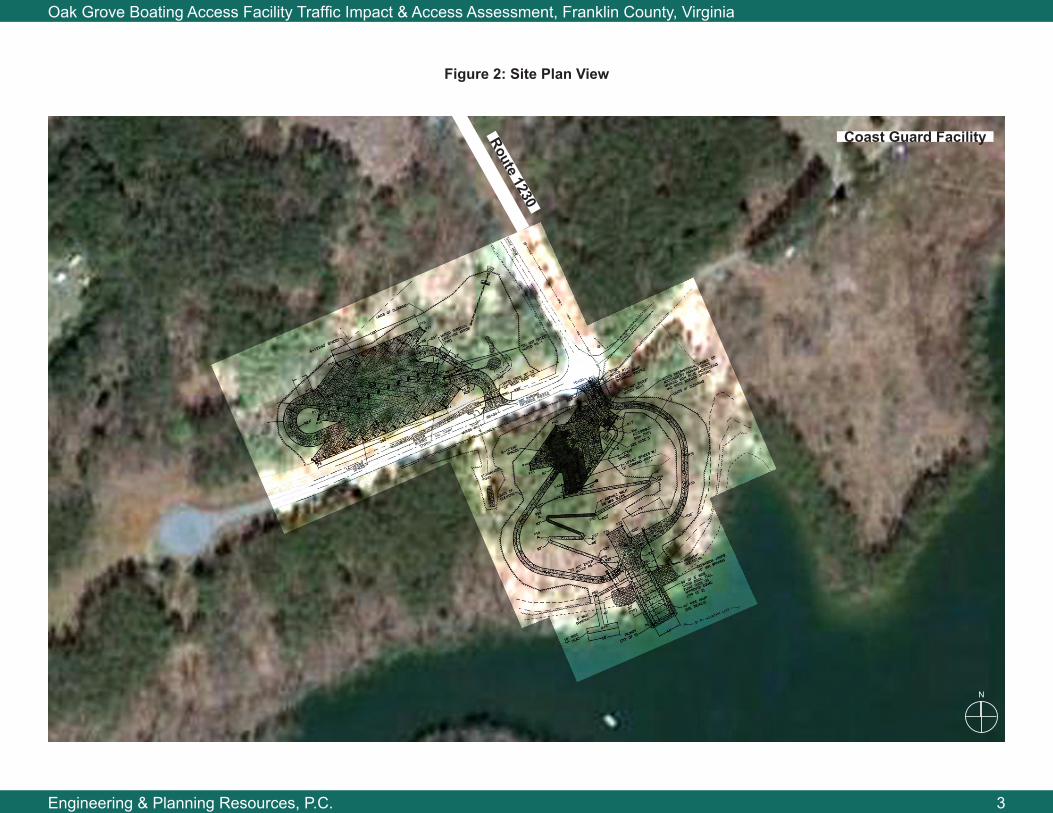
Figure 2: Site Plan View
Route 1230
Coast Guard Facility
N

Oak Grove Boating Access Facility Traffic Impact & Access Assessment, Franklin County, Virginia
Engineering & Planning Resources, P.C. 4
Where is the site located?
The preceding Figures 1 and 2 provide illustrations of where the new boat access facility is proposed for construction. It is located at the end of Oak Grove Drive (Route 1230) and will be situated adjacent to the United States Coast Guard Facility, and eventually a new Smith Mountain Marine Volunteer Fire Department.

Oak Grove Boating Access Facility Traffic Impact & Access Assessment, Franklin County, Virginia
Engineering & Planning Resources, P.C. 5
How will the site be accessed from the main road system?
Access to the boat access facility and adjacent parking lot will be directly from Oak Grove Drive (Route 1230). Access to the second parking facility will be from either Oak Grove Drive, or from Oak Grove Court that extends off of the southern end of Oak Grove Drive (pending final site plan design).
The traffic routing from the nearest arterial type facility, Route 122, would be via Merriman Road (Route 666) to Oldfield Road (Route 978) and then Oak Grove Drive (Route 1230). See Figure 3 for a map of the road network leading into the site.

Oak Grove Boating Access Facility Traffic Impact & Access Assessment, Franklin County, Virginia
Engineering & Planning Resources, P.C. 6
Figure 3: Travel Routing to the Site
Route 666
Route 978
Route 1230
Project Site
Route 122
N

Oak Grove Boating Access Facility Traffic Impact & Access Assessment, Franklin County, Virginia
Engineering & Planning Resources, P.C. 7
Figure 4: Oak Grove Drive (Route 1230) (photo looking north from Oak Grove Court)
Figure 5: Oak Grove Drive (Route 1230) (photo looking towards the south
where the boat access facility entrance would be located)
Oak Grove Boating Access Facility Traffic Impact & Access Assessment, Franklin County, Virginia
Engineering & Planning Resources, P.C. 8
How much traffic will the boat access facility generate?
Trip generation for a particular site and use can be difficult to estimate. However, in this case, APCo had a study performed by an outside consultant that documents trip generation for several other boat access facilities around the lake. Using this data, we can begin to get a picture for how many daily trips, for both a weekday and weekend (in the summer months) we might expect.
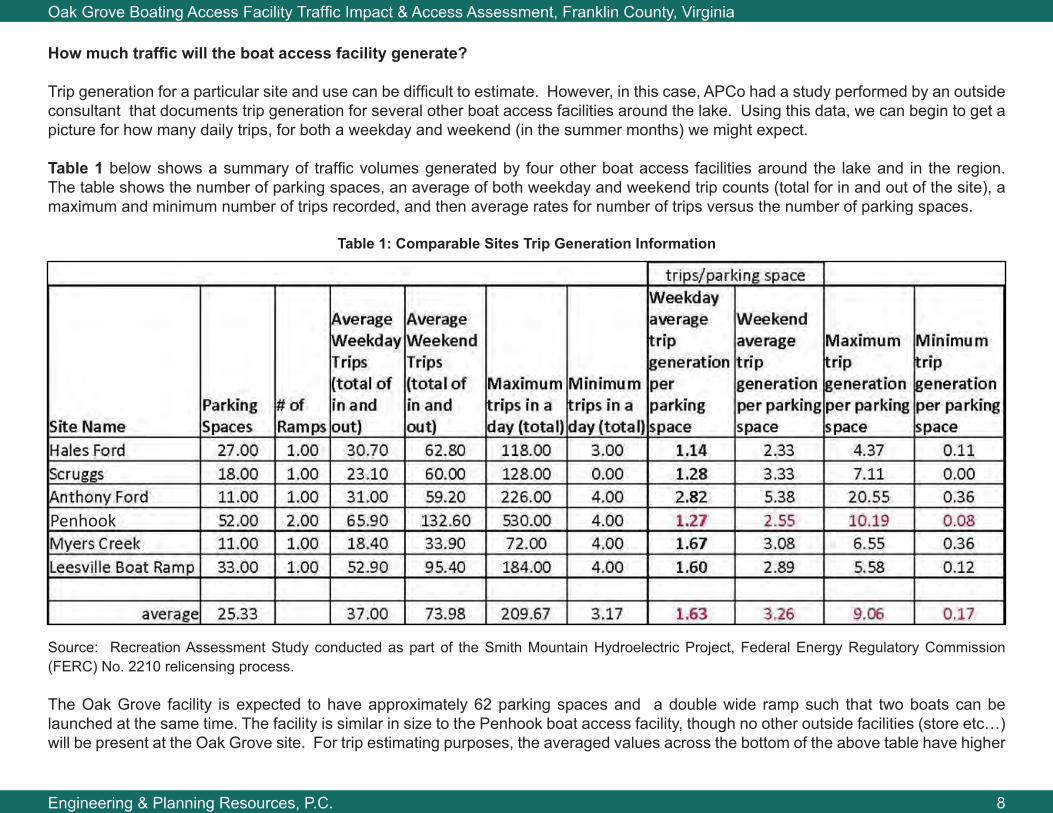
Table 1 below shows a summary of traffic volumes generated by four other boat access facilities around the lake and in the region. The table shows the number of parking spaces, an average of both weekday and weekend trip counts (total for in and out of the site), a maximum and minimum number of trips recorded, and then average rates for number of trips versus the number of parking spaces.
Table 1: Comparable Sites Trip Generation Information
Source: Recreation Assessment Study conducted as part of the Smith Mountain Hydroelectric Project, Federal Energy Regulatory Commission (FERC) No. 2210 relicensing process.
The Oak Grove facility is expected to have approximately 62 parking spaces and a double wide ramp such that two boats can be launched at the same time. The facility is similar in size to the Penhook boat access facility, though no other outside facilities (store etc…) will be present at the Oak Grove site. For trip estimating purposes, the averaged values across the bottom of the above table have higher
Penhook
Oak Grove Boating Access Facility Traffic Impact & Access Assessment, Franklin County, Virginia
Engineering & Planning Resources, P.C. 9
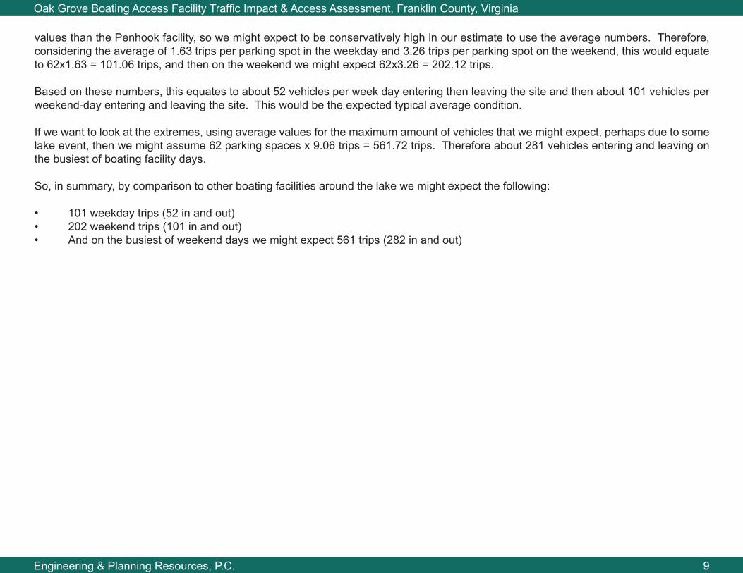
values than the Penhook facility, so we might expect to be conservatively high in our estimate to use the average numbers. Therefore, considering the average of 1.63 trips per parking spot in the weekday and 3.26 trips per parking spot on the weekend, this would equate to 62x1.63 = 101.06 trips, and then on the weekend we might expect 62x3.26 = 202.12 trips.
Based on these numbers, this equates to about 52 vehicles per week day entering then leaving the site and then about 101 vehicles per weekend-day entering and leaving the site. This would be the expected typical average condition.
If we want to look at the extremes, using average values for the maximum amount of vehicles that we might expect, perhaps due to some lake event, then we might assume 62 parking spaces x 9.06 trips = 561.72 trips. Therefore about 281 vehicles entering and leaving on the busiest of boating facility days.
So, in summary, by comparison to other boating facilities around the lake we might expect the following:
• 101 weekday trips (52 in and out)• 202 weekend trips (101 in and out)• And on the busiest of weekend days we might expect 561 trips (282 in and out)

Oak Grove Boating Access Facility Traffic Impact & Access Assessment, Franklin County, Virginia
Engineering & Planning Resources, P.C. 10
As a point of comparison, if the land were subdivided into residential lots per the R-1 zoning, how many vehicle trips would be expected?
The two parcels comprising the overall proposed boat access facility land are approximately nine and a half (9.5) acres total. Per the zoning regulations and ordinances, the minimum lot size could be 35,000 square feet. Therefore for the 9.5 acres there could be at least twelve (12) residential lots developed. The zoning code has additional stipulations for lesser lot widths when on the lake frontage, but for the sake of comparison we can use the by-right and therefore conservatively low estimate of twelve (12) lots. Typically, a residential house will generate an average of ten (10) trips a day which equates to five times leaving and returning to the house. Therefore, the by-right subdivided residential lot usage would be expected to be 120 trips per day (60 trips out and 60 return trips).
By comparison, the boat access facility would actually have less weekday daily trips, and therefore a lower average weekday daily traffic count, than the by-right residential use.

Oak Grove Boating Access Facility Traffic Impact & Access Assessment, Franklin County, Virginia
Engineering & Planning Resources, P.C. 11
How much traffic is on the roads leading into the site currently?
The Virginia Department of Transportation keeps records of how many vehicles travel the roadways that they maintain. This information can be found at www.virginiadot.org. By inspection of the year 2010 data, we see the following information about traffic volumes on Routes 1230, 978, 666, and 122. (See Figure 6 for illustration of the route locations)
• Route 1230 – 40 vehicles per day• Route 978 – 370 vehicles per day• Route 666 – 710 vehicles per day north of Oldfield Road (Route 978), and then the volume increases to 1100 vehicles per day north of Dovetail Road (Route 950)• Route 122 – 10,000 vehicles per day
Adding the new volumes when the boat access facility is constructed to the existing volumes, we might expect a near term total trip count to grow to around:
• Route 1230 – 142 vehicles per weekday, and 242 vehicles on a weekend day• Route 978 – 472 vehicles per weekday and 572 vehicles on a weekend day• Route 666 – 812 vehicles per weekday and 912 vehicles per weekend day (north of Route 978)• Route 122 – in sum total, the change in traffic on Route 122 would be minimal since folks are already trailering their boats to the boat access facility, but not currently turning at the Route 666 intersection. Therefore, this traffic is likely already on the road and is not newly generated traffic.
Note that additional increases in traffic will occur along Route 1230, 978, and 666 as the last of the residential parcels in the area build out. Again, a typical estimate of traffic per house is 10 trips per house per day. On Route 122, the traffic will continue to increase at a rate corresponding the growth in the regional traffic and growth in the nearby commercial/ retail development.

Oak Grove Boating Access Facility Traffic Impact & Access Assessment, Franklin County, Virginia
Engineering & Planning Resources, P.C. 12
Project Site
Figure 6: Traffic Volume Map
N
Route NumberLegend
XXX/XXX/XXXExisting/Future Weekday/Future Weekend day
Route 666 East of Route 950710/812/912
Route 978370/472/572
Route 123040/142/242
Route 666 Near Route 1221,100/1,202/1,302
Route 12210,000/10,000/10,000
Roads leading into the site Route 950 (Gravel)

Oak Grove Boating Access Facility Traffic Impact & Access Assessment, Franklin County, Virginia
Engineering & Planning Resources, P.C. 13
Are the roads built for the current volumes and also the future volumes if the boat facility is built?
To answer this question, we have to consider both the traffic volumes versus the roadway capacity, and also the physical features of the roadway. Both of these aspects are discussed in the following paragraphs.
Traffic Volumes
Overall, the traffic volumes are relatively low compared to what a two lane road can convey. Each of the roads as previously noted have sufficient capacity for the extra volume of traffic that might be generated by the boat access facility. While there will be a noticeable difference in the traffic volumes and the composition of the traffic (i.e. trucks with trailers), the total future volume will not create congestion or significant delay at the intersections.
Pavement conditions
Oak Grove Drive (Route 1230) has what is often referred to as a tar and chip surface. This means that it used to be a gravel road but at some point VDOT sprayed tar and added small gravels (chips) on top of the tar to make a more stable surface. Tar and chip surfacing provides a stable surface without the expense of constructing full depth pavement. However, without a full depth pavement structure, the road is currently, and will continue to, experience settling and rutting along the edges.
Trailered boats are often not heavier than today’s trucks and cars. Weights of trucks and cars typically range from 3000 pounds (compact cars) to 6000 pounds (pickup trucks and sport utility vehicles). That weight is distributed to the road via four tires, therefore each tire transmits between around 800 lbs to 1500 lbs of weight to the roadway. Trailers for smaller boats often use two tires and the trailers for larger boats use four and sometimes six tires. By comparison, the overall loads per tire between the cars/trucks and boat trailers is not signicantly different. Therefore, whether it the traffic is from cars/trucks, or trucks with trailers, the pavement will hold up similarly. However, it is the increase in traffic that has the largest effect on pavement life.
It is suggested, however, that the road will need to be upgraded to a more typical residential type road pavement structure in the future, regardless of whether the development that occurs is the boat access facility or the potential by-right residential development. The GS-4 design criteria from VDOT’s road design manual (Table 2) would apply. Pavement widths would be the same as they are currently, though there could be a need to re-work the shoulders if in a cut or fill environment.
Pavement Width
The existing roadways were recently measured and were found to be approximately 18’ in width. Route 666 widens out to around 20’ in width on the north end near Route 122. In most states, the widest trailer that can be towed without a special permit is eight and a half (8.5) feet in width. Most trailers for boats used in a lake environment are eight (8) feet wide or less.

Oak Grove Boating Access Facility Traffic Impact & Access Assessment, Franklin County, Virginia
Engineering & Planning Resources, P.C. 14
Requirements for permits for hauling trailers wider than eight and a half (8.5) feet can be found at the website https://www.dmv.virginia.gov/apps/vahps/vahps_home.aspx.
Therefore, nine (9) foot lanes will provide sufficient room for two eight (8), or even eight and a half (8.5) foot wide trailers to pass without making contact. Granted, they will need to pass slowly and/or utilize the shoulder area to a small degree.
Table 2: Excerpt From VDOT Road Design Manual

Oak Grove Boating Access Facility Traffic Impact & Access Assessment, Franklin County, Virginia
Engineering & Planning Resources, P.C. 15
Figure 7: Evidence of existing pavement failure and rutting(along Oak Grove Drive)
Figure 8: Oldfield Road (Route 978) Typical Section (posted 25MPH)

Oak Grove Boating Access Facility Traffic Impact & Access Assessment, Franklin County, Virginia
Engineering & Planning Resources, P.C. 16
Are there examples of other roads leading to boat access facilities that are of similar widths?
A limited investigation was performed to see if there were other examples of roads of similar widths serving boat access facilities. The results of the field review, as conducted by APCo, are as shown below in Table 3.
Table 3: Comparison of pavement widths at other boat access facilities
Boat Ramp/Zoning Location/County Pavement Width Other Characteristics
Scruggs/R-1 Dudley Amos Road/Franklin 16’Dudley Amos = approx 2 miles;
Dudley Amos = heavily developed with residential homes;
Hales Ford/R-2 Medium Residential Meadow Point Drive/Bedford 20’
1,727 feet from Timberwood Lane;2 miles from Hendricks Store Road;
In the middle of a subdivision;
Anthony Ford Hardy Road/Pittsylvania CountyWithin site =15’ 2”
Outside @ Hardy Court and Hardy Road = 17’ 2”
Rural residential;
Oak Grove/R-1
SW of intersection with Woodbrook Drive 19’
Few existing houses along Oak Grove.
640 Oldfield 18’ 4”
100 Oak Grove 17’ (or 18’ if add a small area of ungrassed gravel area)
25’ away from split rail fence towards the proposed Oak Grove Boating Access Facility 15’
Oak Grove Boating Access Facility Traffic Impact & Access Assessment, Franklin County, Virginia
Engineering & Planning Resources, P.C. 17
If the road is to be improved, is there a funding source for that effort?
There is a grant program for improving access to recreational facilities. Because the facility would become part of the Department of Game and Inland Fisheries (DGIF) facilities, there is a potential that Virginia Recreational Access Funds could be tapped for improving access, which would include upgrading the roadway. VDOT and Franklin County would need to collaborate with DGIF to work through the funding and road acceptance process.

Oak Grove Boating Access Facility Traffic Impact & Access Assessment, Franklin County, Virginia
Engineering & Planning Resources, P.C. 18
Would VDOT take Oak Grove Court into their maintenance system?
Oak Grove Drive is already a state maintained roadway and has a state route number. However, Oak Grove Court is a private cul-de-sac roadway. If the entrance to the parking lot connects to Oak Grove Court, then, if the road is upgraded to the current VDOT standards to the point of connection with the parking lot entrance, then VDOT would likely accept the road into their system.
Oak Grove Boating Access Facility Traffic Impact & Access Assessment, Franklin County, Virginia
Engineering & Planning Resources, P.C. 19
What about the intersections leading in from Route 122, can they safely accomodate the cars / trucks with trailers?
Short answer is yes – the intersections have sufficient turning radii available to the trailers to make the turn. The following Figures 9 and 10 illustrate a turning template as applied to aerial photography that demonstrates that this traffic can safely make the required turns.
Based on field observations, it appears that there is sufficient sight distance for the Oldfield Road (Route 978) / Oak Grove Drive (Route 1230), Merriman Way / Oldfield Road (Route 978), and Merriman Way Road (Route 666) / Route 122 intersections. However, at Merriman Way Road (Route 666) / Route 122, for vehicles leaving Merriman Way Road (Route 666) and looking to the left there is a vertical curve (gentle hill) that does somewhat restrict the sight distance. This should be looked at using field survey equipment to verify the sight distance. The current speed posting on Route 122 is 55 MPH, though to both the east and west there are 45 MPH zones. It might be advisable to conduct a speed study to verify that 55 MPH is still appropriate given the new commercial development, and potential new trailered boat turning traffic in the vicinity.
Also, additional followup investigation may be needed to check to see if a left and/or right turn lane might be warranted at the Merriman Way / Route 122 intersection. This will require gathering peak hour turning movement counts in both the AM and PM peak periods of the day, then comparing of those results to the VDOT turn lane warrant forms. Based on the crash history data as provided by VDOT, there is no history of crashes – in the past three years- occurring at this intersection.

Oak Grove Boating Access Facility Traffic Impact & Access Assessment, Franklin County, Virginia
Engineering & Planning Resources, P.C. 20
Figure 9: Turning Radius Analysis at Merriman Way Rd (Route 666) and Oldfield Road
Figure 10: Turning Radius Analysis at Route 122 and Merriman Way Rd (Route 666)
Oldfield Road
(Route 978)
Merrim
an Way Road
(Route 666)
Merriman Way Road(Route 666)
Rout
e 12
2
N
N

Oak Grove Boating Access Facility Traffic Impact & Access Assessment, Franklin County, Virginia
Engineering & Planning Resources, P.C. 21
Is there any documented safety/crash history for the intersections that would indicate an unsafe condition for adding boat trailers to the mix of traffic?
The crash history for the prior three years was requested from VDOT and reviewed. Over the past three years there have only been two crashes on the road network between the proposed site location and Route 122. In both cases the crashes involved only vehicle and both were run-off-the road crashes, one of which was due to icy road conditions.

Oak Grove Boating Access Facility Traffic Impact & Access Assessment, Franklin County, Virginia
Engineering & Planning Resources, P.C. 22
Will boaters be able to find the facility without getting lost in our residential neighborhoods?
Proper signing to the boat access facility will be required from Route 122 following the travel path to the boat access facility. The signing should start at Route 122 / 666 intersection and be provided at all intersection leading to the site. There was concern for making sure that boaters will know to make the right from Oldfield Road onto Oak Grove Drive. This would be an important place for a prominent sign for both the boat ramp, and also perhaps an additional sign and landscaping that would serve as a strong visual queue and an entry treatment for the neighborhood. The Virginia Department of Game and Inland Fisheries will provide trailblazer signs from the main highways to the boat access facility, including at all of the intersections along the travel path.
Figure 11: Oldfield Road / Oak Grove Drive Intersection

Oak Grove Boating Access Facility Traffic Impact & Access Assessment, Franklin County, Virginia
Engineering & Planning Resources, P.C. 23
Figure 12 shows an example, schematically, of how this could be configured.
Figure 12: Signage & Entry Treatment
Community Entry Landscape (by others)
Trailblazer Signage indicating the way to the Site
N

Oak Grove Boating Access Facility Traffic Impact & Access Assessment, Franklin County, Virginia
Engineering & Planning Resources, P.C. 24
In summary, what will need to be addressed in terms of road and traffic improvements?
Based on the research and analyses conducted for this effort and as summarized within, it appears that the road system is generally sufficient to handle the additional traffic loading that would be expected by the new boat access facility. However, the following additional efforts may be required in the future:
1. Conduct a turn lane warrant study at the Merriman Way (Route 666) and Route 122 intersection. This need may currently exist without the increment of additional traffic associated with the proposed boat access facility.2. Provide adequate signage for wayfinding to the boat access facility, then back out to Route 122.3. Consider working with the neighborhood to the northeast of the Oak Grove Drive (Route 1230) intersection to identify a landscaping and entry treatment plan that would help to clearly communicate that the boat access facility traffic is to make a right turn onto Oak Grove Drive (and not enter into the neighborhood).4. Work with VDOT to check about re-evaluating the current posted speed on Route 122 near the Merriman Way Road (Route 666) intersection. 5. It would be advisable to perform a speed study on Merriman Way Road (Route 666) since it is currently not posted, thus has a default speed limit of 55 mph.6. Pursue Virginia Recreational Access Funds for improving Oak Grove Drive (Route 1230) to a full 18’ width and full depth pavement per VDOT GS - 4 design criteria.
Figure 13: Leaving Merriman Way looking to the right along Route 122
Oak Grove Boating Access Facility Traffic Impact & Access Assessment, Franklin County, Virginia
Engineering & Planning Resources, P.C. 25
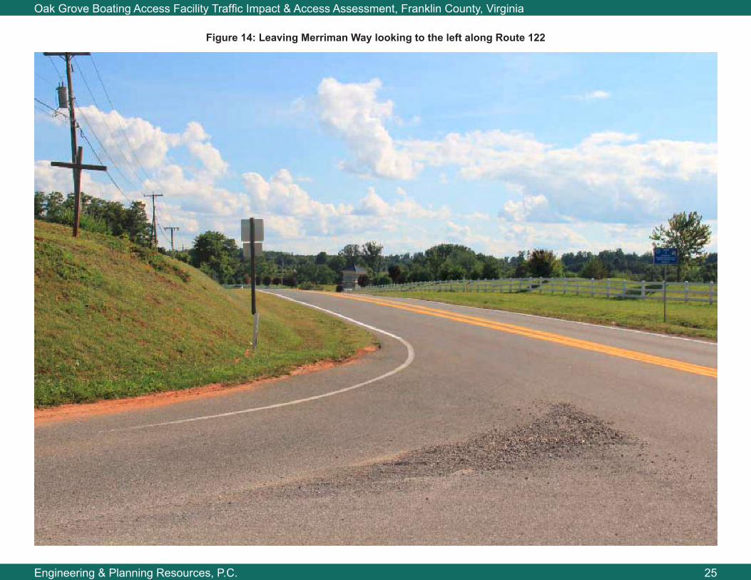
Figure 14: Leaving Merriman Way looking to the left along Route 122