situation update flooding in thailand - 11 october 2011
TRANSCRIPT
8/3/2019 Situation Update Flooding in Thailand - 11 October 2011
http://slidepdf.com/reader/full/situation-update-flooding-in-thailand-11-october-2011 1/11
Situation Update: Flooding in Thailand
Updated 11 October 2011By International Public Relations Division, Tourism Authority of Thailand
Over the past several weeks, seasonal rains that are heavier than usual have resulted inwidespread flooding in Thailand. While the flooding is having some impact on tourism, keytourist destinations and attractions throughout Thailand have not been affected by thefloods and most remain open. The floods are mainly affecting the provinces in central,north and northeast Thailand. Provinces in the south have not been affected by the floods.
Major tourist destinations such as Bangkok, Chiang Mai, Chiang Rai, Lampang, Sukhothai,Kanchanaburi, Ratchburi, Pattaya, Ko Chang, Rayong, Phuket, Krabi, Trang, Ko Samui,and all provinces in southern Thailand are experiencing normal weather conditions. Allairports throughout Thailand, including Suvarnabhumi Airport in Bangkok, have not been
affected by the floods and are operating as per usual.
Tourists can call the TAT Information Line at 1672 to check local conditions, or visit theThailand Meteorological Department web site at http://www.tmd.go.th/en for updatedweather forecasts.
1. Update for Bangkok
The areas of central Bangkok where tourists normally go are not flooded and fully
accessible. Everything continues as normal for both visitors and Bangkok residents inthese areas.
Most of the flooding now taking place is in provinces to the north and east of Bangkok.Almost all of the Bangkok Metropolitan Area is protected by a large network of flood walls,levees, canals and drainage tunnels. The city government is using this network to managethe water flow and minimize flooding in the city.
Some outlying suburban districts of the Bangkok Metropolitan Area outside of these flooddefenses could face flooding if the current situation continues. During periods of intenselyheavy rain, there is some localized flooding of certain low-lying streets in Bangkok. These
conditions are quickly cleared up by municipal work crews and the city's storm waterdrainage system.
The Chao Phaya river, which runs through Bangkok, is at a higher-than-normal level withsome localised flooding along certain sections of its banks. The river's water flow is beingcarefully managed by government officials to prevent broader flooding. The area aroundSuvarnabhumi Airport has considerable flood protection measures in place. The airporthas not been affected by floods and continues to operate normally.
Visitors can check water levels in each district of Bangkok at the Royal IrrigationDepartment: http://dds.bangkok.go.th/scada
8/3/2019 Situation Update Flooding in Thailand - 11 October 2011
http://slidepdf.com/reader/full/situation-update-flooding-in-thailand-11-october-2011 2/11
2. Update for Ayutthaya
The Thai province of Ayutthaya has been widely affected by the floods. This includes
Ayutthaya's inner city island and world heritage sites. Tourist attractions on and outside the
island of Ayutthaya have been temporarily closed due to the floods. Due to the disruptionscaused by the floods, the TAT recommends that tourists avoid visiting Ayutthaya until the
flood water subsides and tourist attractions have reopened.
The following roads should be avoided as some sections are closed due to
flooding:
Highway 32, also known as The Asian Highway (AH-2), Km 21 to Km 39
Highway 3263 - route to the city center
Highway 3412 Bang Ban – Pak Hai Road
Highway 356 Road to Wat Satue
Road in front of Krungsri River Hotel - Wat Tham Niyom
Road to Wat Chai Wattanaram
Road to Ayothaya Floating Market and Wat Mahe Yong
Road to Amphoe Nakorn Luang
Wat Phra Yat Intersection
Visitors should use alternate routes, such as:
Highway 32, The Asian Highway (AH-2), from Pratunam Phra In to Ayutthaya CityHall
Highway 9
Highway 3111 Sam Khok – Bang Ban
Highway 340 Suphan Buri - Ayutthaya
Highway 347
Tourists who would like to visit cultural attractions can consider Sukhothai Historical Park
in Sukhothai, which is accessible via airplane (Bangkok Airways, which flies from
Suvarnabhumi to Sukhothai Airport), and from Bangkok via road through Bang Bua Thong – Suphan Buri – Chai Nat – Nakhon Sawan – Phichit – Phitsanulok – Sukhothai.
Tourists who would like to visit floating markets can go to Damnoen Saduak Floating
Marketing in Ratchaburi, which is open every day between 6.00 -12.00 hrs, and only two
hours by car from Bangkok. On the weekend, visitors can go to Amphawa Floating Market
in Samut Songkhram, which is open from 16:00 hours.
8/3/2019 Situation Update Flooding in Thailand - 11 October 2011
http://slidepdf.com/reader/full/situation-update-flooding-in-thailand-11-october-2011 3/11
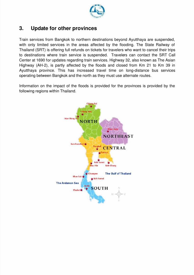
3. Update for other provinces
Train services from Bangkok to northern destinations beyond Ayutthaya are suspended,
with only limited services in the areas affected by the flooding. The State Railway of
Thailand (SRT) is offering full refunds on tickets for travelers who want to cancel their trips
to destinations where train service is suspended. Travelers can contact the SRT Call
Center at 1690 for updates regarding train services. Highway 32, also known as The Asian
Highway (AH-2), is partly affected by the floods and closed from Km 21 to Km 39 in
Ayutthaya province. This has increased travel time on long-distance bus services
operating between Bangkok and the north as they must use alternate routes.
Information on the impact of the floods is provided for the provinces is provided by the
following regions within Thailand.
8/3/2019 Situation Update Flooding in Thailand - 11 October 2011
http://slidepdf.com/reader/full/situation-update-flooding-in-thailand-11-october-2011 4/11
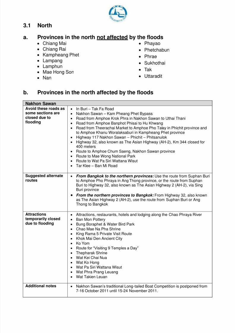
3.1 North
a. Provinces in the north not affected by the floods Chiang Mai
Chiang Rai
Kampheang Phet
Lampang Lamphun
Mae Hong Son
Nan
Phayao
Phetchabun
Phrae Sukhothai
Tak
Uttaradit b. Provinces in the north affected by the floods
Nakhon Sawan Avoid these roads assome sections are
closed due toflooding
In Buri – Tak Fa Road
Nakhon Sawan – Kam Pheang Phet Bypass
Road from Amphoe Krok Phra in Nakhon Sawan to Uthai Thani
Road from Amphoe Banphot Phisai to Hu Khwang
Road from Theerachai Market to Amphoe Pho Talay in Phichit province andto Amphoe Khanu Woralaksaburi in Kampheang Phet province
Highway 117 Nakhon Sawan – Phichit – Phitsanulok
Highway 32, also known as The Asian Highway (AH-2), Km 344 closed for400 meters
Route to Amphoe Chum Saeng, Nakhon Sawan province
Route to Mae Wong National Park
Route to Wat Pa Siri Wattana Wisut
Tar Klee – Ban Mi Road
Suggested alternateroutes
From Bangkok to the northern provinces: Use the route from Suphan Burito Amphoe Pho Phraya in Ang Thong province, or the route from SuphanBuri to Highway 32, also known as The Asian Highway 2 (AH-2), via SingBuri province
From the northern provinces to Bangkok: From Highway 32, also knownas The Asian Highway 2 (AH-2), use the route from Suphan Buri or AngThong to Bangkok
Attractionstemporarily closeddue to flooding
Attractions, restaurants, hotels and lodging along the Chao Phraya River
Ban Mon Pottery
Bung Boraphet & Water Bird Park
Chao Mae Na Pha Shrine
King Rama 5 Private Visit Route Khok Mai Den Ancient City
Ko Yom
Route for “Visiting 9 Temples a Day”
Thepharak Shrine
Wat Kei Chai Nua
Wat Ko Hong
Wat Pa Siri Wattana Wisut
Wat Phra Prang Leuang
Wat Takien Leuan
Additional notes Nakhon Sawan’s traditional Long-tailed Boat Competition is postponed from
7-16 October 2011 until 15-24 November 2011.
8/3/2019 Situation Update Flooding in Thailand - 11 October 2011
http://slidepdf.com/reader/full/situation-update-flooding-in-thailand-11-october-2011 5/11
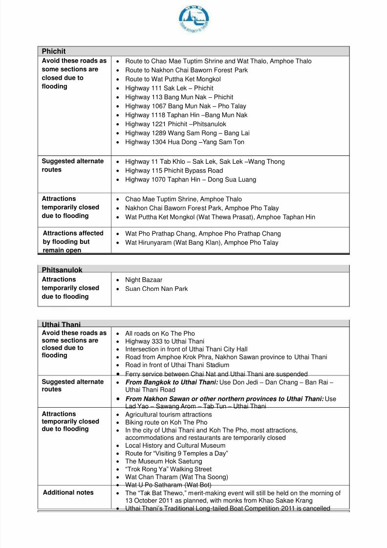
Phichit
Avoid these roads as
some sections are
closed due to
flooding
Route to Chao Mae Tuptim Shrine and Wat Thalo, Amphoe Thalo
Route to Nakhon Chai Baworn Forest Park
Route to Wat Puttha Ket Mongkol
Highway 111 Sak Lek – Phichit
Highway 113 Bang Mun Nak – Phichit Highway 1067 Bang Mun Nak – Pho Talay
Highway 1118 Taphan Hin –Bang Mun Nak
Highway 1221 Phichit –Phitsanulok
Highway 1289 Wang Sam Rong – Bang Lai
Highway 1304 Hua Dong –Yang Sam Ton
Suggested alternate
routes
Highway 11 Tab Khlo – Sak Lek, Sak Lek –Wang Thong
Highway 115 Phichit Bypass Road
Highway 1070 Taphan Hin – Dong Sua Luang
Attractions
temporarily closed
due to flooding
Chao Mae Tuptim Shrine, Amphoe Thalo
Nakhon Chai Baworn Forest Park, Amphoe Pho Talay
Wat Puttha Ket Mongkol (Wat Thewa Prasat), Amphoe Taphan Hin
Attractions affected
by flooding but
remain open
Wat Pho Prathap Chang, Amphoe Pho Prathap Chang
Wat Hirunyaram (Wat Bang Klan), Amphoe Pho Talay
Phitsanulok
Attractions
temporarily closeddue to flooding
Night Bazaar
Suan Chom Nan Park
Uthai Thani Avoid these roads assome sections areclosed due toflooding
All roads on Ko The Pho
Highway 333 to Uthai Thani
Intersection in front of Uthai Thani City Hall
Road from Amphoe Krok Phra, Nakhon Sawan province to Uthai Thani
Road in front of Uthai Thani Stadium
Ferry service between Chai Nat and Uthai Thani are suspended
Suggested alternateroutes
From Bangkok to Uthai Thani: Use Don Jedi – Dan Chang – Ban Rai – Uthai Thani Road
From Nakhon Sawan or other northern provinces to Uthai Thani: UseLad Yao – Sawang Arom – Tab Tun – Uthai Thani
Attractionstemporarily closeddue to flooding
Agricultural tourism attractions
Biking route on Koh The Pho
In the city of Uthai Thani and Koh The Pho, most attractions,accommodations and restaurants are temporarily closed
Local History and Cultural Museum
Route for “Visiting 9 Temples a Day”
The Museum Hok Saetung
“Trok Rong Ya” Walking Street
Wat Chan Tharam (Wat Tha Soong) Wat U Po Satharam (Wat Bot)
Additional notes The “Tak Bat Thewo,” merit-making event will still be held on the morning of13 October 2011 as planned, with monks from Khao Sakae Krang
Uthai Thani’s Traditional Long-tailed Boat Competition 2011 is cancelled
8/3/2019 Situation Update Flooding in Thailand - 11 October 2011
http://slidepdf.com/reader/full/situation-update-flooding-in-thailand-11-october-2011 6/11
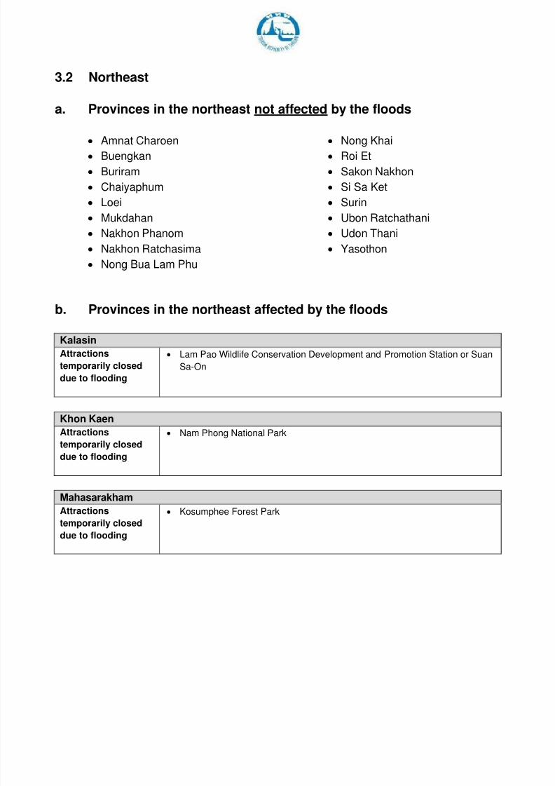
3.2 Northeast
a. Provinces in the northeast not affected by the floods
Amnat Charoen
Buengkan
Buriram
Chaiyaphum
Loei
Mukdahan
Nakhon Phanom
Nakhon Ratchasima
Nong Bua Lam Phu
Nong Khai
Roi Et
Sakon Nakhon
Si Sa Ket
Surin
Ubon Ratchathani
Udon Thani
Yasothon
b. Provinces in the northeast affected by the floods
Kalasin
Attractions
temporarily closed
due to flooding
Lam Pao Wildlife Conservation Development and Promotion Station or Suan
Sa-On
Khon Kaen
Attractions
temporarily closed
due to flooding
Nam Phong National Park
Mahasarakham
Attractions
temporarily closed
due to flooding
Kosumphee Forest Park
8/3/2019 Situation Update Flooding in Thailand - 11 October 2011
http://slidepdf.com/reader/full/situation-update-flooding-in-thailand-11-october-2011 7/11
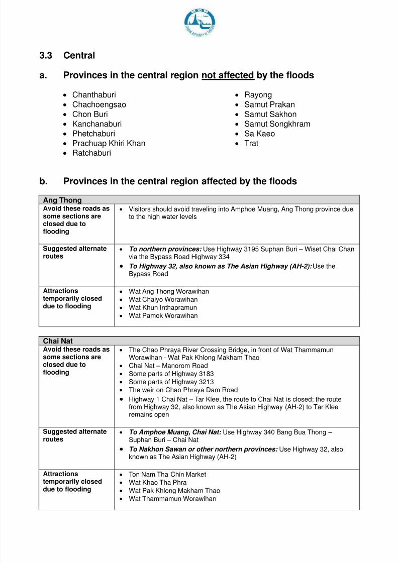
3.3 Central
a. Provinces in the central region not affected by the floods
Chanthaburi Chachoengsao
Chon Buri
Kanchanaburi
Phetchaburi
Prachuap Khiri Khan
Ratchaburi
Rayong Samut Prakan
Samut Sakhon
Samut Songkhram
Sa Kaeo
Trat
b. Provinces in the central region affected by the floods
Ang Thong Avoid these roads assome sections areclosed due toflooding
Visitors should avoid traveling into Amphoe Muang, Ang Thong province dueto the high water levels
Suggested alternateroutes
To northern provinces: Use Highway 3195 Suphan Buri – Wiset Chai Chanvia the Bypass Road Highway 334
To Highway 32, also known as The Asian Highway (AH-2): Use theBypass Road
Attractionstemporarily closeddue to flooding
Wat Ang Thong Worawihan
Wat Chaiyo Worawihan
Wat Khun Inthapramun
Wat Pamok Worawihan
Chai Nat Avoid these roads assome sections areclosed due toflooding
The Chao Phraya River Crossing Bridge, in front of Wat ThammamunWorawihan - Wat Pak Khlong Makham Thao
Chai Nat – Manorom Road
Some parts of Highway 3183
Some parts of Highway 3213
The weir on Chao Phraya Dam Road
Highway 1 Chai Nat – Tar Klee, the route to Chai Nat is closed; the routefrom Highway 32, also known as The Asian Highway (AH-2) to Tar Kleeremains open
Suggested alternateroutes
To Amphoe Muang, Chai Nat: Use Highway 340 Bang Bua Thong – Suphan Buri – Chai Nat
To Nakhon Sawan or other northern provinces: Use Highway 32, alsoknown as The Asian Highway (AH-2)
Attractionstemporarily closeddue to flooding
Ton Nam Tha Chin Market
Wat Khao Tha Phra
Wat Pak Khlong Makham Thao Wat Thammamun Worawihan
8/3/2019 Situation Update Flooding in Thailand - 11 October 2011
http://slidepdf.com/reader/full/situation-update-flooding-in-thailand-11-october-2011 8/11
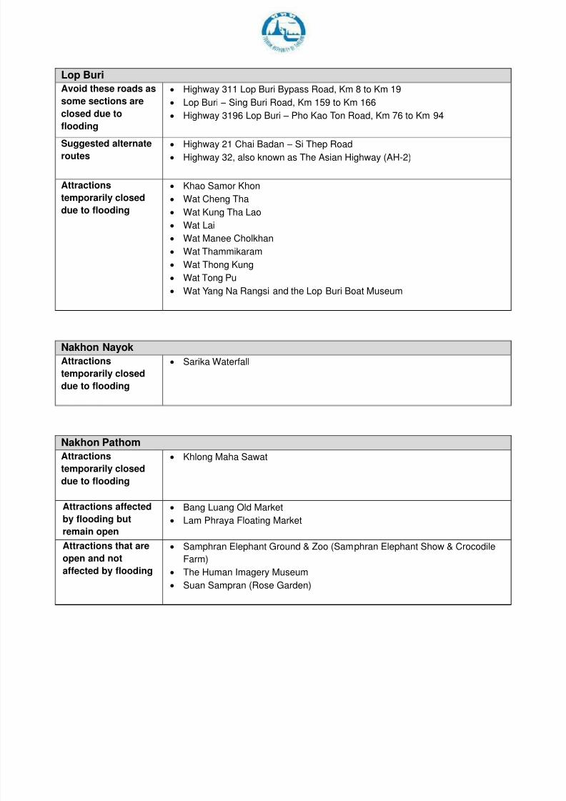
Lop Buri
Avoid these roads as
some sections are
closed due to
flooding
Highway 311 Lop Buri Bypass Road, Km 8 to Km 19
Lop Buri – Sing Buri Road, Km 159 to Km 166
Highway 3196 Lop Buri – Pho Kao Ton Road, Km 76 to Km 94
Suggested alternate
routes
Highway 21 Chai Badan – Si Thep Road
Highway 32, also known as The Asian Highway (AH-2)
Attractions
temporarily closed
due to flooding
Khao Samor Khon
Wat Cheng Tha
Wat Kung Tha Lao
Wat Lai
Wat Manee Cholkhan
Wat Thammikaram
Wat Thong Kung
Wat Tong Pu Wat Yang Na Rangsi and the Lop Buri Boat Museum
Nakhon Nayok
Attractions
temporarily closed
due to flooding
Sarika Waterfall
Nakhon Pathom
Attractions
temporarily closed
due to flooding
Khlong Maha Sawat
Attractions affected
by flooding but
remain open
Bang Luang Old Market
Lam Phraya Floating Market
Attractions that are
open and notaffected by flooding
Samphran Elephant Ground & Zoo (Samphran Elephant Show & Crocodile
Farm) The Human Imagery Museum
Suan Sampran (Rose Garden)
8/3/2019 Situation Update Flooding in Thailand - 11 October 2011
http://slidepdf.com/reader/full/situation-update-flooding-in-thailand-11-october-2011 9/11
Nonthaburi
Attractions
temporarily closed
due to flooding
Route for “Visiting 9 Temples a Day” by boat is closed for 1 month
Suan Kret Phutt
Wat Bangchak
Wat Choeng Lane
Wat Chim Phli Sutthawas Wat Klang Kret
Wat Sao Thong Tong
Wat Tha It
Attractions affected
by flooding but
remain open
Ko Kret
Wat Paramai Yikawat
Wat Phai Lom
Wat Yai Sawang Arom
Wat Sang Siri Tham
Pathum Thani
Attractions
temporarily closed
due to flooding
Ruean Phae Khao
Tao Ong Ang historical site (or Tao Sam Khok)
Wats / Temples along the east side of Chao Phraya River
Wat Bot, Sam Khok
Attractions that are
open and not
affected by flooding
Attractions in Rangsit and Thanya Buri
Prachin Buri
Attractions
temporarily closed
due to flooding
Prachin Buri National Museum
Saraburi
Avoid these roads as
some sections are
closed due to
flooding
Highway 1 (Phahonyothin Road), Km 107, Amnuay Songkram Bridge is
closed
Highway 3020 Phra Putthabat – Nong Don, Km 6 to Km 7
Highway 3034 Na Phra Lan –Cement plant at Ban Mor Road, Km14 to Km16
Highway 3224 Kaeng Khoi – Salang Phan, Km 9 to Km 10
Suggested alternate
routes
Highway 362 Saraburi West-Ring Road
Phra Putthabat – Ban Mor Road
Attractions
temporarily closed
due to flooding
Thai Yuan Cultural Study Centre
Attractions affected
by flooding but
remain open
Ban Ton Tan Floating Market
8/3/2019 Situation Update Flooding in Thailand - 11 October 2011
http://slidepdf.com/reader/full/situation-update-flooding-in-thailand-11-october-2011 10/11
Sing Buri
Avoid these roads as
some sections are
closed due to
flooding
Highway 309 Sing Buri – Ang Thong
Highway 311 Sing Buri – Chai Nat
Attractions
temporarily closed
due to flooding
In Buri National Museum
Pak Bang Market
Wat Amphawan
Wat Klang Thanarin
Wat Kudi Thong
Wat Muang
Wat Sutthawas
Suphan Buri
Avoid these roads as
some sections are
closed due to
flooding
Highway 340
Suggested alternate
routes
Highway 321
Highway 333
Attractions
temporarily closeddue to flooding
Wat Manao
Wat Pu Bua
Wat Pho Charoen
Wat Phrao
Wat Sam Pasiu
Wat Wora Chan
Kao Hong Market
Pho Phraya Market
8/3/2019 Situation Update Flooding in Thailand - 11 October 2011
http://slidepdf.com/reader/full/situation-update-flooding-in-thailand-11-october-2011 11/11