special heavy rain weather briefing 03/08/2012 srh.noaa/shv/briefing
DESCRIPTION
Special Heavy Rain Weather Briefing 03/08/2012 www.srh.noaa.gov/shv/briefing. Keith Stellman Warning Coordination Meteorologist. National Weather Service Shreveport, Louisiana. Overview. ** Significant Rainfall Event Setting up across the region ** Setup: - PowerPoint PPT PresentationTRANSCRIPT

Special Special Heavy Rain Heavy Rain Weather BriefingWeather Briefing
03/08/201203/08/2012
www.srh.noaa.gov/shv/briefingwww.srh.noaa.gov/shv/briefing
Keith StellmanKeith StellmanWarning Coordination Warning Coordination
MeteorologistMeteorologistNational Weather Service Shreveport, LouisianaNational Weather Service Shreveport, Louisiana

Overview****Significant Rainfall Event Setting up across the Significant Rainfall Event Setting up across the
regionregion****
Setup:Setup: Best Heavy Rainfall Setup since October 2009Best Heavy Rainfall Setup since October 2009 Stalled FrontStalled Front High Precipitable Water (99High Precipitable Water (99thth percentile) percentile) Cutoff upper level lowCutoff upper level low
ImpactsImpacts Flooding/Flash Flooding PossibleFlooding/Flash Flooding Possible
Thur PM->Friday AMThur PM->Friday AM Saturday -> SundaySaturday -> Sunday
Severe Weather Threat ThursdaySevere Weather Threat Thursday Damaging WindsDamaging Winds HailHail
National Weather Service Shreveport, LouisianaNational Weather Service Shreveport, Louisiana

Current Satellite/Water Current Satellite/Water VaporVapor
National Weather Service Shreveport, LouisianaNational Weather Service Shreveport, Louisiana
L Note the plume of moisture Note the plume of moisture from the Pacificfrom the Pacific
Cold Front dropping southCold Front dropping south

Radar @ 945Radar @ 945 Strong Strong
Storms Storms developingdeveloping
Expect Expect this area this area to fill as to fill as the day the day progressesprogresses

Thursday PMThursday PM Northern Northern
half of half of the areathe area
Along/ Along/ north I-north I-2020
1”- 1”- 3” ..isolat3” ..isolated 3” – ed 3” – 4”4”

Overnight ->Friday AMOvernight ->Friday AM
Southern Southern half of the half of the regionregion
Along/ Along/ south I-20south I-20
1”- 1”- 3” ..isolate3” ..isolated 3” – 4”d 3” – 4”

Precip Precip through through
Friday AMFriday AM Slight-> Slight->
ModeratModerate risk of e risk of excessivexcessive rainfall e rainfall i.e. Flash i.e. Flash FloodingFlooding
Excessive Rainfall Outlook

SPC slight risk area
SPC slight risk area
Severe Weather Threat – Thursday/Thursday PMSevere Weather Threat – Thursday/Thursday PM
Primary Threats:Primary Threats:1.1.Damaging WindsDamaging Winds2.2.HailHail3.3.Very isolated tornado threatVery isolated tornado threat

Friday-Friday NightFriday-Friday Night Front shifts Front shifts
southsouth
Break for Break for areas north areas north of I-20of I-20
Biggest Biggest threat area threat area Deep East Deep East TX-> coastTX-> coast

Friday PM – Saturday AMFriday PM – Saturday AM Rain begins Rain begins
re-re-developing developing SE TX SE TX coastcoast
Continued Continued break for break for areas north areas north of I-20of I-20
Biggest Biggest threat area threat area Deep East Deep East TX-> coastTX-> coast

Rainfall Forecast Rainfall Forecast Friday AM – Saturday AMFriday AM – Saturday AM
Heaviest Heaviest rainfall rainfall expected to expected to the south of the south of the regionthe region
May clip Deep May clip Deep East East TX/Central LA TX/Central LA with 1”-2”with 1”-2”

Saturday AM - Saturday Saturday AM - Saturday PMPM
Front Front aligns itself aligns itself north-> north-> south south across east across east TXTX
Rainfall Rainfall increasing increasing across East across East TXTX

Saturday PM – Sunday Saturday PM – Sunday AMAM
Heavy Heavy Rainfall Rainfall expected expected overnight overnight overspreadoverspreading the ing the entire entire region.region.
Heavy in Heavy in East TX / East TX / NW LA/ SW NW LA/ SW AR/ SE OKAR/ SE OK

Rainfall Forecast Rainfall Forecast Saturday AM – Sunday AMSaturday AM – Sunday AM
Heaviest Heaviest rainfall rainfall expected expected across western across western half along the half along the north/south north/south frontfront
1”- 3” ..isolated 1”- 3” ..isolated 3”-4”3”-4”

Sunday AM – Sunday PMSunday AM – Sunday PM Front Front
begins begins moving moving east with east with strong strong upper level upper level system system kicking outkicking out
Rainfall Rainfall increasing increasing across East across East TXTX
1”- 3” 1”- 3” possiblepossible

Sunday PM – Monday AMSunday PM – Monday AM Finally…Finally…
heavy rain heavy rain moving out moving out and ending and ending in the in the eastern eastern half of the half of the regionregion

Rainfall Forecast Rainfall Forecast Sunday AM – Monday AMSunday AM – Monday AM
Heaviest Heaviest rainfall rainfall expected expected across SW across SW AR/Western AR/Western LA/ Deep LA/ Deep East TXEast TX
1”- 3”1”- 3”

Computer Model Total Rainfall Computer Model Total Rainfall Forecast Forecast (ECMWF)(ECMWF)
Swath of 5”-Swath of 5”-7” 7” +extending +extending from Lufkin from Lufkin -> Marshall -> Marshall -> -> Texarkana /Texarkana /HopeHope

Computer Model Total Rainfall Computer Model Total Rainfall Forecast Forecast (GFS)(GFS)
Swath of 5”-Swath of 5”-6” East TX-6” East TX->NW LA->NW LA->SW AR>SW AR
Note the Note the consistency consistency in the in the location of location of the heavy the heavy rain axisrain axis

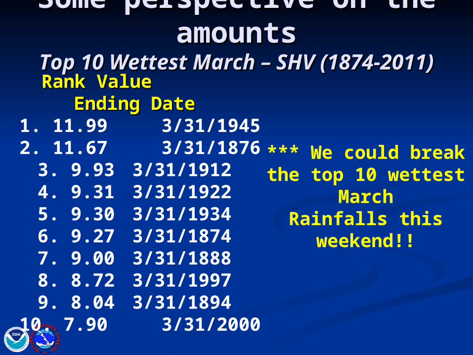
Some perspective on the Some perspective on the amountsamounts
Top 10 Wettest March – SHV Top 10 Wettest March – SHV (1874-2011)(1874-2011)Rank Value Rank Value
Ending Date Ending Date 1. 11.99 3/31/1945 2. 11.67 3/31/1876 3. 9.93 3/31/1912 4. 9.31 3/31/1922 5. 9.30 3/31/1934 6. 9.27 3/31/1874 7. 9.00 3/31/1888 8. 8.72 3/31/1997 9. 8.04 3/31/1894 10. 7.90 3/31/2000
*** We could break the top 10 wettest
MarchRainfalls this
weekend!!
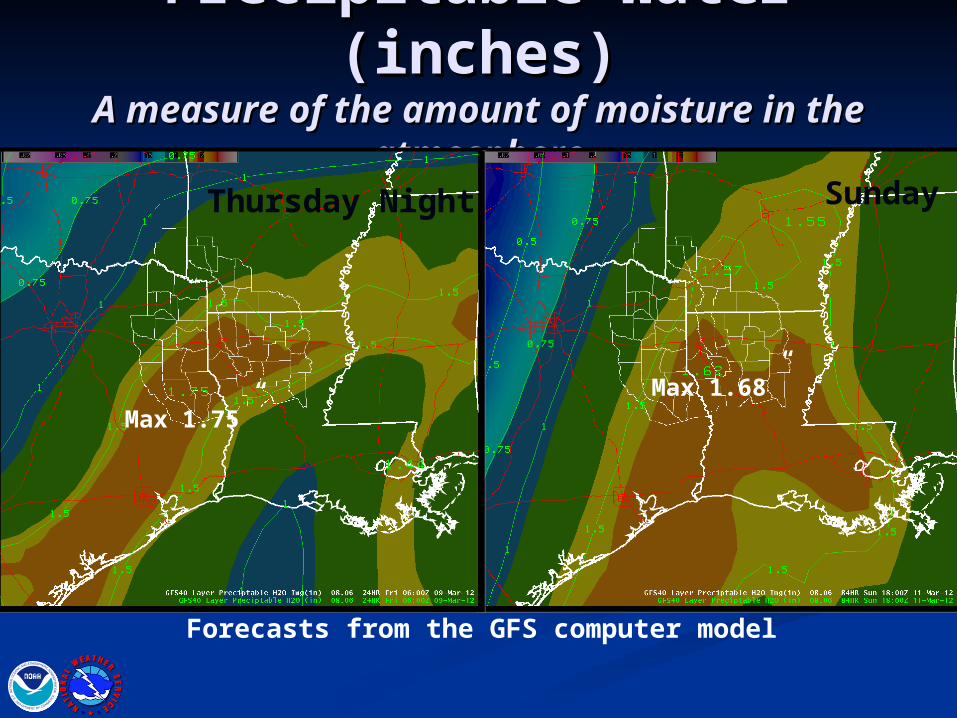
Precipitable Water (inches)Precipitable Water (inches)A measure of the amount of moisture in the A measure of the amount of moisture in the
atmosphereatmosphere
Max 1.75”Max 1.68”
Thursday Night Sunday
Forecasts from the GFS computer model

Climatology of Climatology of Precipitable WaterPrecipitable Water
X
This event falls inside the 99th percentile and approaches the maximum value observed in March..based on the forecast PW values

Impacts
National Weather Service Shreveport, LouisianaNational Weather Service Shreveport, Louisiana
River ImpactsRiver Impacts Sabine, Neches, Sulphur/ portions of the Red Sabine, Neches, Sulphur/ portions of the Red
system most at risk.system most at risk. Minor to some moderate flooding Minor to some moderate flooding
Depends on location of heaviest rainfall & Depends on location of heaviest rainfall & duration at which the rain fallsduration at which the rain falls
Other ImpactsOther Impacts Flooding/Flash Flooding PossibleFlooding/Flash Flooding Possible
Thur PM->Friday AMThur PM->Friday AM Saturday -> SundaySaturday -> Sunday
Severe Weather Threat ThursdaySevere Weather Threat Thursday Damaging WindsDamaging Winds HailHail

NEXT CONFERENCE CALL:
Possibly Friday 3/9 Time Possibly Friday 3/9 Time TBDTBD
www.srh.noaa.gov/shv/www.srh.noaa.gov/shv/briefingbriefing
National Weather Service Shreveport, LouisianaNational Weather Service Shreveport, Louisiana