severe weather briefing 11/21/2011 srh.noaa/shv/briefing
DESCRIPTION
Severe Weather Briefing 11/21/2011 www.srh.noaa.gov/shv/briefing. Keith Stellman Warning Coordination Meteorologist. National Weather Service Shreveport, Louisiana. Overview. This afternoon through tonight: Setup: Complicated Forecast! - PowerPoint PPT PresentationTRANSCRIPT
Severe Weather Severe Weather BriefingBriefing
11/21/201111/21/2011
www.srh.noaa.gov/shv/briefingwww.srh.noaa.gov/shv/briefing
Keith StellmanKeith StellmanWarning Coordination Warning Coordination
MeteorologistMeteorologistNational Weather Service Shreveport, LouisianaNational Weather Service Shreveport, Louisiana
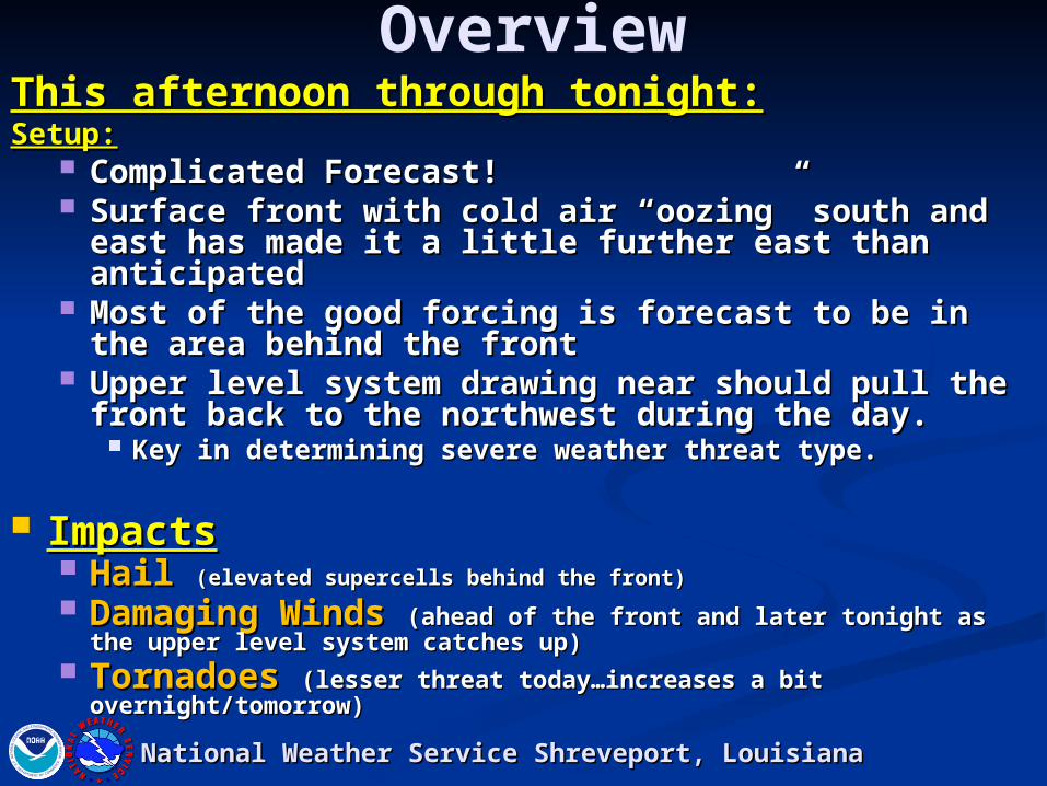
OverviewThis afternoon through tonight:This afternoon through tonight:Setup:Setup:
Complicated Forecast!Complicated Forecast! Surface front with cold air “oozing” south and Surface front with cold air “oozing” south and
east has made it a little further east than east has made it a little further east than anticipatedanticipated
Most of the good forcing is forecast to be in the Most of the good forcing is forecast to be in the area behind the frontarea behind the front
Upper level system drawing near should pull Upper level system drawing near should pull the front back to the northwest during the day.the front back to the northwest during the day.
Key in determining severe weather threat type.Key in determining severe weather threat type.
ImpactsImpacts HailHail (elevated supercells behind the front)(elevated supercells behind the front) Damaging Winds Damaging Winds (ahead of the front and later tonight (ahead of the front and later tonight
as the upper level system catches up)as the upper level system catches up) TornadoesTornadoes (lesser threat today…increases a bit (lesser threat today…increases a bit
overnight/tomorrow)overnight/tomorrow)National Weather Service Shreveport, LouisianaNational Weather Service Shreveport, Louisiana
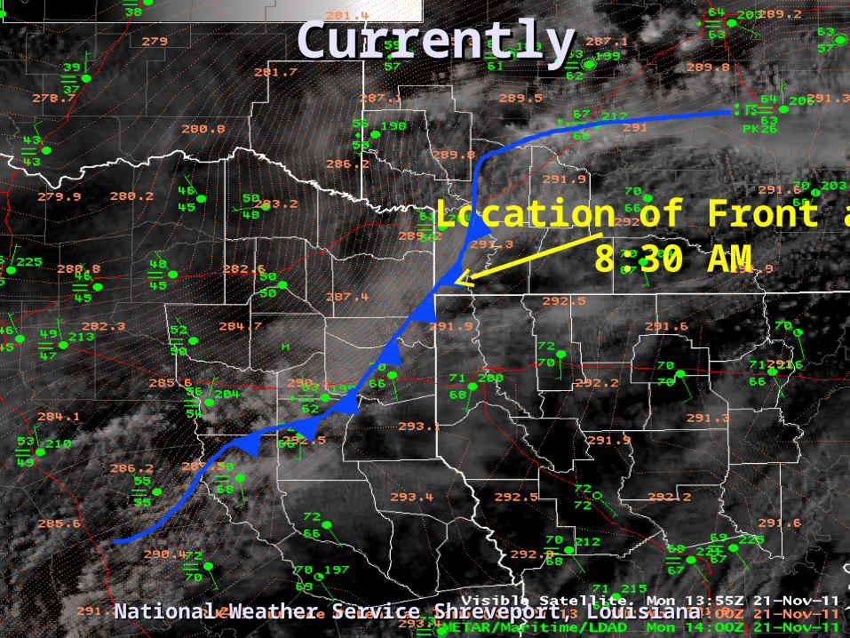
CurrentlyCurrently
National Weather Service Shreveport, LouisianaNational Weather Service Shreveport, Louisiana
Location of Front at 8:30 AM
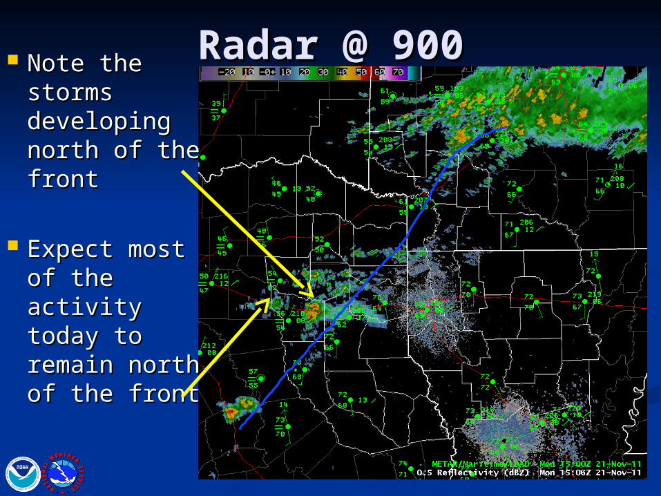
Radar @ 900Radar @ 900 Note the Note the storms storms developing developing north of the north of the frontfront
Expect most Expect most of the activity of the activity today to today to remain north remain north of the frontof the front
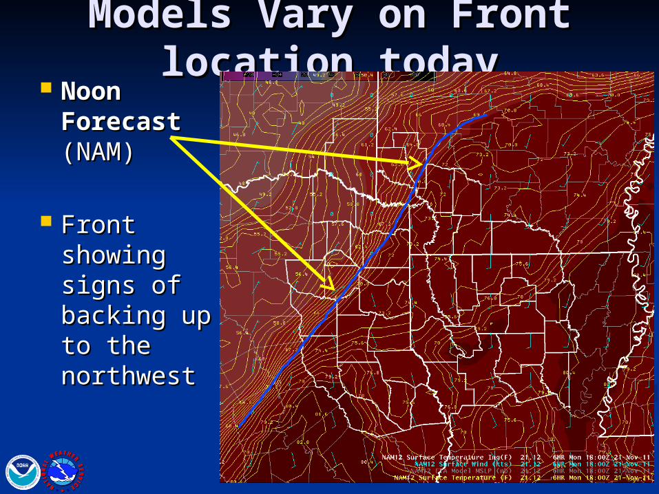
Models Vary on Front Models Vary on Front location todaylocation today
Noon Noon Forecast Forecast (NAM)(NAM)
Front Front showing showing signs of signs of backing up backing up to the to the northwestnorthwest
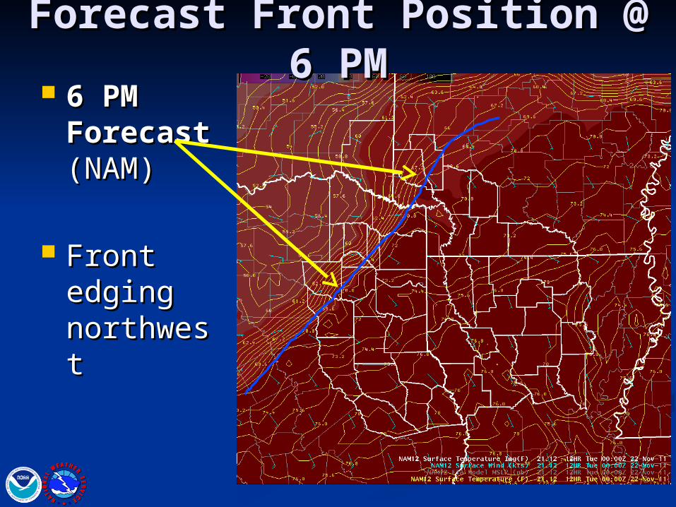
Forecast Front Position @ 6 Forecast Front Position @ 6 PMPM
6 PM 6 PM Forecast Forecast (NAM)(NAM)
Front Front edging edging northwestnorthwest
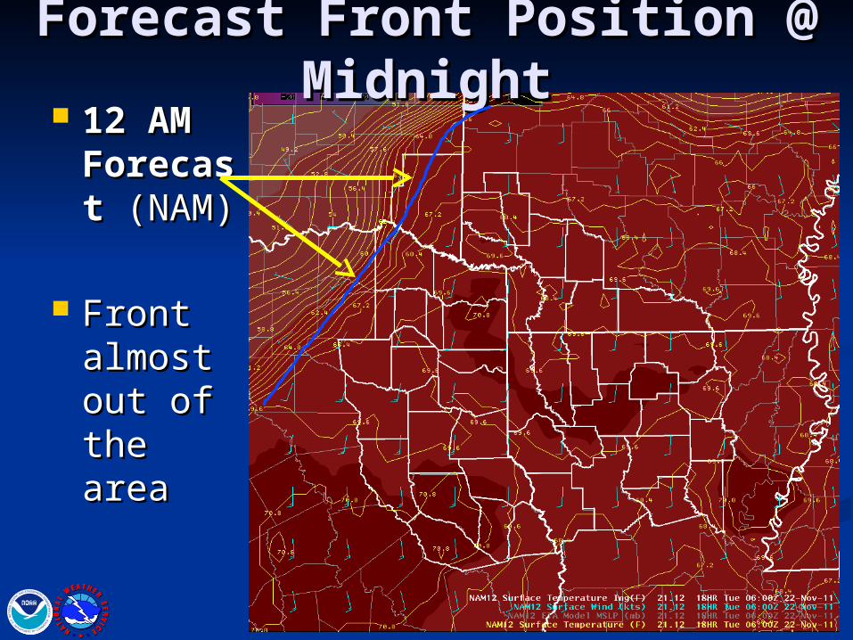
Forecast Front Position @ Forecast Front Position @ MidnightMidnight
12 AM 12 AM ForecasForecast t (NAM)(NAM)
Front Front almost almost out of out of the areathe area
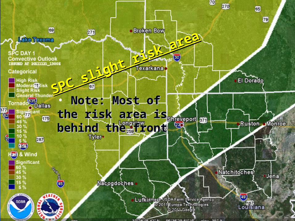
SPC slight risk area
SPC slight risk area
• Note: Most of the Note: Most of the risk area is behind risk area is behind the frontthe front
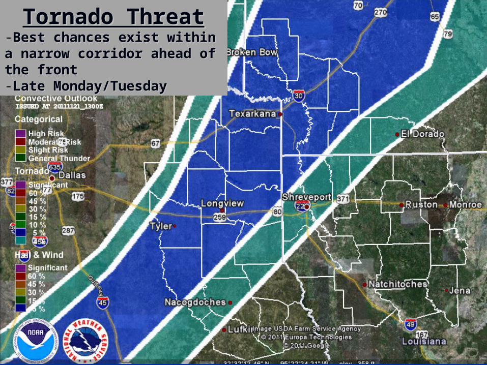
Tornado ThreatTornado Threat-Best chances exist within a Best chances exist within a narrow corridor ahead of narrow corridor ahead of the frontthe front-Late Monday/TuesdayLate Monday/Tuesday

Damaging Wind Damaging Wind -Best chances exist within a Best chances exist within a narrow along and ahead of narrow along and ahead of the frontthe front-Late Monday/TuesdayLate Monday/Tuesday
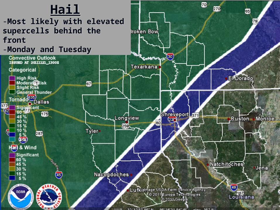
HailHail-Most likely with elevated Most likely with elevated supercells behind the frontsupercells behind the front-Monday and TuesdayMonday and Tuesday
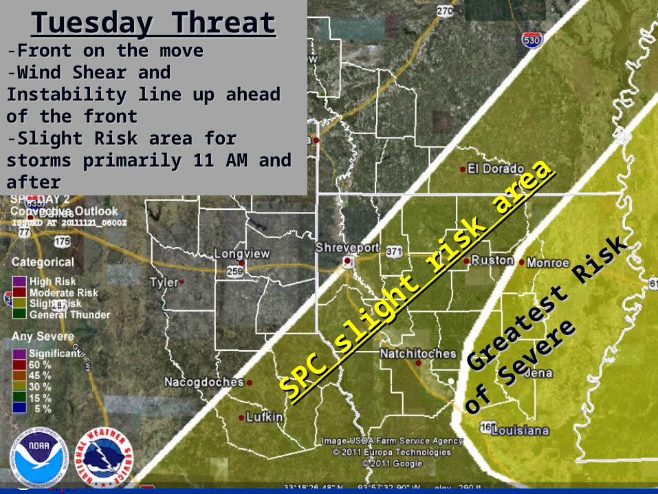
Tuesday ThreatTuesday Threat-Front on the moveFront on the move-Wind Shear and Instability Wind Shear and Instability line up ahead of the frontline up ahead of the front-Slight Risk area for storms Slight Risk area for storms primarily 11 AM and afterprimarily 11 AM and after
SPC slig
ht ris
k ar
ea
SPC slig
ht ris
k ar
ea
• Gre
ates
t Ris
k of
Great
est R
isk o
f
Sever
e
Sever
e

Computer Model Rainfall Computer Model Rainfall Forecast Forecast (GFS)(GFS)
Heaviest Heaviest behind the behind the frontfront
I-30 I-30 corridorcorridor
Less in Less in areas areas south and south and east of the east of the frontfront
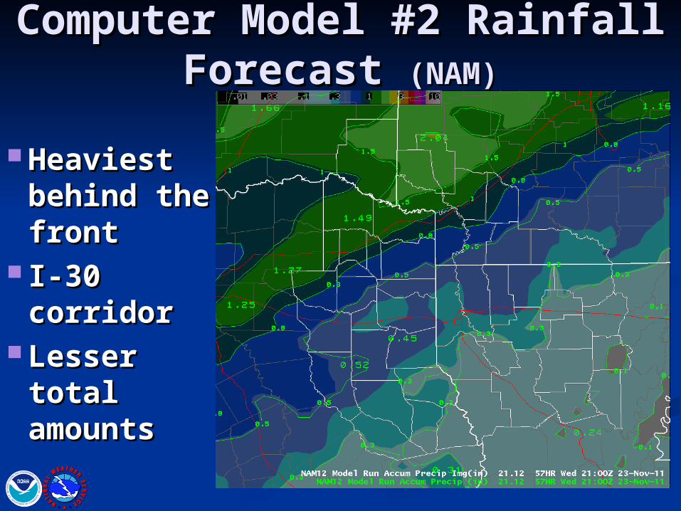
Computer Model #2 Computer Model #2 Rainfall Forecast Rainfall Forecast (NAM)(NAM)
Heaviest Heaviest behind the behind the frontfront
I-30 I-30 corridorcorridor
Lesser Lesser total total amountsamounts
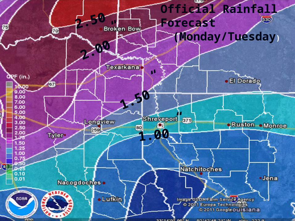
1.50”
Official Rainfall Forecast(Monday/Tuesday)
1.00”
2.00”2.50”
Summary This afternoon into tonight:This afternoon into tonight:
Complicated forecast due to surface frontComplicated forecast due to surface front Warm air riding over top of surface front…Warm air riding over top of surface front…
allowing storms to develop north of frontallowing storms to develop north of front Reduces overall tornado threatReduces overall tornado threat Increases hail threatIncreases hail threat
Greatest threats for tonight:Greatest threats for tonight:1.1.HailHail2.2.Damaging windsDamaging winds3.3.TornadoesTornadoes
**If the front can back up further…tornado **If the front can back up further…tornado threat increases across NE Texas/SW Arkansas threat increases across NE Texas/SW Arkansas late todaylate today
TuesdayTuesday Damaging Wind and tornado threat increasesDamaging Wind and tornado threat increases
Especially Eastern and Central LA during the Especially Eastern and Central LA during the afternoonafternoon
National Weather Service Shreveport, LouisianaNational Weather Service Shreveport, Louisiana
NEXT CONFERENCE CALL:
Wednesday 11/23 @ 10 Wednesday 11/23 @ 10 AMAM
www.srh.noaa.gov/shv/www.srh.noaa.gov/shv/briefingbriefing
National Weather Service Shreveport, LouisianaNational Weather Service Shreveport, Louisiana