subdivision in manitoba
TRANSCRIPT

Subdivision in ManitobaPlanning Resource Guide

Subdivision in ManitobaPLANNING RESOURCE GUIDE

Where do I start? You are in the right place. This guide provides all the necessary details to help you with your subdivision.
Subdividing land is a complicated process. There are various reasons why you might want to subdivide your property. However, there are numerous legal requirements that must be met so that your land rights and ownership are protected.
We recommend that you begin by talking with staff at the Community and Regional Planning office nearest you. They will be able to help you determine what types of subdivisions are permitted, what conditions may apply and other potential restrictions.
Don’t be afraid to ask questions. The more you know before you apply, the better prepared you will be to complete your subdivision. See page 68 for contact information.
For what you need to apply, see page 13.
For a quick description of the subdivision process, see pages 11-12.
For detailed information, see pages 13-21.
For FAQs, see pages 3-4.

Table of Contents
Part 1: SUBDIVISION BASICS FAQs 3 Terms Used in the Subdivision Process 5 Types of Subdivision 8
Part 2: SUBDIVISION PROCESS Steps in the Subdivision Process 11 Making a Subdivision Application 13 Application Form 15 Subdivision Application Map (SAM) 17 Status of Title 17 Review and Circulation 19 Decision 20 Conditional Approval 21
Part 3: SUBDIVISION REQUIREMENTS AND CONDITIONS Land Titles 25 Utilities 27 Municipal Conditions 29 Provincial Highways 31 Hazard Lands and Riparian Areas 35 Mineral Resources 39 Water and Waste Management 40 Drainage and Stormwater Management 45 Crown Lands and Provincial Parks 48 Agricultural Lands and Livestock 49 Historic Resources 51 Other Agency Requirements 53
Part 4: SUBDIVISION REGISTRATION CertificateofApprovalandRegistration 57 Summary of Essentials 58
Appendix: CommunityandRegionalPlanningOffices 68
Every effort has been made to ensure the accuracy of the information within this guide. In the event of a discrepancy between this guide and governing legislation or local bylaws, the legislation and bylaws will take precedence.


Subdivision BasicsPART 1

Subdividing land is complicated – even a one lot split. This guide will list the steps that you need to follow to complete your subdivision. Additional tips will also be provided to help you complete your subdivision more quickly.
What is a subdivision?A subdivision is the splitting of a parcel of land described on a certificate of title. A subdivision occurs when a single land title is split into two or more parts, property boundaries are rearranged, or a lease, mortgage or other instrument is registered that has the effect of subdividing the parcel.
Who can apply?The registered owner(s) of the land can apply for a subdivision. However, they may also appoint an applicant to apply on their behalf.
When is subdivision approval required?With a few exceptions, a subdivision must be approved under The Planning Act before it can be accepted for registration at The Property Registry.
Who approves a subdivision?The minister of Indigenous and Municipal Relations is the approving authority for subdivisions outside the City of Winnipeg. This responsibility has been delegated to certain planning district boards or to the regional offices of the Community and Regional Planning (CRP) branch of Indigenous and Municipal Relations. Refer to the map and list of offices on pages 67-68 for the subdivision approving authority in your area.
In the City of Winnipeg, applications are sent to The Land Development Branch of the Planning, Property and Development Department at 65 Garry Street in Winnipeg. Please contact 204-986-3942 or visit www.winnipeg.ca.
3
How long will it take?The time it takes to process a subdivision varies depending on the number of applications in the system, the scale and complexity of your project, and how thoroughly you prepare your application.
Community and Regional Planning is continuously striving to reduce processing times, with the goal to reduce the average time it takes to complete conditions by up to 50 per cent for the majority of applicants. The best advice we can give you to shorten the processing time is talk to a planner first and ensure that you submit a complete subdivision application form with detailed information.
Please note that times do vary but the following is a breakdown of the average time to complete each stage of processing:
Applicant submits applicationCRP reviews and circulates application 5 daysGovernment review and comment 20 daysCRP submits report to council 5 daysCouncil decision 60 daysApproving authority decision 60 daysComplete conditions up to 2 yearsIssuance of certificate of approval 5 daysRegistration at The Property Registry 3 weeks
Expect delays if you submit incomplete information, if other government departments and agencies are delayed in making a recommendation to Community and Regional Planning, if your application requires numerous site visits, or if significant changes are required to the layout or parcel boundaries.
Incomplete applications cannot be processed. Please make sure you have included all the information listed on the front of your subdivision application.
FAQs
Part 1 - Subdivision Basics

Fees are subject to change. Planning districts with approving authority may establish fees that are equal to or higher than those set out in the Subdivision Regulation. Please contact your planning district directly for up-to-date fee information.
How much will it cost?Where the minister is the approving authority the fee to apply for a subdivision is $475. If the subdivision application is approved, the approval fee is $200. If the subdivision results in the creation of more than one lot, there is an additional $200 approval fee per additional lot created.
Application fee $475Revision fee $200Conditional approval extension $200Certificate of approval extension $200Reissue certificate of approval $115Approval fee (per new lot) $200
Planning districts with delegated subdivision approval authority may establish fees at or above the level charged by Manitoba Indigenous and Municipal Relations.
Other costs to consider when applying for a subdivision include:
• surveying costs• municipal lot approval fees• legal fees• costs associated with obtaining any conditional
use orders or variance orders that may be required
• costs associated with any zoning bylaw amendments or development agreements that may be required
• costs associated with providing any additional information that may be required as part of the subdivision review (such information may include drainage and topographic information or supply and demand analyses)
• costs to register the new parcels created by the subdivision with The Property Registry
Developers are also responsible for the cost of constructing new public roads, drainage systems, and installation of infrastructure within new developments, along with the associated engineering costs. You may be required to provide an irrevocable letter of credit (ILOC) to guarantee the construction to municipal standards.
4Part 1 - Subdivision Basics
Applicants must hire a Manitoba land surveyor to prepare a Subdivision Application Map (SAM). This is a field survey that requires at least two survey monuments are shown. A surveyor will be able to provide accurate, reliable and objective information as part of the subdivision application. This ensures that CRP, other government departments and the local council will be able to process applications more quickly with the better information. Other costs will be reduced and the landowner will be protected from incorrect legal descriptions.

AmendmentAn amendment is the process by which a bylaw (ex: development plan or zoning bylaw) is changed to accommodate a proposed development in cases where the existing designation or zoning would not allow for the proposed use. Both development plan and zoning bylaw amendments require three readings, public notification and a hearing. Development plan amendments also require ministerial approval between second and third readings.
Approving AuthorityThis person has legal authority to approve a plan of subdivision, parcel plans of survey , and other land approval issues. In Manitoba, this authority has been delegated to the manager of each of the eight Community and Regional Planning (CRP) offices, and to five planning districts (Red River Planning District, South Interlake Planning District, Lac du Bonnet Planning District, Brandon and Area Planning District, Cypress Planning District). See pages 67-68 for contact information.
CaveatA form used by the Land Titles Office to register an interest in land such as a development agreement or a mortgage held by a bank.
Certificate of ApprovalThe document issued by the approving authority and required by the Land Titles Office indicating that an applicant has complied with all conditions and requirements to register a plan of subdivision or a parcel plan of survey.
Certificate of ExemptionA certificate issued by Sustainable Development to permit the applicant to retain their sewage ejector system.
ConsolidationJoining together more than one lot to create a new single lot.
CouncilIncludes an incorporated community council or other approved local authority for an area designated as a community under The Municipal Act.
Conditional ApprovalPreliminary approval of a subdivision application subject to specified requirements and conditions.
Crown and Public ReserveA designation applied to specific parcels of land controlling and restricting use of the land. Crown reserves are managed by the Crown Lands and Property Agency or Crown Corporations, while public reserves are established and managed by municipalities under The Planning Act.
Development AgreementA document signed by the owner of the land and a representative of the municipality in which specific conditions respecting the development have been agreed to.
Development PlanA development plan is a bylaw that outlines the long-term vision and goals of a community. It is used to guide development within the planning area of a municipality or planning district. All land uses and development must conform to the policies in the plan.
EasementThe right of access across a parcel of land, guaranteed by an agreement and registered in the Land Titles Office as an easement, an easement declaration or as a caveat against the parcel of land.
Terms Used in the Subdivision Process
5 Part 1 - Subdivision Basics

EncroachmentAn encroachment occurs when a property owner builds something that protrudes onto neighbouring land. Encroachments can include structures, fences, gardens, driveways and other features. The owner may be required to remove the encroachment, adjust the property boundaries or enter into an easement agreement with the neighbouring land owner granting permission for the encroachment to continue to exist.
Farmstead SiteThe portion of land of an agricultural operation, usually surrounded by a well-defined shelterbelt, that includes the habitable residence of the agricultural producer and the buildings and facilities associated with the agricultural operation.
Land Titles OfficeThe office responsible for issuing all Certificates of Title in Manitoba, and for registering all other documents pertaining to land ownership and interests in land, including plans of subdivision and parcel plans of survey, transfers, mortgages, caveats, easements, etc. In Manitoba, Teranet owns and operates The Property Registry and is a service provider for the Province of Manitoba.
Land DescriptionA description of land prepared by a Manitoba land surveyor or a Manitoba practising lawyer according to specific descriptive guidelines that enables identification of a parcel of land in cases where a surveyed plan is not required.
Legal DescriptionInformation required to locate a property, such as the section-township-range, lot-block-plan number, civic address, Certificate of Title number or roll number.
Minor SubdivisionA single-lot subdivision that meets predetermined criteria may be issued conditional approval prior to municipal approval to help reduce processing times.
MylarsTM
The plastic material on which plans are drawn. The term MylarsTM is often used for the plans as in “MylarsTM need to be signed.”
Onsite Wastewater Management SystemAll or part of a treatment system, holding system or management system for sewage, wastewater, greywater, wastewater effluent or septage, including an aerobic treatment unit, a composing toilet system, a disposal field, a greywater pit, a holding tank, a septic tank or a sewage ejector.
OwnerThe person having legal title to a parcel of land.
Parcel Plan of SurveyAn explanatory plan prepared by a land surveyor for all or the balance of land contained in a Certificate of Title. The purposes for a parcel plan instead of a plan of subdivision are varied, and may include:a. to resolve differences in mines and mineral
ownership in a plan of subdivision.b. to accommodate planning consolidation
requirements.c. to accommodate an easement agreement.
Plan of EasementThe surveyor’s drawing showing the location of the area required for utility infrastructure and access within a development. A Plan of Easement may be required in conjunction with an easement agreement and is typically registered at the Land Titles Office in series with a Plan of Subdivision.
Plan of SubdivisionA plan prepared by a land surveyor that creates lots and blocks, and shows the location of the land, the location of the survey pins and markers, lot dimensions, and other relevant information required by the Land Titles Office for registration. Certificates of Title will issue for each lot created by the subdivision. The majority of subdivisions will require a Plan of Subdivision for registration at Land Titles.
6Part 1 - Subdivision Basics

The Planning ActThe legislative document that includes an outline of the subdivision process and its requirements.
Planning ReportA report by the approving authority to municipal council that includes all comments and concerns raised by government departments and agencies to whom the subdivision application has been circulated.
Public HearingA meeting held by council or a planning district board and open to the public, during which members of the public have the opportunity to make representation for or against a proposed development. Public hearings must be advertised and conducted in accordance with Part 11 of The Planning Act.
Public NoticePublic hearings for bylaw amendments, variances and conditional use orders, subdivisions creating public roads, and road/public reserve closings require that public notice be given. The notice of a hearing held under The Planning Act must include the date, time and place of the hearing, a summary of the matter to be considered, provide for inspection of documents, and give a description of the area affected. Notices may be published in a local newspaper, posted on the affected property or in the municipal office, or mailed to property owners within 100 metres, depending on the type of application and in accordance with Part 11 of The Planning Act.
7 Part 1 - Subdivision Basics
The Real Property ActThe act that governs the Torrens Title system of land ownership in Manitoba (guaranteed title). Section 117 of The Real Property Act relates to Plans of Subdivision.
Standard SubdivisionStandard subdivisions are all subdivisions that create two or more additional lots and single-lot subdivisions that do not meet the criteria of the minor subdivision process. These subdivisions are circulated to government departments and agencies for review before being sent to council.
Subdivision RegulationManitoba Regulation 137/2006 guides the subdivision application process and provides evaluation criteria for proposed developments.
Subdivision Application Map (SAM)A map is a requirement under the Subdivision Regulation and is to be included with all subdivision applications. It must be prepared by a Manitoba land surveyor as defined in The Land Surveyors Act.
Zoning BylawA bylaw adopted by a board or council which divides the municipality or planning district into zones; defines permitted and conditional uses for land and buildings in each zone; and sets out the procedures for applying for and issuing development permits, non-conforming certificates, zoning memoranda and other similar documents. A zoning bylaw must be generally consistent with any development plan bylaw or secondary plan bylaw in effect in the municipality.

Types of SubdivisionStandardStandard subdivisions are all subdivisions that create two or more additional lots (and single-lot subdivisions that do not meet the criteria of the minor subdivision process). The majority of subdivisions fall into this category.
MinorSingle-lot subdivisions may qualify for the minor subdivision process. If your single-lot subdivision meets pre-established criteria, then your subdivision application may follow this process and reduce processing time by approximately two-and-a-half to three months.
Bare Land CondominiumsBare land condominium plans are approved through the standard subdivision process. A bare land condominium plan is like a plan of subdivision and each bare land unit is treated as if it were a lot. The difference between a bare land plan and other condominium plans is that a bare land plan will show parcels of land as units. These units may include buildings, but the unit would not be completely covered by said building.
Subdivisions in Northern ManitobaPursuant to Section 162 of The Planning Act, Community and Regional Planning is the approving authority for subdivisions in Northern Affairs communities or on private land in unorganized territory in northern Manitoba.
8Part 1 - Subdivision Basics

Subdivision ProcessPART 2

Steps in the Subdivision Process
Standard SubdivisionsStandard subdivisions are all subdivisions that create two or more lots (and single-lot subdivisions that do not meet minor process criteria). The standard subdivision process follows eight steps:
The applicant submits their application, a subdivision application map and supporting information to the office of the approving authority (either the Community and Regional Planning or Planning District office).
The planner reviews the subdivision application for completeness and circulates the application to government departments and agencies. Government departments and agencies have 20 days to provide comments.
The planner reviews comments and prepares a Planning Report with recommendations for municipal council.
Council approves the subdivision application with or without conditions, or rejects the application.
If Council approves the subdivision, the approving authority may issue a conditional approval letter and send it to the applicant. If council approves the application despite outstanding objections from any government department or agency that cannot be resolved, the approving authority may reject the application.
The conditional approval letter is divided into two parts: requirements and conditions. It is the applicant’s responsibility to complete all tasks listed in both parts.
Once the applicant has completed the requirements and conditions, the approving authority issues the Certificate of Approval and returns the approved plan to the applicant.
The applicant submits the Certificate of Approval and approved plan to the Land Titles Office (LTO) for registration.
1
2
345
678
20 days
45-90 daysApplicants have two years to meet the conditions in their conditional approval letter. Most conditions can be completed concurrently to save time.
If additional time is required, a one-year extension can be requested at a fee of $200. Only one extension may be granted.
6-24 monthsA certificate of approval is valid for 12 months after issue, but may be extended for one additional period of not more than 12 months.
11 Part 2 - Subdivision Process
5 days
11

Minor SubdivisionsSingle-lot subdivisions in both urban and rural areas that meet predetermined government criteria may follow the minor subdivision process, which reduces processing time by approximately two-and-a-half months. The reduction in processing time is achieved by the approving authority issuing conditional approval prior to municipal approval. The minor subdivision process follows six steps:
The applicant submits a subdivision application, a subdivision application map and supporting information to the office of the approving authority.
The planner reviews the subdivision application, and evaluates it against the criteria.
If eligible, the approving authority issues a conditional approval letter and sends it with a copy of the application to the municipality. Government departments will be copied on applications and conditional approval letters.
If approved by the municipality, a copy of the approving resolution is sent to the applicant.
The applicant is responsible for completing the remaining requirements and conditions of the conditional approval letter, including any additional conditions imposed by council.
Once all conditions and requirements are completed, the approving authority issues the Certificate of Approval.
The applicant submits the Certificate of Approval and approved plan or legal description to the Land Titles Office.
123
456
< 1 week
4-24 months
Applicants have two years to meet the conditions in their conditional approval letter. Most conditions can be completed concurrently to save time.
If additional time is required, a one-year extension can be requested at a fee of $200. Only one extension may be granted.
A certificate of approval is valid for 12 months after issue, but may be extended for one additional period of not more than 12 months. Extension requests must be made prior to expiry.
12Part 2 - Subdivision Process 12

Making a SubdivisionApplication
It is recommended that you discuss your proposal with your local municipal or planning district staff or Community and Regional Planning office to determine the policies and regulations that may relate to your application. The advice is free and may save you time and money.
Meet with a PlannerWhen you meet with or call your local land use planner, make sure you have the legal description of your property (ex: section-township-range, roll number, title number, etc.), as well as a description of your proposal. This information is required for the planner to determine the feasibility of your proposal in relation to local land-use bylaws and conditions.
Land use in municipalities is regulated by Development Plan, Secondary Plan and Zoning bylaws.
The Development Plan is a bylaw which outlines the long-term vision of a community and guides development within a municipality or planning district, and will specifically include policies on subdivisions. All development and land uses must conform to the policies in the plan. If a subdivision application is inconsistent with development plan policies, it cannot be approved. The planner reviewing your proposal will assist you in determining if your application complies with these policies.
If it does not comply, you may be advised to apply for a development plan amendment before you can proceed with your subdivision application.
A board or council may, by bylaw, adopt a Secondary Plan to deal with subdivision, design, road patterns, building standards or other land use and development matters within a specific neighbourhood or precinct. A secondary plan bylaw must be consistent with the development plan bylaw.
The Zoning Bylaw divides the municipality or planning district into zones and prescribes permitted and conditional uses for land and buildings in each
zone. The zoning bylaw must be generally consistent with any development plan bylaw or secondary plan bylaw in effect in the municipality.
The zoning for your property will affect the way your property can be used. For example, a multi-family development may not be a permitted use if your land is zoned for single-family dwellings. As such, you may be required to alter your proposal, rezone your property, or apply for a variance or conditional use to accommodate your proposed development.
The municipality or planning district in which your land is located may have additional bylaws affecting the use of your land. Council may impose additional conditions on your subdivision approval to ensure your development also complies with these local regulations.
Other ConsiderationsIn addition to land use bylaws, your proposed subdivision will also have to comply with provincial legislation. For example, if your property is serviced by an onsite wastewater management system such as a septic field or ejector, your proposed lot will have to meet the minimum requirements for these systems as set out in the Onsite Wastewater Management Systems Regulation (83/2003). Access and use requirements pursuant to The Highways and Transportation Act and The Highways Protection Act must also be met. CRP staff can help you determine if your proposal will meet the various departmental requirements. Your application will also be circulated to government departments and agencies to ensure compliance with all applicable regulations.
13
1STEP
Part 2 - Subdivision Process
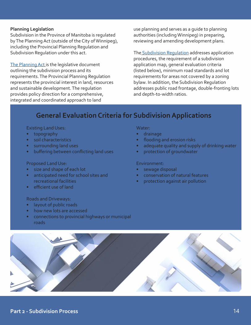
Existing Land Uses:• topography• soil characteristics• surrounding land uses• buffering between conflicting land uses
Proposed Land Use:• size and shape of each lot• anticipated need for school sites and
recreational facilities• efficient use of land
Roads and Driveways:• layout of public roads• how new lots are accessed• connections to provincial highways or municipal
roads
Water:• drainage• flooding and erosion risks• adequate quality and supply of drinking water• protection of groundwater
Environment:• sewage disposal• conservation of natural features• protection against air pollution
Planning LegislationSubdivision in the Province of Manitoba is regulated by The Planning Act (outside of the City of Winnipeg), including the Provincial Planning Regulation and Subdivision Regulation under this act.
The Planning Act is the legislative document outlining the subdivision process and its requirements. The Provincial Planning Regulation represents the provincial interest in land, resources and sustainable development. The regulation provides policy direction for a comprehensive, integrated and coordinated approach to land
use planning and serves as a guide to planning authorities (including Winnipeg) in preparing, reviewing and amending development plans.
The Subdivision Regulation addresses application procedures, the requirement of a subdivision application map, general evaluation criteria (listed below), minimum road standards and lot requirements for areas not covered by a zoning bylaw. In addition, the Subdivision Regulation addresses public road frontage, double-fronting lots and depth-to-width ratios.
14
General Evaluation Criteria for Subdivision Applications
Part 2 - Subdivision Process

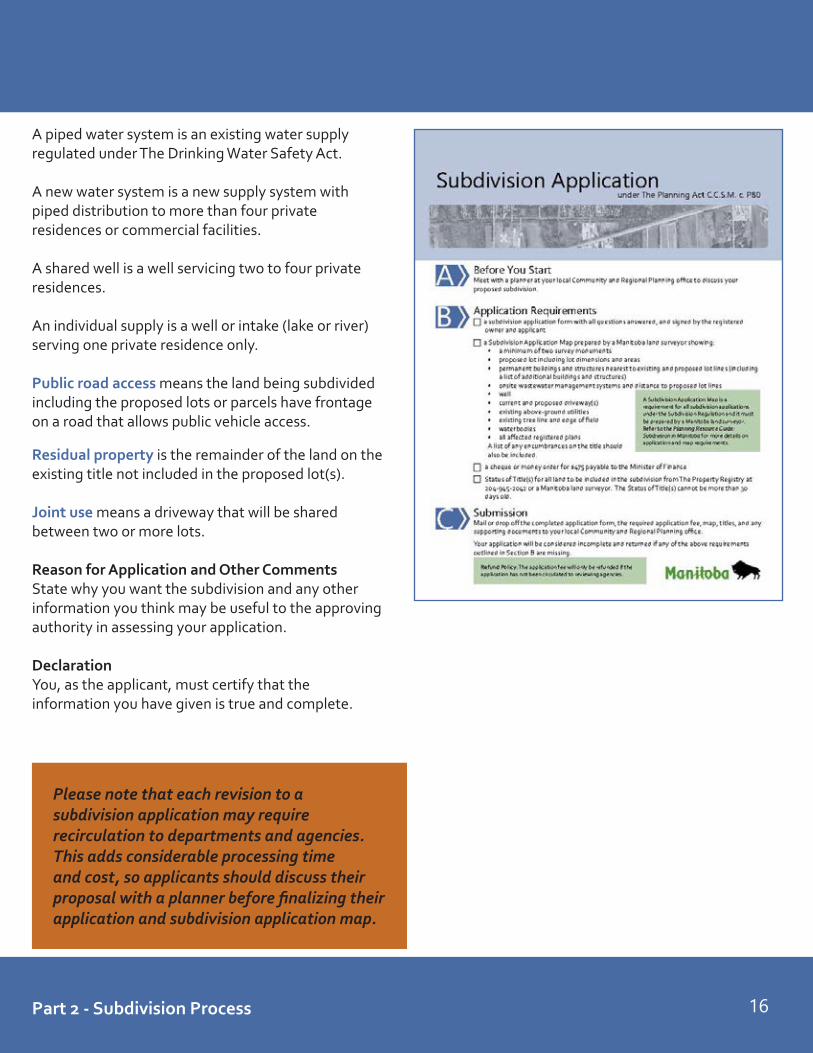
You can get a copy of the Subdivision Application from your local Community and Regional Planning office or on the department’s website: www.gov.mb.ca/ia/land_use_dev/sra.html.
RequirementsYour application must include:
• The application fee ($475) payable to theMinister of Finance. (Note: Where approvingauthority has been delegated to a planningdistrict, it will set its own fee schedule and collectthe fees.)
• A current copy (dated within 30 days) of eachstatus of title or deed covering the land to besubdivided from the Land Titles Office or aManitoba land surveyor.
• A subdivision application map prepared by aManitoba land surveyor showing the existing andproposed features of the land being subdivided.
Make sure that all questions are answered and that all registered owners sign the application.
Mail or take your completed application to the appropriate office for subdivision applications. See page 68 for locations.
Application FormApplicantThis is the person making the application and to whom all correspondence will be sent. Only the owner (or a person authorized in writing by the owner) can apply for subdivision approval. If you want correspondence about your application by email, please include your email address.
Registered OwnersThis is the name of the owner(s) registered with the Land Titles Office. The name(s) is shown on the status of title or certificate of title.
If the person who owns the land is not the applicant, the registered owner(s) must sign the application authorizing the person to apply for them.
LocationThe location of the land being subdivided is shown on the title. The land being subdivided may be described by lot or parcel, block and plan numbers or section, township and range.
Land UseCheck all the boxes that apply and describe them in the space provided. If you check Other explain in the space provided.
Flooding and DrainageCheck the appropriate boxes to identify if your land has been flooded and how the proposed lot will be drained.
Servicing and AccessCheck the appropriate boxes to identify all existing and proposed sewage disposal systems and water supply systems for both the proposed lot(s) and residual land. Note: New ejector systems will not be permitted.
Provide the system name, if applicable, for the water supply.
15
For complex proposals or applications for multiple lots the approving authority may require additional information, including, but not necessarily limited to:• geotechnical and related engineering
reports• elevations and contour lines• high water marks, shorelines, and
elevations of water
Meet with the planner to determine if any extra information is necessary.
Part 2 - Subdivision Process
Please note that each revision to a subdivision application may require recirculation to departments and agencies. This adds considerable processing time and cost, so applicants should discuss their proposal with a planner before finalizing their application and subdivision application map.
A piped water system is an existing water supply regulated under The Drinking Water Safety Act.
A new water system is a new supply system with piped distribution to more than four private residences or commercial facilities.
A shared well is a well servicing two to four private residences.
An individual supply is a well or intake (lake or river) serving one private residence only.
Public road access means the land being subdivided including the proposed lots or parcels have frontage on a road that allows public vehicle access.
Residual property is the remainder of the land on the existing title not included in the proposed lot(s).
Joint use means a driveway that will be shared between two or more lots.
Reason for Application and Other CommentsState why you want the subdivision and any other information you think may be useful to the approving authority in assessing your application.
DeclarationYou, as the applicant, must certify that the information you have given is true and complete.
16Part 2 - Subdivision Process

Additional Information• A subdivision application will only be accepted
with a SAM.• There are generally no exceptions to the SAM
requirement.• The approving authority will use the SAM for
conditional approval.• The SAM (in a version modified by your Manitoba
land surveyor), may be used in lieu of a legal description for registration at the Land Titles Office, under Section 128(3) of The Real Property Act.
• The SAM may take the form of the draftPlan of Subdivision prepared by a Manitoba land surveyor which will be deposited at land titles for examination following conditional approval, with applicable SAM features included (ex. two found survey monuments, structures that will remain on site, existing utilities, driveways, etc.).
Subdivision Application Map (SAM)
You can find a list of Manitoba land surveyors at www.amls.ca.
17 Part 2 - Subdivision Process
Map should include the following:1. survey monuments (minimum of two on same limit)2. proposed lot(s) with dimensions and area3. structures:
• including the main use and each building/structurenearest to the existing and proposed lot lines
• a list of additional buildings and structures4. driveway(s), including:
• location of current access, access to proposedlot and any other proposed accesses
• distance from centre line of current access tonext access if on a Provincial Trunk Highwayor Provincial Road
5. onsite wastewater management systems anddistance to proposed lot lines
6. well7. existing above-ground utilities8. existing tree line and edge of field9. major water bodies (ex: lake, river, stream)10. all affected registered plans and easements11. a list of any encumbrances/caveats on the title12. any other relevant information
Status of TitleAll subdivision applications must be accompanied by a Status of Title. You can obtain a status of title in one of two ways:
1. your surveyor will provide a copy of the title with the SAM; or
2. contacting your local Land Titles Office.
In order to find the title for a particular piece of land, the Land Titles staff must be provided with the current title number, or the legal description. The legal description of the land is not the same thing as the civic address.
A status of title costs $23. Additional information on title searches and other FAQs can be found on The Property Registry website: www.tprmb.ca.
Land titles has two formats of titles: paper titles and electronic titles. All titles created after 1988 in the Winnipeg Land Titles Office are electronic titles, although paper titles were still being created in the rural land titles offices until the late 1990s.
All paper titles are now in the process of being converted to electronic titles. If an applicant has a paper title (or duplicate), it can be converted to electronic title. CRP can send a paper title to LTO and request conversion. When LTO receives an application with a paper title, LTO will convert it to electronic title. There is no charge to convert paper titles to electronic.
A SAM is a map prepared by a Manitoba land surveyor showing the key features of the land involved in the subdivision. All subdivision applications must be accompanied by a SAM.

18Part 2 - Subdivision Process
Rural Example
Urban Example

Review and Circulation
Receipt and Review of ApplicationThe CRP planner will review your application and map to ensure it is complete. When accepted as complete, you will receive a letter of acknowledgment and processing of your application will begin. If your application is incomplete, you will be asked to provide the missing information.
CRP will prepare a site map with ortho imagery and a location map to be circulated along with your application. The planner will use the surveyor's subdivision appliction map to ensure accuracy.
The planner reviews the proposal to ensure it meets the provisions of the applicable development plan and zoning bylaws and the Subdivision Regulation.
Circulation of ApplicationFollowing review, your application is circulated to various government departments and agencies for their review. The departments and agencies have 20 days to respond.
Comments received from government departments and agencies are sent with a planning report to the municipal council, with a copy to you.
Report to CouncilThe planning report includes an explanation of the proposal, relevant background and contextual information, development plan policies, zoning bylaw regulations, government department and agency comments, and recommendations to council. It is intended to give council the information they need to make an informed decision on your proposal.
Municipal council will add your subdivision application to their meeting agenda. If you want to appear before council to explain your proposal, you should contact the municipality directly.
Municipal Council Decision If the proposed subdivision will result in the creation of a new public road, the council must hold a public hearing to receive representations on the proposed subdivision and give notice of the hearing in accordance with section 169 of The Planning Act before approving the application by resolution.
Some municipalities hold a public hearing for all subdivision applications, regardless of whether a public road is proposed or not. Contact your municipal office to find out if this is the case in your jurisdiction.
The municipal council considers your application, together with the planning report, and decides either to approve it (with or without conditions) or to reject it.
Council’s conditions may relate to such items as development agreements, drainage, driveways, additional fees, etc. These conditions will be included in their approving resolution.
Council sends a copy of the decision to the appropriate approving authority. The approving authority can proceed only after council’s decision has been received.
If council rejects a subdivision, the approving authority must also reject the subdivision. If this is the case, you will receive a letter advising that your application has been rejected. A decision of council to reject an application cannot be appealed, and you must wait six months to make a new application.
19
2/3STEPS
Part 2 - Subdivision Process

Decision
Approving Authority DecisionIf council has approved your application, the approving authority must determine if the proposed subdivision: • conforms with local bylaws such as development
plans and zoning bylaws and provincial policies• is suitable for the proposed use• may be expected to be used within a reasonable
period of time
If the approving authority determines your application meets all requirements under The Planning Act, it will issue you a letter of conditional approval. This letter sets out the conditions and requirements that must be met before the subdivision can be registered in Land Titles.
AppealsIf the approving authority rejects your subdivision, you may appeal the decision within 30 days of the date of the approving authority’s notice of decision. There is, however, no appeal if the council rejected your application.
If the approving authority fails to make a decision within 60 days of the council resolution approving the subdivision, you may consider the application as having been rejected by the approving authority and appeal.
You may also appeal any of the conditions of your approval, including any of the conditions required by council. Please note that Requirements including Land Titles survey requirements and lot approval fees cannot be appealed.
Appeals must be made in writing to The Municipal Board of Manitoba.
20
4STEP
Part 2 - Subdivision Process

Conditional Approval
As per The Planning Act (s. 135), a subdivision of land may be approved subject to one or more of the following conditions, which must be relevant to the subdivision:
• any condition necessary to ensure compliance with The Planning Act or another act, regulation, or a development plan bylaw, secondary plan bylaw or zoning bylaw
• any condition necessary to satisfy the requirements of a municipal bylaw, including the payment of fees and levies, and the requirement to pay property taxes
• a condition that the applicant enter into a development agreement with the government, the municipality or the planning district, as required
• any condition recommended or required by a government department or other entity to which the application was referred by the approving authority
• any condition necessary for the proper design of the subdivision or to implement the reorganization of titles
• a condition that the applicant dedicate the following land, without compensation:
• land for adequate public roads and municipal services in the subdivision
• land for public reserve purposes, not exceeding 10 per cent of the land being subdivided, but only if the land is being divided into parcels of less than 4 hectares or cash in lieu
• land for school purposes, not exceeding 10 per cent of the land being subdivided or cash in lieu
• land not suitable for building sites or other development because it is unstable, subject to severe flooding, required for source water protection, or is otherwise unsuitable
• shore lands designated in a development plan bylaw as land to be dedicated upon subdivision as a Crown reserve or a public reserve, including access to shore lands
An approval fee of $200 is payable for each new lot created by the subdivision.
Note: Where approving authority has been delegated to a planning district, it will set its own fee schedule and collect the fees.
A conditional approval is valid for two years to permit you time to meet the conditions. This period may be extended for an additional year, upon written request received by the approving authority prior to the expiry date and accompanied by the extension fee ($200).
21
5/6STEPS
Part 2 - Subdivision Process

You have two years to meet your conditions. The expiry date is provided at the top of the letter.
The letter is addressed to the individual listed as the applicant in the application form. Please advise CRP staff if you want a copy to go to anyone else (ex: lawyer, surveyor).
REQUIREMENTS:(A) The CRP approval fee is $200 for each new lot created. Where no new lots are created (i.e. consolidation), the fee is $200.(B) This is Land Titles’ requirement for either a legal description, plan of subdivision or a plan of survey. Land Titles will also provide additional surveying instructions if required, as well as notice respecting mortgage amendments and discharge, duplicatecertificateoftitlesandsignaturesrequiredontheMylarsTM prior to registration.
CONDITIONS:Nos. 1 and 2 are typically the municipality’s conditions. These willincludesuchthingsasconfirmationthattaxesarepaid,lot levies or dedication fees, development agreements, zoning amendments, variances or conditional use orders, and Building LocationCertificate(s).
The remaining conditions include departmental and agency conditions, such as utility easements, highways permits, and confirmationofonsitewastewatermanagementsystemcompliance.Youcanfindmoreinformationregardingpotentialdepartment conditions in Part 3 of this guide.
Statutory requirements are also provided under the heading: Please also note the following. These are not conditions, but regulatory requirements and notices that you should be aware of as they may impact the future development of your land.
The conditional approval will also include a copy of council’s resolution and the approved map.
If you have any concerns with the map, contact CRP or the planning district approving authority immediately.
22Part 2 - Subdivision Process

23
Conditions can be completed at the same time. Some conditions (easement agreements, permits and licenses from agencies) may take time to process and complete. Please note the timelines associated with each requirement and plan accordingly.
You’ve received a conditional approval letter...now what?1. Notify your surveyor
Give your surveyor a copy of your conditional approval letter including the approved map. Your surveyor will begin meeting Land Titles plan (or in rare circumstances land description)requirements,preparinganyrequiredbuildinglocationcertificate(s),andworking with utilities to prepare any required easement plans or facility sketches.
2. Call your municipal office to discuss your municipal conditions (Condition #2 in the conditional approval letter). Municipal staff can assist you in meeting these requirements and provide the necessary forms and fees to proceed.
3. Find an engineer if you require engineered plans or studiesIf you need a drainage plan, lot grade plan or geotechnical engineer’s report, you will needtohireanengineer.Youcanfindanengineeratapegm.mb.ca/directory or in the Yellow Pages.
4. Enter Easement AgreementsManitoba Hydro will send you an instruction letter if they require easements. You will need a lawyer to complete your Manitoba Hydro easement. If you only require an MTS easement, contact MTS directly at the number provided in the conditional approval letter.
5. Apply for Highways PermitsApplyforanyrequiredHighwayTrafficBoardorManitobaInfrastructurepermitsimmediately to avoid potential seasonal delays in processing.
6. Complete all other government and agency conditionsContact information is included with each condition. CRP can also supply required forms upon request.
Details about possible conditions are provided in the next section. Not all conditions are required for all subdivisions. Review your conditional approval letter to see which conditions apply to your proposal.

Subdivision Requirements and Conditions
24
PART 3

In Manitoba, Teranet owns and operates The Property Registry (Land Titles Office or LTO). LTO reviews all subdivision applications and determines if the proposed subdivision requires a Plan of Subdivision, Plan of Survey or a land description.
Once LTO receives a copy of the conditional approval letter from CRP, it is reviewed and the information is entered into the survey books.
PreapprovalLTO waits until it receives prints of the Plan of Subdivision or survey from the surveyor then examines the plan for errors and reviews survey evidence. LTO notifies the surveyors of any corrections to be made, then waits for the surveyor to send the revised plan back. LTO reviews the revisions and then notifies the surveyor that they may create the MylarsTM. The MylarsTM are then forwarded to the approving authority by the applicant or by the surveyor on request. This pre-approval process generally takes six to eight weeks.
Land descriptions prepared by a lawyer or surveyor must also be submitted to LTO for tentative approval. These are generally reviewed and approved within one day. Land descriptions must then be submitted to the approving authority.
Once the applicant has completed all of the conditions, the MylarsTM are signed by the approving authority and a certificate of approval is issued.
ConsolidationsA consolidation occurs when more than one lot is joined together legally to create a new single lot. Consolidations do not require planning approval. Sometimes consolidations are required as part of a subdivision proposal, but that is the only time that CRP needs to be involved in consolidations.
Please note that consolidations can cause significant problems. Existing mortgages that only affect some of the lands being consolidated will likely have to be discharged and then new mortgages will have to be registered. Certain caveats may have to be discharged. Further, to later separate two pieces of land that have been consolidated may require planning approval, which can be an expensive process. It is strongly recommended that anyone considering consolidating two pieces of land obtain legal advice on the possible costs and long term ramifications before proceeding.
The applicant (or applicant’s lawyer) collects the necessary signatures on the MylarsTM, prepares documents for registration, and forwards the MylarsTM and documents to LTO for registration. The plan is registered, new titles are issued and certified copies are sent to the applicant (or applicant’s lawyer). This process takes approximately one to two weeks.
Plan examination fee: $130 (not charged for land descriptions)
Plan of SubdivisionPlans of subdivision are required for many reasons. These include: • Plans provide a clear and concise picture of the
land being subdivided, eliminating the confusion and uncertainty created by multiple splits by land description.
• When plans are prepared permanent survey monuments are placed in the lands being subdivided. These monuments can be used later for locating property boundaries.
• Having a plan prepared is one way to ensure that the land intended to be subdivided is the land that is actually subdivided.
• Having a plan prepared ensures that tree lines, fences, buildings, roads and the like are on the property they are intended to be on.
• All new plans add to the survey fabric of lands in the province, making land holding more certain and safer.
Land Titles Surveys and Land Descriptions
25 Part 3 - Subdivision Requirements and Conditions

Plan of Survey (Explanatory Plan)In accordance with The Planning Act, explanatory plans are only to be used for all or the balance of the land contained in a Certificate of Title. Exceptions will be allowed in the following situations for subdivisions, providing there is no requirement to create a public interest such as a public road:a. to resolve differences in mines and mineral
ownership in plans of subdivisionb. to accommodate planning consolidation
requirements and contiguity issuesc. to accommodate an easement agreement or
rights-of-way for ingress and egressPublic roads or reserves may not be created on an explanatory plan.
Plan of Bare Land CondominiumThe difference between a bare land condominium plan and other condominium plans is a bare land plan will show parcels of land as the units on the condominium plan. Such bare land units may have existing buildings on them, but they would not be completely covered by these buildings. A condominium proposal which shows only buildings or parts of buildings as the condominium units does not require the approval of the approving authority. However, a condominium proposal may also require a subdivision approval if all or part of the land is to be shown as lots or blocks on a plan of subdivision.
A bare land condominium plan requires the approval of the subdivision approving authority and the Registrar-General. Land DescriptionsIn general, the only subdivisions which do not require plans are those that are bounded by a natural feature or split by a highway or railroad. In some cases a land description will be allowed when the limits of the land to be transferred can be described using existing neighbouring plans.
Any subdivision of a river lot, outer two mile lot, settlement lot, wood lot, or township lot that creates a new title boundary will require a plan of survey or subdivision.
Any land already subdivided by a plan will require a plan to subdivide it.
Do I need a lawyer or a surveyor to subdivide my property? A Manitoba land surveyor is required to create the subdivision application map (SAM). The surveyor will ensure that the lands being subdivided are the lands the parties intend to subdivide. A lawyer is recommended and will ensure the proper completion and registration of required documentation.
While technically you are not required to hire a lawyer to register documents at Land Titles, some Land Titles documents (including the transfer of land) cannot be completed without the involvement of a lawyer. Signatures in certain Land Titles documents must be witnessed by a lawyer as well. Given that registration of documents causes land titles records to be changed and this can significantly change your legal position and rights, a lawyer can help make sure that you are properly advised and protected.
Please note that staff at the Land Titles Office are prohibited from assisting or advising you regarding forms that can cause a change to your legal rights and interests in land, including transfers of land.
Surveys and Land Descriptions
26Part 3 - Subdivision Requirements and Conditions

Utilities MTS and Manitoba Hydro
27
In accordance with The Real Property Act, utility easements (rights-of-way) require registration in the Land Titles Office. The developer is required to grant Manitoba Hydro and the communication utilities easements for the purpose of placing and maintaining services throughout the subdivision, for both existing and future facilities. The easement may be used for common trench locations, pad-mounted transformers, communication hand-holes, pedestals and other related features.
Approximately 40 per cent of all subdivision applications require an easement agreement to be completed with Manitoba Hydro. A plan of easement is also required for registration of these easements at Land Titles, prepared by a professional surveyor.
General Considerations for Easements:• Manitoba Hydro requires the name of the applicant’s lawyer. A lawyer is required to execute the easement
agreement and register the plan. • All multiple-family dwellings (including semi-detached and duplexes) and condominiums automatically require
blanket easements. Blanket easements are completed as a legal description. • Utilities must be advised of whether a proposal is for a multi-family dwelling or condominium and of any future
phases of development. Future phases (including plans for sidewalk placement, road widening, etc.) may impact the location of utility infrastructure. This will not increase costs to the developer or bind the developer to that idea, but it is required for information purposes.
Hydro Easement Requirement: Timeline for processing: six months or longerAn easement agreement fully executed by the developer that will be registered at the Land Titles Office prior to any transfers of land. In order to prepare the documentation Manitoba Hydro requires the following:
• conditional approval from the approving authority• final plan of subdivision/survey or pre-approved land description• developer’s lawyer’s contact information (a lawyer is required for execution of the agreement)• easement plan if applicable
Developers will be provided with contact information once CRP issues the conditional approval letter. The developer’s surveyor (or lawyer for legal descriptions), will then complete the plan of subdivision (or land description) and forward it to Manitoba Hydro. After reviewing the plan, Hydro will provide the surveyor with the easement requirements. The surveyor then prepares the plan of easement and submits it to Manitoba Hydro for its review. The plan of easement and supporting Manitoba Hydro documents are forwarded to the LTO in Winnipeg for pre-approval. The easement agreement is prepared and, along with the MylarsTM for the plan of easement, circulated to all involved utilities for their signature. Once Manitoba Hydro has received all the necessary signatures, a final easement agreement package is created which includes a trust letter, release of conditions letter, and the plan of easement MylarsTM and is forwarded to the applicant’s lawyer. The applicant’s lawyer obtains the applicant’s signature and submits the plan of easement to LTO for registration. Registration in series with the subdivision is typically included as a condition on the Certificate of Approval.
When complete, your lawyer must send the release of conditions letter to Community and Regional Planning (or approving authority) for the condition to be considered satisfied.
Part 3 - Subdivision Requirements and Conditions

MTS and Manitoba Hydro
28
These requirements ensure that MTS Inc. communication facilities (or other company facilities in some parts of the province) can be installed and maintained for all subdivided parcels of land. This would include any existing and future facilities that must be protected by easement rights. MTS reviews all subdivision applications to determine if easement agreements are necessary for their infrastructure. Approximately 25 per cent of all subdivision applications will require a joint Hydro/MTS easement agreement to be completed and another 20 per cent require an easement agreement only with MTS. If the easement is to be prepared jointly with Manitoba Hydro, then the internal process of Hydro is followed. Otherwise, MTS has established its own internal easement agreement process.
Removal or relocation of Manitoba Hydro or MTS equipment as a result of the proposed subdivision will be at the expense of the developer.
MTS Easement Requirement: Timeline for processing: three months or longer (MTS solo easement agreement)An easement agreement fully executed by the developer that will be registered at the Land Titles Office prior to any transfers of land. In order to prepare the documentation MTS Inc. requires the following:
• conditional approval from the approving authority• final plan of subdivision/survey or pre-approved land description• developer’s lawyer’s contact information• easement plan if applicable
MTS reviews the application and highlights where the easement is required and forwards these requirements to the applicant’s surveyor. The surveyor creates the plan of easement and returns it to MTS for review. MTS reviews and then prepares the easement agreement. The easement agreement is sent to the applicant for their signature, and then the agreement is returned to MTS. MTS prepares a final easement agreement package and provides it to the developer’s lawyer or directly to LTO for registration.
MTS (solo) will also sometimes ask for a metes and bounds (land) description and has it signed and registered prior to registration of the subdivision. In this case a release is sent to CRP indicating that registration of the easement is not required as a condition on the certificate.
For more information:Prospective developers seeking information on existing MTS facilities in their planned development area or with any questions related to the development should forward their questions to:
MTS Inc. - Network Engineering Control CentrePhone: 204-941-4369 – Winnipeg Toll Free Phone: 1-866-756-7642Fax: 204-957-5619E-Mail: [email protected]
Easement requirements for Manitoba Hydro electric, telephone and cable TV will be included on a single agreement administered by Manitoba Hydro. A separate easement agreement is required for Manitoba Hydro’s natural gas installation.
Part 3 - Subdivision Requirements and Conditions

Municipal ConditionsMunicipal council may approve your subdivision application with conditions in their resolution. Council’s conditions must be included in the conditional approval letter. The following municipal conditions are typical:
Payment of Taxes:Any outstanding property taxes on the subdivision lands must be paid in full or arrangements satisfactory to the municipality made.
Survey Monuments:If survey monuments are missing and are required for a Plan of Subdivision, the owner is responsible for paying the municipality the amount in excess of funds approved by the Land Titles Office.
Variances:A variance order is required if a proposed lot does not meet the minimum site area and width requirements for your zone, or if buildings and structures do not meet the minimum setbacks. To determine if buildings and structures meet the minimum setbacks, you may be required to provide a Building Location Certificate prepared by a Manitoba land surveyor. A public hearing is required for a variance.
Conditional Uses:A conditional use order is required if the proposed use of your land or buildings is one listed as a conditional use in the bulk table for your zone in the zoning bylaw. A public hearing is required and council may impose conditions on your proposed use in their order.
Zoning Bylaw Amendments:Every municipality has its own zoning bylaw, which affects the way that property can be used. If the proposed use does not comply with the zoning bylaw, a zoning bylaw amendment will be required.
Land and School Dedication:Council may require the developer to dedicate land for public reserves or school purposes. The amount of land dedicated cannot exceed 10 per cent of the total land being subdivided. Council may also require the land owner to provide money in lieu of land.
Opening and Closing Roads:The municipality must hold a public hearing if the proposed subdivision will result in the creation of a new public road (s. 125(2) of The Planning Act).
In some instances, a road closing bylaw may also be required, if the proposed subdivision involves portions of an unused road allowance that will form part of the proposed lots.
Lot Levies and Dedication Fees:In most municipalities, the developer is responsible for providing the services and infrastructure within a proposed subdivision. Developers are also required to contribute to lot levies, dedication fees and other charges. For example, lot levies may be collected to defer some of the costs for trunk services outside of the subdivision area. Reserve fund contributions may also be required for future water and sewer upgrades. Dedication fees can be collected in lieu of land or school dedication. Legal and engineering fees may also be paid by the developer. Each municipality charges different fees, and charges may differ in different areas of the municipality. Consult your local municipal office for more information.
Declaration of Right-of-Way: If the dominant and servient lands are owned by the same parties, a Declaration of Right-of-Way is required (used when establishing a right-of-way on your own land). These can only be discharged with the consent of all owners and all encumbrancers on the affected lands.
Right-of-Way Agreement:If the dominant and servient lands are owned by different owners, a Right-of-Way Agreement registered by way of caveat is required. A caveat protecting an easement can be discharged by the current owner of the dominant lands.
Lot Grading or Drainage PlanThe developer may be required to submit a lot grade and/or drainage plan, prepared by a professional engineer, showing elevations and the overall drainage patterns on the subject lands.
29 Part 3 - Subdivision Requirements and Conditions

Easements, Covenants and CaveatsCaveats:The Real Property Act allows a person who is claiming an interest in land to register a caveat. For the purposes of The Real Property Act, person includes natural persons and corporations. Land Titles will not accept as caveator a trust, a family trust, a limited liability partnership, a partnership or a law firm.
For the benefit of future parties, it is wise to attach copies of relevant agreements to caveats. Where the caveat is filed pursuant to section 111 of The Real Property Act (Rights analogous to easement and statutory easements), or is a development agreement filed by a municipal government (other than the City of Winnipeg), the agreement must be attached.
Restrictive Covenants:Traditional Restrictive Covenants:The first type of restrictive covenant caveat gives notice of an agreement entered into between a vendor and a purchaser of land, wherein certain restrictions are imposed upon the uses the purchaser can make of the subject lands, which restrictions are for the benefit of other lands owned by the vendor.
To be registerable at Land Titles a caveat based upon a traditional restrictive covenant must specify both the beneficial (dominant) and the affected (servient) lands.
Building Schemes/Development Schemes:The second sort of restrictive covenant that can be protected by caveat is one imposed by a developer. These are caveats registered by a party who has subdivided a large piece of land into numerous lots and is selling off the lots. These caveats are based upon separate agreements between the developer and the purchasers of each separate lot.
Development Agreement:Pursuant to The Planning Act, municipal governments outside the City of Winnipeg have the authority to enter into development agreements in the following circumstances:• as a condition of amending a zoning bylaw• as a condition of making a variance order• as a condition of approving a conditional use• as a condition of approving a conditional use for a
livestock operation• as a condition of subdivision approval
Note: Section 151(1) of The Planning Act specifies that development agreements must contain a specific statement that the agreement runs with the land it affects. The act also requires that a copy of the actual agreement be attached to the caveat registered.
The agreement must be between the municipal government and those parties who are the registered owners of the affected lands at the time the agreement is registered at Land Titles.
As per The Planning Act, the development agreement can deal with:• the construction or maintenance – at the owner’s
expense or partly at the owner’s expense – of works including sewer and water, waste removal, drainage, public roads, connecting streets, street lighting, sidewalks, traffic control, access, connections to existing services, fencing and landscaping
• construction or payment by the owner of all or part of the capacity of works in excess of the capacity required for the proposed subdivision
• the use of the land and any existing or proposed building
30Part 3 - Subdivision Requirements and Conditions

Provincial Highways
Subdivision applicants may be required to obtain an access or change in use permit from Manitoba Infrastructure (MI) or the Highway Traffic Board as part of the subdivision process if the proposed subdivision is adjacent to a provincial road (PR) or provincial trunk highway (PTH).
Subdivision Planning at the Local LevelHighway Access Permit RequirementsUnder The Highway and Transportation Act (Section 8-3), the Minister of Manitoba Infrastructure (via the Access Management section of MI’s Highway Planning and Design Branch) is the approving authority for any access to and structures, signs and plantings onto and adjacent to non-limited access highways. Non-limited access highways include all of the provincial roads (PR) numbered 200-599 and the PR access roads.
Under The Highway Protection Act (Section 5), the Highway Traffic Board is the approving authority for access (including change in use), structures and signs onto and adjacent to all limited access highways. Limited access highways include all of the provincial trunk highways (PTH) which are numbered from 1 to 199 as well as PR 230.
Highway ClassificationsAll Manitoba highways currently fall under the following classifications:
• expressways• arterials (primary and secondary)• collectors
Access Spacing Supported by Manitoba Infrastructure:Expressways – No direct property access. These routes are limited access highways that carry very large traffic volumes with a high percentage of trucks over long distances. All connections will have proper intersection treatments.
Primary Arterials – These routes are limited access highways that carry large traffic volumes and a relatively high percentage of trucks.
Secondary Arterials – These routes are generally limited access highways that carry moderate volumes of passenger vehicles and a lower percentage of trucks.
Collectors –These highways are generally non-limited access roads that carry low to moderate volumes of traffic. Some collectors in populated areas could carry large volumes of traffic in excess of 4,000 vehicles per day.
31 Part 3 - Subdivision Requirements and Conditions

32
Part 3 - Subdivision Requirements and Conditions
Manitoba Infrastructure General Considerations when Subdividing Adjacent to a Highway:
• Strip development, or development that contributes to the evolution of a row of lots, that fronts on and requires direct connection to a provincial highway will not be permitted.
• Overall planning of a site should be undertaken to ensure that highway access meets the desirable spacing for the highway that is being considered for access connection.
• Access to a provincial highway is not guaranteed. Where possible, government would prefer that all access be from a municipal road already connected to the provincial highway network, and approval may not be given to direct access onto the highway.
• Should access onto a provincial road be the only alternative, Manitoba Infrastructure may decide to maximize the spacing between new and existing accesses, place any new accesses at a joint property line or relocate existing accesses to provide access to land at a better location.
• With any proposed development along a provincial highway, or in conjunction with any possible upgrading of the highway, existing access connections may be relocated or removed and replaced by alternative access.
• Manitoba Infrastructure may request preliminary traffic information, a traffic impact study or on-highway improvements, where the proposed development requires a direct private access or public road connection onto the highway.
• Private accesses are generally not allowed within close proximity to intersections located along the provincial highway network.

Permit - Provincial Roads (PRs)Time to Complete: approximately four to eight weeks (processing times vary seasonally)
Permit Covers: • new access• access relocation or removal• construction within a control zone • signs• tree plantings
Highway Traffic Board Permit - Limited Access HighwaysTime to Complete: Approximately eight to 12 weeks (processing times vary by volume of applications)
Permit Covers: • change in use• access relocation or removal• new access• construction within a control zone • signs
A copy of the subdivision conditional approval letter should accompany all permit applications.
Typical Conditions of ApprovalManitoba Infrastructure
33 Part 3 - Subdivision Requirements and Conditions
Manitoba Infrastructure Permit Process
Average processing time of 4 to 8 weeks
Applicant applies for an access permit at MI. All applications for access on provincial roads are forwarded to the Highway Planning and Design Branch (HPD).
HPD forwards a permit application to appropriate region. An on-site inspection is conducted and a sketch is sent back to HPD.
HDP anaylzes the information and makes a decision.
If approved, the permit is forwarded to the applicant. If denied, the applicant is notified. An applicant may appeal the decision.
Highway Traffic Board Permit Process
Average processing time of 12 to 16 weeks
An applicant applies for a change in use or access permit onto a limited access highway at the Highway Traffic Board.
The HTB sets the hearing date and prepares the agenda for the public hearing (held in Winnipeg or Brandon).
A permit application is forwarded to MI’s Highway Planning and Design Branch, then to the regional office.
An on-site inspection is conducted and a sketch is sent back to HPD. Analysis and draft sketch plans are sent to the HTB.
HTB conducts a hearing. After the hearing, minutes are prepared and forwarded to HPD.
HPD reviews the decision, makes corrections if necessary, prepares the permit, and sends it to the applicant.
Contact: Highway Planning and Design, Manitoba Infrastructure
Permit applications affecting provincial roads (PR) are processed internally by the Highway Planning and Design Branch of MI.
Permit applications affecting limited access highways (PTHs) are processed by the Highway Traffic Board (HTB).
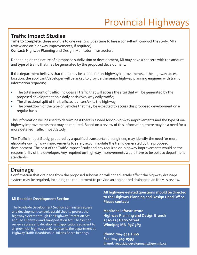
Provincial HighwaysTraffic Impact StudiesTime to Complete: three months to one year (includes time to hire a consultant, conduct the study, MI’s review and on-highway improvements, if required)Contact: Highway Planning and Design, Manitoba Infrastructure
Depending on the nature of a proposed subdivision or development, MI may have a concern with the amount and type of traffic that may be generated by the proposed development.
If the department believes that there may be a need for on-highway improvements at the highway access location, the applicant/developer will be asked to provide the senior highway planning engineer with traffic information regarding:
• The total amount of traffic (includes all traffic that will access the site) that will be generated by the proposed development on a daily basis (two-way daily traffic)
• The directional split of the traffic as it enters/exits the highway• The breakdown of the type of vehicles that may be expected to access this proposed development on a
regular basis
This information will be used to determine if there is a need for on-highway improvements and the type of on-highway improvements that may be required. Based on a review of this information, there may be a need for a more detailed Traffic Impact Study.
The Traffic Impact Study, prepared by a qualified transportation engineer, may identify the need for more elaborate on-highway improvements to safely accommodate the traffic generated by the proposed development. The cost of the Traffic Impact Study and any required on-highway improvements would be the responsibility of the developer. Any required on-highway improvements would have to be built to department standards.
DrainageConfirmation that drainage from the proposed subdivision will not adversely affect the highway drainage system may be required, including the requirement to provide an engineered drainage plan for MI’s review.
All highways-related questions should be directed to the Highway Planning and Design Head Office. Please contact:
Manitoba Infrastructure Highway Planning and Design Branch1420-215 Garry StreetWinnipeg MB R3C 3P3
Phone: 204-945-3660Fax: 204-945-0593Email: [email protected]
MI Roadside Development Section
The Roadside Development Section administers access and development controls established to protect the highway system through The Highway Protection Act and The Highways and Transportation Act. The Section reviews access and development applications adjacent to all provincial highways and, represents the department at Highway Traffic Board/Public Utilities Board hearings.

Water Management, Planning and Standards BranchThe Water Management, Planning and Standards Branch is part of the Hydrologic Forecasting and Water Management Section within the Water Management and Structures Division, Manitoba Infrastructure.
The branch reviews development and subdivision proposals with regard to flooding, erosion and bank stability risks and provides comment and recommendations to Community and Regional Planning, Manitoba Indigenous and Municipal Relations. It also provides data and expertise for flood protection and for design of water control works or other infrastructure sensitive to water levels.
Permanent Structures Near and Adjacent to RiversMajor Rivers and Streams – where the flood hazard has been identified, the flood protection level is the corresponding design flood level plus 0.6 m (2 feet).
In areas where the specific hazard has not been identified, permanent structures should be set back from the top of the embankment at least 10 times the height of the embankment above the Ordinary High Water Mark or 60 m (200 feet) whichever is greater unless an engineering investigation shows that these limits may be reduced.
Minor Rivers and Streams – where the flood hazard has been identified, the flood protection level is the corresponding design flood level plus 0.6 m (2 feet).
In areas where the specific hazard has not been identified, permanent structures should be 1.5 m (5 feet) above ordinary high water elevation with a minimum setback distance of 30.5 m (100 feet) from the top of the waterway embankment to allow for erosion and instability unless an engineering investigation indicates that these limits may be reduced.
Permanent Structures Near and Adjacent to LakesMajor lakes - flood protection for permanent structures near or adjacent to major lakes are determined where sufficient information is available to do so, on a site specific basis by Water Management, Planning and Standards.
In areas where the specific hazard has not been identified, permanent structures should be set back from the top of the shoreline embankment at least 10 times the height of the embankment or 60 m (200 feet) whichever is greater unless an engineering investigation shows that these limits may be reduced.
Minor lakes - where the flood hazard has been identified, the flood protection level is determined where sufficient information is available to do so, on a site specific basis by Water Management, Planning and Standards.
In areas where the specific hazard has not been identified, permanent structures should be 1.5 m (5 feet) above the ordinary high water elevation with a minimum setback distance of 30.5 m (100 feet) from the top of the shoreline embankment to allow for erosion and instability unless an engineering investigation indicates that these limits may be reduced.
For more information, visit the website at www.gov.mb.ca/mit/wms/wm.
Manitoba Infrastructure
35 Part 3 - Subdivision Requirements and Conditions

• The flood hazard is assessed based upon documented, historical information, or upon calculated design flood levels, aerial imagery and available topographic information.
• The minimum design flood criterion used in assessing a particular site for flooding concerns is the 200-year flood level, the flood of record or whichever is greater.
• The flood protection level is defined as the corresponding design flood level (either 200-year flood level or the flood of record) plus freeboard to allow for wind setup, wave effects and unknowns such as ice jams. The flood protection level varies from location to location and may be determined, where sufficient information is available to do so, by Water Management Planning and Standards on a site-specific basis.
• Permanent structures should be set back, from the top of the embankment or shoreline of an adjoining watercourse or waterbody, sufficient distance to allow for erosion and instability, over the ensuing 50 year period.
• Flood-prone lands should generally not be used for permanent structures. They should be left in their natural state or developed for uses compatible with the hazard, such as agriculture or open space recreational uses.
• Where local planning documents provide allowance for the subdivision and development of permanent structures on flood-prone lands, it should be approved only if flood protection is provided for all permanent structures.
Hazard Lands and Riparian Areas
Subdivisions are reviewed by Water Management, Planning and Standards primarily for flooding issues, but also erosion and instability of the embankment or shoreline of an adjoining watercourse or waterbody. The subdivisions are assessed, and recommendations are provided to deter the development of hazard lands or mitigate the hazards, reducing or eliminating damages to property and the personal stresses caused as a result of those damages.
36Part 3 - Subdivision Requirements and Conditions
General Considerations When Developing Adjacent to Waterways:
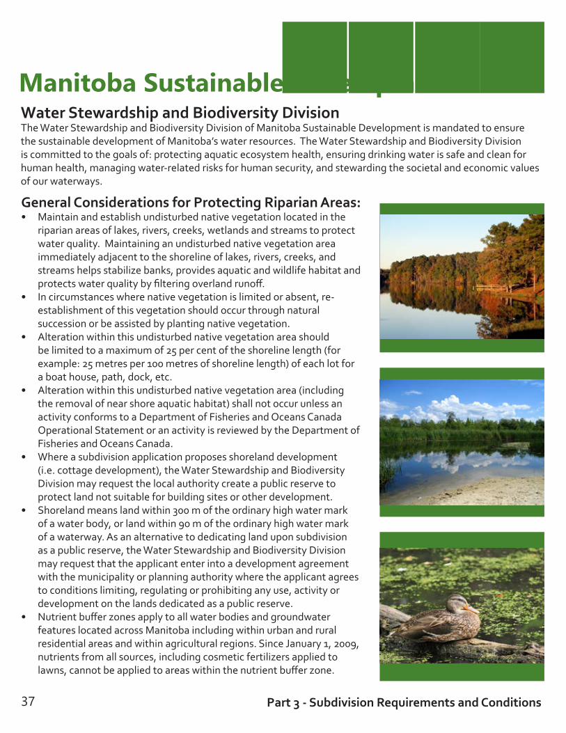
General Considerations for Protecting Riparian Areas:• Maintain and establish undisturbed native vegetation located in the
riparian areas of lakes, rivers, creeks, wetlands and streams to protect water quality. Maintaining an undisturbed native vegetation area immediately adjacent to the shoreline of lakes, rivers, creeks, and streams helps stabilize banks, provides aquatic and wildlife habitat and protects water quality by filtering overland runoff.
• In circumstances where native vegetation is limited or absent, re-establishment of this vegetation should occur through natural succession or be assisted by planting native vegetation.
• Alteration within this undisturbed native vegetation area should be limited to a maximum of 25 per cent of the shoreline length (for example: 25 metres per 100 metres of shoreline length) of each lot for a boat house, path, dock, etc.
• Alteration within this undisturbed native vegetation area (including the removal of near shore aquatic habitat) shall not occur unless an activity conforms to a Department of Fisheries and Oceans Canada Operational Statement or an activity is reviewed by the Department of Fisheries and Oceans Canada.
• Where a subdivision application proposes shoreland development (i.e. cottage development), the Water Stewardship and Biodiversity Division may request the local authority create a public reserve to protect land not suitable for building sites or other development.
• Shoreland means land within 300 m of the ordinary high water mark of a water body, or land within 90 m of the ordinary high water mark of a waterway. As an alternative to dedicating land upon subdivision as a public reserve, the Water Stewardship and Biodiversity Division may request that the applicant enter into a development agreement with the municipality or planning authority where the applicant agrees to conditions limiting, regulating or prohibiting any use, activity or development on the lands dedicated as a public reserve.
• Nutrient buffer zones apply to all water bodies and groundwater features located across Manitoba including within urban and rural residential areas and within agricultural regions. Since January 1, 2009, nutrients from all sources, including cosmetic fertilizers applied to lawns, cannot be applied to areas within the nutrient buffer zone.
37 Part 3 - Subdivision Requirements and Conditions
Manitoba Sustainable DevelopmentWater Stewardship and Biodiversity DivisionThe Water Stewardship and Biodiversity Division of Manitoba Sustainable Development is mandated to ensure the sustainable development of Manitoba’s water resources. The Water Stewardship and Biodiversity Division is committed to the goals of: protecting aquatic ecosystem health, ensuring drinking water is safe and clean for human health, managing water-related risks for human security, and stewarding the societal and economic values of our waterways.

Hazard Lands and Riparian Areas
Geotechnical Engineer’s ReportTime to Complete: Approximately three months to one yearContact: Water Management, Manitoba Infrastructure
• Lands subject to erosion and/or instability should not be used for the development of permanent structures unless the hazard can safely be mitigated as determined by a professional geotechnical engineer. Permanent structures developed on lands above a site which is subject to erosion and/or instability must have a development setback to allow for erosion and/or instability over the ensuing 50 year period.
• For subdivisions fronting directly onto major watercourses or waterbodies beyond the boundaries of the designated flood areas, a geotechnical engineering investigation and report should be prepared to determine the appropriate, site-specific set-back distance for permanent structures, as measured from the top of the embankment of the adjoining watercourse or waterbody.so
Designated Flood Area PermitsThere are two designated flood areas within Manitoba: the Red River Designated Flood Area and the Lower Red River Designated Flood Area, within which the development of permanent structures is governed by The Water Resources Administration Act and Manitoba Regulation 59/2002. For the development of permanent structures within either the Red River Valley Designated Flood Area or the Lower Red River Designated Flood Area, permits must be obtained from Water Management, Planning and Standards (Manitoba Infrastructure) in accordance with Manitoba Regulation 59/2002. Designated Flood Area Permits will not be issued for sites immediately adjacent to waterways within the designated flood areas unless a geotechnical engineering investigation indicates that a flood protected structure may safely be constructed upon that site without negatively impacting bank stability or being subject to erosion.
Riparian Area ProtectionRemoval of vegetation to accommodate construction of permanent structures may lead to, or increase the rate of existing erosion or bank instability. As such, existing tree and vegetation cover should be preserved to reduce erosion and maintain bank stability. Establishment and maintenance of riparian areas along waterways may be included in municipal development agreements, including restrictions on building within these areas.
For more information, please view Planning for the Protection of Riparian Areas at www.gov.mb.ca/ia/plups/pdf/riparian_area_guide.pdf
Typical Conditions of Approval
38Part 3 - Subdivision Requirements and Conditions

39 Part 3 - Subdivision Requirements and Conditions
Mineral ResourcesGeneral Considerations When Proposing Development in Proximity to Aggregate Resources:
Manitoba has a system of dual land tenure where surface rights and mine and minerals rights can be separate and owned by different parties. A parcel of land or title may therefore be owned, leased, managed and used by different parties, creating possible access, use and occupation conflicts. A valid mineral disposition grants the holder the legal right to access the surface of the land for exploration, extraction and development purposes. It is the provincial interest to honour mineral access and development rights associated with mineral dispositions and ensure that appropriate security of tenure is achieved.
Mineral exploration, extraction and development is an industrial land use and can create serious land use conflicts when located in close proximity to residential, recreational, institutional and urban land uses. Mineral resources are hidden, expensive and difficult to identify. Land access is required for mineral exploration and extraction.
The local development plan will identify aggregate resource areas within the municipality or planning district and describe if the resource is a high, medium or low quality deposit. Subdivision of land for residential and other purposes on identified aggregate resources may be prohibited. In some instances, a geotechnical engineering investigation and report on the characteristics of the foundation gravel may be required to determine if development proposals may proceed. A community planner can help you to determine if your land is located in an area identified as having aggregate resources.
Land use planning requirements should recognize the unique characteristics of the industrial activity including subsurface exploration and subsurface mining under-rights. Specific zones that are compatible for mineral resource exploration and extraction are developed and subdivision proponents are advised to seek background information concerning mineral potential and designation, subsurface ownership, and development standards and setbacks required under The Mines and Minerals Act and The Oil and Gas Act. Special consideration to reduce greenhouse gas has also been incorporated into legally protecting viable sources of aggregate and other mineral resources.
For more information, visit the Manitoba Mineral Resources website at www.gov.mb.ca/iem.
Manitoba Mineral ResourcesPhone: 204-945-6569Toll Free: 1-800-223-5215Email: [email protected]

Water and Waste ManagementEnvironmental Compliance and SubdivisionsSubdivision development should be planned to ensure that potential environmental impacts are taken into consideration and orderly growth occurs with respect to onsite and municipal sewer services, solid waste facilities, livestock facilities, chemical storage facilities, and industrial development.
The type of onsite wastewater management system that is most suited to your needs depends on the onsite conditions of your property, the proposed location and wastewater flows. A thorough evaluation of your onsite conditions is crucial in selecting a system that is efficient and cost-effective. All proposed onsite systems must be registered and approved prior to construction, and installed in compliance with the Onsite Wastewater Management System Regulation and the Nutrient Management Regulation.
More information can be found at: www.gov.mb.ca/conservation/envprograms/wastewater/index.html
40Part 3 - Subdivision Requirements and Conditions
General Considerations when Servicing Your Property:
• Locate and install onsite wastewater management systems to prevent degradation of surface and ground water and to protect the environment and public health.
• Municipal sewer collection systems should be used to service areas where high density subdivision is proposed and the collection system must have the capacity available to handle wastewater from the new development.
• Residential subdivisions should be located with appropriate setbacks from wastewater treatment lagoons,
waste disposal grounds, livestock operations and industrial development.
• Urban development should be located a safe distance away from chemical storage facilities.
• Ensure solid and liquid waste disposal is appropriately managed to protect and preserve the environment in provincial parks and Crown land cottage subdivisions and sensitive areas.
• Ensure drinking water is clean and safe for human health. Clean and safe drinking water is critical for maintaining sustainable development for current and future generations in Manitoba.
• Ensure an adequate water supply from surface water sources or groundwater is available that will not affect pre-existing water users. Proposed development may need a water supply for domestic or industrial purposes.

Typical Conditions of ApprovalWater and Waste Management
Confirm Onsite Wastewater Management System Compliance As per Manitoba regulation 83/2003, minimum setbacks must be maintained and in some cases, a minimum site area and width is required to accommodate onsite wastewater management systems. The table on page 42 outlines the requirements for three of the most common components: a septic tank, disposal field and sewage ejector.
In the Red River Corridor Designated Area the method of onsite disposal for new subdivisions is limited to holding tank only.
Connection to a new municipal wastewater collection system or an existing wastewater collection system in the area of the proposed subdivision is required.
For new development in provincial parks, Crown land cottage subdivisions and in sensitive areas, the method of onsite disposal is restricted to holding tank only or municipal collection if available.
Decommission Sewage Ejector or Obtain a Certificate of ExemptionThe owner of the land on which a sewage ejector system is located must take the sewage ejector out of service and replace it with a system which complies with the Onsite Wastewater Management System Regulation prior to the subdivision.
You may be able to keep an existing sewage ejector system, provided that the proposed parcel is a minimum of 10 acres in size, all required setbacks are met, and a Certificate of Exemption is obtained. The cost of the application for a certificate is $157.50. Certificates are good for one year from the issue date.
To receive a Certificate of Exemption, the sewage ejector system must be in compliance with the setback requirements, be located on a parcel at least 10 acres in site area, and not be located within a sensitive area (per MR 83/2003 Schedule H), the Red River Corridor Designated Area, a provincial park, on Crown land cottage subdivisions, or on land classified as soil class 6 or 7 or unimproved organic soil (as per MR 62/2008). A copy of the conditional approval letter must be attached to the application for a Certificate of Exemption.
Holding tanks are commonly used for wastewater collection in cottage country or in areas where disposal fields are not permitted (on environmentally sensitive land as per the Nutrient Management Regulation). Holding tanks are normally single compartment tanks that need to be regularly pumped out by a registered sewage hauler.
Holding tanks must be installed using the same minimum setback distance requirements as septic tanks, and must be located where they can be readily accessed by a sewage pump-out truck. A holding tank cannot be installed in areas where pump-out service is not available, or where facilities for final disposal of the wastewater are not provided.

Manitoba Sustainable Development
Septic Tank Disposal Field Sewage Ejector*minimum 2 acre site area is required
minimum 10 acre site area is required
minimum 60 metres (198 feet) site width is required
the septic tank must be set back at least:
disposal fields must be set back at least:
the discharge point of a sewage ejector must be set back at least:
From any property boundary:
3 metres (10 feet) 8 metres (26 feet) 60 metres (200 feet)
From a building: 1 metre (3.25 feet) 11 metres (36 feet) from a dwelling with a basement
6 metres (20 feet) from a dwelling without a basement
60 metres (200 feet) from an occupied building
From a well: 8 metres (26 feet) 15 metres (50 feet) 60 metres (200 feet)
From a swimming pool:
3 metres (10 feet) 8 metres (26 feet)
From a watercourse:
15 metres (50 feet) exclud-ing a ditch
30 metres (100 feet) excluding a ditch
60 metres (200 feet) including a ditch
From a cut or embankment:
8 metres (26 feet) 15 metres (50 feet) 60 metres (200 feet)
* New sewage ejector systems will not be approved. Setbacks are for existing systems only.
42
Environmental Compliance and Enforcement
See the Manitoba regulation 83/2003 for additional requirements, or contact your regional Environmental Compliance and Enforcement Office.
Part 3 - Subdivision Requirements and Conditions

Typical Conditions of Approval (continued)Water and Waste Management
Confirm Servicing CapacityExisting waste disposal grounds and sewage treatment lagoons should have the capacity to accept the additional waste generated by the proposed subdivision. You may be required to provide written confirmation from the municipal engineer that capacity is available to service your proposed number of lots. In some areas of the province, you may require a written agreement with either or both of a licensed hauler and the receiving wastewater treatment facility. This documentation must be forwarded to Manitoba Sustainable Development prior to final approval of the subdivision.
For new multi-lot subdivisions, the developer should determine that an adequate source of water, both in terms of the quantity and quality that will not infringe upon existing users, will be available for the completed development requirements.
Drinking Water System RequirementsNew Water System: The proposed subdivision involves residential lots to be serviced by a newly constructed public or semi-public water system. The proponent will require approval from the Office of Drinking Water prior to the start of construction of the water infrastructure pursuant to The Drinking Water Safety Act, including the submission of engineering drawings and specifications.
Piped Water System (≥ five lots):The proposed subdivision involves residential lots to be serviced by a public or semi-public water system. The proponent will require approval from the Office of Drinking Water prior to the start of construction of the water infrastructure pursuant to The Drinking Water Safety Act, including the submission of engineering drawings and specifications.
Piped Water System under a Boil Water Advisory:The proposed subdivision involves residential lots to be serviced by a public or semi-public water system which is under a Boil Water Advisory. The Office of Drinking Water is unable to support the proposed subdivision since the supplier of water is unable to meet regulatory requirements pertaining to the provision of safe drinking water. This position will remain until such time as the water system is brought into regulatory compliance or another water supply source is identified. The client should be advised to contact the regional drinking water officer to review the outstanding compliance issues and possible methods of remediation.
43
As per the Waste Management Facilities Regulation (MR 37/2016), dwellings must be set back 400 m (1,312 ft) from operating and abandoned waste disposal grounds, unless construction of the dwelling is approved by the director.
It is recommended that wastewater treatment lagoons be located 300 m (984 ft) from a single residence.
Part 3 - Subdivision Requirements and Conditions

The Office of Drinking Water typically has no concerns with the following:Piped Water System (less than five lots) The Office of Drinking Water has no concerns provided that the proposed lots will be connected to a public or semi-public water system and there are no inter-connections between existing private wells and the current supply. Submission of drawings and specifications to the Office of Drinking Water is not necessary as long as standard design and construction practices and provincial requirements for separation between water and wastewater lines are observed.
Shared Wells: The proposed subdivision involves residential lots to be serviced by shared wells (well servicing two to four private residences). The Office of Drinking Water has an interim policy in place whereby shared wells with two to four service connections are not being regulated at this time. However, this policy is currently under review and shared wells with two to four service connections may be regulated in the future as semi-public water systems under The Drinking Water Safety Act.
Developers proposing and municipalities approving shared well systems are advised to ensure conditions are in place to support the safe operation of such water supplies including, but not limited to: • demonstration of proper well construction • adequate capacity and suitable water quality • individual isolatable (ex: valved) connections to
each dwelling• establishment of a shared well agreement
and easement for ongoing operation and maintenance
Consideration should also be given to locating the well on a public reserve (not on private land).
Individual Supply (Well, Cistern or Intake)This proposed subdivision involves residential lots to be serviced by individual wells, individual cisterns or intakes. Individual wells or cisterns, or intakes serving one residence are not regulated under The Drinking Water Safety Act. As a result, the Office of Drinking Water has no direct regulatory involvement.
All wells are regulated under The Groundwater and Water Well Act and its regulations. Separation distances and construction standards are required for all new wells. Please contact the Groundwater Section for further information on wells, ensuring an adequate water supply, and the requirements under the new legislation.
The proponent is required to contact the regional Drinking Water Officer if any change to the proposed water supply is made including connecting or constructing a piped water system, sharing a water supply between multiple residences, or increasing the number of residences on a shared well to five or more. Any change would have regulatory implications associated with The Drinking Water Safety Act. Failure to meet those requirements could compromise the legality of the development, result in costly and untimely delays, and may result in enforcement action being taken against the proponent. Contact information for regional Drinking Water Officers is available at www.manitoba.ca/drinkingwater.
FOR MORE INFORMATION: http://www.gov.mb.ca/conservation/envprograms/index.html
44Part 3 - Subdivision Requirements and Conditions
It is recommended that a complete water quality analysis for microbiological (total coliform and E. coli) and chemistry (common minerals and trace elements) be completed to ensure the source water meets Health Canada’s Guidelines for Canadian Drinking Water Quality. Additional information on water quality testing and water treatment is available to private water system owners through the Office of Drinking Water.

Manitoba Sustainable DevelopmentWater Control WorksDrainage must be managed to ensure human security and protect the ecological function of wetlands. Unauthorized drainage cannot be allowed due to the potential to adversely affect adjacent landowners. The net loss of wetlands is not allowed and their critical ecological function must be protected. Wetlands are defined as areas that are periodically or permanently inundated by surface or ground water long enough to develop special characteristics including persistent water, low-oxygen soils, and vegetation adapted to wetland conditions. These include but are not limited to swamps, sloughs, potholes, marshes, bogs and fens. Proponents should establish and maintain an undisturbed native vegetation area with at least a 30-metre width around wetland areas.
The approval of a drainage plan does not mean that developments that are adjacent to or encroaching on natural waterways are not at risk from overbank or overland flooding during extreme runoff events. There may be instances where overbank or overland flooding occurs during periods of extreme precipitation or spring runoff.
Obtain a Water Rights Licence to Construct Water Control WorksAs required by The Water Rights Act, a valid Water Rights Licence is required to control water or construct, establish or maintain any water control works. Water control works are defined as any dike, surface or subsurface drain, drainage, improved natural waterway, canal, tunnel, bridge, culvert, borehole or contrivance for carrying or conducting water, that temporarily or permanently alters, or may, alter the flow or level of water, water in a water body, by any means, including drainage or changes, or may change the location or direction of flow of water by any means including drainage. You will need to fill out a license application form.
Submit a Subdivision Development Drainage PlanEngineering Design and Analysis:An engineered drainage plan is required by Sustainable Development for all subdivisions creating 10 or more lots. The following information is required in a Subdivision Development Drainage Plan, which is submitted for review by the Water Control Works and Drainage Licensing Section:• With exceptions that may be granted by the Water Control Works and Drainage Licensing Section,
subdivision storm water management and drainage plans shall be designed by a professional engineer registered to practice in Manitoba. The construction of the water control works shall be in accordance with the methods and materials as specified by the engineer.
• The applicant shall submit two copies of the design drawings of the proposed works approved by the engineer to the Water Control Works and Drainage Licensing Section for review.
• Developments of less than ten lots total in size, with lot sizes larger than two acres, may be subject to less stringent engineering design requirements. Nevertheless, the design and construction of the project shall still be completed in accordance with acceptable engineering standards. The applicant may be required to provide technical drawings showing design and construction details.
• Where the Water Control Works and Drainage Licensing Section determines it to be appropriate, we may direct the applicant to carry out an engineering analysis of hydrologic regime changes, potential physical impacts, and proposed mitigation measures.
45
Typical Conditions of Approval
Part 3 - Subdivision Requirements and Conditions

Drainage and Stormwater ManagementHydraulic Design Requirements:Hydraulic design calculations are to be provided for review using a design scenario that details how post-development storm water runoff rates of the subject property are to be equal to, or less than pre-development run-off rates subject to the following criteria*:• The site design must be able to handle a minimum of 1-in-25 year storm event. Water-ponding volumes
should equal the difference between a one-in-five year allowable outflow, and a 1-in-25 year post-development flow hydrograph. The allowable outflow is the one-in-five year peak flow based on pre-development conditions. The ponding storage is typically accomplished through retention ponds, or internal storage via ditches and drainage patterns.
• The storm duration for the design should be three hours.• Report must clearly detail:
1. pre-development catchment area runoff volumes and rate for design event 2. post development catchment area runoff volumes and rate for design event3. volume of water to be stored and proposed outflow rate
In cases where increased post development runoff cannot be accommodated within the development, the Subdivision Development Drainage Plan must detail how the developer will mitigate negative downstream impacts of an increase in surface water flows**.
*Please note that if the development intends to direct water through provincial infrastructure (Highway or Provincial Road culverts), then different drainage standards may apply. Please contact Manitoba Infrastructure for details (see page 33).
**Mitigation may include upgrading existing drainage infrastructure, such as culverts and drainage channels downstream, to accommodate additional runoff.
Engineered Site Plan Requirements:• Detailed engineering plans outlining any construction, alteration, improvement, blocking or
modification of new or existing drainage works servicing the property.• Drain flow direction(s).• Proposed/existing culvert sizes, locations and schematics of any buried land drainage system.• Detailed design drawings of proposed storm water storage works. • Typical cross-sections of proposed drains.• Existing and proposed geodetic lot grade elevations (in metric). • Public rights-of-way or easements.• Outlet(s) of proposed drainage works (where the water exits the development) – to be licensed in
accordance with The Water Rights Act, and incorporating the above mentioned criteria.
46Part 3 - Subdivision Requirements and Conditions

Crown Lands and Provincial Parks
The above list of requirements is specific to the surface water drainage aspect of a development only. Due to the nature of surface water drainage, there are other agencies that may have input as to drainage standards and requirements that result from the nature of their infrastructure and individual mandates. Agencies that may require further hydraulic and hydrologic information related to surface water run-off from subdivisions include:
• Manitoba Infrastructure (MI) owns and operates the provincial drain and highway system throughout Manitoba. Their road and drainage infrastructure is significantly impacted by surface water runoff, and if a development’s drainage outlets through or into provincial infrastructure then MI’s approval will be required.
• Hydrologic Forecasting and Flood Co-ordination Branch may require minimum flood protection (FPL) elevations if development is located within a flood fringe area, existing and proposed geodetic lot grade elevations (in metric), both on the site and on adjacent property, public right-of-ways or easements.
• Federal Department of Fisheries and Oceans (DFO) – any surface water drainage works that affect fish habitat will require the separate approval of DFO. DFO determines whether the proposed development may affect fish habitat and require compensation for any potential destruction caused by alteration of existing drainage works. It is entirely the responsibility of the proponent to contact DFO in Winnipeg at 204-983-5220. Additional information may be found online at www.dfo-mpo.gc.ca/pnw-ppe/index-eng.html.
• Your municipality.• Other regulatory agencies as required.
47
Drainage and Stormwater Management
Part 3 - Subdivision Requirements and Conditions

Crown Lands and Provincial ParksCrown LandsThe proposed subdivision or consolidation must not affect any Crown land and all existing Crown reservations will continue to apply. The strip of land bordering a body of water, measured from the ordinary high water mark and 99 feet in width, must not be affected by the proposed activity. The area may be identified specifically on a plan of subdivision as a Crown Reserve, title to which remains in the name of the Crown. Only a surveyor can determine the extent of the 99 foot Crown reservation.
The Crown Lands and Property Agency can advise if the proposed lands are subject to Crown reservations and if the proposed lands are affected by mineral interests held by the Crown.
Confirmation of ownership is considered to be the responsibility of the proponent. Ownership can be confirmed through advice from a surveyor, lawyer or by obtaining a copy of title from the applicable Land Titles Office.
The proponent should also be advised that if a request involves more than one Certificate of Title, the Land Titles Office may require the consolidation of mineral interests.
If the subdivision of land requires the consolidation of mines and minerals reserved in the name of the Crown (identified as a requirement by the Land Titles Office), the following information is to be provided to Crown Lands and Property Agency (CLPA) who will initiate a review of the request:1. letter of request - state the purpose for the request2. Deposit Plan of subdivision, if applicable3. copies of any Certificates of titles or abstracts of the surface and
sub-surface rights (mines and minerals) of the applicable lands involved in the subdivision or consolidation
4. Land Titles Office instructions / requirements (if provided)5. any municipal road closure bylaw, if applicable6. any underlying plan that may be affected by the new subdivision
plan7. complete name and mailing address of name of individual that
will be issued the transfer should the request be approved
The CLPA will review the request and determine if there are any existing or historic reservations to the Crown. The Crown will determine whether or not it is favourable to proceed with the request. Typically, approved requests are limited to two acres.
The CLPA will request a legal description and acreage from Survey Services. The relevant information is then forwarded to the Mines Branch to determine if they have any concerns with the request. If there are no concerns, the CLPA will prepare the relevant transfer documents and invoice to be issued to the applicant’s lawyer in trust that the invoice is paid and the transfer is registered in series with the Plan of Subdivision at the Land Titles Office.
Provincial Parks SubdivisionsIf your land is located within a provincial park and you need information about your lot boundaries or public reserve, please contact your local Manitoba Sustainable Development district office. Visit www.gov.mb.ca/conservation/parks/cottaging for more information.
48Part 3 - Subdivision Requirements and Conditions
For more information, please contact:
Crown Lands and Property Agency308-25 Tupper Street NorthPortage la Prairie, MB R1N 3K1
Ph: 204-239-3510 Fax: 204-239-3560Toll free: 1-866-210-9589

Preserving Agricultural LandsAgricultural land is an important resource. We need a good supply of agricultural land to produce food and other goods that are used locally, provincially, nationally and globally. Only about 14 per cent of the provincial land base has agricultural potential and it is this same portion of land that is often the most desirable for non-farm use. Manitoba Agriculture’s role in reviewing subdivision applications is to provide agricultural expertise and recommendations to councils and approving authorities to ensure the agricultural area is protected for continued and possibly changing agricultural production. The agricultural industry is an important component of the provincial economy and the dominant land use in many rural municipalities. Proper planning should protect agricultural land (especially prime agriculture lands and working landscapes) from conversion to other uses.
Agricultural Capability and Subdivision Size• Lands of Class 1, 2, or 3 for agricultural capability are referred to as prime agricultural lands. If at least 60 per
cent of a quarter section is Class 1, 2 or 3, then the whole quarter is considered prime. Both the Provincial Land Use Policies and local development plans stress the need to retain these lands for a wide variety of agricultural uses.
• Overall planning of a site should be undertaken to ensure that these lands, especially if cultivated, are not included in the rural residential subdivision.
• Viable lower class lands (agriculture capability of Class 4 and 5) are important to agriculture as they provide hay and pasture lands for livestock. These lands should also be considered when planning the size of a subdivision. Rural subdivisions should not be wasteful of agricultural land and excess land beyond the shelterbelt of the yard should not be included.
Proximity and Size of Livestock Operations
• The Provincial Planning Regulation identifies the minimum separation distance requirement between livestock operations and residences and designated areas. Planning districts and municipalities may set the separation distances in their zoning bylaw higher than the provincial standard if they have indicated this in their development plan.
• It is important that applicants advise in their application where livestock operations exist with respect to their residence and how many animals are involved in that operation in order to determine if minimum separation distances can be met.
For more information regarding the considerations for subdivisions in agricultural areas, please visit:
• Planning for Agriculture at www.gov.mb.ca/ia/plups/pdf/prg_agri.pdf• The Provincial Planning Regulation at www.gov.mb.ca/ia/plups/index.html• Farm Practice Guidelines at www.gov.mb.ca/agriculture/livestock• Living, Playing and Working in Farming Communities at www.gov.mb.ca/ia/plups/pdf/farm_communities.pdf
Manitoba Agriculture
49 Part 3 - Subdivision Requirements and Conditions

The government has expressed a strong interest in ensuring that land designated agricultural is prioritized for agricultural uses and protected from encroachment by non-agricultural uses, such as rural residential subdivision. This is because the effect of a rural residential subdivision can extend beyond its lot boundaries, through:
• increased complaints about noise, dust, insects, smoke, and odours resulting from farming practices including the operation of large equipment, livestock housing, aerial application, residue burning, and manure application
• increased residential traffic on public roads used by large farm equipment may result in safety issues
• inflated land prices• opposition to new livestock facilities
In its review, Manitoba Agriculture evaluates:
• compliance with subdivision policies of the local development plan;• the agricultural capability of the soils and the current and
surrounding land use• proximity to existing livestock operations and separation distance
requirements based on the size of the livestock operation• lot configuration, including man-made features (shelterbelts,
buildings) which could be boundary indicators• appropriate lot size which could not include cultivated land and is
not wasteful of agricultural land• the number of pre-existing lots and current land fragmentation• the possibility of consolidation of a residual parcel with an adjacent
parcel, especially if the two are already farmed together
Agricultural Lands and LivestockManitoba Agriculture
50Part 3 - Subdivision Requirements and Conditions
General Considerations when Subdividing Rural Land:

The Heritage Resources Act provides for Heritage Resource Impact Assessments. These studies are intended to reduce the risk of last-minute discovery, and possible destruction, of heritage resources and human remains at land development sites. The process is a public initiative, administered and facilitated by the Historic Resources Branch.
Heritage resources are works of nature or human endeavour that have prehistoric, historic, cultural, natural, scientific or aesthetic value. These include artifacts such as arrowheads, or paleontological objects such as fossils. Prehistoric or historic human occupation sites, historic landscapes, buildings or structures, and the exterior portions of buildings or structures are also examples of heritage resources.
An impact assessment is a written evaluation of the effect a proposed development project may have upon heritage resources or human remains at a site. The assessment outlines the project, describes the cultural and natural context of the development, identifies the impact of the project and recommends ways to avoid or lessen its impact on heritage resources or human remains.
Will I Be Required to Do an Impact Assessment?Any work, activity, development or project that alters or disturbs the surface of land is subject to review by Manitoba Sport, Culture and Heritage. The department participates in a referral system whereby provincial and municipal agencies issuing permits or licenses for development projects circulate the applications they receive for review and comment. Developers may also submit proposals directly to the department.
Proposed projects are screened in terms of their locations, the types of landforms involved, the types and amounts of ground disturbances to occur, previous land disturbances, nearness to known heritage resources or areas already examined, and proximity to sources of water. Those projects judged likely to affect heritage resources or human remains
may be examined further and, if there is reason to believe that heritage resources or human remains may be damaged or destroyed by the project, the owner or lessee of the site may be required, via a written order under the act, to apply for a Heritage Permit authorizing the project. If the evaluation of the permit application confirms that heritage resources or human remains may be adversely affected by the proposed project, a Heritage Resource Impact Assessment will be required before the permit is issued.
How Do I Do an Impact Assessment?If a developer is required to conduct an impact assessment, a qualified archaeologist or other heritage resource consultant should be engaged to carry out the necessary research and field work, and to prepare the required written report, which will be submitted to the department for evaluation. The Historic Resources Branch has detailed guidelines for conducting heritage resource impact assessments and would be pleased to assist developers in making arrangements for these studies when required.
Is Impact Assessment Costly?Experience has shown that budgeting up to one per cent of the capital costs of a project is generally adequate for carrying out an impact assessment and any measures that are needed to rescue or protect heritage resources.
Will the Project Be Delayed?An average impact assessment takes from five-to-twenty days for planning and preparation, travel, field inspection and report writing. Larger projects, however, can require more time. The Historic Resources Branch may conduct a preliminary field examination of the site. This pre-impact assessment determines if heritage resources or human remains are actually present at the site and provides an evaluation of them.
Historic Resources
51 Part 3 - Subdivision Requirements and Conditions
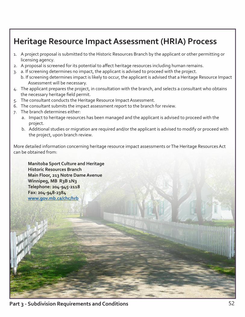
Heritage Resource Impact Assessment (HRIA) Process1. A project proposal is submitted to the Historic Resources Branch by the applicant or other permitting or
licensing agency.2. A proposal is screened for its potential to affect heritage resources including human remains.3. a. If screening determines no impact, the applicant is advised to proceed with the project.
b. If screening determines impact is likely to occur, the applicant is advised that a Heritage Resource Impact Assessment will be necessary.
4. The applicant prepares the project, in consultation with the branch, and selects a consultant who obtains the necessary heritage field permit.
5. The consultant conducts the Heritage Resource Impact Assessment.6. The consultant submits the impact assessment report to the branch for review.7. The branch determines either:
a. Impact to heritage resources has been managed and the applicant is advised to proceed with the project.
b. Additional studies or migration are required and/or the applicant is advised to modify or proceed with the project, upon branch review.
More detailed information concerning heritage resource impact assessments or The Heritage Resources Act can be obtained from:
Manitoba Sport Culture and Heritage Historic Resources Branch Main Floor, 213 Notre Dame Avenue Winnipeg, MB R3B 1N3 Telephone: 204-945-2118 Fax: 204-948-2384 www.gov.mb.ca/chc/hrb
52Part 3 - Subdivision Requirements and Conditions

53
Depending on the location of your land, number of lots proposed and proximity to potential safety hazards, the following agencies may be circulated your application and have additional requirements that will be included in your conditional approval letter.
Railways The standard recommended building setbacks for new residential development in proximity to railway operations are as follows:
freight rail yard 300 metresprincipal main line 30 metressecondary main line 30 metresprincipal branch line 15 metressecondary branch line 15 metresspur Line 15 metres
Setback distances must be measured from the mutual property line to the building face.
Setbacks and berms should typically be provided together in order to afford a maximum level of mitigation. Berms are to be constructed adjoining and parallel to the railway right-of-way with returns at the ends and to the following specifications:
principal main line: 2.5 metres above grade with side slopes not steeper than 2.5 to 1secondary main line: 2.0 metres above grade with side slopes not steeper than 2.5 to 1principal branch line: 2.0 metres above grade with side slopes not steeper than 2.5 to 1secondary branch line: 2.0 metres above grade with side slopes not steeper than 2.5 to 1spur line: No requirement
At a minimum, all new residential developments in proximity to railway corridors must include a 1.83 metre high chain link fence along the entire mutual property line, to be constructed by the owner entirely on private property. Other materials may also be considered, in consultation with the relevant railway and the municipality.
You should consult with the affected railway about any proposed development that may have impacts on existing drainage. Railway corridors/properties with their relatively flat profile are not typically designed to handle additional flows from neighbouring properties and so development should not discharge or direct stormwater, roof water, or floodwater onto a railway corridor.
Any access roads across the railway will be subject to approval from the relevant agency, and must be in compliance with Transport Canada regulations. If the crossing is approved, the owner may be required to execute a license agreement with respect to the terms and conditions of the crossing.
Appropriate legal agreements and restrictive covenants registered on title are also recommended to secure the construction and maintenance of any required mitigation measures, as well as the use of warning clauses and other notification requirements.
For more information, consult the Guidelines for New Development in Proximity to Railway Operations available at www.proximityissues.ca.
Other Agency Requirements
Part 3 - Subdivision Requirements and Conditions

54
PipelinesThe pipeline right-of-way should be kept out of the proposed subdivision area where possible. If this is not feasible, development setbacks from the right-of-way will be required. Additional authorizations and agreements may also be required prior to development or construction. If your proposed subdivision is in proximity to a pipeline, it will be circulated to the appropriate agency for comment. You will receive notice of the agency’s easement and development requirements.
Conservation Districts Subdivisions should generally comply with Integrated Watershed Management Plans adopted by the regional conservation district, and should not adversely impact district facilities. Conditions requested by the conservation district may include drainage right-of-ways, lot grade and/or drainage plans, incorporation of green space design for water storage, and the developer obtaining permission to cross existing facilities.
For more information, visit www.gov.mb.ca/waterstewardship/agencies/cd or the Manitoba Conservation Districts Association at www.mcda.ca.
Canada PostCanada Post generally provides recommendations or requirements on multi-lot subdivisions. Conditions include that:• the developer consult with Canada Post on the placement of community mailboxes • required concrete pads and curb depressions are constructed• notification to purchasers respecting mail delivery is provided
For more information, please consult the Delivery Planning Standards Manual for Builders and Developers available at https://www.canadapost.ca/cpo/mc/assets/pdf/business/standardsmanual_en.pdf.
School DivisionsNew or intensified residential development must comply with The Planning and Land Dedication for School Sites Act. Subdivisions proposing four lots or more will be circulated to the local school division and Public SchoolsFinance Board (PSFB) for review. This will ensure that schools in the area have the capacity to accommodateadditional students resulting from new housing developments. The act requires the subdivision applicant, school division and PSFB to consult with one another. This consultation should result in a subdivision design that, where necessary, provides a school site that meets the needs of the school division and PSFB.
Part 3 - Subdivision Requirements and Conditions

55

Subdivision Registration
56
PART 4

Certificate of Approval and Registration
Once all conditions in the conditional approval letter are completed, the approving authority will sign the MylarsTM and prepare a Certificate of Approval. These are required to register your subdivision with Land Titles.
A Certificate of Approval is valid for one year, but may be extended for an additional year upon request prior to the expiry date on the certificate.
The following signatures are also required on a plan of subdivision: • the registered owners • all encumbrancers (persons with a legal interest
in a property) if a road, lane or public reserve is being created on the plan (This will be noted on your conditional approval letter under Requirement B, if required.)
• the registrar-general of Land Titles • the examiner of surveys
A plan of survey requires only the signature of the examiner of surveys, and sometimes planning (CRP or the approving authority). Your surveyor or lawyer can assist you in obtaining the required signatures.
Land Titles registration fees apply to the plan and all accompanying registrations. Transfers may be taxable. Fees are subject to change. Currently, the base fee for most registrations, including plans, is $87. For more information on the LTO fee schedule and the tax calculator, visit the LTO website: www.tprmb.ca/tpr/land_titles/lto_offices/fees.html.
Additional documents to be filed with a plan of subdivision or survey may include:
• a Registration Details Application (RDA) form • duplicate titles for all of the affected lands if
they have been issued by land titles • requests for new titles using the land titles
request/transmission form • transfers for any lots to be transferred to new
owners • documents such as caveats or easements which
may be required as a condition of planning approval
• discharges of caveats or mortgages affecting lands to be consolidated
Development agreements must be attached to a caveat. The municipality also has to sign the caveat form.
Registration takes approximately two to three weeks. Plan examination occurs in the Winnipeg and Brandon Land Titles Offices. Registration occurs in the appropriate regional Land Titles office. The examiner of surveys (Winnipeg Land Titles Office or Brandon Land Titles Office) must sign the mylar plans prior to registration. CRP staff should direct you to Winnipeg or Brandon if the examiner of surveys signature is required, or to the regional Land Titles Office if the signature has already been obtained and the plans are ready for registration. Please call the Winnipeg Land Titles Office or Brandon Land Titles Office prior to coming in to get signatures to make sure the examiner of surveys will be available.
57
7/8STEPS
Part 4 - Subdivision Registration
Land Titles Office LocationsPortage Land Titles Office25 Tupper Street NorthPortage la Prairie MB R1N 3K1Phone: 204-239-3306
Dauphin Land Titles Office308 Main Street SouthDauphin MB R7N 1K7Phone: 204-622-2084
Winnipeg Land Titles Office276 Portage AvenueWinnipeg MB R3C 0B6Phone: 204-945-2042
Morden Land Titles Office351 Stephen StreetMorden MB R6M 1V1Phone: 204-822-2920
Neepawa Land Titles Office329 Hamilton StreetNeepawa MB R0J 1H0Phone: 204-476-7040
Brandon Land Titles Office705 Princess AvenueBrandon MB R7A 0P4Phone: 204-726-6279

Part 4 - Subdivision Registration
Summary of Essentials
58
The following flow charts and checklists summarize the major steps and timelines involved in completing your subdivision.

Outline of Subdivision Process
59
subdivision application accepted as completed
application evaluated against criteria
application circulated
planning report to council
public notice by council (if new proposed public road)
decision by council
resolution to reject resolution to approve
approving authority rejects and the applicant cannot appeal the decision
approving authority issues conditional approval
approving authority rejects
appeal to The Municipal Board (applicant may appeal a rejection or conditions of approval)
Municipal Board hearing
Municipal Board approvesapplicant completes all conditions and requirements
approving authority issues Certificate of Approval
Municipal Board rejects
shortened process for minor subdivisions
approving authority issues conditional approval and forwards copies to council and government departments
decision by council or designated employee
resolution to reject
conditional approval becomes null and void
resolution to approve
appeal to The Municipal Board (applicant may appeal conditions of approval)
hire a Manitoba land surveyor to complete a subdivision application map (SAM)
meet with Community and Regional Planning

60
Checklists
1. Essentials for Applying for a SubdivisionThe applicant is required to submit the following to the approving authority. Be as thorough as possible since applications cannot be processed with required items missing.
subdivision application: all applicable questions must be answered and the application signed by the registered owner and applicant
subdivision application fee: a cheque or money order for $475 payable to the Minister of Finance
a Surveyor’s Subdivision Application Map prepared by a Manitoba land surveyor showing:• survey monuments (a minimum of two)• proposed lot(s) with dimensions and area• structures:
including each building/structure nearest to the existing and proposed lot lines a list of additional buildings and structures
• onsite wastewater management systems and distance to proposed lot lines• well• driveway(s)
location of current access, access to proposed lot and any other proposed accesses distance from centre line of current access to next access if on a Provincial Trunk Highway or Provincial Road
• existing above-ground utilities• existing tree line and edge of field• water bodies• all affected registered plans• a list of any encumbrances on the title• any other relevant information
Status of Title from a Manitoba land surveyor or The Property Registry for all land to be included in the subdivision. The Status of Title cannot be more than 30 days old.
61
2. Essentials for Completing Requirements and Conditions All requirements and conditions listed in your conditional approval letter must be completed before the subdivision can be registered at the Land Titles Office. Ensure you have completed the requirements and conditions applicable to your subdivision.
REQUIREMENTS
Certificate of Approval fee paid
Plan of Subdivision or land description provided to CRP
CONDITIONS (to be provided to CRP by applicant)
written confirmation from the municipality that all property taxes are paid
satisfied Council’s conditions of approval (ex: conditional use order, variance order, development agreement, etc.)
written confirmation from the utility company that an easement agreement has been entered into or is not required
written confirmation from the telecommunications company that a right-of-way agreement has been entered into or is not required
written confirmation from Manitoba Sustainable Development – Environmental Operations that the onsite wastewater management system is in compliance with provincial regulations
written confirmation from Manitoba Sustainable Development that a licence has been issued for an engineered storm water management and drainage plan
written confirmation from the Highway Traffic Board or Manitoba Infrastructure that the appropriate highway access permits have been obtained
a copy of the Right-of-Way Agreement prepared by a lawyer
Not all conditions will apply to all subdivisions. Refer to your conditional approval letter to see which specific conditions apply to your subdivision. Additional conditions may be required that are not listed here.

Manitoba Hydro Process for Easement Agreements see page 27
CRP issues conditional approval letter to applicant and forwards a copy to Manitoba Hydro
Applicant hires a surveyor to prepare subdivision plan or land description and forwards to Manitoba Hydro
Manitoba Hydro provides surveyor with easement requirements; Surveyor prepares Plan of Easement
Plans are forwarded to LTO for pre-approval
Manitoba Hydro prepares Easement Agreement and circulates to all utilities for signature
Final package, including trust letter and release of condition are forwarded to the applicant’s lawyer for the applicant’s signature
Average processing time of 6 to 12 months
Lawyer forwards the release letter to CRP and submits Plan of Easement to LTO for registration
MTS Process for Easement Agreements see page 28
CRP issues conditional approval letter to applicant and forwards a copy to MTS
Applicant or surveyor contacts MTS and applies for easement
MTS determines easement requirements
Surveyor creates Plan of Easement
MTS reviews draft Plan of Easement, prepares Easement Agreement and sends them to applicant
Applicant receives and signs Easement Agreement
Average processing time of 3 to 6 months
Signed documents are sent to LTO for registration

63
3. Essentials for Registering an Approved SubdivisionAfter completing the requirements and conditions listed in the conditional approval letter, you may submit your final package to your regional Land Titles Office for registration. Ensure that you have included the following (if applicable):
Certificate of Approval from the approving authority
Plan of Subdivision: Ensure all necessary signatures are obtained including the approving authority, the registered owner(s), the Registrar General and the Examiner of Surveys
or
Plan of Survey: Requires signatures by the approving authority and the Examiner of Surveys
or land description
Registration Details Application (RDA) form
duplicate titles
requests for new titles
transfers for any lots to be transferred to new owners
additional documents to be filed with a plan of subdivision or survey (ex: caveats, easements, etc.)
discharges of caveats or mortgages affecting lands to be consolidated
registration fee of $87 (additional fees may apply)
Not all items will be necessary for all subdivisions. Contact your regional Land Titles Office for more information.

Land Titles Office Examination and Registration Process see page 25
CRP issues conditional approval letter to applicant and forwards a copy to LTO
LTO reviews the conditional approval letter for any changes and enters info into surveys books
Surveyor provides prints of the plan (or land description) to LTO for examination
LTO checks calculations, survey evidence and titles and reviews overall survey
LTO forwards file with comments and corrections to surveyor
Surveyor makes corrections and sends revised plan to LTO
LTO reviews revisions and notifies surveyor to create MylarsTM
Surveyor creates MylarsTM and forwards them to the Approving Authority
Approving Authority waits for applicant to complete all conditions of approval
Approving Authority signs MylarsTM and issues Certificate of Approval
Applicant collects all necessary signatures on MylarsTM and forwards to lawyer for registration
Lawyer forwards MylarsTM and registration documents to LTO; LTO registers plan and issues titles
Average processing time of 3 to 6 months
64
All plan examination occurs in the Winnipeg or Brandon Land Titles Office. The Examiner of Surveys must sign the MylarsTM prior to registration of the plan in one of the regional Land Titles Offices.


Appendix


BeausejourBox 50, L01-20 First StreetBeausejour MB R0E 0C0Phone: 204-268-6058
Brandon1B-2010 Currie BoulevardBrandon MB R7B 4E7Phone : 204-726-6267
Dauphin27-2nd Avenue S.W.Dauphin MB R7N 3E5Phone: 204-622-2115
MordenBox 50075536 Stephen St, Unit AMorden MB R6M 1T7Phone: 204-822-2840
Portage 1-2210 Saskatchewan Ave WPortage la Prairie MB R1N 0X1Phone: 204-239-3348
Selkirk (Interlake)103-235 Eaton AvenueSelkirk MB R1A 0W7Phone: 204-785-5090
Steinbach240-323 Main StreetSteinbach MB R5G 1Z2Phone: 204-346-6240
Thompson604-800 Portage AvenueWinnipeg MB R3G 0N4Phone: 204-945-4988
Planning Districts with Subdivision Approving Authority:
Brandon and Area Planning District(Brandon, Elton and Cornwallis)421 Ninth StreetBrandon MB R7A 4A9Phone: 204-729-2110
Cypress Planning District(Town of Carberry, R.M. of North Cypress-Langford, Village of Glenboro and R.M. of South Cypress)122 Main StreetCarberry MB R0K 0H0Phone: 204-834-6618
Lac du Bonnet Planning District(Town and R.M. of Lac du Bonnet)P.O. Box 309Lac du Bonnet MB R0E 1E0 Phone: 204-345-6724
Red River Planning District (Dunnottar, Selkirk, St. Andrews, St. Clements, West St. Paul and East St. Paul)806-A Manitoba AvenueSelkirk MB R1A 2H4Phone: 204-482-3717
South Interlake Planning District(Stonewall, Teulon, Rockwood and Rosser)P.O. Box 1219Stonewall MB R0C 2Z9Phone: 204-467-5587
Community and Regional Planning(CRP)Offices:
68

Manitoba Indigenous and Municipal RelationsCommunity and Regional Planning
manitoba.ca
June 2017