test wells, topagoruk area, alaska - usgs wells, topagoruk area, alaska by florence rucker co^lins...
TRANSCRIPT

Test Wells, Topagoruk Area, AlaskaEXPLORATION OF NAVAL PETROLEUM RESERVE NO. 4
AND ADJACENT AREAS, NORTHERN ALASKA, 1944-53
PART 5, SUBSURFACE GEOLOGY AND ENGINEERING DATA
GEOLOGICAL SURVEY PROFESSIONAL PAPER 305-D
Prepared and published at the request of ana
in cooperation with the U. S. Department of
the Navy, Office of Naval Petroleum and
Oil Shale Reserves


Test Wells, Topagoruk Area, AlaskaBy FLORENCE RUCKER CO^LINS
With Micropaleontologic Study of the Topagoruk Test Wells, Northern AlaskaBy HARLAN R. BERGQUIST
EXPLORATION OF NAVAL PETROLEUM RESERVE NO. 4 AND ADJACENT AREAS, NORTHERN ALASKA, 1944-53
PART 5, SUBSURFACE GEOLOGY AND ENGINEERING DATA
GEOLOGICAL SURVEY PROFESSIONAL PAPER 305-D
Prepared and published at the request of and
in cooperation with the U. S. Department of
the Navy, Office of Naval Petroleum and
Oil Shale Reserves
UNITED STATES GOVERNMENT PRINTING OFFICE, WASHINGTON : 1958

UNITED STATES DEPARTMENT OF THE INTERIOR
FRED A. SEATON, Secretary
GEOLOGICAL SURVEY
Thomas B» Nolan, Director
For sale by the Superintendent of Documents, U. S. Government Printing Office Washington 25, D. C. - Price 35 cents (paper cover)

CONTENTS
Abstract _ _ ______________ _ __________Introduction- ____________________________Topagoruk test well !____ _ ______________
Stratigraphy _______ _ _______________Gubik formation _ _ ______________Grandstand formation. ____________Topagoruk formation __ _ _________Oumalik formation _ _____________Upper Jurassic rocks______________Middle Jurassic rocks_____________Shublik formation _ ______________Permian rocks _ _________________Red beds. _______________________Middle (or Lower?) Devonian rocks_
Description of cores and cuttings. ______Heavy-mineral analysis.. _ _____________Core analyses. _______________________Oil and gas__________ _ _____________
Oil and gas shows __ _______ ___ _Formation tests. _______ _ _______
Drilling operations. _____________________________Rig foundation- _ ____ _______________Drilling notes- ____ ______ ._ ____ __.Drill and core bits__________________________Drilling mud______ _ _______________________Hole deviation. ____________________________Electric logging and other surveys. ___________Velocity survey _ __________________________
Temperature-measurement studies, Topagoruk test well 1, by Max C. Brewer __ _._________ _____
East Topagoruk test well 1__________________________Stratigraphy ____ __ _ ___ _____________
Gubik formation __ _ _ _ __ _______ __ ____Grandstand formation _ ________ _ __________Topagoruk formation ____ ____ __ _________
Description of cores and cuttings. ________________
Page 265 265267268268268269269269270270270270271271288289290290290290291291291294294300300301
301301302302302302302
East Topagoruk test well 1 Continued Pag«Heavy-mineral analysis___-__-_-_____-_--_---_-__ 307Core analyses.--.------------------------------ 307Oil and gas_________________________ 307
Oil and gas shows______--_------__---_---__- 307Formation test--'___-_-___-_-_-___________ 307
Logistics___________________________________ 307Drilling operations-.------.-.----___-___-__-__ 307
Drill and core bits___________________ 308Drilling mud__________________ _ ___ 308Hole deviation__-_-__--_------_-___-_------ 308Electric logging_______________________ 308
Literature cited______________________________ 309Micropaleontologic study of the Topagoruk 'test wells,
northern Alaska, by Harlan R. Bergquist__ 311Topagoruk test well 1___________-_ ___ 312
Pleistocene deposits_____-_-_-_-___-_-_---_-_ 312Gubik formation (14-50 feet)________ 312
Cretaceous rocks__________________________ 312Verneuilinoides borealis faunal zone (50-
3,900 feet).______.-__ _________ 312Oumalik formation (3,900-6,600 feet) _____ 312
Jurassic rocks._______ __________ _______ 313Upper Jurassic rocks (6,600-7,820 feet)__ 313Middle Jurassic rocks (7,820-8,640 feet)_ 313
Triassic roeks_-___________________________ 313Shublik formation (8,640-9,380 feet) _ - __ '313
Permian rocks (9,380-9,770 feet)_________ 313Red beds (9,770-10,040 feet)___________ 313 Lower(?) or Middle Devonian strata (10,040-
10,503 feet)____________________ 313East Topagoruk test well l________________-_-_-- 313
Pleistocene deposits_-_-___-----_--_--------- 313Gubik formation (17-90 feet)________ 313
Cretaceous rocks__________-_______-_----__ 313Verneuilinoides borealis faunal zone (90
feet to total depth)_________ 313Bibliography of the Micropaleontologic study.----- 314
Index. _.__-_._____._.______..._____---_ 315
ILLUSTRATIONS
PLATE 17. Graphic log of Topagoruk test well 1__ In pocket 18. Graphic log of East Topagoruk test well 1_ In pocket
Page FIGURE 14. Index map of northern Alaska_ _______ 265
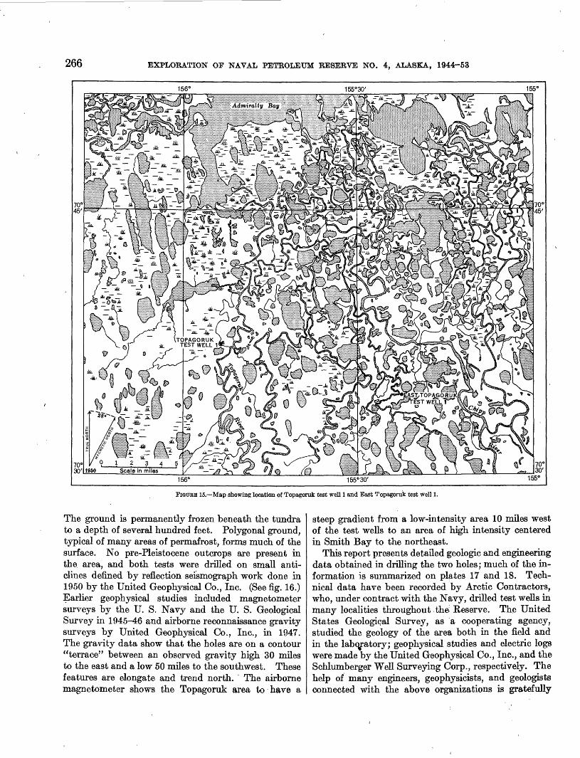
, Page FIGURE 15. Map showing location of test wells.________ 266
16. Structure-contour maps of the Topagorukarea______ ____ ___-__-. 267
17. Relative abundance of heavy minerals.--.-. 289


EXPLORATION OF NAVAL PETROLEUM RESERVE NO. 4 AND ADJACENT AREAS, NORTHERN ALASKA, 1944-53
TEST WELLS, TOPAGORUK AREA, ALASKA
By FLORENCE RUCKER COLLINS
ABSTRACT
Topagoruk test well 1 and East Topagoruk test well 1 were drilled on the northern coastal plain of Alaska in 1950 and 1951, as part of the United States Navy program for petroleum ex ploration in Naval Petroleum Reserve No. 4.
Topagoruk test well 1 was drilled to a depth of 10,503 feet and tested rocks ranging in age from Cretaceous to Devonian. The test well is on a small deeply buried anticline discovered by seismograph survey. The section penetrated consists of shale, siltstone, and sandstone, with several beds of chert conglomerate in the Devonian sequence; the absence of limestone and perme able clastic rocks in beds of Paleozoic age and the lack of all but a minor show of oil resulted in abandoning the test.
East Topagoruk test well 1 was located on an anticline in rocks of the Nanushuk group (Lower and Upper Cretaceous) defined by reflection seismograph. Beneath a thin mantle of the Gubik formation (Pleistocene), the drilling penetrated about
3,500 feet of rock of the Nanushuk group, the upper part of which is dominantly sandstone; the lower part of the sequence is mostly shale. The test was abandoned at a total depth of 3,589 feet; no shows of oil and no commercial shows of gas were found.
INTRODUCTION
Topagoruk test well 1 and East Topagoruk test well 1 were drilled in 1950 and 1951 as part of the petroleum exploration program of the United States Navy in Naval Petroleum Reserve No. 4, northern Alaska. The test wells are approximately 80 miles south-south east of Point Barrow (see fig. 14) in a region of numer ous lakes and marshy tundra (see fig. 15).
A network of meandering streams drain into the Topagoruk and Chipp Rivers and Admiralty Bay.
164'
t SOUTH BAR ROW TEST WELL 12 SOUTH BAR ROW TEST WELL 23 SOUTH BARROW TEST WELL 34 SOUTH BAR ROW TEST WELL 45 AVAK TEST WELL 16 NORTH SIMPSON TEST WELL 1
7 SI HPSON TEST WELL 18 TOPAGORUK TEST WELL t9 EAST TOPAGqf UK TEST WELL 1
10 FISH CREEK TEST WELL 111 KAOLAK TEST WELL 112 MEADE TEST WELL 1
13 OUMALIK TEST WELL 114 EAST OUMALIK TEST WELL 115 SQUARE LAKE TEST WELL'116 TITALUK TEST WELL 117 WOLF CREEK TEST WELL 1 IB WOLF CREEK TEST WELL 2
19 WOLF CREEK TEST WELL 320 GUBIK TEST WELL, t21 GUBIK TEST WELL 222 KNIFEBLADE TEST WELL 123 KNIFEBLADE TEST WELLS 2 AND 2A24 GRANDSTAND TEST WELL t25 UMIAT TEST WELLS 1-11
FIGUEB 14. Index map of northern Alaska showing location of test wells and oil fields.
265
266 EXPLOEATION OF NAVAL PETROLEUM RESERVE NO. 4, ALASKA, 1944-53
156' 155°30'
mmm Admiralty Bay Wif^Mfp^g^ ................................................R......^^............
FIGURE 15. Map showing location of Topagoruk test well 1 and East Topagoruk test well 1.
The ground is permanently frozen beneath the tundra to a depth of several hundred feet. Polygonal ground, typical of many areas of permafrost, forms much of the surface. No pre-Pleistocene outcrops are present in the area, and both tests were drilled on small anti clines defined by reflection seismograph work done in 1950 by the United Geophysical Co., Inc. (See fig. 16.) Earlier geophysical studies included magnetometer surveys by the U. S. Navy and the U. S. Geological Survey in 1945^6 and airborne reconnaissance gravity surveys by United Geophysical Co., Inc., in 1947. The gravity data show that the holes are on a contour "terrace" between an observed gravity high 30 miles to the east and a low 50 miles to the southwest. These features are elongate and trend north. The airborne magnetometer shows the Topagoruk area to have a
steep gradient from a low-intensity area 10 miles west of the test wells to an area of high intensity centered in Smith Bay to the northeast.
This report presents detailed geologic and engineering data obtained in drilling the two holes; much of the in formation is summarized on plates 17 and 18. Tech nical data have been recorded by Arctic Contractors, who, under contract with the Navy, drilled test wells in many localities throughout the Reserve. The United States Geological Survey, as a cooperating agency, studied the geology of the area both in the field and in the laboratory; geophysical studies and electric logs were made by the United Geophysical Co., Inc., and the Schlumberger Well Surveying Corp., respectively. The help of many engineers, geophysicists, and geologists connected with the above organizations is gratefully

TEST WELLS, TOPAGORTJK AREA, ALASKA 267
156° 155°30'
A. SEISMIC HORIZON IN SHALLOW CRETACEOUS ROCKS
\»EAST TOPAGORlfit^ ^ TEST WELL 1
B. SEISMIC HORIZON IN LOWERMOST CRETACEOUS ROCKS
156° 155°30' EXPLANATION
Fault, approximately located; questioned where inferred. U, upthrown side; D,down- thrown side
Structure contours, dashed where inferred. Contour intervals 50 and 100 feet; datum is mean sea level
0 1
Scale in miles
C. SEISMIC HORIZON IN ROCKS OF PALEOZOIC AGEUnited Geophysical Co., Inc. 1950
FIGUEB 16. Structure-contour maps of the Topagoruk area.
acknowledged. Microfossils were identified by Harlan R. Bergquist, and the stratigraphic distribution of fossils in the test wells of northern Alaska will be pre sented by him in another chapter of this series. Mol- lusks were identified by Ralph W. Imlay, and plants, by James M. Schopf. Fish remains were studied by D. H. Dunkle, of the United States National Museum. The heavy-mineral data in this report is part of a regional study of the heavy-mineral zones by Robert H. Morris.
TOPAaORUK TEST WELL 1
Location: Lat 70°37'30" N., long 155°53'36" W.Elevation above sea level: Ground, 28 feet; kelly bushing, 42 feet.Spudded: June 15, 1950.Completed: September 28, 1951, dry and abandoned.Total depth: 10,503 feet.
Topagoruk test well 1 is the second deepest test well drilled in Naval Petroleum Reserve No. 4; only Oumalik test well 1, about 50 miles south, is deeper (Robinson,

268 EXPLORATION OF NAVAL PETROLEUM RESERVE NO. 4, ALASKA, 1944-53
1956). The drilling penetrated rocks ranging in age from Quaternary to Devonian. It is on a small buried anticline having about 150 feet of closure on Permian rocks at a depth of 9,500 feet and about 100 feet of closure on beds near the base of the Cretaceous strata. (See fig. 16.) The anticline, which was defined in 1950 by reflection seismograph, is not present in the shallower Cretaceous rocks (fig. 16). Regional studies (Payne and others, 1951) and seismic surveys indicate a rapid thickening of rocks of Paleozoic and Mesozoic age as the beds dip southward from the structurally high area near Point Barrow. Greater knowledge of the stratigraphy, including the presence and location of unconformities and suitable reservoir conditions, was necessary to evaluate the petroleum possibilities of the northern part of the Reserve. In the Topagoruk area the rocks of Paleozoic age were thought to be present within reach of the drill. The Lisburne group, a thick sequence of Mississippian rocks exposed in the Brooks Range to the south, was the deepest objective of this test. In the area of outcrop these beds include porous limestones and dolomites, some of which have a strong petrolif erous (?) odor (Bowsher and Dutro, 1957.) In Topagoruk test well 1, however, these rocks are absent, and beds of shale and conglomerate of Devonian age are unconformably overlain by red beds of unknown age which in turn are overlain by impermeable siliceous sandstone of Permian age. The beds of Mesozoic age, as well as the older rocks, did not contain oil or gas in commercial quantities; the rare sandstone beds in the Jurassic and Triassic sequence did not have any shows of oil or gas, and although some beds of the Cretaceous have good reservoir properties and one sandstone below 5,960 feet possibly contains a small amount of gas, the electric log shows them to be water bearing.
STRATIGRAPHY
Stratigraphic units in Topagoruk test well 1 are as follows:Pleistocene: Depth (feet)
Gubik formation______________________ 14-50Cretaceous:
Grandstand formation_______________ 50-1,350Topagoruk formation______________ 1,350-3,900Oumalik formation_______________ 3,900-6,600
Jurassic:Upper Jurassic rocks_ __ ____ ___ _ 6,600-7,820 Middle Jurassic rocks.___.__________ 7,820-8,640
Triassic:Shublik formation. _______________ 8,640-9,380
Permian rocks__________________ 9,380-9,770Red beds (age undetermined)____________ 9,770-10,040Middle (Lower?) Devonian rocks.-______ 10,040-10,503
GUBIK FORMATION
Approximately 40 feet of unconsolidated sand of the marine Gubik formation (Pleistocene) overlies indu rated Cretaceous rocks in this test well. The very fine to medium sand is composed of well-rounded to sub- rounded, clear, white, and yellow quartz grains with some yellow and black chert pebbles. In many places, including East Topagoruk test well 1, the Gubik formation contains marine microfossils. None were found in this well, however, and the sand is correlated with the Gubik formation on the basis of lithology. The contact between this and the underlying Grand stand formation is placed at 50 feet. One sample representing the sediments from 14 to 57 feet was made up primarily of Gubik material, with a little sand and coal from the Cretaceous rocks below, and the contact is arbitrarily placed near the bottom of the interval.
GRANDSTAND FORMATION
The Grandstand formation is distinguished from the overlying Gubik formation by color, greater angularity, greater consolidation of the sand, presence of coal and clay ironstone, and its distinctive micro- fauna. (See p. 311.) The only representative of the Nanushuk group (Gryc and others, 1956) in the Topagoruk area, the Grandstand formation, is Early Cretaceous in age.
This formation is composed primarily of marine sandstone, but it also contains a large amount of marine clay shale and a few thin beds of coal. The sandstone beds range from a few feet to 50 feet in thickness and are commonly separated from other sandstone beds by only 1 or 2 feet of clay shale. The typical sandstone is light gray, has a salt-and-pepper appearance, and is calcareous in part. Effective porosity (Tickell, 1939, p. 26) ranges from 11 to 27 percent, and air permeability, from impermeable to 316 millidarcys. (See table on p." 289.) The sand stone is medium to fine grained, usually well sorted, and composed of subangular to subrounded grains of white and clear quartz and some gray chert and dark rock fragments. The grains have low sphericity and are commonly frosted. Mica, carbonaceous material, and pyrite are rare. Clay shale in beds iHtO feet thick is more common in the upper part of the formation than near the base. The clay shale is medium gray, silty in part, nonmicaceous, and noncalcareous and commonly contains laminae of siltstone or sandstone. Thin coal beds, concentrated between 300 ajid 550 feet and from 850 to 1,050 feet, make up a minor part of the formation and indicate minor regressions of the

TEST WELLS, TOPAGORUK AREA, ALASKA 269
sea in which the rest of the formation was deposited. Clay ironstone nodules are scattered through the beds above 1,200 feet and are especially common between 550 and 1,000 feet.
The Grandstand formation and the underlying Topagoruk formation contain microfossils typical of the Verneuilinoides borealis faunal zone (see page 311); the Topagoruk formation, however, is dominantly siltstone and clay shale, whereas the Grandstand formation is dominantly sandstone. The contact is arbitrarily placed at 1,350 feet below the base of the sandy sequence although deposition was continuous and the change from shale to sandstone is gradual.
TOPAQORUK FORMATION
The type section of the marine Topagoruk formation (Lower Cretaceous) has been established (Gryc and others, 1956) as the beds penetrated in drilling Topa goruk test well 1 between 1,350 and 3,900 feet. The formation is composed of medium- to medium-dark-gray and clay shale a few thin beds and laminae of medium-gray siltstone; it also contains beds of sand stone most of which are less than 10 feet thick.
The clay shale is micaceous, silty, and noncalcareous; it contains a few scattered carbonaceous partings and carbonized plant particles. Most of it has poor to fair shaly cleavage. The medium-gray siltstone is present in thin beds, laminae, and small lenses in the shale and decreases gradually with depth from about 25 percent of the rock to less than 10 percent. It is very argillaceous, slightly calcareous in part, and micaceous; some is crossbedded at a low angle. The sandstone is very fine grained, except for some minor fine-grained beds, and is concentrated in the upper 800 feet in 1- to 20-foot beds and in one bed about 60 feet thick. Rare sandstone beds, a few inches to 10 feet thick, are present to a depth of 3,300 feet. The sand stone is medium light gray, silty, and argillaceous; a few beds are slightly to very calcareous, and most are slightly micaceous. The sand grains are subangular to subrounded, and the composition is similar to that of the sandstones of the overlying Grandstand formation. Some of the clay, silt, and sand were deposited in irregular streaks and lenses. Bands of silt or sand intermingled with clay impart a marbled appearance and probably reflect contemporaneous deformation caused by slumping of unconsolidated sediments.
The Verneuilinoides borealis foraminiferal assemblage is present in much of the formation (see p. 311), and at 3,249 feet a specimen of Cleoniceras (n. subgen.) n. sp., an ammonite of Albian age, was recovered.
At 3,900 feet the Topagoruk formation in this well lies on the underlying Oumalik formation with a slight
429371 58 2
angular unconformity. The shale above 3,900 feet is horizontal or very gently dipping, whereas the shale of the Oumalik formation below that depth dips as much as 8°. This unconformity can be traced elsewhere in the Reserve by means of seismic records. Lithologi- cally, the two formations are similar, but the shale of the Topagoruk is generally slightly softer and lighter in color and tends to break into more equidimensional, less angular fragments than the older shale. The un derlying Oumalik formation also contains a different microfaunal assemblage.
OUMALIK FORMATION
The marine Oumalik formation (Lower Cretaceous) is composed almost entirely of medium-dark to dark- gray clay shale and claystone. The rock is slightly silty and micaceous in part and may contain carbona ceous particles and a few laminae of argillaceous silt- stone. The sandstone in the lower part of the forma tion (between 5,000 and 6,600 feet) is slightly darker than that in the overlying formations and is composed of angular to subangular very fine grains of clear quartz, with rare white quartz and dark rock fragments. Some of the sandstone has a brownish tinge, the result of a yellowish-brown stain on the quartz grains. The sandstone beds are commonly less than 10 feet thick and have no shows of oil; but one thicker bed, at 5,960-5,987 feet, was slightly oil stained. It was im permeable, however, and a formation test recovered no oil or gas.
UPPER JURASSIC ROCKS
Between core 55 at 6,510 feet and core 56 at 6,743 feet both lithology and fauna change. The exact depth at which they change is difficult to determine, owing to contamination of the ditch samples by caving shale, but it is probably close to 6,600 feet. Below it, Upper Jurassic rock consisting of dark marine clay shale is present to a depth of 7,820 feet. It is easily dis tinguished from the overlying Oumalik formation by its grayish-black color, absence of siltstone and sand stone laminae, abundant pyrite, and especially, the quartz and chert grains. These grains are fine sand to granule sized, are very well rounded, pitted or polished clear quartz, and are scattered singly or in small pockets through the shale. Smooth, very well- rounded gray and black chert grains of medium sand to granule size are also randomly distributed through the rock, although they are rare. The black shale matrix contains almost no silt and the rare particles of mica are very minute. Grains of bluish-green glauconite are rare to common. At the base of the unit is a glauconite sandstone composed of about 75 percent of grayish-green glauconite in a black clay matrix that

270 EXPLORATION OF NAVAL PETROLEUM RESERVE NO. 4, ALASKA, 1944-53
also contains a small amount of very fine-grained sub- angular quartz. Sandstone higher in this sequence, at 6,800 feet, is represented only by rare chips of medium- to fine-grained glauconitic and pyritic sandstone of well-rounded clear quartz grains. A distinctive and prolific microfauna, as well as a mollusk from 7,060 feet, establishes the age of the beds as Late Jurassic. (See p. 281.)
MIDDLE JURASSIC BOCKS
Beneath the Upper Jurassic rocks is 100 feet or more of medium-gray siltstone which is argillaceous, non- calcareous, and very slightly micaceous and has abun dant irregular discontinuous patches of medium-dark- gray clay shale. It is underlain by clay shale beds that are dark gray and micaceous and that contain abun dant minute pyrite streaks and lines an inch or less long. These beds constitute an 820-foot sequence of Middle Jurassic rocks, between 7,820 and 8,640 feet, in Topa- goruk test well 1. A core at 8,103-8,113 feet contained ammonites (Pseudolioceras? sp. and Tmetoceras sp., identified by Ralph W. Imlay) which are typical of the lower part of the Middle Jurassic (Lower Bajocian). The ammonites normally are near the base of the Mid dle Jurassic, and some of the rock below 8,113 feet may be of Early Jurassic age. No Early Jurassic fossils were found, however; and as the rock below the ammonites is similar to that above them, the whole sequence is here designated as Middle Jurassic.
SHUBLIK FORMATION
Ostracodes, echinoid spines, and pyritic pelecypods present in ditch samples from 8,640 feet downward in dicate that the top of the Shublik formation of Late Triassic age is close to 8,640 feet. Upper Triassic pelecypods Halobia sp. and Monotis sp. and Triassic Foraminifera (see p. 313) were also recovered from this formation. These beds are poorly represented by the ditch samples, which are badly contaminated with cavings. Two cores are composed of dark-gray slightly pyritic clay shale having a few laminae of medium- light-gray very calcareous siltstone, and both the ditch samples and the electric log indicate that most of the formation is the same type of rock. The only other rock types noted in the samples were a few thin beds of siliceous sandstone at 8,720-8,790 feet, a thin bed of very fine-grained glauconitic sandstone at 8,820 feet, dark-brownish-gray limestone at 9,160 feet, and rare dark-gray calcareous siltstone below 8,960 feet. Below 9,100 feet the electric log shows some "kicks" in the re sistivity curve and a gradual increase in the sponta neous-potential curve that were not reflected in the samples.
PERMIAN ROCKS
Permian strata in this test well, first found at ap proximately 9,380 feet, are composed of light-gray sandstone and siltstone; underlying rocks, also con sidered to be Permian, include conglomerate and mot tled claystone of red and gray, as well as sandstone and siltstone similar to that above the conglomerate.
The uppermost 140 feet consists of light-gray sili ceous sandstone that is dolomitic in the upper part and interbedded with siliceous siltstone near the base. The sandstone is very fine grained and composed primarily of subangular white and clear quartz of moderate sphericity, commonly frosted; some grains, however, are clear angular quartz and have low sphericity. Some of the sand grains have been enlarged by silica deposited in optical continuity, while others have been roughened by solution. Dark rock fragments and minute carbonaceous particles are rare, and mica is absent. Irregular laminae of medium-dark-gray sili ceous clay shale are present, although uncommon. Brachiopods (Lingula sp.) are present, and coelocanth fish teeth from 9,438 feet (see p. 283) establish the age of the beds. The lower 13 feet of the rock contains several beds of siliceous claystone that are a few inches to nearly 4 feet thick. Some of the claystone and some of the siltstone interbedded with it are a mottled medium gray and grayish red. In some places the red parts fade gradually into the gray; elsewhere the color boundaries are sharp, although they do not coincide with changes in texture or grain size in the rock.
Beneath the mottled claystone is conglomerate com posed predominantly of white chert pebbles, with a few pebbles of gray and black chert, in a matrix of clear and white quartz sand and siliceous cement. The pebbles are Yi-% inch in diameter and are subround to well rounded. The conglomerate is underlain by a 50-foot bed of light-gray very fine- to fine-grained very siliceous massive sandstone, and that in turn is underlain by medium-dark-gray clay shale and siliceous siltstone. The base of the sequence, at 9,770 feet, is marked by the abrupt appearance of red beds.
RED BEDS
Beds of brick-red to grayish-red claystone, siltstone, and sandstone, with a few thin beds of red chert con glomerate and rare interlaminated red and green shale, are interbedded from 9,770 to 10,040 feet. No fossils were found in these rocks, and their age is unknown. They are beneath rocks of Permian age, and are sepa rated by an angular unconformity from Devonian strata. The red beds are similar lithologically to red beds in the Siksikpuk formation (Permian?) that crop out in

TEST WELLS, TOPAGOftUK AREA, ALASKA 271
the Brooks Range to the south (Patton, 1957), but the evidence is too scanty and the distance too great to warrant correlating the two sequences.
MIDDLE (OR LOWER?) DEVONIAN ROCKS
An angular unconformity separates the Devonian rocks from the overlying red beds: cores show that beds of Devonian age dip 35°-60°, whereas the younger strata dip 8° or less. The Devonian strata are composed of approximately equal amounts of interbedded medium- gray chert conglomerate and dark-gray carbonaceous shale and claystone. The conglomerate is very sili ceous and sandy, and contains subangular white, gray, and black chert pebbles %-% inch in diameter in the upper part, increasing to a maximum of 2K inches near the bottom of the hole. The matrix is coarse to fine chert sand, with some silty and argilla ceous material, well cemented by additional silica. The pebbles are either scattered or in beds. Shaly streaks, carbonaceous films or partings, and minute cubes and irregular patches of pyrite are present. The clay shale is grayish black and slightly silty and siliceous, with discontinuous carbonaceous partings, some of which are covered with carbonized fragments of plants identified by James M. Schopf as Middle (Early?) Devonian in age. Pyrite nodules are rare. The rocks are in durated by siliceous cement, but show no sign of meta- morphism.
The bottom of the hole, at 10,503 feet, is in chert conglomerate.
DESCRIPTION OF CORES AND CUTTINGS
The description of the rocks penetrated in Topagoruk test well 1 and in East Topagoruk test well 1 is based on an examination of cores and ditch samples. Some ditch samples were composed of sandstone through depths which are represented on the electric log by curves typical of clay shale; in Topagoruk test well 1, ditch samples below 4,200 feet were contaminated by caving of rock higher up in the hole. The graphic logs (pis. 17 and 18) generally show the lithology inferred from the electric logs, as that is believed to be more accurate. The material was described dry, and colors were deter mined by comparison with the Rock Color Chart (Goddard, 1948). Ah1 depths are measured from the top of the kelly bushing.
Clay ironstone is a yellowish-gray to grayish-yellow and grayish-orange dense hard argillaceous rock with conchoidal fracture; it is sideritic and usually reacts with cold dilute hydrochloric acid.
Abundance of microfossil specimens mentioned at the beginning of each core sampled is defined as follows: 1-4 very rare; 5-11 rare; 12-25 common; 26-50 abun dant; over 50, very abundant.
Lithologic description
[Where no cores are listed, description is based on cutting samples]
Core
____
___-
_ __ _
____
_____ _______
___ _
___ _
_ __ _
_ ___1
Depth (feet)
0-1414-57
57-120
120-130
130-140
140-170
170-180180-190190-200
200-240
240-260
260-300
300-302302-312
Description
Kelly bushing to ground level.Sand, very fine- to medium-grained, with
a few coarse grains; composed of verywell-rounded to subrounded (rarelysubangular) clear, white, and yellowquartz, with some yellow and blackchert. Very rare coal (?) particles alsopresent. The top of the Grandstandformation placed at 50 ft.
No samples received. Arctic Contractors' well geologist John Bollenbacherlists "clay shale with coal interbedsand interbeds of limestone and calcareous silts."
Coal, with some greenish-gray very finegrained very silty very calcareoussandstone, of subangular clear andwhite quartz and rare chert grains.
Samples from 120 to 200 ft contain alarge amount of cement and chert-pebble contamination from the surface.
No sample. Well geologist reports"shale, medium-hard, gray, with finesand interbeds and few thin coalseams" between 111 and 302 ft.
Sandstone, light-olive-gray, very fine- tofine-grained, very calcareous, hard, ofangular to subangular white and clearquartz and a few dark grains. Pyriteand coal rare.
Coal with some sandstone as above.Sandstone as above, with some coal.Coal, with small amount of calcareous
sandstone, grading to sandy limestone.Sandstone, very fine-grained; composed
of subangular white quartz. Rarefragments of hard black shale at 220-230 ft. Well geologist reports clay shale.
Sandstone as above, and very sandylimestone, grading to very calcareoussandstone with a few fragments ofblack soft carbonaceous shale.
Sandstone, light-gray, very fine-grained;composed of subangular white quartzwith rare dark rock fragments.
No sample.Recovered 10 ft: Microfossils absent.
5 ft, sandstone, light-gray, finegrained, salt-and-pepper, slightlycalcareous, massive, moderatelywell-indurated. Thin streaks ofcarbonaceous material in lower 6 in.Friable near base. At 304 ft effective porosity and air permeabilityparallel to the bedding 11.0 percentand 5.17 millidarcys; perpendicularto the bedding they are 11.1 percentand impermeable, respectively. Carbonate content at 304 ft 16.38 percent by weight.

272 EXPLOKATION OP NAVAL PETKOLEUM EESEEVE NO. 4, ALASKA, 1944-53
Litholoffic description Continued
Core
_--_
________
____
____
____
_-__
_---____
----____
________
____
____
____
____
____
____
Depth (feet)
312-330
330-340340-350
350-360
360-380
380-390
390-410
410-420420-440
440-460460-470
470-480480-510
510-520
520-530
530-540
540-550
550-560
560-590
590-596
Description
1 ft 8 in., interbedded medium-light-gray clay shale and light-gray silt-stone.
3 ft 4 in., sandstone, light-gray, finegrained, very friable, with some thinstreaks of carbonaceous material.Thin bed of coal at top of sandstone.Beds approximately flat lying.
Sandstone as at top of core 1 with somecoal in the lower part and a smallamount of black shale.
Sandstone, light-gray, very fine-grained.Coal, with small amount of light-
yellowish-gray sandstone and greenish-gray very fine- to fine-grained sandstone.
Sandstone, light-yellowish-gray and light-greenish-gray, very fine- to finegrained, with some coal and blackshale containing laminae of coal.
Coal and light-greenish-gray sandstone,with small amount of black clay shaleand rare pyrite.
Sandstone and rare coal; some clay shalesuggested by electric log.
Coal, with some sandstone and blackclay shale.
No sample.Sandstone and coal, with rare slightly
calcareous clay ironstone and pyrite;clay shale suggested by electric log.
Sandstone with a small amount of coal.Sandstone (the electric log suggests much
clay shale) and rare coal and siltstone;latter very sandy, argillaceous, andcalcareous.
No sample.Clay shale and sandstone (clay shale in
lower part), with small amount ofvery sandy calcareous argillaceoussiltstone. Some coal and black clayshale in bottom 10 ft.
Sandstone as above, and clay shale, butwith more siltstone and some clayironstone and black shale.
Clay shale, medium-gray, silty, non-calcareous, nonmicaceous, hard, withsome sandstone, clay ironstone, andsiltstone; pyrite common.
Sandstone , and clay shale, with smallamount of coal and ironstone; pyrite,black clay shale, and siltstone rare.
Sandstone and siltstone with some coal;small amount of clay shale and ironstone.
Coal, with little medium-gray clay shaleand clay ironstone.
Siltstone, coal, sandstone, gray and blackclay shale, and ironstone.
No sample.
Litholoffic description Continued
Core
2
________
____
____
__-_
____
___-
____
____
____
_-_.
____----
____
________
Depth (feet)
596-608
608-610610-640
640-670
670-690
690-720
720-740
740-760
760-780
780-790
790-820
820-840
840-860860-870
870-880
880-890890-900
Description
Recovered 10 ft: Microfossils absent.Sandstone, light-gray, fine- to medium-
grained, salt-and-pepper, friable,with some streaks of carbonaceousmaterial, plant fragments in mud-stone streaks, and abundant fragments of Inoceramus shells. At 603ft effective porosity 27.2 percent,and air permeability 316.2 milli-darcys, parallel to bedding; perpendicular to bedding, 26.2 percent and219.8 millidarcys, respectively.
No sample.Sandstone, greenish-gray, very fine- to
fine-grained, slightly calcareous; composed of subangular white and clearquartz grains; clay ironstone rare;siltstone rare at base.
Sandstone as above, medium-gray clayshale, and small amount of coal, silt-stone, and clay ironstone.
Sandstone, with small amount of medium-gray clay shale and clay ironstonethroughout and small amount blackshale in upper 10 ft.
Clay shale, medium-gray, silty, noncal-careous, with some sandstone and rareclay ironstone.
Sandstone, medium-light-gray, very finegrained, silty, slightly calcareous, withsmall amount of clay shale in lowerpart.
Limestone, medium-dark-gray, very siltyand argillaceous, with small amount ofsandstone.
Sandstone, as above, with small amountof limestone, clay shale, and clay ironstone.
Sandstone, gray and black shale, andcoal.
Clay shale, gray and black, with somesandstone.
Sandstone, medium-light-gray, fine- tomedium-grained , salt- and-pepper,silty, very slightly argillaceous, veryslightly calcareous, friable; composedof subround to subangular clear andwhite quartz with small amount ofgray and black rock fragments. Somegray shale, and a little clay ironstonealso present.
Sandstone as above, with coal.Sandstone as above, with a Jittle clay
ironstone and black clay shale in thelower part.
Coal, black and gray clay shale, rarelimestone fragments.
Coal, some limestone, and clay shale.Coal with a little sandstone and rare clay
ironstone and black shale.

TEST WELLS, TOPAGOBTJK AREA, ALASKA 273
Lithologic description Continued
Core Depth (feet)
900-910910-911911-919
919-920920-930
930-940
940-950
950-970
970-990
990-1, 010 1, 010-1, 030
1, 030-1, 040
1, 040-1, 060 1, 060-1, 070 1, 070-1,100
1,100-1, 170
1,170-1,190
1, 190-1, 200
1, 200-1, 209
Description
Coal and salt-and-pepper sandstone.No sample.Recovered 8 ft: Microfossils very
abundant.Claystone, light-gray, with hackly to
subconchoidal fracture. Feels slip pery. Marcasite nodule 1 in. across at bottom of core. Small pelecypod shell fragments present, including Arctica? sp., and Thracia stelcki McLearn, and Corbula, identified by Ralph W. Imlay.
No sample. Clay shale, gray and black, with some
coal and clay ironstone. Clay shale, medium-gray, with rare
sandstone, siltstone, and ironstone. Clay shale, medium-gray, with a little
clay ironstone and coal. Coal, black, shiny, with blocky fracture,
and small amount of clay ironstone, and black and medium-gray clay shale.
Coal and gray clay shale, with some clay ironstone and salt-and-pepper sand stone.
Coal, gray clay shale, and sandstone. Coal, with small amount of gray clay
shale. Clay shale, medium-gray, with some coal
and sandstone. No sample.Coal, sandstone, and clay shale. Sandstone, light-olive-gray, very fine
grained, very silty and argillaceous, very calcareous, with some gray clay shale and a little coal.
Sandstone as above with some clay shale and clay ironstone at 1,110-1,125 ft and 1,145-1,150 ft.
Sandstone as above, with siltstone and clay shale; sample composed mostly of Fiber! ex.
Sandstone, as above, with gray clayshale and clay ironstone.
Recovered 9 ft: Microfossils absent. Sandstone, light-gray, fine- to medium-
grained, salt-and-pepper, very slightly calcareous, moderately fri able, with trace of mica; grains subangular.
Depth (feet)
,204P«..,204N»., ,209P .209N...
Effective porosity (percent)
26.023.121.316.6
200.4128.9169.1108.8
Content Air per- of
meability carbonate (milli- minerals
darcys) (percentby
weight)
14.7
13.2
» P, parallel to bedding. * N, normal to bedding.
Core
Lithologfa description Continued
Depth (feet)
1, 209-1, 210 1, 210-1, 290
1, 290-1, 320
1, 320-1, 340
1, 340-1, 370
1, 370-1, 380
1, 380-1, 450
1, 450-1, 490
1, 490-1, 501
1, 501-1, 590
1, 590-1, 610
1, 610-1, 640
1, 640-1, 720 1, 720-1, 740 1, 740-1, 770
1, 770-1, 790
1, 790-1, 800
Description
No sample.Sandstone, light-olive-gray, very fine
grained, very silty and argillaceous, calcareous; and medium-light-gray medium- to fine-grained salt-and- pepper slightly calcareous sandstone; grades to very sandy and argillaceous medium-gray siltstone, which is slightly calcareous and slightly mica ceous toward base.
Siltstone as above, with some very fine-grained sandstone.
Sandstone (in the upper part), siltstone, and clay shale.
Siltstone and clay shale, with small amount of sandstone. Top of the Topagoruk formation at 1,350 feet.
Clay shale, with small amount of silt- stone and very fine-grained sandstone and salt-and-pepper sandstone; pyrite common.
Clay shale, medium-dark-gray, non- calcareous, with small amount of siltstone and rare streaks of sandstone; some pyrite.
Siltstone, light-olive- to olive-gray, slightly micaceous, slightly calcareous; streaks of sandstone at 1,480-1,490 ft (shale indicated by electric log).
Recovered 11 ft: Microfossils very abun dant.
Clay shale, medium-gray, with hackly cleavage, rare silty partings, abun dant plant fragments; beds flat ly ing. Inoceramus sp. and Pleuromya sp. shell fragments present.
Siltstone and clay shale as above; pyrite common.
Sandstone and siltstone, with some clay shale; pyrite rare.
Clay shale and siltstone, with rare streaks of sandstone.
Clay shale, with small amount siltstone.Siltstone, sandstone, and clay shale.Clay shale and siltstone with streaks of
sandstone.Sandstone, light-yellowish-gray, very
fine-grained, very silty, noncalcareous, with many tan, black, and yellow subangular and subrounded grains. Streaks of clay shale and siltstone in bottom 15 ft.
Recovered 5 ft: Microfossils common. 1 ft 6 in., sandstone, medium-light-
gray, very fine-grained, silty, argil laceous, slightly micaceous, non- calcareous. Sand grains subangular, largely clear quartz with some white and dark-gray grains. Effective porosity 18.1 percent; air permea bility 11.8 millidarcys,

274 EXPLOKATION OF NAVAL PETROLEUM RESERVE NO. 4, ALASKA, 1955-53
Lithologic description Continued
Core
....
____
____
7
^_._
Depth (feet)
1, 800-1, 810
1, 810-1, 860
1, 860-1, 910
1, 910-1, 935
1, 935-1, 960
1, 960-2, 040
2, 040-2, 087
2, 087-2, 097
2, 097-2, 100
Description
1 ft 2 in., clay stone, medium-gray,silty, micaceous, very slightly calcareous.
2 ft 4 in., sandstone, medium-light-gray, very fine- to fine-grained,silty, argillaceous, micaceous,slightly calcareous (dolomitic?),with evenly bedded laminae markedby scattered flakes of carbonizedplant remains on partings. Dip 5°.Impermeable to air; effective porosity 17.7 percent.
Clay shale and sandstone, light-yellowish-gray, very fine-grained.
Clay shale and siltstone with streaks ofmedium-gray sandstone.
Sandstone, medium-gray, clay shale andsiltstone.
Clay shale, medium-dark-gray, noncalcareous, with small amount of silt-stone and sandstone. Pyrite rare.
Sandstone, with small amount of silt-stone and clay shale.
Clay shale, medium- to medium-dark-gray, noncalcareous; and medium-gray slightly calcareous siltstone.
Sandstone, medium-gray, very finegrained, silty, slightly calcareous, with rare carbonaceous partings and smallamount sandy limestone in bottom10ft.
Recovered 10 ft: Microfossils rare. 5 ft, sandstone, medium-gray, very
fine-grained, very silty, very calcareous; grades to very calcareoussandy siltstone at base; 2% ft belowtop of core is 4-in. layer of medium- dark-gray to light-olive-gray slightly to very calcareous clay- stone, with small slickensides (dip ping approximately 45°) ; lower part broken into angular to subround fragments, in matrix of sandstone.Minute vertical calcite veinletsoccur at base of section.
1 ft 10 in., clay shale, medium-dark-gray, slightly micaceous, slightlycarbonaceous, with scattered laminae and lenses of medium-graysiltstone. Beds dip less than 3°.
3 ft 2 in., sandstone as in lower partof core; 2 thin 1-in. layers of clayshale. Ditrupa sp. present,
No sample,
Lithologic description Continued
Core
_ _ _ _
_ _ __8
.___.___
....
9
----
.___
Depth (feet)
2, 100-2, 200
2, 200-2, 350
2, 350-2, 370
2, 370-2, 3902, 390-2, 399
2, 399-2, 4002, 400-2, 560
2, 560-2, 565
2, 565-2, 5802, 580-2, 620
2, 620-2, 637
2, 637-2, 642
2, 642-2, 6502, 650-2, 680
2, 680-2, 7402, 740-2, 7502, 750-2, 8302, 830-2, 900
2, 900-2, 940
Description
Clay shale, medium-dark-gray, slightlymicaceous, slightly carbonaceous, withsome Sandstone and siltstone;
Clay shale, medium-dark-gray, noh-calcareous, very slightly micaceous inpart, with some medium-gray siltstone,slightly calcareous in part.
Sandstone, medium-light-gray, very finegrained, with small amount of silt-stone and clay shale.
Clay shale and siltstone, grains of coal.Recovered 9 ft: Microfossils very abun
dant.Clay shale, medium- to medium-dark-
gray, nottcalc&reous; commonly hashackly cleavage; some laminae and thin lenses of silty medium-gray shale. Small patches of sandy carbonaceous silt and carbonized plantfragments throughout. Beds approximately flat lying.
No sample.Clay shale and siltstone. Siltstone has
grains of coal. Siltstone decreases inabundance from almost half thesamples at 2,400 ft to absent at 2,530ft; small amount, partly occurring aslaminae in the shale, present from2,530 ft to 2,560 ft.
Sandstone, very fine-grained, with silt-stone and clay shale.
Clay shale, as above.Sandstone, medium-gray, medium-fine
grained, salt-and-pepper, friable, very calcareous; grades to very fine grained; silty in bottom 10 ft.
Clay shale, with small amount of silt-stone.
Recovered 3 ft: Microfossils common. 1 ft 6 in., siltstone, medium-dark-gray,
very argillaceous, slightly micaceous, noncalcareous; grades into unit below.
1 ft 6 in., clay shale, medium-dark-gray, noncalcareous, with some slightly silty streaks.
No sample.Clay shale, with sandstone at 2,655-
2,660 ft and small amount of siltstonewith carbonaceous partings.
Clay shale, with some siltstone at base.Sandstone, with clay shale and siltstone.Clay shale, with streaks of siltstone.Clay shale as above, with interbedded
sandstone and siltstone.Clay shale, with rare laminae of medium-
light-gray siltstone.
TEST WELLS, TOPAGORIIK AREA, ALASKA 275
Lithologic description Continued
Core
10
_.__
__-__ __ _
__._
11
._-_
....
Depth (feet)
2, 940-2, 950
2, 950-2, 9702, 970-3, 0103, 010-3, 0303, 030-3, 050
3, 050-3, 220
3, 220-3, 240
3, 240-3, 249
3, 249-3, 2503, 250-3, 2603, 260-3, 310
3, 310-3, 325
3, 325-3, 420
Description
Recovered 9 ft: Microfossils abundant.Clay shale, medium-dark-gray, non-
calcareous, very slightly micaceous,with thin (as much as l l/z in.) beds,lenses, and laminae of medium-light-gray argillaceous noncalcareouspoorly cross-bedded siltstone, containing rare fine carbonaceous partings. Siltstone makes up approximately 15 percent of the totalrecovered core.
Clay shale with rare laminae of siltstone.Clay shale and siltstone.Clay shale, with rare siltstone laminae.Clay shale and salt-and-pepper sand
stone.Clay shale with scattered laminae and
thin beds of siltstone.Clay shale, with thin beds of medium-
light-gray very fine-grained sandstone, carbonaceous laminae, and raresiltstone.
Recovered 6 ft: Microfossils rare.1 ft, claystone, medium-gray, very
silty, micaceous, slightly calcareous,with flakes of carbonaceous materialscattered throughout.
2 ft 5 in., claystone, very silty,micaceous, noncalcareous, withabundant flakes of carbonized plantsscattered throughout.
5 in., siltstone, medium-light-gray,very sandy, slightly calcareous,with carbonaceous partings and thinbeds (as much as one-half inch) ofmedium-gray clay shale.
2 ft 2 in., clay shale as in core above,but with increasing amount ofmica and flakes of carbonized plantremains toward base of core. A1-in. layer of medium-gray veryargillaceous noncalcareous sandstone, with abundant flakes ofcarbonaceous material, occurs 3 in.above lower end of core. Beds lieapproximately flat. Cleoniceras (n.subgen.) n. sp. found at 3,249 ftwas identified by Ralph W. Imlay.
No sample.Clay shale with thin sandstone beds.Clay shale with scattered siltstone
laminae.Sandstone, light-gray, very fine-grained,
silty, argillaceous, slightly to verycalcareous. Composed of subangularclear and white quartz, gray chert,and gray and black rock fragments;carbonaceous partings rare.
Clay shale with siltstone laminae.
Lithologic description Continued
Core
____
____1213
....
14
____
____
_ ___
15
__ __
16
____
17
....
Depth (feet)
3, 420-3, 430
3, 430-3, 530
3, 530-3, 5403, 540-3, 5503, 550-3, 560
3, 560-3, 804
3, 804-3, 807
3, 807-3, 8103, 810-3, 870
3, 870-3, 900
3, 900-4, 100
4, 100-4, 110
4, 110-4,345
4, 345-4, 348
4, 348-4, 632
4, 632-4, 635
4, 635-4, 785
Description
Clay shale with sandstone and siltstoneinterbedded.
Clay shale with thin beds and laminaeof siltstone.
Clay shale with rare siltstone laminae.No recovery.Recovered 2 ft 6 in.: Microfossils com
mon.Clay shale, medium-dark-gray, non-
calcareous, with rare laminae andthin lenses of medium-light-grayargillaceous siltstone. Dip less than3°.
Clay shale, medium-dark- to dark-gray,slightly micaceous, with rare siltstonelaminae.
Recovered 2 ft: Microfossils rare.Clay shale, medium-gray to medium-
dark-gray, noncalcareous, withlaminae and thin (less than 2 in.)beds of medium-light-gray sandyargillaceous slightly calcareous(dolomitic?) siltstone, with partingsof medium-dark-gray clay shale.Dip less than 2°. Siltstone totals15 percent of recovered core.
No sample.Clay shale, medium-dark- to dark-gray,
slightly micaceous, with rare laminaeof medium- to medium-light-graysiltstone.
Clay shale with thin beds and laminaeof siltstone. Top of Oumalik formation at 3,900 feet.
Clay shale, medium-dark-gray, slightlysilty, noncalcareous, with siltstonelaminae.
Recovered 8 in.: Microfossils absent.Claystone, medium-dark-gray, slightly
silty, micaceous, noncalcareous; con-choidal fracture.
Clay shale as above, with very raresiltstone laminae.
Recovered 3 ft: Microfossils very rare.Clay shale, medium-dark-gray, slightly
micaceous, noncalcareous, with somelaminae of light-gray siltstone.Beds dip 3°.
Clay shale as above, dark-gray;micaceous in part, with very raresiltstone laminae and thin bed of veryfine-grained sandstone at 4,550 ft.
Recovered 3 ft: Microfossils very rare.Clay shale, medium-dark-gray, non-
calcareous, with very rare slightlysilty medium-gray laminae of silt-stone. Beds have excellent shalycleavage and dip 2°.
Clay shale as in, qore 17.

276 EXPLORATION OF NAVAL PETROLEUM RESERVE NO. 4, ALASKA, 1944-53
Lithologic description Continued
Core
18
___-1920
____21
22
____23
24
25
Depth (feet)
4, 785-4, 790
4, 790-4, 8954, 895-4, 8994, 899-4, 902
4, 902-5, 0055,005-5,010
5, 010-5, 016
5, 016-5, 091
5, 091-5, 094
5, 094-5, 098
5, 098-5, 183
5, 183-5, 193
Description
Recovered 5 ft: Microfossils absent.Clay shale, medium-dark-gray, slightly
micaceous, noncalcareous, with poorshaly cleavage, dipping 3°-7° (?).Laminae of medium-gray argillaceous siltstone rare; small pyritenodules very rare.
Clay shale as in core 18.No recovery.Recovered 2 ft 6 in. : Microfossils absent.
Clay shale, medium-dark-gray, slightly micaceous, noncalcareous, withpoor shaly cleavage dipping 3°-6°(?). Laminae and thin beds (lessthan one-half inch thick) of medium-light-gray argillaceous siltstonemake up less than 5 percent of therock.
Clay shale as in core 20.Recovered 1 ft 2 in. : Microfossils absent.
5 in., sandstone, medium-light-gray,very fine-grained, very silty andargillaceous, slightly calcareous,with irregular intercalations andstreaks of medium-dark-gray clayshale totaling about a quarter ofthe rock.
9 in., clay shale fragments, medium-dark-gray, very slightly micaceous,noncalcareous.
Recovered 6 in.: Microfossils absent.Fragments of dark-gray clay shale and
medium-light-gray sandstone asabove.
Clay shale as in core 24 below.No recovery.Recovered 4 in. : Microfossils absent.
»/'Jay shale, medium-dark-gray, slight- iy silty, micaceous (largely biolite), noncalcareous, with minute flakes of carbonaceous material scattered throughout. Beds approximately flat lying.
Clay shale as in core 24, with laminaemedium- to medium-light-gray silt-stone and rare laminae very finegrained silty sandstone.
Recovered 9 ft: Microfossils absent.9 in., claystone, medium-dark-gray,
very slightly silty, noncalcareous,with flakes of biotite and carbonaceous material scattered throughout. Top one-half inch of rockmedium-light-gray very fine-grainedvery silty argillaceous noncalcareoussandstone, with sharp sandstone
Lithologic description Continued
Core
___
2627
____
and clay contact dipping 18°, 1
Depth (feet)
5, 193-5, 268
5, 268-5, 2785, 278-5, 2885, 288-5, 360
Description
3 in., sandstone, medium-light-gray,very fine-grained, very silty andargillaceous, slightly micaceous, non-calcareous; rarely cross-bedded, withsome bedding planes and minutetension cracks marked by a concentration of dark carbonaceous (?)material.
2 in., clay shale, medium-dark-gray,silty, micaceous, with intercalationsof medium-light-gray silty argillaceous sandstone at base.
3 ft 2 in., sandstone, medium-light- tolight-gray, very fine-grained, verysilty and argillaceous, slightly calcareous in part; composed of sub-angular to angular grains of clearor white quartz, some dark grains,and a few flakes of mica and carbonaceous material. Possible cross-bedding plane (marked by slightlylighter color and coarser texture)dips 25°. Contemporaneous deformation marked by distortedpartings of medium-dark-gray clay.Thin intraformational conglomerateof medium-dark-gray clay shale at5,186 ft.
1 ft 6 in., interbedded and interlami-nated clay shale and very finegrained sandstone as above, withirregular lenses of clay; crossbedded;some beds distorted contemporaneously with deposition.
3 ft 2 in., sandstone, very fine-grained,very silty and argillaceous, as above,in part with abundant laminae and thin beds of clay distorted con temporaneously with deposition. These alternate and intergrade with sections that have subparallel car bonaceous partings spaced from 1 mm to 1 cm apart, which dip 28°-33°; some are offset by small (asmuch as one-half inch displacement)reverse faults.
Clay shale, medium-dark-gray, partlyslightly silty, micaceous, noncalcareous, with laminae of siltstone andvery fine-grained very silty sandstone]pyrite very rare.
No recovery.No recovery.Clay shale, medium-dark-gray, with
laminae of siltstone and medium-light-gray very fine-grained silty argillaceous calcareous sandstone; slightincrease in siltstone in lower 20 ft.

TEST WELLS, TOPAGORUK AREA, ALASKA .277,'
Lithologic description Continued
Core
28
29
30
____
31
______-.
32
____
____33
Depth (feet)
5, 360-5, 365
5, 365-5, 370
5, 370-5, 375
5, 375-5, 475
5, 475-5, 480
5, 480-5, 5405, 540-5, 575
5, 575-5, 582
5, 582-5, 680
5, 680-5, 6815, 681-5, 688
Description
Eecovered 2 ft 6 in. : Microf ossils absent.Claystone, grading to clay shale, me
dium-dark- to dark-gray, finely micaceous, with some laminae andsmall lenticles of medium-light-grayargillaceous noncalcareous siltstone;some laminae slightly distorted orbroken with minute "step" faults.Dip of siltstone laminae is 2°-30°;dip of shaly cleavage 8° or less.
Eecovered 6 in. : Microfossils absent.Claystone, medium- dark-gray, finely
micaceous in part.Eecovered 2 ft: Microfossils absent.
Claystone, medium-dark-gray, withsubconchoidal fracture ; lenticles andlaminae of medium-gray siity clayand medium-light-gray siltstonerare.
Clay shale as in core 30 above with rarepyrite.
Eecovered 5 ft: Microfossils absent.Clay shale, medium-dark-gray, finely
micaceous, with laminae and partings of medium-gray silty clay shaleand medium-light-gray siltstone;some of rock crossbedded. Bedswith very good shaly cleavage dipunder 1°.
Clay shale as in core 31 above.Clay shale 'with thin beds sandstone,
light-gray, very fine-grained, silty, argillaceous, micaceous, partly calcare ous; grains composed of subangularwhite quartz with some white andgray chert and rare black rock frag ments; contains clay laminae.
Eecovered 7 ft: Microfossils absent.Claystone, medium-dark-gray, finely
micaceous; irregular fracture; at 5,577 ft is 2 in. of distorted inter-bedded medium-light-gray siltstone and medium-dark-gray clay shale;at 5,578 ft is 6 in. of thin siltstonebeds with clay laminae, showingdistorted bedding, an intraforma-tional conglomerate of siltstonefragments, and small normal faults(up to %-in. displacement) whichoutline slumped blocks 1-2 in. indiameter.
Clay shale as in core 32 above (withsandstone beds in the lower 15 ft);pyrite common in sample at 5,290 ft.
No sample.Eecovered 6 ft 6 in. : Microfossils absent.
Claystone, medium-dark-gray, slightlymicaceous, noncalcareous; irregular
Lithologic description Continued
Core
________
34
3536
37
38
-__-
39
Depth (feet)
5, 688-5, 6905, 690-5, 780
5, 780-5, 790
5, 790-5, 7955, 795-5, 800
5, 800-5, 802
5, 802-5, 860
5, 860-5; 865
5, 865-5, 944
5, 944-5, 954
Description
fractures commonly have slicken-sided surfaces. A 6-in. section at5,685 ft has laminae and thin bedsof siltstone and medium-light-grayvery fine-grained micaceous veryslightly calcareous silty sandstone;some distortion probably due tocontemporaneous deformation.
No sample.Clay shale with thin, very silty beds of
sandstone at 5,700, 5,720, and 5,730ft, and siltstone and silty argillaceoussandstone laminae.
Eecovered 6 in.: Microfossils absent.Claystone, medium-dark-gray, very
slightly micaceous, with subconchoidal fracture; rare laminae ofmedium-gray silty clay shale.
No recovery., Eecovered 8 in. : Microfossils absent.
Clay shale similar to the claystone incore 34, but with poor shaly cleavage.
Eecovered 2 ft: Microfossils absent.Clay shale, medium-dark-gray, finely
micaceous, noncalcareous, with goodshaly cleavage. Dip as much as 3°.Interbedded laminae and thin bedsof medium-light-gray partly slightlysandy micaceous very slightly calcareous siltstone, with some 'cross-bedding, total a third of core.
Clay shale with siltstone as in core 37 above.
Eecovered 2 ft 6 in.: Microfossils absent. Claystone and clay shale, medium-
dark-gray, very slightly micaceous,noncalcareous; with a few laminae of medium-gray silty clay shale, distorted (probably by contemporaneous slumping) in upper part. Dip of undisturbed laminae inlower part 3°.
Clay shale as in core 38.
Eecovered 9 ft: Microfossils absent.8 ft, clay shale, medium-dark-gray,
irregularly interlammated with medium-light-gray siltstone with clayforming about two-thirds of the sediment. Very good shaly cleavagedips about 2°. Some silt laminaethicken abruptly to lenses aboutone-fourth inch thick.
1 ft, siltstone, medium-gray, sandy,argillaceous, slightly calcareous; avertical calcite veinlet cuts throughbottom 3 in. of core.
429371 58 3
278 EXPLORATION OF NAVAL PETROLEUM RESERVE NO: 4, ALASKA, 1944-53
Mthotogic description Continued
Gore
40
41
42
43
4445
46
Depth (feet)
5, 954-5, 964
5, 964-5, 967
5, 967-5, 974
5, 974-5, 984
5, 984-5, 9905, 990-6, 000
6, 000-6, 003
6, 003-6, 013
Description
Recovered 10 ft: Microfossils absent.7 ft, interbedded laminae and thin
beds of medium-dark-gray non-calcareous micaceous clay shaleand medium-light-gray sandy argillaceous slightly calcareous silt-stone containing rare carbonaceousflakes. Beds approximately flatlying.
3 ft, sandstone, medium-light-gray,very fine-grained, very silty andargillaceous, micaceous (largely bio-tite), very slightly calcareous, withflakes of carbonaceous material(probably carbonized plant remains) scattered throughout. Faintodor of oil noted.
Recovered 2 ft 6 in.: Microfossils absent.Sandstone as above, but with abun
dant carbonaceous partings in top6 in., and clay laminae and lensesat 5,965 ft.
Recovered 4 ft 3 in.: Microfossils absent.Sandstone, medium-gray, very fine
grained, silty, argillaceous, slightlycalcareous, well-indurated. Faintoil odor present; pale-yellow cutand clear yellow residue in CCU.Sand grains angular, white and clearquartz, frosted in pa^t, and commonly have a slight brownish(bituminous?) surface stain. Raregrains of gray rock fragments andcoal particles also present. At5,972 ft effective porosity 10 percent, but rock is impermeable toair. Carbonate content 2.2 percentby weight.
Recovered 2 ft: Microfossils absent.Sandstone as above.
No recovery.Recovered 8 ft: Microfossils absent.
Claystone, medium-dark-gray, micaceous, noncalcareous, with numerous laminae of medium-gray siltyclay that dip approximately 10°.Vertical smooth-surfaced fracturessplitting sections of core intosubequal parts are common. Clay-stone becomes slightly silty withdepth, and 5,998-5,999 ft is domi-nantly siltstone, although containing some intercalations of clay.
Depth corrected from 6,000 to 6,003feet.
Recovered 8 ft 6 in.: Microfossils absent.Clay shale, medium-dark-gray, mica
ceous, noncalcareous, with laminaeand thin beds of medium-gray siltyclay shale and siltstone which are
lAthologic description Continued
Core
47
48
49
50
___-___-
51
Depth (feet)
6, 013-6, 023
6, 023-6, 033
6, 033-6, 043
6, 043-6, 052
6, 052-6, 1306, 130-6, 1406, 140-6, 150
Description
commonly crossbedded. Verticalsmooth-surfaced fractures common,as in core 45 above.
Recovered 10 ft.: Microfossils absent.Claystone, medium-dark-gray, silty,
very micaceous, noncalcareous; li-thology very uniform except for2-in. section (at 6,018 ft) of siltstonecontaining somewhat distortedlaminae of clay; vertical fractures,as above, common, and core from6,017 ft to 6,018 ft has been split bytwo parallel vertical fractures aboutone-half inch apart.
Recovered 9 ft 6 in.: Microfossils absent.Clay shale, medium-dark-gray, slightly
silty, finely micaceous, noncalcareous, with poor shaly cleavage, anda few vertical, smooth-surfacedfractures as in core 47.
Recovered 10 ft: Microfossils absent.8 ft 3 in., clay shale as above.1 ft 2 in., siltstone, light-olive-gray,
slightly sandy, very slightly calcareous, micaceous, with rare carbonaceous specks.
7 in., clay shale as above.Recovered 3 ft 10 in.: Microfossils
absent.Clay shale, medium-dark-gray, slightly
micaceous, noncalcareous, with goodshaiy cleavage. Dip 4° or less.Thin beds of medium-gray siltstonewith interlaminated and commonlycrossbedded clay laminae increasewith depth.
Clay shale as in core 50.Sandstone as in core 51 below.Recovered 9 ft 6 in.: Microfossils absent.
3 ft 1 in., sandstone, olive-gray, veryfine-grained, silty, argillaceous, micaceous, noncalcareous. Good oilodor. Saturation test of samplefrom 6,141 ft determined petroleumand water percent by volume to be4.81 and 2.84 percent, respectively.At 6,143 ft a light fraction of petroleum made up 0.62 percent of thesample by volume; heavy fraction2.46 percent; water content 2.15percent of same sample. Effectiveporosity at 6,141 ft 11.8 percent;rock impermeable; carbonate^ content 10 percent by weight. Flakesand rare partings of carbonaceousmaterial scattered throughout.Sand grains angular to subangularand commonly frosted, composedlargely of clear quartz, with somewhite quartz and a few brown or

TEST WELLS, TOPAGORUK AEEA, ALASKA 279Lithologic description Continued
Core
52
____
____
Depth (feet)
6, 150-6, 160
6, 160-6, 232
6, 232-6, 270
6, 270-6, 430
Description
gray rock fragments. Many havea faint brownish surface stain(bitumen?) . Glauconite, pyrite, andmica very rare; carbonaceous grainsonly slightly more common. A1-in. bed of clay shale present at6,142ft.
7 in., clay shale, medium-dark-gray,micaceous, noncaicareous, with goodshaly cleavage. Laminae and thinbeds of siltstone, some slightlycrossbedded, occur in lower half.Beds lie approximately flat.
1 in., sandstone as above.% in., clay shale as above.8 in., siltstone, iight-olive-gray, sandy,
argillaceous, slightly calcareous,with carbonaceous flakes and partings concentrated in the upper hah*.
5 ft, clay shale, medium-dark-gray,micaceous, noncaicareous, with goodshaly cleavage in upper 1 ft. Slightlysilty toward base. Fragmental fish(?) remains and very rare flakes ofbituminous material scatteredthroughout. Irregular band }i-%in. wide of medium-gray silty sandstone, dipping approximately 30°,at 6, 149 ft. Sand grains angular tosubangular clear quartz, with brownish surface- stain, as in sandstoneabove.
Recovered 9 ft 6 in.: Microfossils absent.Claystone, to clay shale, medium-dark-
gray, noncaicareous, very slightly silty in part. Irregular laminae and bands of medium-gray silty sand stone and sandy siltstone, dipping as much as 35°, are present and rarelyare distorted by contemporaneous deformation. One band, at 6,157ft, is 4 in. thick, with clay laminaein it; another, at 6,159 ft is 6 in.thick and also contains clay laminae.
Clay shale as in core 52 with some silt-stone beds.
Interbedded sandstone and clay shale.Sandstone is dark yellowish brown,very fine grained, and very slightlycalcareous, with brown (oil?) stain.Grains angular to subangular clearquartz, with some carbonaceous particles, white quartz and dark rockfragments.
Clay shale, medium-dark-gray, nonmica-ceous to very slightly micaceous, asin core 52. Slight amount of sandstone, as above, 6,340-6,350 ft. Electric log suggests presence of bed of
Lithologic description Continued
Core
____
____53
54
55
Depth (feet)
6, 430-6, 440
6, 440-6, 4806, 480-6, 490
6, 490-6, 500
6, 500-6, 510
Description
sandstone at 6,290-6,300, but ditchsamples do not contain any sandstone.
Clay shale as above, and light-yellowish-brown very fine-grained silty sandstone; grades to siltstone of same colorand composition. It is finer grained,lighter in color, and tighter than sandstone at 6,240 ft.
Clay shale as above.Recovered 7 ft 3 in.: Microfossils very
rare.1 ft 7 in., sandstone, light-olive-gray,
very fine-grained, very silty andargillaceous, noncaicareous, withscattered laminae of medium-dark-gray clay. Sand grains similar inshape and composition to those incore 51.
8 in,, interbedded thin beds of sandstone as above and medium-dark-gray clay shale.
1 ft 10 in., siltstone, medium-gray,very argillaceous, slightly sandy,non calcareous; grades into unitbelow.
6 in., claystone, medium-dark-gray,silty; a few very silty streaks dip15°-20°.
1 ft, interbedded sandstone and clayshale as above.
1 ft 8 in., sandstone as above.Recovered 6 ft: Microfossils absent.
1 ft 7 in., interbedded sandstone andclay shale as above.
3 ft 6 in., sandstone, medium-gray, very fine-grained, silty, argillaceous, very slightly calcareous, very uni form. Fair oil odor; yellow cut and residue in CCU. Carbonaceous partings rare in bottom 3 in.; just above base of section is a %-in. bedof fine- to medium-grained siltysandstone with small-scale cross-bedding. Plug made parallel to bedding at 6,498 ft had an effective porosity of 4.72 percent, was impermeable; rock has a carbonate content of 16.5 percent by weight.
11 in., interbedded clay shale andsilty very fine-grained sandstone, asabove, with silty laminae in the clayshale.
Recovered 9 ft 6 in.: Microfossils absent.Clay shale, medium-dark-gray, slight
ly silty, noncaicareous, very micaceous (biotite). Poor shaly cleavage. Rare flakes of bituminous andcarbonaceous material scatteredthroughout. Beds lie approxim atelyflat.

280 EXPLORATION OF NAVAL PETROLEUM RESERVE NO. 4, ALASKA, 1944-53
, Lithologic description Continued
Core
__
____
____
56
57
Depth (feet)
6, 510-6, 555
6, 555-6, 575
6, 575-6, 590
6, 590-6, 620
6, 620-6, 740
6, 740-6, 743
6, 743-6, 753
6, 753-6, 849
6, 849-6, 859
Description
Clay shale, dark-gray, very slightly silty,very slightly micaceous, noncalcareous.Electric log suggests sandstone from6,540 to 6,547 ft.
Sandstone, very fine-grained, silty, argillaceous, very slightly calcareous; composed of angular light-brownish clearquartz.
Clay shale, medium-dark-gray.
Sandstone and clay shale as above. Topof Upper Jurassic rocks placed at6,600 feet.
Clay shale, dark-gray; pyrite rare toabundant; waxy tan clay in somesamples. Shale becomes darker withincreasing depth. Biotite specks intan waxy clay fragment at 6,740 ft.Rare rounded quartz grains as in core56 near base of unit. Sharp lithologicbreak between core 55 and core 56 cannot be determined more accuratelyfrom ditch samples because of contamination of samples by caving ofshale from farther up hole. Electriclog suggests change in lithology near6,700 ft.
No sample.
Recovered 2 ft 6 in.: Microfossils" abun dant.
Clay shale, grayish-black, pyritic;shaly to subconchoidal fracture;clear quartz grains, medium to fine,rounded to very well rounded,polished or with slightly frosted orpitted surfaces, scattered singly or insmall groups through shale. A 1-in.bed of medium-light-gray denseargillaceous limestone occurs 1 in.from top of recovered core.
Clay shale, dark-gray to grayish-black,hard. Pyrite and tan waxy clay common; light-greenish-gray clay fragments rare. Rare quartz grains asdescribed in core 56 above. A 2-mmwell-rounded chert granule at 6,760 ft.Rare fragments of sandstone, medium-to fine-grained, of rounded to well-rounded clear quartz and some blue-green glauconite grains, with calcareous, silty, pyritic matrix, occur from6,790 to 6,810 ft. Pieces of shale withlaminae or small concretions of pyriterare throughout. One piece of pyritecontaining brown soft well-roundedvery fine-sand-size grains found at6,830 ft. Sandstone fragment from6,850 ft contains bituminous flakes.
Recovered 5 ft: Microfossils very rare.
Lithologic description Continued
Core
58-
60
____
___61
Depth (feet)
6, 859-6, 860
6, 860-7, 040
7, 040-7, 0427, 042-7, 052
Description
Clay shale, grayish-black, good shalycleavage, with quartz grains as incore 56 above. Pyrite very rare.Carbonized plant fragment on onebedding plane. Beds approximatelyflat lying.
No sample.There was no recovery from cores 58
(6,927-6,932 ft), 59 (6,932-6,942), 60(6,942-6,950), and the following description of the no-recovery depthsbetween 6,927 and 6,950 are from cuttings only.
Clay shale, grayish-black, hard, withabundant pyrite, in part as concretions or laminae in shale. Fragmentsof tan waxy clay rare to common;rare to abundant rounded clear quartzgrains and a few granules of blackchert are present; fragments of veryfine-grained brown sandstone andsiltstone are common. Slickensideson shale fragments from 6,890 ft,6,900 ft, and 6,930 ft; tan waxy claywith mica particles occurs as laminaein black shale fragment from 6,880 ft.Brown limestone fragments found at6,880 ft and 6,940 ft; a fragment at6,880 ft has a 0.5 mm veinlet of dark- brown quartz. Brown very finegrained sandstone laminae present inblack shale fragments at 6,900 ft and6,940 ft. "Sandstone" made of well-rounded to very well-rounded medium to very fine grains of clear quartzand blue-green glauconite in blackshale matrix common in most samplesbelow 6,930 ft; it forms 5 percent ofsamples at 6,960 ft and 6,980 ft; 25percent of sample at 6,950 ft composed of black shale fragments withsand grains scattered through them.Greenish-gray waxy clay present at6,970 ft. One piece of shale at 6,980ft grades from grayish-black to brownish-black with bituminous (?) flakes.One piece of sandstone at 7,000 ft hasbituminous flakes.
No sample.Recovered 3 ft: Microfossils very abun
dant.. 1 f t 9 in., claystone, grayish-black,
pyritic, with rounded fine to medium sand grains of clear quartz asdescribed in core 56 above.
1 ft 3 in., clay shale, grayish-black.slightly micaceous, pyritic, withquartz grains as described above,Good shaly cleavage; beds lie approximately flat.

TEST WELLS, TOPAGORUK AREA, ALASKA 281
Lithologic description Continued
Core
62
-___
63
Depth (feet)
7, 052-7, 062
7, 062-7, 804
7, 804-7, 814
Description
Recovered 5 ft: Microfossils very abundant.
Clay shale as above. Pelecypod shells,including a specimen at 7,060 ft,which was identified by Ralph W.Imlay as Aucella of. A. rugosa(Fischer), with rare fragmentsthroughout recovered core.
Clay shale, grayish-black, hard, as incore 62 above, with rare pyrite; rarerounded clear quartz grains from7, 062 to 7,550 ft; common to abundant quartz grams from 7,550 to 7,760ft. Coarse to fine well-rounded sand ofclear quartz and glauconite in blackshale matrix common to 7,340 ft, rarefrom 7,340 to 7,760 ft. Black shalewith abundant blue-green glauconitegrains, but no quartz, is rare to common, increasing with depth. From7,560 to 7,760 ft very fine sand grainsof white quartz and small amount ofwhite calcite, angular to subangular,range from rare to abundant and increase with depth. Loose glauconitegrains common from 7,630 to 7,760 ft.Brown limestone common at 7,360 to7,370 ft. Two fragments of large sub-angular quartz (?) grains in pyritematrix found at 7,550-7,560 ft. Ditchsamples below 6,100 ft probably badlycontaminated by cavings and do notrepresent accurately depths fromwhich taken. Electric log shows pattern typical of shale down to 7,760ft. From 7,760 to 7,804 ft, however,is an abrupt large increase in spontaneous potential, matched- by asmaller but equally sudden increasein resistivity. Neither are reflectedin samples, which contain nothingbut black shale through this depth,but curves may reflect change inlithology from shale to type of rockdescribed in core 63.
Recovered 10 ft: Microfossils absent. Glauconite sandstone, grayish-black,
argillaceous, hard, massive. As seen in thin section, it is composed of approximately 75 percent medium to very fine well-rounded grains of grayish-green glauconite. Matrix largely black clay but contains very fine subangular quartz grains. Many of the glauconite grains have brownish rims, and some seem to belargely altered to brownish material.Two or three similarly shaped grainsconsist of yellow earthy mineral,
Lithologic description Continued
Core
__-_
64
65
66
67
____
Depth (feet)
7, 814-7, 829
7, 829-7, 839
7, 839-7, 849
7, 849-7, 8577, 857-8, 020
8, 020-8, 104
8, 104-8, 114
8, 114-8, 215
8, 215-8, 275
Description
and one is reddish; these may belimonite and hematite, respectively.Granular to flaky shiny red mineral,probably hematite, is scatteredthrough core. Abundance of glauconite and hematite vary, withformer decreasing and latter increasing co 40 percent in some sections.Hematite-rich fragment has specificgravity of 3.35.
Gray and black shale. Top of MiddleJurassic rocks at 7,820 ft.
Recovered 10 ft: Microfossils absent.5 ft, siltstone, medium-gray, argilla
ceous, well-indurated, very slightlymicaceous, noncalcareous, withabundant irregular laminae of dark-gray clay totaling about 25 percentof the rock. Grades into unit below.
5 ft, siltstone as above but medium-light-gray; lighter color due to decrease in clay laminae, which are aminor constituent. Effective porosity of sample from 7,835 ft 6.4percent; air permeability less than1 millidarcy.
Recovered 8 ft 4 in. : Microfossils absent.Siltstone with clay intercalations as
above.No recovery.Siltstone as in cores 63 and 64 above,
probably with some black and grayshale. Well cuttings composed almostentirely of black shale, most of whichprobably caved from overlying beds.
Clay shale, black and medium-dark-gray,with rare pyrite. Electric log hascurve typical of shale, except for somesmall sharp curves in resistivity between 8,035 and 8,060 ft. No material found in ditch samples to accountfor these sharp "kicks"; much of therock in the samples may be contamination from above.
Recovered 7 ft 6 in. : Microfossils absent. Clay shale, medium-dark-gray, finely
micaceous, noncalcareous, fair shaly cleavage. Beds lie flat. Mi nute streaks and lines of pyrite common throughout. Middle Jur assic ammonites (Pseudolioceras? sp. and Tmetoceras sp.) identified by Ralph W. Imlay (1955, p. 82, p. 89),
Clay shale, some similar to core 67, withrare light-gray and brown sandstoneand siltstone at top.
Siltstone, medium-gray, very argillaceous, with some clay shale.

282 EXPLORATION OF NAVAL PETROLEUM RESERVE NO. 4, ALASKA, 1944-53
Lithologic description Continued
Core
68
____
____
____
_ _
___
69
___
Depth (feet)
8, 275-8, 629
8, 629-8, 634
8, 634-8, 721
8, 721-8, 790
8, 790-8, 830
8, 830-8, 840
8, 840-8, 917
8, 917-8, 921
8, 921-9, 100
Description
Clay shale as in core 67, with somemedium-dark-gray argillaceous silt-stone between 8,410 and 8,440 ft, and8,560 and 8,629 ft.
Recovered 5 ft: Microfossils absent.Claystone, medium-dark- to dark-
gray, sparsely and finely micaceous,noncalcareous, hard; rare finely disseminated carbonaceous flakes;slightly greasy luster under microscope. Thin laminae and lenticlesof light-gray hard siltstone common. Dip less than 3°.
Clay shale and clay stone as above;from 8,675 to 8,721 ft resistivity curveof electric log shows pronounced increase in resistivity; spontaneous potential curve has only slight outwardcurve. No change in lithology foundin ditch samples which are probablylargely composed of cavings fromabove. Top of Shublik formation at8,640 feet.
Sandstone, olive-gray, very fine-grained,silty, siliceous, possibly with inter-bedded siltstone and clay shale.
Although ditch samples are medium-' dark-gray clay shale (with one pieceof tan limestone at 8,790 ft, andbetweeni 8,809 and 8,830 ft one pieceof white sandstone with glauconitegrains, as in the ditch sample from8,830 to 8,840 ft), self-potential curveon electric log shows as large a valueas it does opposite siliceous sandstoneabove.
Sandstone, white, very fine-grained, withsome grains of glauconite.
Clay shale as above, in well cuttings;electric log has a sharp peak inresistivity curve from 8, 860 ft to 8,880ft, which is not reflected in samples.
Recovered 2 ft % in.: Microfossils common.
% in., siltstone, medium-light-gray,very sandy, very calcareous, hard,with glauconite grains and minutestreaks of carbonaceous material.
2 ft, clay shale, dark-gray, veryslightly micaceous, with fair shalycleavage; dip less than 3°. Triassicpelecypod (Monotis or Halobia)impressions common.
Clay shale as above; siltstone present insamples below 8,960 ft is medium darkto medium light gray, very sandy,argillaceous, very calcareous, withcarbonaceous grains in darker fragments.
Litliologic description Continued
Core
_-__
____
70
____
71
72
_.__73
Depth (feet)
9, 100-9, 160
9, 160-9, 170
9, 170-9, 200
9, 200-9, 202
9, 202-9, 380
9, 380-9, 416
9, 416-9, 426
9, 426-9, 428
9, 428-9, 4339, 433-9, 455
Description
Siltstone, as in 8,960-9,100 ft above.Piece of gray chert and one of pinkish-gray chert were noted in samplesbetween 9,140 and 9,160 ft.
Limestone, dark-brownish-gray, veryslightly sandy and carbonaceous, withpiece of gray and black chert.
Siltstone, very calcareous, as above, withlimestone and chert in upper part.
Recovered 1 ft: Microfossils absent.Clay shale, dark-gray, silty, slightly
micaceous, calcareous, slightly py-ritic, hard, with numerous laminaeof medium-gray highly calcareoussiltstone. Beds lie approximatelyflat.
Interbedded calcareous siltstone andblack and gray shale as above.Fragments of light-brown and med-dium-light-gray sandstone, brownlimestone, and glauconite rare.
Sandstone, light-gray, very fine-grained,siliceous. Top of Permian rocks at9,380 feet.
Recovered 5 ft: Microfossils absent.Sandstone, white, very fine-grained.
Grains predominantly subarigular,with moderate sphericity, of whiteand clear quartz, commqnly frosted.Some grains are clear angularquartz of low sphericity; dark rockfragments and minute carbonaceousparticles present, though rare; py-rite and mica absent. Rock contains 16.2 percent of dolomite (?),probably cement. Silica also present as cementing material. Pelecy-pods rare. Plugs made paralleland perpendicular to bedding at9,420 ft impermeable to air andhad effective porosity of 6.9 and6.61 percent, respectively.
Recovered 1 ft 6 in,: Microfossilsabsent.
Dolomite (?) with sand grains asabove, very light-gray, slightlysilty. Carbonate content 51.2 percent (largely dolomite?).
White calcareous sandstone as in core 72.Recovered 22 ft: Microfossils absent.
3 in., clay shale, medium-gray, siliceous, slightly micaceous, hard,with fair shaly cleavage. Shaleflakes in washed sample range fromdark gray to light brownish gray,apparently becoming lighter withincrease in silica. Pyrite absent.
21 ft 9 in., sandstone, light-gray, veryfine-grained, silty, very hard, tightly

TEST WELLS, TOPAGORUK AREA, ALASKA
Lithotogic description Continued I Litholoffio description Continued
283
Core
74
_ _ __75
76
Depth (feet)
9, 455-9, 458
9, 458-9, 4599, 459-9, 462
9, 462-9, 492
Description
cemented with varying proportionsof silica and carbonates. Carbonatecontent at 9,435 ft 6.8 percent, at9,450 ft 5.26 percent, at 9,453 ft 27percent. Vertical fractures present; one has coating of minuteclear quartz crystals. Irregularpartings of medium-dark-gray siliceous slightly micaceous clay shalescattered throughout, especially inlower part, and concentrated in 2-to 3-in. bands at 9,434 ft, 9,436 ft,9,444 ft, and 9,448 ft. Brachiopod(Lingula sp.) shells and impressionsrare, increasing to common at9,438 ft and 9,448 ft. Coelocanthfish teeth from 9,438 ft have beendescribed by D. H. Dunkle , of theU. S. National Museum, as beingsimilar to ones reported from formations of the Permian in Wyomingand Texas.
Recovered 3 ft: Not sampled for micro-fossils.
Sandstone as above, with clay concentrated in upper foot. Thin sections from upper part of core showno evidence of metamorphism.Some grains enlarged by depositionof silica in optical continuity withgrain; more commonly, grains havebeen roughened by solution. Matrix, which completely fills inter-grain areas, is mixture of clay andamorphous silica, with a little chert.Mineral grains, other than quartz,very rare.
No sample.Recovered 3 ft: Not sampled for micro-
fossils.Sandstone, medium-gray, very fine
grained, very silty, slightly argillaceous, .very siliceous, nonmica-ceous, noncalcareous, massive, withstreaks of siltstone and irregular claypartings, especially in lower part.
Recovered 30 ft: Microfossils absent.1 in., intraformational conglomerate
of small, usually flat, subround tosubangular dark-gray clay shalepebbles as much as one-half inch indiameter, scattered in matrix ofsandstone which is continuous withsandstone immediately below. Topof conglomeratic layer sharper andmakes an irregular contact withsandstone described in core 75.Scattered pebbles also present inupper; 2 in. of 8-ft sandstone beddescribed below.
Core
77
Depth (feet)
9, 492-9, 522
Description
21 ft 10M in., siltstone, medium-dark-gray, very sandy, argillaceous, verysiliceous; medium-gray siliceoussandstone at top grades into thesiltstone. Intercalations and irregular partings of dark-gray claycommon. Siltstone breaks irregularly, but vertical fractures extendthrough much of core. Small br%-chiopods (Lingula sp.) rare exceptat 9,468 ft, 9,470 ft, and 9,48^ ft,where they are common.
Yz in., intraformational conglomerateas described above, but dippingirregularly 15°-20°.
8 ft, sandstone, medium-gray, as incore 75, grading into siltstone as described above. A 2-in. bed of medium-gray siliceous clay shale withpoor shaly cleavage present at 9,491ft.
Recovered 30 ft: Microfossils absent.11 ft 1 in., siltstone as in core 76, with
one ^-in. bed and two 2-in. beds ofmedium-gray very fine-grainedslightly silty very siliceous non-micaceous noncalcareous massivesandstone between 9,500 and 9,501ft. Vertical fractures common,many slightly oil stained from oiladded to drilling mud.
11 in., sandstone, medium-gray, veryfine-grained, very silty, very siliceous, noncalcareous; grades intomedium-gray very silty very siliceous noncalcareous clay shale, withconchoidal fracture.
4 in., clay shale, dark-gray, slightlysiliceous, with silty laminae; goodshaly cleavage; beds lie approximately flat.
1 ft 3 in., sandstone as above, withtwo }4-in. bands of clay partings 4in. and 11 in. below top.
1 ft 2 in., siltstone as at top of core.1 ft 2 in., claystone, grayish-red, very
silty; contact with siltstone aboveirregular, gradational; base of clay-stone marked by intermingling ofgray- and red-mottled clay and silt-stone; irregular reddish patches persist in underlying gray silty sandstone for about 6 in.
2 ft 3 in., sandstone,1 reddish-gray andmedium-gray, very fine- to finegrained, silty, very siliceous, non-calcareous; grades into unit below.
9 in., siltstone, very argillaceous,medium-gray, very siliceous, non-calcareous, grading into unit below.
284 EXPLORATION OF NAVAL PETROLEUM RESERVE NO. 4, ALASKA, 1944-53
Lithologic description Continued
Core
____78
Depth (feet)
9, 522-9, 5239, 523-9, 538
Description 1
3 ft 9 in., claystone, dark-gray, verysilty, very siliceous, noncalcareous,with scattered minute carbonaceousand pyritic patches, increasing insize with depth. Irregular to sub-conchoidal fracture.
1 ft 7 in., claystone, medium-gray,silty, very siliceous, noncalcareous,with small scattered sandy patchesin upper part, and some smallmedium-dark-gray patches of carbonaceous material.
9 in., claystone as above, very silty,mottled grayish-red, which increaseswith depth.
8 in., claystone as above, but grayish-red throughout, grades into unitbelow.
1 ft, claystone as above, with grayand red marbled appearance.
3 in., claystone, medium-light-gray,with some small red patches, verysiliceous, noncalcareous, with raresilt and sand grains and rare faintslickensides.
6 in., claystone, marbled grayish-redand gray, silty, siliceous.
6 in., claystone, medium-light-gray,nonsilty, siliceous, slightly waxyappearance.
1 ft 1 in., sandstone, very fine- to finegrained, silty, slightly siliceous,argillaceous, noncalcareous; gradesinto unit below.
6 in., conglomeratic sandstone, medium- to medium-dark-gray, fine- tomedium-grained, silty, siliceous,with scattered subround black chertpebbles up to one-half inch diameter,and small dark-gray carbonaceouspatches.
6 in., sandstone as in interval overlying conglomeratic sandstone.
No sample.Recovered 15 ft: Not sampled for micro-
fossils.1 ft 5 in., (3 in.), conglomerate, light-
gray, with white, gray, and altered,chalky-appearing chert pebbles upto one-fourth inch in diameter in amatrix of coarse to fine clear quartzsand with siliceous cement.
1 ft 3 in., (6 in.), sandstone, light-gray,fine- to medium-grained, very siliceous; composed of subround toangular clear quartz and white
See footnote at end of table.
Lithologic description Continued
Core Depth (feet) Description 1
chert grains with very rare sub-angular white chert pebbles up toone-fourth inch in diameter. Contact with conglomerate above andbelow irregular, but not gradational.
4 ft 8 in., (5 in.), conglomerate, light-gray. An ill-defined band, about1 in. wide, half pebbles and halfsandstone matrix, marks changefrom sandstone to conglomerate.Pebbles and matrix in this upper 1in. are similar to those of conglomerate below, difference being intheir proportions. Conglomeratepebbles predominantly white chert,commonly altered (before deposition in the conglomerate) to achalky appearance, though hardness has not been appreciablyaffected. About 20 percent of thepebbles are black and gray chert;1 or 2 light-green chert pebbles anda few gray or brownish-gray siliceous siltstone pebbles also present.Chert ranges in size from granules topebbles three-fourths inch in diameter, though most pebbles are between one-eighth inch and one-fourth inch across; they are angularto subrounded, and usually of lowsphericity. Most of the sand is fineto coarse and is of clear and whitequartz and a small amount of chertin a siliceous matrix that constitutes25 percent of the rock.
6 in., (6 in.), sandstone, light-gray,very fine- to coarse-grained, conglomeratic, siliceous, with scatteredchert pebbles up to one-eighth inchin diameter, especially in lowest 1 in.
1 in., (1 in.), sandstone as in 1 ft 3 in.unit above; grades into unit below.
1 in., (1 in.), sandstone as in 6 in.unit above; grades into unit below.
2 ft 8 in., (11 in.), conglomerate, withwhite, black, and gray chert pebblesup to 1 in. in diameter (averageabout one-half inch in diameter),subround to well rounded, of lowsphericity, with a few rounded siliceous sandstone and siltstone pebbles.Matrix constitutes approximately15 percent of the rock, and is composed of fine to coarse grains of clearand white quartz, with some chert,and siliceous cement.
See footnote at end of table.

TEST WELLS, TOPAGORUK AREA, ALASKA 285
LithotOffic description Continued
Core
79
Depth (feet)
9, 538-9, 539
9, 539-9, 557
Description i
3 in., (3 in.), conglomerate as abovebut with 70 percent of matrix, 30percent of pebbles; pebbles rarelymore than one-half inch in diameter.
1 in., (1 in.), conglomerate as above,but pebbles more numerous (up to50 percent of the rock) and larger(as much as 1 in. in diameter).
1 ft (1 ft), conglomerate as above, butwith pebbles averaging one-fourthinch in diameter, largest being three-fourths inch; matrix fine to coarsesand with siliceous cement andmicroscopic, bipyramidal, euhedralquartz crystals occurring as"sugary" interstitial material. Baseof conglomerate, as received inFairbanks laboratory, has a thincoating of dark-gray clay whichmay mark contact with underlyingsediments.
3 ft, (11 in.), sandstone, with streaksof siltstone and thin (less than one-half inch thick) beds of clay shale.Sandstone medium light gray, fineto coarse grained, and composed ofsubangular to subround clear quartzwith rare white chert, and siliceouscement. Siltstone streaks numerous and similar to sandstone incolor and content, differing only ingrain size. Clay shale also mediumlight gray and siliceous, with faintlaminae which indicate that beds lieapproximately flat. It is silty andslightly sandy and grades to thecoarser material; makes up about10 percent of part received.
No sample.Recovered 18 ft: Microfossils absent.
3 ft, (1 ft 4 in.), siltstone, medium-light-gray, very sandy, very sili ceous; irregular to subconchoidalfracture. A 2-in. bed of medium-light-gray siliceous claystone, witha waxy appearance and conchoidalfracture, 1 ft below top.
1 ft 6 in., (2 in.), claystone as described in siltstone unit above.
3 ft 6 in., (3 ft 6 in.), sandstone, light-gray, fine-grained; composed ofclear quartz grains with siliceouscement, part of which is white,amorphous, and softer than chert.Amount of amorphous cement andgrain size increase gradually withdepth. Vertical and irregular horizontal (bedding plane?) fractures
See footnote at end of table.
Lithologic description Continued
Core
80
81
Depth (feet)
9
9, 557-9, 568
9, 568-9, 574 9, 574-9, 597
Description 1
present; latter more numerous toward bottom of unit.
4 in., (4 in.), conglomerate of sub-rounded to angular pebbles Yi&-2 in.in diameter; composed of very finegrained clear quartz sandstone withmuch white, soft, siliceous, micro-crystalline (?) cement. Pebblesheld in matrix of fine- to coarsegrained clear and smoky quartzwith silica cement, which is harderthan the pebbles and constitutesabout 50 percent of the rock.
9 ft 8 in. (4 ft 8 in.), sandstone, light-gray, fine-grained, very siliceous,with some amorphous white cement.Sandstone is massive and has vertical fractures and some laminae ofslightly finer slightly carbonaceoussandstone. Thin bed of silty siliceous claystone, one-fourth inchthick, occurs 7 ft 2 in. below top ofunit and was deposited on an undulating surface that may representa wide, shallow ripple mark. Sandstone below claystone very slightlydarker, slightly more siliceous, andhas less white, amorphous cementthan that above.
Recovered 11 ft: Not sampled for micro-fossils.
1 ft, (4 in.), sandstone as above.10 ft, (4 ft 8 in.), sandstone, medium-
gray, very fine-grained, very siliceous, with %-in. beds of medium-gray siliceous clay shale 1 ft and 4ft 8 in. below top of unit. Sandstone has slight range in color, becoming very slightly darker whensiltier, lighter when sand grains are larger. White amorphous cement of sandstone above is absent.
No sample. Recovered 23 ft: Microfossils absent.
16 ft 3 in., (3 ft 4 in.), sandstone, light-to medium-light-gray, very finegrained, slightly to very silty, verysiliceous, noncalcareous; siltier sections slightly darker than coarsergrained units. Two %-in. beds ofmedium-dark-gray siliceous argillaceous approximately flat-lying silt-stone occur in basal 1 ft.
10 in., (10 in.), clay shale, dark-gray,nonsiliceous, nonmicaceous, non-calcareous, with scattered streaks ofpyrite and laminae of silt containingsome angular sand grains. Subconchoidal to shaly fracture.
See footnote at end of table.429371 58 4
286 EXPLORATION OF NAVAL PETROLEUM RESERVE NO. 4, ALASKA, 1944-53
Lithologic description Continued
Core
____
____
____
82
____
____
Depth (feet)
9, 597-9, 770
9, 770-9, 795
9, 795-9, 816
9, 816-9, 821
9, 821-9, 845
9, 845-9, 900
Description
7 in., (7 in.), siltstone, medium-dark-gray, sandy, slightly carbonaceous,very siliceous, noncalcareous, withsome clay shale as above.
3 in., (3 in.), clay shale as above.11 in., (11 in.), siltstone as above but
with less clay shale.1 ft 9 in., (1 ft 9 in.) f clay shale as
above, with beds (as much as one-half inch thick) of siltstone; cross-bedding and distorted bedding inlower 5 ft.
9 in., (9 in.), siltstone as above.1 ft. (1 ft), claystone, similar to clay
shale above but lacking siltstonelaminae; has conchoidal fractureand some polished surfaces, in partmarked by slickensides.
8 in., (8 in.), interbedded siltstone andclay shale, with j4-in. layer of intra-formational conglomerate composedof flat rounded shale pebbles inlight-gray sandy siliceous matrix attop and a few similar pebbles inbase of sandy siltstone bed 6 in.below top.
Interbedded siliceous sandstone, silt-stone, and claystone, as in cores above;many fragments have carbonaceouspartings.
Claystone, red, silty, with some red silt-stone. Top of red beds at 9,770 feet.
Sandstone, red, very fine- to finegrained, nonmicaceous, very calcareous.
Recovered 5 ft: Microfossils absent.Claystone, grayish-red, commonly
silty, very slightly sandy, veryfinely micaceous, noncalcareous;poor to good shaly cleavage; streaksand irregular beds (as much as 3 in.thick) of grayish-red to light-grayvery fine-grained silty slightly tovery calcareous siltstone and sandstone. Sand grains clear subangu-lar to subround quartz, with rarecolored (reddish, black, green)grains, and hematitic (?) and calcareous cement. Beds lie approximately flat.
Sandstone, brick-red, very fine-grained,silty, with small amount of light-redvery slightly silty nonmicaceous calcareous sandstone.
Sandstone, claystone, and siltstone, alllight- and dark-red, with interlami-nated red and light-grayish-greensilty partly calcareous claystone.
See f ootnpte at eijd of table.
Lithologic description Continued
Core
_ _ _ _
_ _ _ _
83
84
_ ___
___
________
85
Depth (feet)
9, 900-9, 940
9, 940-9, 980
9, 980-9, 990
9, 990-10, 007
10, 007-10, 017
10, 017-10, 022
10, 022-10, 040
10, 040-10, 190
10, 190-10, 19510, 195-10, 228
10, 228-10, 229
Description t
Sandstone, red, as above, with streaksof red chert conglomerate (pebbles asmuch as one-fourth inch in diameter^possibly larger) , increasing with depth,and minor amount of red claystone aiidvery rare greenish-gray clay Stone jchert grains in conglomerate are red,grayish green, and gray.
Alternating red sandstone and claystone,and red and green clay shale.
Limestone, blue-gray, very slightly argillaceous, dense, with minute calciteveinlets.
Sandstone, red, with small amount of redclaystone as above.
Recovered 3 in.: Microfossils absent.Conglomerate of subangular pebbles
of red, black, and light-gray chert,ranging from granules to three-fourths inch in diameter, with mosty[&-% in. in diameter. Matrix,which makes up small proportionof the rock, contains coarse chertsand, subrounded clear quartz sandand silt, and calcareous and hematitic cement. No bedding visible,though long axes of pebbles usuallyare horizontal.
Recovered 3 in.: Microfossils absent.Siltstone, grayish-red, very sandy,
very argillaceous, noncalcareous,with hematitic cement. Sand grainsmostly reddish (from surface stain?)quartz, subrounded, commonly withwith frosted surfaces. Angularclear quartz, white quartz, andwhite chert grains also present.
Sandstone, red, with minor amount ofclaystone and chert as in ditch samples above.
Chert conglomerate, dark-gray, andblack carbonaceous claystone and clayshale as in cores 86-100. Samplescontaminated with red sedimentsfrom above. No sample received fordepths between 10,078 and 10,083 ft.Top of Middle (or Lower?) Devonianrocks at 10,040 ft.
Coal seam, black, subvitreous, hard.Chert conglomerate, dark-gray, with
small amount black claystone nearbase.
Recovered 1 ft 3 in.: Microfossils absent.Chert conglomerate, medium-gray,
very sandy, siliceous. Pebbles rangefrom YI& to % in. in diameter, butmost are from % to % in.; somescattered through coarse- to fine-
See footnote at end of table.

TEST WELLS, TOPAGORUK AREA, ALASKA 287
Lithologic description Continued
Core
____
8687
88
Depth (feet)
10, 229-10, 384
10, 384-10, 38510, 385-10, 390
10, 390-10, 403
Description l
grained sandy matrix, and some concentrated in thin irregular layers;composed of subangular white, gray,and black chert. Matrix consists ofsubangular coarse to very fine grainsof same composition, with somesilty and argillaceous interstitialmaterial; whole is well cemented byadditional silica. Darker, shalierstreaks, commonly with carbonaceousfilms marking partings, dip approximately 35° and are subparallel toconglomeratic beds. A few smallmilky quartz veinlets cut acrossmatrix and pebbles. Minute cubesand irregular patches of pyrite alsopresent in matrix and pebbles.
Alternating dark-gray chert conglomerate and black carbonaceous claystoneas in cores 87-100.
No recovery.Recovered 5 ft: Not sampled for micro-
fossils.Chert conglomerate, medium-gray,
composed of subround to subangular pebbles ^le-l in. in diameter(average %-J4 in.), with siliceous,argillaceous cement. Chert predominantly gray, with about 30 percent of black and a few greenpebbles, and a few fragments ofgrayish-black claystone which ispartly carbonaceous. Quartz vein-lets, many of which cut acrosspebbles, and a few minutely faulted,are abundant; rare crystals ofunidentified mineral resemblingspinel occur with euhedral quartzcrystals in veins. Minute patchesof pyrite also present. Examinationof hand specimens from cores below10,385 ft and thin sections from10,395 ft and 10,400 ft shows noevidence of metamorphism in theserocks. No alteration of originalsediments has taken place, andquartz grains show no evidence ofstrain. Delicate structures in plantfragments preserved intact.
Recovered 13 ft: Microfossils absent.2 ft, conglomerate as above.1 ft, sandstone, medium-dark-gray,
fine- to medium-grained, slightlysilty, very siliceous, noncalcareous;composed of subround to subangular grains of chert; except for grainsize, very similar to conglomeratedescribed below.
See footnote at end of table.
Litholoffio description Continued
Core
89
________
90
Depth (feet)
10, 403-10, 412
10, 412-10, 41710, 417-10, 433
10, 433-10, 450
Description 1
3 ft, chert conglomerate; composedof subangular to subrounded well-sorted pebbles }le-% in. in diameter,mostly y\§-}i in. Coarser sizes concentrated in thin irregular bedsgrading to finer grained beds aboveand below; dip approximately 50°.About 20 percent of chert pebblesare green or gray green; 25 percentblack; remainder medium- to light-gray. Quartz grains rare; otherminerals and rock fragments veryrare. Thin section shows grainstightly packed and deposition ofadditional chert and quartz aroundgrains has left very little space;this is filled with fine quartz silt.Quartz veinlets present, and a fewof them continue across pebbles.
7 ft, claystone, grayish-black, slightlysilty, slightly siliceous, nonmica-ceous, noncalcareous, with minutediscontinuous carbonaceous partings.Irregular fractures common mosthave shiny carbonaceous surface film;many show slickensides. Short narrow quartz veinlets with euhedralcrystals (and scattered crystals of anunidentified mineral resemblingspinel) are present, as are smallrare patches of pyrite. Dip of50°-60° shown by thin slightlylighter- colored layers of siltier material; bedding somewhat irregular.
Recovered 9 ft: Microfossils absent.Claystone as above, but siltier and
slightly lighter (dark-gray) in color.Fractures and veinlets less common.
No sample.Predominantly dark-gray chert con
glomerate in one-third at top, withblack claystone in two-thirds atbottom.
Recovered 17 ft: Microfossils absent.17 ft, (10 ft), claystone, dark-gray,
slightly silty in part, noncalcareous,with subconchoidal fracture. Manyfragments have shiny black carbonaceous surfaces, commonly withslickensides. Partings covered withfragmental carbonized plant remains are common and are abundant at 10,441 ft. Irregular bed, 1in. thick, of medium-gray veryfine-grained siliceous sandstone occurs 1 ft above base of core; topone-fourth inch contains discontinuous pyrite layer. Pyrite nodules
See footnote at end of table.

288 EXPLORATION OF NAVAL PETROLEUM RESERVE NO. 4, ALASKA, 1044-53
Lithologic description Continued
Core Depth (feet) Description
}£-! in. in diameter present on 1 or 2 bedding planes. Between 10,436 and 10,437 ft is a 7-in. band of silt- stone, slightly lighter in color than the claystone; claystone immedi ately below has carbonaceous part ings with distorted bedding indica tive of contemporaneous slumping. Dip approximately 35°. Frag- mental remains of primitive plants found at 10,441 ft identified by James M. Schopf as Psilophyton n. sp., near P. princeps Dawson, Zoster'ophyllum? n. sp., Aphyllop- teris sp., and Hostimella? sp. (writ ten communication, 1951).
91 10, 450-10, 460 Recovered 7 ft: Microfossils absent.4 ft 6 in. (2 ft), claystone as in core 90
above, with bands of siltstone in lower part.
2 ft 6 in. (2 ft 6 in.), chert conglomer ate as in lower part of core 88, becoming coarser and less well sorted with depth.
92 10, 460-10, 461 No recovery.93 10, 461-10, 468 Recovered 6 ft: Microfossils absent.
1 ft 6 in. (1 ft. 6 in.), chert conglomer ate as at base of core 91.
3 ft 6 in. (2 ft. 6 in.), claystone as incore 90 above.
1 ft (1 ft), chert conglomerate as above. 10, 468-10, 469 No sample.
94 10,469-10,472 Recovered 1 ft 8 in.: Not sampled formicrofossils.
Chert conglomerate as in core 88, with about 10 percent of pebbles somewhat larger than 1 in. in diameter, One or two of the rare black claystone pebbles have slight surface indentations, caused by pressure of small adjacent chert pebbles.
95 10, 472-10, 476 Recovered 2 ft: Not sampled for micro- fossils.
Chert conglomerate as in core 88, but with some subrounded pebbles 2-2J4 in. in diameter. Pebbles nearly equidimensional and show no par ticular orientation. Black shale pebbles have been pressed against the harder chert pebbles and many edges on the black shale piebbles slightly curved to conform to out line of chert pebbles.
96 10, 476-10, 479 Recovered 3 ft: Not sampled for micro- fossils.
Chert conglomerate as in core 88. See footnote at end of table.
Lithologic description Continued
Core
97
98
99
100
101
Depth (feet)
10, 479-10, 486
10, 486-10, 487
10, 487-10, 500
10, 500-10, 506
NOTE
10, 503
Description 1
Recovered 6 ft (4 ft;: Not sampled formicrofossils.
Chert eonglomerate as in core 88. Recovered 1 ft: Not sampled for micro-
fossils.Chert conglomerate as in core 88.
Recovered 11 ft: Not sampled for micro- fossils.
2 ft (2 in.), chert conglomerate as in core 88; in sharp contact with
1 ft 2 in. (1 ft 2 in.), siltstone, medium- dark-gray, slightly sandy, siliceous, argillaceous, noncalcareous; sharp but irregular contact with underlying claystone dips approximately 40°.
2 ft 4 in. (2 ft 4 in.), claystone, dark- gray, hard, with streaks of nodular pyrite parallel to bedding planes, whichj[dip about 40°.
5 ft 6 in. (f ft 4 in.), chert conglomerateas in core 88.
Recovered 5 ft: Not sampled for micro- fossils.
Chert conglomerate as in core 88. Total depth of well corrected by the
drillers to 10,503 from 10,506. No penetration; 1 ft recovered from core
100; chert conglomerate as in core 88.
1 To avoid excessive shipping weight, only representative parts of the cores described below were sent to the Fairbanks laboratory; the thickness of the sample received is given in parentheses after that of the core it represents.
HEAVY-MINERAL ANALYSIS
Heavy-mineral samples prepared in the Fairbanks laboratory were analyzed by Robert H. Morris, who prepared the heavy-mineral chart (fig. 17). Sandstone samples were disaggregated and treated with dilute hydrochloric acid to remove the carbonates. The dis aggregate was sieved, and the material passing the 80- mesh and retained on the 235-mesh screen was separated in bromoform (sp gr 2.7) and methylene iodide (sp gr 3.0) into light, medium, and heavy fractions. Slides of the heavy fractions (sp gr 3.0 or greater) were pre pared with canada balsam or aroclor. In Topagoruk test well 1 the glaucophane zone is represented by one sample at 304 feet, the prismatic-tourmaline zone by samples at 7,810 and 7,836 feet, and the rounded tour maline zone by samples at 9,420 and 9,456 feet. Three additional samples, taken between 600 and 1,800 feet, were not assigned to any zone.

TEST WELLS, TOPAGORUK AREA, ALASKA 289
Sample
depth
(in feet)
No heavy-mineral samples taken. Section predominantly shale
TOPAGORUK TEST WELL 1
EXPLANATION
Sample
depth
(in feet)
0) -t
to A
Rare, less than 10 percent
Common, 10 to 40 percent
Abundant, 40 to 80 percent
Angular
Rounded
EAST TOPAGORUK TEST WELL 1
ROBERT H MORRIS 1954
FIGURE 17. Kelative abundance of heavy minerals in Topagoruk test well 1 and East Topagoruk test well 1.
CORE ANALYSES
Effective porosity, air permeability, and carbonate- mineral content of core samples from Topagoruk test well 1 are shown in the following table. The porosity was determined by the Barnes method; the air permea bilities were determined on a permeameter, the general requirements for which are detailed in American Petro leum Institute Code No. 27, second edition, April 1942. Test plugs were cut parallel to bedding, unless otherwise specified. Specific gravity of core samples from the lower part of the well are shown on page 290.
Analyses of core samples from Topagoruk test well 1
Core
1
Depth (feet)
J304P >--. . ..................I304N ^.. ........................
Effective porosity (percent)
11.011.1
Air perme ability (mffli-
darcys)
5.170
Carbonate content (per
cent by weight)
16.38
See footnotes at end of table.
Analyses of core samples from Topagoruk test well 1 Continued
Core
a
4
6
42 51 54 64
71
72
73
Depth (feet)
J603P - - .-.-.. .....|603N_ . _ ..1.204P- _ ....... _ -1,204N ..... ...............1,209P_ - .- __ ._...1.209N . .-. . _ ...
ll, 790-1 ,800P (1 ft from top) jl,790-l,800P (1 ft from bottom) .. 6,972?-- 6,141P__ .......... . ......... .6,498P- .............. __ 7,835P_ .... ........ .
J9,420P- ...... ... ........l9,420N.. 9,427P-_ ....... .... ...(9,435P- ....... ... ... ....J9,450P-. ....|9,453P-- ..
Effective porosity (percent)
26.2 27.2 26.0 23.1 21.3 16.6 18.1 17.7 10.0 11.8 4.72 6.4 6.9 6.61
Air perme ability (milli-
darcys)
316.2 219.8 200. 4 128.9 169.1 108.8 11.8 0 0 0 0
<1 0 0
Carbonate content (per
cent by weight)
14.7
13.2
16.4
2.2 10.0 16.5
16.2
51.2 6.8 5.26 27.0
i Test plug made to determine permeability parallel to bedding.3 Test plug made to determine permeability perpendicular to bedding.

290 EXPLORATION OF NAVAL PETROLEUM RESERVE NO. 4, ALASKA, 1944-53
Specific gravity of some core samples from Topagoruk test well 1
Core
63 64 64 66 65 68 69 70 73 77 79 82 83 84 86 88 90 95
Depth (feet)
7, 804-7, 814 7,829 7,834 7,842 8,104 8,629 8,917 9,202 9,441 9,504 9,540 9,817
10, 007-10, 017 10, 017-10, 022
10,228 10, 394 10,440 10, 476
Lithology
.do _do Shale----- --- ------------------
do
do .---do.
do
Specific gravity
3.35 2.64 2.57 2.46 2.66 2.59 2.01 2.69 2.68 2.62 2.67 2.72 2.69 2.68 2.71 2.64 2.68 2.63
OIL AND GAS
OIL AND GAS SHOWS
Only a few slight shows of oil or gas were noted in this well by the Arctic Contractors personnel. The first found, a slight blow of gas from siltstone and sandstone at 5,959-5,988 feet, gave a maximum Baroid gas de tector reading of 0.26 milliampere. A sample from 5,970 feet had a pale-yellow cut and yellow residue in carbon tetrachloride. (The rock was crushed, carbon tetrachloride was added, and the mixture shaken. Any color appearing in the carbon tetrachloride after settling and filtering was described as the cut; the residue is any material left in the evaporating dish after the liquid had evaporated.) Another sandstone, which fluoresced and had a gas odor and amber cut, was present at 6,140- 6,144 feet.
Two samples from this sandstone were tested for fluid saturation in the Fairbanks laboratory, and one from 6,141 feet contained 4.81 percent of petroleum and 2.84 percent of basic sediment and water by volume; the other, from 6,143 feet, contained 3.08 percent of petro leum and 2.15 percent of basic sediment and water. A third sandstone, from 6,498 feet, had a yellow cut and residue in carbon tetrachloride.
FORMATION TESTS
Test 1, 5,960-6,052 feet. The Johnston formation: tester was set with an open-hole sidewall packer at 5,960 feet, with 91.72 feet of tailpipe and a % 6-inch bean. It was open for 30 minutes, and a very slight blow, was' recorded, but there was no odor of oil or gas. The fluid level remained constant for the 30 minutes and then dropped very suddenly. The packer was pulled out of the hole, and 2,6*00 feet of mud was recovered. The pressure was zero during the test, but rose to 3,700 psi when the packer failed because of the hydrostatic head.
Test 2, 6,050-6,162 feet. The Johnston formation tester with a casing packer was set in the 10%-inch cas ing at 6,005 feet. A Ke-mch bean and 27.40 feet of tailpipe were used. The tool was open 35 minutes; there was a moderate blow of air decreasing to a very slight blow at the end of the test. No oil was recov ered; only 796 feet of drilling mud was recovered, of which 265 feet was cement contaminated. The salinity of the mud before the test was 60 grains per gallon, with a pH of 9.2; after the test the salinity of the mud recov ered was 120 grains per gallon, and the pH was 11.0.
LOGISTICS
Supplies, equipment, and personnel were moved from the base camp at Barrow to the well site by tractor train and air. Prefabricated quonset and jamesway huts and wanigans, as well as heavy drilling equipment and supplies, were freighted overland during the winter, while planes, primarily C-47's, transported personnel and perishable or emergency supplies all year round. An airstrip big enough for such planes was constructed on a nearby gravel bar. A total of 4,700 tons of mate rial was carried by the tractor trains, and 500 tons by air.
Personnel. A petroleum engineer, a geologist, and a drilling foreman served as supervisors at the rig. The crew consisted of 2 drillers, 2 derrickmen, 6 floormen, 2 firemen, 2 heavy-duty mechanics, and 1 oiler. Be sides the crew, there were 2 tractor operators, 2 cooks, a kitchen helper, a janitor, an electrician, and a man who acted as oil-field warehousekeeper, timekeeper and storekeeper.
Specialists in mud control, electric logging, diamond coring, cementing, and refrigeration, as well as carpen ters, laborers, rig builders, and plumbers, were sent from the camp at Barrow when they were needed.
Housing. The camp constructed at the well site consisted of 6 quonset huts, 1 jamesway hut, and 8 wanigans. (A jamesway hut is similar in shape to a quonset but is made of canvas over a metal frame and is usually slightly smaller. A wanigan is a small 1-room building which lacks a foundation; it may be mounted on skids or runners to facilitate moving.) Three of the quonsets were used for sleeping, and the others for galley-mess, warehouse, and recreation. The james way hut and some buildings that were part of the tractor train were also used for sleeping accommodations. The wanigans housed the engineering and geological office, power supply, generators, boiler, mechanic's workshop, the water supply, radio equipment, and lavatory.
Vehicles and heavy equipment. Besides the tractors and airplanes that brought equipment, supplies, and personnel to the site, several other vehicles were used during drilling operations. These included 2 weasels

TEST WELLS, TOPAGORUK AREA, ALASKA 291
(military fully tracked vehicles), an LVT (landing vehicle, tracked), a small TD-9 crane (cherry picker), D8 and D6 Caterpillar tractors, the latter with a crane attachment; and a swing crane. The drilling equipment used by Arctic Contractors is given below.l_-McClintic Marshall 150-ft steel derrick, type ODY, gal
vanized, with type YA frame window, 32-ft base, and 11-ft substructure.
1__ Ideal drawworks, type 125, with catheads on both sides, and Parkersburg Hydromatic brake. The catheads are Foster Air Master Breakout cathead with air controls, and Foster air spinner cathead, also with air controls.
3_-General Motors 6-eylinder quad, diesel engines, series 71, model 24103.
1--Byron-Jackson 300-ton hook, Super Triplex "4300."1 - _ Martin-Decker weight indicator and Drillogger, consisting of
recording type "D" weight indicator, recording mud- pump gauge, recording rate of penetration, and recording and indicating rotary-table tachometer.
2_-Ideal slush pumps, type C-350.l-_Ideal 300-ton traveling block, type 548-TC.1--Ideal 360-ton crown-block type 648-TU, with a 15-in. cat-
line sheave and an 18-in. sandline sheave.1-.Ideal 200-ton swivel, type RC-3.1_-Ideal rotary 20}£-in. table, type SHS with table guard.1 _ Ideal 300-ton connector, type DA-30.2--Marlow mud pumps, model 445 HE, with 4-inch double
diaphragm, and a 5-hp explosion-proof electric motor.l_-Cameron blowout preventer, type QRC, series 1500, 10-in.
size, with 10,000 psi test and 5,000 psi working pressure.l__Hydril blowout preventer, type GK, size 10, series 1500,
with studded-face body, 10,000 psi test pressure and 5,000 psi working pressure.
l_-Shaffer blowout preventer, type 34, series 900.l-_Hydril automatic accumulator unit for operating both
Hydril and Cameron blowout preventers, model HB-17, with 90-gal reservoir tank.
3_-Medearis mud suction tanks, with a capacity of 150 bbl. One tank with 2 Overstrom mud shakers, model MS 20-B, 54 by 60 in., each powered by 2-hp Wagner electric motors.
1_-Halliburton cementing unit, type YP, with a Halliburton type AC pump.
1--Bulk-cement container, 200-sack capacity.l-_Kewanee 50-hp boiler, series 581.
Fuel, water, and lubricant consumption. Diesel oil and 72-octane gasoline consumed as fuel totaled 463,862 gallons and 8,764 gallons, respectively; lubrica tion required 3,016 pounds of grease, 3,719 gallons of thread-lubricating compound, 2,943 gallons of no. 9170 lubricating oil, 2,687 gallons of no. 9500 oil, and 1,456 gallons of Delo. The amount of water-used in drilling the hole was 3,743,000 gallons.
DRILLING OPERATIONS
RIO FOUNDATION
Information presented in this section was recorded by John C. Bollenbacher, C. S. Roberts, R. A. Brooks, and Leonard C. Dickey, petroleum engineers.
The foundation designed for the rig at Topagoruk
test well 1 consisted of 12- by 12-inch timber sills set on ground scraped free of tundra vegetation. Refrig erating pipes were fastened along the bottom of the timbers, to counteract the seasonal thaw and heat from the rig. A 675-cubic-foot refrigeration unit was used to cool the diesel fuel circulated as refrigerant. Ther mometers measured the temperature of the outgoing and incoming coolant, the circulating mud, the air temperature outside the righouse, and the points of pressure underneath the timbers. The refrigerated sills made a satisfactory base for the rig, the only settling being under the mud pits, caused by the heat of the mud and the lack of air space between the pits and the timbers. Jacking the pits up once corrrected the slight lowering. The timbers under the mud pump also settled slightly, but the bumper hose connections allowed for a small misalinement of pipe. Heaters in stalled on the blowout preventers deflected heat down ward beneath the rotary table. Some settling from excessive thawing there, noticed after a year of drilling, was counteracted by installing additional supports with short piling into the permafrost a few feet away from the thawed area. No further deflection of the rotary table took place.
DUELLING NOTES
Other drilling activities are discussed below under the appropriate depth.
Notes from drill records
Depth (feet) Remarks107__.-___ Set 3 joints of 18%-in., 70-lb casing to 106.91 ft,
and cemented it with 89 sacks of Gal-Seal. Top two joints (60 ft) were jacketed with 24-in. casing.
l,101___-__ Set 36 joints (1,101.6ft) of 13%-in., 54.5-lb casing at 1,101 ft, and cemented it to surface with 620 sacks of standard portland cement and 180 sacks of oil-well type D cement. Water mixed with cement set from surface to 800 ft contained 10 percent of sodium chloride; water mixed with cement set between 800 and 1,101 ft con tained 4 percent of calcium chloride. Jacketed 18% in. casing pumped dry and sealed while waiting for cement to set. Shaffer control
- valves installed, and well-head connection made. Casing tested with 700 psi for 15 min, with no loss of pressure.
1,142________ Middle one of 3 drill collars failed, leavingone drill collar, tool joints, and bit in hole. Fish recovered on second attempt.
2,733-_..-__-_ Depth of the hole was corrected from 2,729 to 2,733 feet.
2,950--__-___ The 4-in. kelly was replaced with a 6-in. kelly.3,968--, _--_- Depth corrected from 3,970 to 3,968 ft.4,689-------- Sand bridge found at 1,660 ft, when going in hole
to core. Hole reamed and sand bridge cleaned out.

292 EXPLORATION OF NAVAL PETROLEUM RESERVE NO. 4, ALASKA, 1944-53
Notes from drill records Continued
Depth (feet) Remarks4,739__-___ Tight spot found in the hole at 4,389 ft, while
coining out of hole.4,848__ _ _____ On running in the hole, bit was worked to bottom,
with some reaming, through a tight spot at 4,580 ft.
4,866______ Tight spot at 4,710 ft enlarged by working bit and reaming.
5,193_______ Drill pipe stuck in hole at 1,710 ft, and spent aweek attempting to jar loose while lubricating with diesel oil, of which 787 gal. were used. Drill pipe cut at 1,469 ft, and recovered from that depth, but the lower part could not be jarred loose. At end of second week of work, top of fish was lowered to 1,557 ft by cutting off and pulling the upper 87 ft. After reaming and cleaning out hole to 5,053 ft, the rest of the fish, which had fallen to the bottom of hole, was finally recovered 20 days after becoming stuck.
5,268________ Drill pipe stuck again at 5,251 ft but was workedloose.
5,587__-____- Drill pipe stuck but was worked loose in 3 hr. Several teeth broken from bit, which Globe junk basket did not recover when it was run to bottom of hole.
5,589________ Tight hole reamed for an hour, but after drillingto 5,621 ft, pipe stuck twice, and though it was worked loose, hole had to be reamed again, for an hour.
5,780---_____ Drill pipe stuck 3 stands off bottom but was worked loose. Wire-line core barrel hit and drilled through a bridge 10 stands above bottom of hole, and another one 2 stands above bottom.
5,802______ After taking a core at 5,800 to 5,802 ft, circula tion was lost. Sixty gallons of viscous mud pumped to bottom of hole without regaining circulation; after 45 bbl of a 60-bbl mixture of mud containing 56 sacks of Aquagel and 32 sacks of Jelflake was pumped in, circulation was restored. Drill pipe was then worked through a tight spot and hole cleaned out to bottom.
5,860-_______ Drill pipe worked through a tight spot whiohprevented electric logging equipment from reaching bottom of hole on first attempt. Second run successful.
5,955________ Stuck pipe caused difficulty in reaming between5,780 and 5,955 ft.
6,003._______ Depth measurement corrected from 6,000 to6,003 ft.
6,023-_______ Johnston formation tester stuck at 2,760 ft andwas pulled without making test. Tight spots reamed with 12}£-in. bit 58, one of several bits used primarily for reaming or cleaning out hole.
6,100 _____ Drill pipe stuck and could not be pulled out of hole past a key seat at 2,840 ft. Pipe twisted off at 1,252 ft, leaving 1,588 ft of drill pipe, collars, and bit. Two days later, the fish, which had fallen part way down the hole, was pulled up to 1,270 ft, but bumper sub pin worked out of drill collar box, and fish and
Depth (feet)
6,348_
6,542_
6,545_
6,940.
7,009_ 7,042_
7,154.
Notes from drill records Continued
Remarksfishing tools were left in hole. After feeling for fish unsuccessfully with drilling bit, top of it was located at 1,566 ft with an electric log. Fishing tools recovered, but original fish remained in hole with top at 4,497 ft. After pumping a 25-bbl mixture of lubricating and diesel oil down hole, fish was worked loose and pulled out. Ten days required to recover it. Caliper survey was run, but instrument would not go below 4,500 ft. Record between 1,100 and 4,500 ft showed several tight spots. After reaming tight spots with bit 66 and a Grant 12^-in. reamer, set and cemented 10%- in. 55.5-lb N-80 Hydril flush-joint casing at 6,073 ft, with 220 sacks of Olympic type-C construction cement. Hole closed in for 18 hrs under 900 psi pressure. Top of cement found at 5,036 ft. Twenty barrels of diesel oil and 20 bbl of brine made with 1,000 Ib of salt were pumped through a circulating joint at 1,065 ft, into annulus between 13%-in. and 10%-in. casing, followed by 50 sacks of type-C construc tion cement. After 18 hr top of cement found at 796 ft.
Drill pipe twisted off again because of failure of mandrel in bumper sub. Fish recovered at first attempt.
Circulation lost while drilling through shale, and was restored with a slurry of Aquagel, Fibertex, and sawdust.
Electric log between 6,040 and 6,544 ft showed a piece of metal at 6,280-6,313 ft. Caliper log and second electric log with short electrode spacing showed it to be bottom joint from 10%-in. casing; it had become detached and slipped down hole, which had been enlarged enough by caving to permit it to drop down. Casing had not interfered with drilling up to that time.
Drill pipe had to be worked and mud circulated for 2J^-hr to reach bottom, because of caving shale.
Caving shale again slowed drilling.Four hours of reaming and working pipe were
necessary to reach bottom with the bit, because of caving shale.
Drilling stopped for several hours by high winds, and once for about 2% days while waiting for Aquagel. Fifty sacks of Olympic type-C con struction cement was pumped into hole through drill pipe at 6,291 ft. After plug had set at 6 ; 255 ft, whipstock was set at that depth. Attempt to sidetrack hole (because of casing at 6,280-6,313 ft) unsuccessful. After cleaning out soft cement, hole was plugged to 6,197 ft with 70 sacks of Olympic construction cement and drilled out to 6,208 ft to make seat for Eastman removable whipstock. Sidetracked hole drilled to 6,228 ft, and whipstock reset at that depth, but this attempt to sidetrack hole also unsuccessful. Hole plugged with 52 sacks of Permanente construction cement (mixed

TEST WELLS, TOPAGORUK AREA, ALASKA 293
Notes from drill records Continued Depth (feet) Remarks
with water containing 2 percent of calcium chloride), to 6,210 ft and drilled out to 6,215 ft. After third unsuccessful sidetracking attempt, hole was plugged to 6,175 ft with 100 sacks of Olympic construction cement, mixed with water containing 3 percent of calcium chloride and heated to 80°F. Old hole successfully sidetracked from 6,175 ft, and drilling contin ued in new hole, although tight spots in hole had to be cleaned out at 6,120-6,125 and 6,152-6,162 ft. Total of 55 days was spent sidetracking and redrilling, from 6,175 ft to original total depth of 7,154 ft.
Note________ Operations below 6,175 ft all in the sidetrackedhole.
6,875 ______ Drill pipe again twisted off at 5,136 ft, leavingdrill pipe, collars, and bit in hole, but were re covered in a day with bit undamaged.
7,241-_______ Drill-collar pin twisted off, leaving 83 ft of drillpipe and bit in hole, with top at 7,156 ft. After hours of intermittent reaming and circu lating mud, fish was recovered 4 days later. Caving shale and tight spots necessitated much cleaning out and reaming and made it difficult to get bit to bottom. Raising mud weight re duced caving but caused loss of circulation.
7,357 _____ Cement (100 sacks of Permanente type-C con struction cement) was pumped into hole through drill pipe at 6,540 ft in order to seal rocks which were taking up mud and permit mud weight to be increased. Spent a week cleaning out hole after cementing, removing cement-contaminated mud, and treating mud.
7,421 A hundred sacks of construction cement pumped in hole at 6,540 ft, plugging hole to 6,428 ft. After 50 sacks of Hi-Early cement were added, pressure could be held at 850 psi (instead of 500 psi as before), giving the equivalent of a column of mud weighing 95.3 Ib per cu ft. Following 13 days were spent conditioning the mud, increasing its weight, and cleaning out shale bridges.
7,456 _____ Caving shale caused much difficulty in drilling, and required much cleaning out.
7,629__-_____ Drill pipe stuck again when bit was at 7,520 ft when coming out of the hole but was worked loose in 3 hr. Shale continued to cave while hole was being cleaned out, but after Aquagel and Driscose were added to increase mud viscosity, condition of hole improved.
7,763____ Between 7,761 and 7,763 ft drilling progressed very rapidly, and circulation lost immediately thereafter. Thick mud containing 24 sacks of Aquagel and 250 Ib of Jelflake was pumped through drill pipe at 7,745 ft, with only partial returns of mud. Hole plugged back to 7,670 ft with 50 sacks of Olympic construction cement mixed with 30 cu ft of water heated to 80°F. Plug drilled out without losing circulation, and drilling resumed.
8,714 Mud was lost occasionally, while drilling from 8,330 to 8,714 ft.
Notes from drill records Continued
Depth (feet) RemarksNote_____ Depth corrected from 8,710 to 8,714 ft.8,733_____ Circulation lost again between 8,726 and 8,737 ft,
but regained with mud mixed from 38 sacks of Aquagel, 126 of Baroid, 75 of StrataSeal, 21 of sawdust, and 20 of Jelflake.
8,809____ Hole took mud rapidly between 8,800 and 8,809 ft, but circulation regained when new mud was mixed. Used all mud materials on hand and suspended drilling 3 days while waiting for more Aquagel to complete mixing.
8,857_____ Walls of hole became mudded while waiting for Aquagel, and circulation was maintained be tween 8,009 and 8,857 ft, but large amounts of caving shale caused tight spots in hole and necessitated much cleaning out when attempt ing to get to bottom with a new bit.
8,862____ Cones from bit 134 were locked on pieces of junk in bottom of hole.
8,916______ Hole took 45 bbl of mud, and drilling stopped forabout 2 days while awaiting new supply of Aquagel for mixing a partial tank of new mud.
9,150____ Between 8,930 and 9,035 ft, drill pipe stuck several times, but was worked loose each time. Caving shale and loss of mud also slowed drilling.
9,270______ Tight hole and caving shale caused pipe to stickseveral times and necessitated a large amount of cleaning out.
9,290______ Drilling shut down 3 days to repair suction linesbroken by settling of mud tanks.
9,336._-.__ Depth corrected from 9,324 to 9,336 ft. Original depths are used in lithologic description.
9,434______ Diamond-core barrel stuck temporarily at 9,434 ft.
9,436______ Bate of penetration increased suddenly, and 56bbl of mud lost between 9,436 and 9,440 ft.
9,454_______ Depth to bottom of core 74 corrected from 9,458to 9,454 ft.
9,574_ ______ After about 2 days of circulating mud and waitingf,or a junkcatcher, catcher was run in hole and recovered fragments of drill-bit teeth.
9,770_______ Bate of penetration increased from 25 min per ftto 13 min per ft.
10,051____ Cones came off rock bit. Next bit milled on them for 4 hr and was badly worn as a result of locked cones. When microlog equipment was run in hole, it stuck in tight spot at about 8,600 ft and was left in hole. The 18-ft fish recovered after short wait for fishing tools. After milling for 2 hr with a junk sub on a rock bit, numerous fragments of cones were recovered.
10,374____ Depth corrected from 10,372 to 10,374 ft.10,462______ Missing gauge teeth from rock bit recovered with
junk sub on another bit.10,468____ Drill pipe stuck for an hour at 9,280 ft.10,472______ Drilling suspended for 7 days while waiting for
more diamond core bits.10,503___ Depth corrected from 10,506 ft. A 6-ft by
10%-in. riser installed on top of 10%-in. casing with a coupling. It extended 3 ft above surface of ground.

294 EXPLORATION OF NAVAL PETROLEUM RESERVE NO. 4, A'LASKA, 1944-53
DRILL, AND CORE! BITS
A total of 227 drill bits were used on Topagoruk test well 1, beside a few unnumbered bits such as a Globe basket, Eastman rock bit, or a wire line core barrel and bit that deepened the hole a foot or two wnile cleaning it out. Over 50 Hughes W7R drill bits were used, and lesser numbers of other Hughes, Reed, and Security bits, ranging in size from 20% to 9% inches. Many of them (Nos. 65, 66, 80, 95, 97, 98, 101, 214, and 223), of various makes, were used entirely for reaming or cleaning out and consequently are not shown on the graphic log (pi. 17). Because they were used only to circulate mud, bits 226 and 227 were also omitted. Bit 7 acted as a pilot bit for bits 8 and 8a, bit 78 cleaned out cement, and bits 132 and 186 milled on junk. The Eastman 7^-inch rock bit mentioned above and a Reed 7%-inch bit ground down to 1% inches were used to start the sidetracked hole, drilling from 6,175 to 6,221 feet. Many of the bits used in drilling also did a large amount of cleaning out and reaming, especially between 4,200 and 9,500 feet.
Except for 3 Security bits, all the 834 feet of coring was done by Reed conventional and wire line bits and by Christiansen diamond core bits. The former were 1% to 12% inches in diameter, the latter, 9% inches across. Two of the Reed wire line bits did not take any cores; one, number 24, cored only cement and did some reaming, whereas the other, number 25, did not take a core because of the poor condition of the hole.
The diamond core bits were used primarily to reduce drilling time per foot penetrated between 9,433 and 9,597 feet and from 10,384 to 10,503 feet; the rock consisted primarily of chert conglomerate and of hard sandstone and shale. Because of the sidetracked hole at 6,175 feet, the length of the Christiansen core barrel was limited to 30 feet. Two types of face-discharge diamond bits were used: model C-18-B was coarse-set with large bortz; the other, model B-18-B, had closely set fine bortz. The latter had a better rate of penetration, and 8 of the 10 bits were of this type. The rock recovered was 95.7 percent of that cored, although nearly vertical fractures occasionally caused difficulty by blocking the core barrel when drilling the sandstone and shale; pebbles from the chert conglomerate seemed to have a similar effect. Weight on the bit during coring varied from 8,000 to 25,000 pounds, rotary speed ranged from 30 to 70 revolutions per minute, and pump pressures, from 800 to 1,100 pounds per square inch, depending on the type of rock being drilled.
DRILLING MUD
The drilling mud used in the upper part of Topagoruk test well 1 was a clay and water mixture which was dis carded after setting the surface casing, because of
cement contamination. Subsequently, the mud was treated with Aquagel to maintain proper colloidal properties, and quebracho and tetrasodium pyrophos- phate to regulate fluid loss, viscosity, and wall-building properties. When the hole was a little deeper than 3,000 feet, mud weight increased from 70 to 90 pounds per cubic foot; the temperature rose from 46° to 85 °F; the viscosity remained at 40 Marsh funnel seconds; and the water loss decreased from 15 to 3.5 cubic centimeters per minute. Although viscosity increased to 55 Marsh funnel seconds just above 5,800 feet, cir culation was lost at that depth and again at 6,003 feet; it was restored the first time by pumping in a very vis cous Jelflake mixture and the second time after adding Aquagel. It was lost a third time at 6,542 feet, and regained after losing 206 barrels of fluid containing Aquagel, Fibertex, and sawdust; the mud weight was reduced to 70 pounds per cubic foot to prevent further loss. Plugging before sidetracking at 6,174 feet con taminated the mud with cement, and it was treated with sodium bicarbonate and quebracho. Below 6,200 feet shale frequently caved into the hole, and a large amount of Baroid was added to increase the mud weight and thus furnish more support to the walls of the hole. This increased the water loss; so, the weight was reduced from 88 to 80 pounds per cubic foot, and Driscose was added to maintain low water loss. Contamination from the cement plugs continued to alter the desired mud characteristics, requiring the addition of more quebracho and acid pyrophosphate after cementing a zone at 6,542 feet to reduce loss of circulation and caving shale. Very large amounts of Baroid were again added to reduce sloughing by increasing mud weight to 90 pounds per cubic foot, and the viscosity was increased to 120-140 Marsh funnel seconds in attempting to remove a large quantity of caving shale from the hole. During and after cementing the hole again at 7,750 feet, tetrasodium pyrophosphate and Driscose were added to reduce circulation loss.
Caving and lost circulation delayed drilling and re quired the excessive use of additives, which were ex pensive and difficult to keep in supply and transport to the well site. An expert on mud advised converting the fluid to a 15-percent oil-emulsion mud, which was done by adding crude oil from core tests near Cape Simpson to the system. Quebracho was added to control water loss, and caustic soda, to aid in keeping the oil in emulsion by increasing the alkalinity; the caustic also increased the gel strength and gel rate. Sodium bicarbonate was added each day to reduce the calcium-ion concentration of the mud and to increase dispersion. These changes improved the mud charac teristics, and caving ceased to be a serious problem.
The following table shows the characteristics of the

TEST WELLS, TOPAGORUK AREA, ALASKA 295
mud and the materials added during drilling. The lists of additives have been compiled from several reports, and as there were a few discrepancies in the records, the following totals are approximate: 12,700 100-pound sacks of Baroid and 3,800 100-pound sacks of Aquagel, nearly 20,000 pounds of quebracho, 8,300 pounds of tetrasodium pyrophosphate, 5,500 pounds of acid pyrophosphate, 4,000 pounds of Driscose, 3,550 pounds
of sodium bicarbonate, 2,140 pounds of caustic soda, and 250 barrels of crude oil. Minor amounts of other materials Fibertex, sawdust, Jelflake, and others also were used.
At several points in the hole where fishing, mixing new mud, or other operations slowed the drilling, an unusually large amount of additives were used at a single depth.
Drilling-mud characteristics and additives, Topagoruk test well 1
Depth (feet)
67. ..111. .....312 595... 765... .921. 1,074 .1,100 _ .. _ .1,106 1,145 - 1,222. __ ....1,364 1,467 .1,604 1,800 . 2,086 ......2,200 2,282 ....2,342 ......2,390 2,452 2,525 2,630. ..2,692 ......2,729 ......2,760 ..2,800 .........2,828- ____ .2,921 __ .2,950 3,016 ......3,088 3,165 3,257 .3,413 3,533 _ .3,566. 3,621 3,764 3,806 3,890. __ ...3.935 4,009 ..4,069- 4,110 4,175 _ . __ .4,300 ......4,240 . 4,307 4,348-. 4,418 -.-4,478 4,544 4,586... __ .4,636 4,669 ...r..4,686.........4,689- ..4,682.........
Weight (Ib per cu
ft)
70.076.075.077,080.080.0
69.071.0
72.071.074.076.078.080.0
82.084.085.086.086.5
87.0
86.087.087.087.087.087.088.089.089.085.087.088.087.087.086.086.086.086.087.088.0
88.088.087.088.086.087.088.087.088.089.0
Viscosity (Marsh funnel
sec)
383837374040
3839
403840374238
3942434041
43
4342434242424342433838393939393839404140
40413839384039404043
Water loss
(cc per 30 min)
18.015.0
18.014 0
15.013.012.09.09.06.0
6.05.54.63.03.0
3.0
3.53.53.53.03.03.02.53.03.03.03.53.03.03.53.04.04.04.03.53.6
4.04.04.04.54.54.04.65.05.03.5
Temper ature (°F)
454650505254
5152
596768657274
74767681
76
74
89
8387SO758380Sft
918490SO
8578738084828080
82828386Sfi
828482SO84
(100-lb sacks)
202525
28
120
6
972
20
Que bracho
Ob)
65
10
10
2530
10
10
5
10
2036
Baroid (100-lbsacks)
20
4
36
19
2
513
147
Tetraso dium pyro
phosphate Ob)
55
10
10
2530
10
10
5
2020
Acid pyrophos
phate (Ib)
Sodium bicarbon ate Ob)
Caustic soda (Ib)
n
Crude oil
(bbl)
Driscose (Ib) Other additives

296 EXPLORATION OF NAVAL PETROLEUM RESERVE NO. 4, ALASKA, 1944-53
Drilling-mud characteristics and additives, Topagoruk test well 1 Continued
Depth (feet)
4,721 4,739 4,749 4,770 4,790 4,828 ____ -4,843 4,866 4,885 4,895 4,916..!. 4,987 5,016 5,091 5,139 _ -5,193 5,268 5,288 __5,329 . .....5,360 5,375 _ - .....5,460 .....5,480 5,572 5,587 5,589 _ . _ -5,621 _ . _ -5,681 5,731 5,755 5,780 .........5,800 5,802 5,854.. 5,865 _ - _ -5,918 5,954 5,987 _6,000. _ -6,008 6,023 _ 6,033 6,052 6,100 _6,127 -6,160 _ - _ -6,238 _ . _ -6,348 6,368 6,480 6,510 6,542 .
6,545
6,627 6,743- 6,753 ____ -6,850 _ - __ .6,907 _ . __6,950 7,009 .7,042 _ . __ .7,062 7,141 7,154 6,175 '.. -6,190 6,200. 6,221 6,250- 6.276 .
Weight (Ib per cu
ft)
91.0
91.591.091.091.0
91.091.091.091.091.090.590.088.090.089.090.089.090.089.589.089.090.0
89.090.090.0
89.589.0
87.587.087.087.087.087.087.087.087.085.087.579.0
80.582.082.084.085.586.0
80.0
79.579.079.078.579.079.081.081.580.581.581.578.078.578.078.678.078.0
Viscosity (Marsh funnel
sec)
44
45454344
45444344454444476878
6673fin565564fin
525154
6054
516555565656596162fio6456
4fi
4547485046
46
5451505455585763666565434346434048
Water loss
(cc per 30 min)
3.0
3.03.53.53.5
3.53.53.53 f\
3.03.53.53.03 n3.03.03.03.03.03.03.53.5
3.53.53.5
3.53.5
3.03.03.03.03.02.53.02.53.03.03.04.0
5.05.06.04.03.53.5
3.5
3.53.53.54.03.53.53.53.53.53.03.04.03.94.04.64.63.6
Temper ature (°F)
85
85808184
8684QO
QK
86858381767379
TO
TO
84
72fin85
ao8791
ftfi
74788086848479as8081
8380
fin87finQOfiO
84
88
fidonononOf)
OR
100102
Qfi
Ofi
OR
7670
78747474
Aquagel (100-lb sacks)
106
is
151083OQ
16
5646
49
45
87
15
23
1015
5
173
3512
Que bracho
Ob)
2010151010
10
30
31;OA
1520
10100100
105
100
200
100
650100
150
inn
580
1806540
Baroid (100-lbS&CKSJ
10
1010
1010139
1035701 330
10304047
35
10
15
10
165
13
30
4510
612
176
Tetraso- dium pyro-
phosphate OW
15105
1010
10
30
45452010
on
30050
50inn
2050
25
15
50
200
100
505
Acid pyrophos-
phate (Ib)
75
Sodium bicarbon ate (Ib)
400
1,050
Caustic sodaaw
Crude oil
(bbl)
20
Driscose (Ib)
200
150
160
Other additives
100 Ib Stabilite-8.
sacks Fibertex.
12 sacks sawdust.

TEST WELLS, TOPAGORUK AREA, ALASKA 297
Drilling-mud characteristics and additives, Topagoruk test well 1 Continued
Depth (feet)
6,308 6,340 6,365 6,452.........6,522 6,630 6,591 6,618 6,708 6,738 6,800 6,836 6,875 6,927. 6,995 7,055 _7,109 7,154 7,200 7,241.. ___ -7,255 7,292 7,295 7,333 7,357. 7,407 7,415 .. __ .7,421 7,435 7,440- __ 7,456 7,484 7,496 7,515 7,554 7,564 7,613 7,629 7,686 7,701 7,758- __ 7,763
7,804 __ .
7,834 7,857 7,858 7,878 7,898 7,921 7,971 8,002 8,069 8,104 8,109 8,114 8,159. 8,197 8,262 . _ .8,337 8,410 8,416 8,443 8,455 8,508 8,513 8,530 8,572 8,592 -8,596 8,609
Weight Ib per cu
ft)
80.0
80.0
80.0
80.581.0
81.5
80.582.0
82.0
83.083.083.0
85.5
82.082.576.077.077.080.5
80.0
81.084.0
85.085.0
90.0
89.589.0
86.0
82.0
82.5
83.0
84.0
84.0
85.584.5
85.087.586.0
85.084.0
84.083.5
83.5
Viscosity (Marsh funnel
sec)
53
53
54
5657
49
4748
48
474747
64
646072667064
85
8779
79115105127
130120
90
75
72
80
94
115
100105
708790
125155
185185
137
Water loss
]cc per 30 min)
3.5
3.6
3.7
3.73.4
3.2
3.43.5
3.4
3.23.03.0
3.0
3.53.53.03.53.52.0
2.5
2.52.0
2.52.52.02.0
2.02.0
3.5
3.5
4.0
3.5
3.5
3.5
3.03.5
3.53.03.0
3.02.5
2.03.0
3.5
Temper ature (°F)
92
94
98
9797
95
9288
92
104104
101
9899
100100105114
104
10296
10096
102110
104100
78
96
100
102
104
100
104106
104104100
105112
110113
95
Aquagel (100-lb sacks)
12
51
2110
347
246
27
47
535
197
23
21
2525
2514444925
50
Que bracho
Ob)
25
100
60
75
10025
657560
42550
130
1,200100
1,250
200
300
175
20050
40050
100150
501001505050
100
100
100
75200150
Baroid (100-lb sacks)
6
5
6
203
7011
55
1,173
15
102291
48165335
42
91
1,650
1,052
120150
75in
on
15106
51
25108
273
O1
36on
24
Tetraso- dium pyro-
phosphate (Ib)
60
595
225
400
.325
100
1 400
100
200
35050
200
50
50
100
50
150
Acid pyrophos-
phate Ob)
550
250
tf\(\
sn
200
1 ^fi
^C\
200
50
400
50
150
Sodium >icarbon- ate Ob)
100200
150
Caustic soda Ob)
Crude oil
(bbl)
Driscose Ob)
100
50
100
50
550
100100100
100
100
100
10050
100100
Other additives
26 sacks Jelflake.
6 sacks Jelflake.
200 Ib Stabilite-8.Do.
298 EXPLORATION OF NAVAL PETROLEUM RESERVE NO. 4, ALASKA, 1955-53
Drilling-mud characteristics and additives, Topagoruk test well 1 Continued
Depth (feet)
8,617 8,625.........8,629 8,634 8,643 8,674.........8,684.........8,686 8,696.........8,708 8,710 8,717 8,719 .....8,721.........8,725.........8,730 .....8,737
8,772 8,776 8,800 ....8,809. ....8,822 8,838 8,840 8,841 8,847... ..8,853.........8,856. __ . ...8,859 8,860 8,862 ...8,878 ft fiOQ
8,901. .8,917. __ 8,9218,930 8,940.........8,946. 8,972. .....8,995 __ .. ...9,010 9,017 9,035 9,056 9,066 9,080. ..9,102 9,110 __ . ...9,120... ......9,131 9,148 9,162. 9,178 9,183 9,199 9,202. .....9,221..9,225 .........9,243 9,248 .........9,261 .9,270 9,2839,290 9,308 9,318 9,324 _ . __ .9,340. _ ..9,357 _ ......
Weight Qb per cu
ft)
84.0
85.084.5
85.085.5
86.0
86.0
86.586.0
85.583.0
82.5
84.084.0
83.5
S3.0S3.0
84.086.0
86.086.087.0
85.0
86.086.0
86.0
85.0
86.086.086.0
85.5
85.5
86.086.086.5
87.0
87.0
86.5
85.586.086.5
84.085.0
Viscosity (Marsh funnel
sec)
118
125146
136140
.150
100
112145
120135
170
9090
126
130100
115110155150160165
118
126180150150
185
10295
105
96
98
9598
105
72
87
91
94125100
136139
Water loss
(cc per 30 min)
3.5
3.03.0
3.03.5
3.0
3.0
3.52.5
2.53.5
3.5
3.53.0
3.0
3.03.03.53.5
4.0
5.03.03.5
3.5
3.5
V 3.53.02.5
3.0
2.5
3.0
3.03.53.5
2.04.5
Temper ature(0F)
100
10298
116100
116
99
110102
10492
100
92108
106
111114
112116116100100104
90
98
103103110104
90
103103112
108
110
110103115
109
110
110
108110108
110108
Aquagel (100-lb sacks)
2525139438
26
20424
86
53
15
1546
14
30375
17
20
25
16
Que bracho
(lb)
50
100
25
200
250 50
100505050
7537550
500
125innn
150200
10050
tV)f\
50200
50
Baroid (100-lbsacks)
331588
18
69
33
-i no
375153
1188
175997
OQ
174100136
25
2525
Q/V7
2148
2448
1IW
111
91
91
129
112
24
Tetraso- dium pyro-
phosphate (lb)
50
50
10050
100
50
25
2550
175
10050
200
150
10025
100150200
25
25
Acid pyrophos-
phate (lb)
100
7550
100inn
150250
200
350150200
7*
20010050
25
Sodium bicarbon
ate Qb)
10G
Caustic soda
,0b)
Crude oil
(bbl)
5050
Driseose Ob)
100
150
3
100
50
200
Other additives
20 sacks Jelflake, 21 sacks sawdust.
10 sacks Flbertex.
16 lb Stabilite-8.15 lb 8tabilite-8.
25 lb Stabilite-8.

TEST WELLS, TOPAGORUK AREA, ALASKA 290
Drilling-mud characteristics and additives, Topagoruk test well 1 Continued
Depth (feet)
9,374. ____9,385 9,396 9,405. ....9,416 9,432 9,433 9,437 ....9,455 9,457 9,459. - 9,462 9,474 . 9,496 _ - .....9,623 ......9,638 9,544 9,557. ..-.9,568 .9,574 9,597 9,616 9,648 9,681 9,705 9,727.........9,762 9,791 9,800 9,816 . 9.8289,858 9,903 9,924 9,952 9,983 ...10,012 ..10,037 10,051 10,063 ....10,084........10,106 10,123 10,147 10,159 10,170 10,208 10,229 10,261 10,285 10,302 10,311 10,321 10,330 10,343 10,347 10,351 10,360 10,363 10,365 10,370 10,372 10,377 10,379 10,382 10,384 10,385 10,390 10,403.. 10,412. 10,433 10,437
Weight Ob per cu
ft)
84.584.584.584.083.583.0
83.084.083.5
83.083.583.583.583.083.083.584.083.583.584.584.584.083.583.583.583.583.083.083.583.583.583.583.083.083.583.084.083.083.584.084.084.083.584.084.584.084.083.584.084.083.583.083.0
84.083.0
83.083.083.583.084.0
8484.584.585.0
84.5
Viscosity (Marsh funnel
sec)
107109130174144120
147140122135144150148137138146149160166134162185170189181136122116125130134140130105105125135125125115120106137140145160155133140160130156150157150150133114110140120122125120
130125128132
130
Water Ipss
(cc per 30 mln)
4.55.54.54.54.54.0
4.53.54.0
4.54.53.54.04.04.54.04.04.54.54.04.05.04.54.04.55.05.64.55.04.54.04.04.04.54.54.55.04.55.04.55.05.04.55.05.05.55.55.55.55.55.06.05.05.55.55.5
4.55.54.05.54.5
5.04.03.54.0
4.0
Temper ature(°F)
114120110115110iia
110112116
113116116116117118117116118120117120118120120118120118117118118114118120120118120122118118120115120118120122122120120120117118
114118118121110107114124125113116
120116119118
121
Aquagel (100-lbsacks)
19
12
12
6
12
15
24
1210
466
6
6
10
20
Que bracho
Ob)
5075255050
150
250755050
inn5050
100502550
200
502575
250100150100005025507550255050505050257525255050505075
1005075757550
1006075252575
150125500
75100
75755050
Baroid (100-lb sacks)
1224
12
to
48
19
fit
19
19
13519
145
19
19
121Q
1219.
19
19
19
19
42241219
19
241219
621
66
151215
69
321212129
3318
9
121212
Tetraso- dium pyro-
phosphate (lb)
Acid pyrophos-
phate Ob)
Sodium bicarbon ate Ob)
200
200
10050
7525
100
50
2525
5025251515
50
25501525
50
15
50
205
10
2070
1010101010
10101015
10
Caustic soda Ob)
101515
1015
4015101010105555
1010
10555
105
1515105
10101010105
1510
105
10105
20153035
202510155
154575
dtv\
60806060404n
Crude ' oil
(bbl)
50
5 '
5
20
20
20
20
-
Driscose Ob)
100
200
100
160
100
100100
Other additives

300 EXPLORATION OF NAVAL PETROLEUM RESERVE NO. 4, ALASKA, 1944-53
Drilling-mud characteristics and additives, Topagoruk test well 1 Continued
Depth (feet)
10,450 10,460 10,462 .10.464... ..10,469 ...10,472 .10,476. 10,479 10,486 10,490 10,498 10,501 10,503
Weight (Ib per cu
ft)
84.083.583.084.583.584.083.084.585.085.084.0
83.0
Viscosity (Marsh funnel
sec)
IfiQ
180190ion155135170160180160124
idn
Water loss
(cc per 30 min)
4.54.03.5
4.04.54.0
4 04.0
3.0
Temper ature <°F)
121120116110114118112115118116118
117
sacks)
17
32
15
Que bracho
Ob)
75125100
5025
4*n75
10050
inn
100
Baroid (100-lb sacks)
19
24172
121236121212
1236
Tetraso- dium pyro-
phosphate db)
Acid pyrophos-
pbate Ob)
Sodium bicarbon ate (Ib)
20&t\
Caustic soda Ob)
45100803010
2003060&t\
60
50
Crude oil
0>bl)
Driscose (Ib) Other additives
\
1 Between 6,175 and 7,154 ft, depths are duplicated because of the sidetracked hole.
HOLE DEVIATION
The upper part of the hole, above the sidetracked hole, was nearly vertical, with a deviation of less than 1° except at 2,800 feet, where it was 1°10'. The side tracked hole had a deviation of 4° near its top, but the hole became straighter with depth, the deviation decreasing to zero at 8,000 feet. At 9,523 feet the hole was 3°40' off vertical and averaged less than 2° from there to the total depth. The last reading, at the bottom of the hole, was 4°45', the highest deviation recorded in the hole. The deviation measurements were made with a Totco (Technical Oil Tool Corp., Ltd.) recorder.
ELECTRIC LOGGING AND OTHER SURVEYS
Thirteen electric-log runs were made, the first with Widco instruments and the rest with Schlumberger equipment. The depths between which they were run are shown in the following table; part or all of some runs were overlapped by others; and consequently, on the graphic log (pi. 17), where a composite log for the well is shown, the overlapping runs have been omitted. Several of the runs have a lateral as well as long- and short-normal curves in the resistivity column, and the lateral curves have also been omitted, to avoid con fusion.
Electric-log runs, Topagoruk test well 1
Run 1_.
Depth (feet)................ 106-1,092
2 ......____......... 1,105-3,0563 .....__ ..... 3,000-1,7964 ............... ....... 4,750-5,6815, 6- -__........__ 5,646-5,9987 ....__ ....__ 5,930-6,0908 ._........___ 6,040-6,543
Run Depth (feet)Sa........................ 6,000-6,3309 6,200-7,74810 -- .-.-.- _.__ 7,660-8,21311 . __..__... _ 8,200-8, 71512.. ...............__ 7,690-9,78813 .............__.. 9,750-10,498
Runs 5 and 6 were combined without recording the boundary between them. Run 7 is short, having been made to show the bottom part of the hole before setting casing. Run 8 was the first to show the parted casing (see p. 292) in the part of the hole later sidetracked (another short run was made to locate the casing more accurately). Run 8 is not shown on the graphic log (pi. 17), having been overlapped by other runs. Run 8a covered most of the same depth in the sidetracked hole. The casing in the old hole did not affect the long normal curve of run 9 at all, and the short normal curve only slightly. Runs 10 and 11 were completely overlapped by runs 9 and 12, in which the scale was changed at 9,000 feet in order to give a better picture of the interval of high resistivity below 9,000 feet.
A gamma-ray log was run from the surface to 6,900 feet, but it has not been shown on plate 17 because the depth logged is portrayed equally well by the electric log.
A hole-section survey was made between 1,105 and 4,493 feet. The hole was 6,100 feet deep when the survey was made, but a bridge at 4,493 feet prevented the instrument from going deeper. The survey showed the hole to be considerably larger than the bit sizes, except for a few tight places. A second survey from 5,970 to 6,320 feet showed the parted casing (at 6,280- 6,313 feet) which was later sidetracked.
After setting casing two short temperature surveys were made with the Schlumberger equipment in order to locate the top of the cement.
A microlog, the first recorded in the Reserve, was run between 1,105 and 6,083 feet and showed sandstones at 1,800 and 2,600 feet to be permeable, and that at 3,315 to be less so. Sandstones at 5,540 and 5,970 feet are impermeable, although the lower sandstone may be fractured enough to be a possible reservoir.
TEST WELLS, TOPAGORUK AREA, ALASKA 301
VELOCITY SURVEY
A survey of seismic velocity was made by United Geophysical Co., Inc.; the results are as follows:1. The average velocity increases steadily from 8,867 feet per
second near the surface to 11,161 feet per second at the total depth.
2. Velocities of certain intervals range from 8,500 to 21,000 feet per second, with the 3 intervals of high velocities (about 20,000 feet per second) being below 9,000 feet in the hole.
3. The velocity at depth equals 8,520 feet per second plus 0.54 times the depth.
4. Seismic horizons were identified in the well at about 1,400, 7,000, 8,700, and 10,200 feet.
TEMPERATURE-MEASUREMENT STUDIES, TOPAQORUK TEST WELL 1
By MAX C. BREWER
Topagoruk test well 1, a deep rotary-drilled hole, is near the mouth of the Topagoruk Kiver in an area characterized by many streams, lakes, and brackish lagoons (see fig. 15). The well site is about a quarter of a mile from a main channel of the river and about 100 yards from a small shallow lake.
Five heavy-duty thermal cables containing a total of 90 thermistors were installed in the hole on Septem ber 28, 1951, after drilling was completed. The maxi mum depth reached by the cables was 5,800 feet. An attempt was made to install a sixth cable with thermis tors at depths between 5,800 feet and 10,500 feet, but the heavy drilling mud used in the hole prevented installing this cable at a depth greater than about 2,500 feet.
The 5,800-foot cable was short circuited by infiltra tion of fluids before any usable readings could be ob tained and later parted baceause it was too weak to support its own weight. Keliable readings were ob tained only to a depth of 1,340 feet. Daily tempera ture measurements were made at Topagoruk for 3 weeks following installation of the cables. At the end of that time, the well was still unfrozen throughout its entire length, with the minimum temperature near +2°C.
When the well was revisited on January 30, 1952, the lowest temperatures recorded, other than those near the surface, ranged from 3°C to 3.5°C at depths between 70 and 150 feet. The maximum depth of refreezing, if it is assumed that refreezing occurred at 0°C, was approximately 475 feet at this time. The assumption that refreezing occurs at 0°C does not take into account the depression of the freezing point caused by pressure, particle size, or chemical contami nation of the water in the drilling mud. The use of this assumption is convenient in a discussion of perma frost and seldom results in significant error.
Required time (in years after drilling ceased)
2tf- 5..
Temperatures were again measured on April 11, 1952, March 12, 1953, and June 7, 1955 and the 0°C isotherm had reached the approximate depths of 840, 880, and 990 feet by these respective dates.
The geothermal profiles to June 1955 were irregular, which is quite understandable when it is realized that drilling took 14% months and that a return mud temperature of 49 °C was reported, resulting in much heat transfer to the rock. In addition, the changes in lithologic character and in thermal diffusivity of the sediments would allow large differences in the amount of heat absorbed at different depths.
Arthur H. Lachenbruch (written communication, 1956) has calculated the approximate time necessary for the temperature at 1,200 feet in this hole to return to within various degrees of the original equilibrium temperature. The results of these calculations are shown in the following table.
Approximate time for return to thermal equilibrium at the 1,200- foot depth in Topagoruk test well 1
Departure from emd- librium (°O)
52.751.33
55--.. ..____...____._.._....-. _ .__... . 1500-600..._..._.._..__......... .. . 01oo ___________________________________ Equilibrium
The projected equilibrium temperatures at this hole suggest approximately 1,100 feet of permafrost (below 0°C). However, it is not unlikely that if the warming effect of the river and the nearby lake were removed the depth of the 0°C isotherm might approximate 1,300 feet.
The inverse geothermal gradient is about 100 feet per 1°C in the upper part of this well. If this inverse gradient is projected to the bottom of the hole, a bottom temperature of +95°C would be indicated. A temperature of 86.7°C at 9,788 feet was reported on the Schlumberger log of the well. A downward projection of the inverse gradient would indicate a temperature of approximately 87°C at 9,788 feet. Too much significance should not be attached to the comparison, however, as the Schlumberger bottom- hole temperature measurements made at various depths during drilling do not indicate the presence of a uniform geothermal gradient.
EAST TOPAGORUK TEST WELL 1
Location: Lat. 70°34'37.5" N., long 155°22/39// W,Elevation: Ground, 50 feet; kelly bushing, 67 feet.Spudded: February 18, 1951.Completed: April 16, 1951.Total depth: 3,589 feet; dry and abandoned.

302 EXPLORATION OF NAVAL PETROLEUM RESERVE NO. 4, ALASKA, 1944-53
The presence of suitable reservoir rocks in the sand stone beds of the Grandstand formation was demon strated by Topogoruk test well 1, but no structural feature is present to trap oil at that site. Twelve miles to the east, however, reflection-seismograph surveys by party 147 of the United Geophysical Co., Inc., in 1950 located an anticline which has approximately 100 feet of closure over an area of 7,500 acres (fig. 16). Pre- Cretaceous rocks show no closure in this area, and East Topagoruk test well 1 was planned as a Cretaceous test to determine the fluid content of the permeable sand stone. The sandstone cored was too friable for per meability tests, but two sandstone samples had an effective porosity of 24 percent. Nevertheless, there were no shows of oil and only minor shows of gas hi the hole; slightly gas-cut brackish water was recovered by a formation test.
STRATIGRAPHY
QTJBIK FORMATION
The Gubik formation of Pleistocene age consists of about 75 feet of clay, sand, and gravel and contains bodies of ice. This formation is present in the test well from ground level (17 feet below the kelly bushing) to approximately 90 feet. Both the sand and the gravel are composed of very well-rounded clear, white, and yellow quartz and yellow, orange, and black chert. A few calcareous Foraminifera and Ostracoda are present; the Foraminifera are typical of Arctic shallow- water marine deposits of Pleistocene age.
QRANDSTAND FORMATION
This formation of Early Cretaceous age, present between 90 feet and 1,750 feet in the test well, consists of about 1,650 feet of sandstone with some interbedded shale. The medium-light-gray sandstone beds are massive and 10-100 feet thick; they are separated by 2- to 70-foot-thick beds of clay shale and siltstone with shaly cleavage. The sand grains are very fine subangular to subrounded clear and white quartz with some gray chert and rock fragments. Scattered grams of pyrite, mica, and coal are also present. Inter stitial material is mostly silt or clay although a few beds have calcareous cement. The sand is poorly indurated, and the rock was too friable for air permea bility tests; effective porosity is about 24 percent.
No shows of oil and only slight shows of gas were found although the sands are suitable reservoir rocks.
The clay shale and claystone are medium light gray to medium gray, slightly silty, and micaceous; they differ from each other only in the presence or absence pf shaly cleavage. They commonly contain fragments
of carbonized plants and carbonaceous particles. Laminae of silt in some of the clay shale beds show slight crossbedding. Some claystone in the first core (200-210 ft) is bentonitic. A minor amount of dense, hard, yellowish-gray clay ironstone and dense dark- gray argillaceous limestone is also present in the upper few hundred feet of the formation. A thin bed of coal near the top of the formation represents a thin non- marine tongue within this essentially marine sequence. Both Grandstand and Topagoruk formations are flat lying.
TOPAGORUK FORMATION
The Topagoruk formation of Early Cretaceous age, penetrated from 1,750 feet to the bottom of the hole at 3,589 feet, consists of clay shale with some interbedded sandstone. The clay shale is medium to medium dark gray and commonly silty and micaceous and has fair to good bedding-plane cleavage. It contains laminae, streaks, and thin beds of medium-gray siltstone, which are crossbedded in some cores. Carbonaceous particles are scattered through much of the siltstone and shale; pyrite is present, though rare, in the upper part of the formation.
The sandstone is similar to that of the overlying Grandstand formation, but it is siltier and more argillaceous and, except for a 50-foot-thick bed at 2,220-2,270 feet, is present only in thin beds (2-10 ft thick) totaling about 5 percent of the rock. The upper part of the formation contains the best developed Verneuilinoides borealis fauna in the test well (H. R. Bergquist, personal communication).
DESCRIPTION OF CORES AND CUTTINGS
Lithologic description
[Where no cores are listed, description is based on cutting samples
Core
________
____
____
Depth (feet)
0-1717-4040-90
90-9292
92-100
Description
Kelly bushing to ground level.No samples received.Sand, dusky-yellow, medium- to fine
grained; composed of very well-roundedto rounded grains of clear quartz,many having a yellowish cast; somewhite, yellow, and a few orange quartzgrains and yellow, orange, and blackchert.
No sample.Gravel of chert granules, brown and
black, well-rounded. Two pieces dark-gray dense argillaceous limestone.Sample taken from bit. Top ofGrandstand formation at about 9Qfeet.
No sample,
TEST WELLS, TOPAGOEUK AREA, ALASKA 303
Lithologic description Continued
Core
____
_____.__
1
2
Depth (feet)
100
100-123
123-120130-1, 140
200-210
540-547
Description
Coal, black, dull to vitreous, with blockyto irregular fracture. Sample takenfrom pump.
Clay ironstone fragments, coal, and sandas above. Clay ironstone is yellowishgray to grayish yellow and grayishorange, hard, with conchoidal fracture;some fragments react with hydrochloric acid. Sand is contaminationfrom above.
No saniple.Note: The e'uttings taken above casing
(set when hole was 1,140 ft deep), aredescribed, together here because theydo not represent depths at whichthey were taken, and therefore havenot been described in detail. Truerpicture of sequence may be obtainedfrom electric log, which suggests alternating shale and sandstone. Verycalcareous sandstone present in ditchsamples below 920 ft may be responsible for "kick" in log between950 and 960 ft.
Ditch samples above the 10%-in. casingset at 1,100 ft (set when the hole was1,140 ft deep) contain sand and gravelof Gubik formation, dense dark-grayargillaceous limestone, and hard grayish-yellow clay ironstone, with a minoramount of coal, rare pyrite (as smallgrains or concretions), and some sandand sandstone of Cretaceous age.Sandstone is very fine grained, composed of subangular to subroundedwhite and clear quartz, with some graychert and rock fragments. Some isslightly calcareous to very calcareous.As rig was not equipped with mudscreen or mud ditch, these samples areall badly contaminated and representall the well-indurated rocks fromabove.
Recovered 3 ft: Microfossils absent.8 in., claystone, light-medium-gray,
bentonitic, with patches of whiteclay specks in waxy gray claymatrix. Biotite and museoviteflakes and carbonaceous particlescommon.
2 ft 2 in., claystone, medium-gray,noncalcareous, slightly bentonitic,with irregular fracture. Fragmentsof carbonized plants scatteredthroughout.
Recovered 7 ft: Microfossils common.Clay shale, medium-light-gray, non-
calcareous, slightly micaceous (mus-
Lithologic description Continued
Core
3
4
___.
-___
Depth (feet)
800-810
1, 100-1, 110
1, 140-1, 310
1, 310-1, 400
Description
covite), with poor bedding-planecleavage. Scattered carbonaceousparticles present. Beds lie approximately flat.
Recovered 10 ft: Microfossils absent.Sandstone, medium-light-gray, very
fine-grained, silty, argillaceous, withsome fine to medium grains; somevery slightly calcareous. Sandgrains subround to subangular clearand white quartz, with very smallamount of gray chert, mica, darkrock fragments, and pyrite. Onedoubly terminated quartz crystalfound. Effective porosity 24.9 percent; sample too friable for air permeability test.
Recovered 10 ft: Microfossils abundant.Note: Core disturbed during handling
en route to laboratory. Details ofstraitigraphic sequence thereforeunknown.
Interbedded clay shale, medium-light-to medium-gray, micaceous, non-calcareous, with poor bedding-planecleavage suggesting that beds lieflat; and medium-light-gray fine-tovery fine-grained silty argillaceousnoncalcareous sandstone, withgrains angular to subrounded, composed of clear quartz with somewhite quartz, gray chert, and darkrock fragments. Sandstone bedsare 2-7 in. thick and total 20 percent of core. Pelecypod shell fragments in shale.
Sandstone, very fine-grained, poorly indurated, silty, argillaceous, partly calcareous, composed of subangular tosubrounded white and clear quartzgrains, with minor amount of graychert and dark rock fragments. Mica,pyrite, and coal fragments very rare.Thin beds of siltstone and clay shaleat 1,260-1,270 ft.
Note: Side wall cores 1-14 were takenat 1,170-1,230 feet. All but no. 4,which is of drilling mud, are light-gray sandstone, grading from fine- tovery fine-grained with increasing depthand composed predominantly of whiteand clear quartz, with some darkgrains and a small amount of ligniteand coal.
Sandstone as above, with interbeddedsiltstone, similar in composition tothe sandstone, and with medium-light-gray clay shale,

304 EXPLORATION OF NAVAL PETROLEUM RESERVE NO. 4, ALASKA, 1944-53
Litholoffio description Continued
Core
5
____
6
Depth (feet)
1, 400-1, 410
1, 410-1, 500
1, 500-1, 540
1, 540-1, 710
1, 710-1, 720
1, 720-1, 7301, 730-1, 7311, 731-1, 748
Description
Recovered 10 ft: Microfossils very rare.7 in., sandstone, light-olive-gray, fine-
to medium-grained, argillaceous, calcareous, poorly indurated; badlyinfiltrated with drilling mud. Grainssubangular to subrounded white andclear quartz, gray chert, and darkrock fragments, with carbonaceousparticles and very rare flakes ofmuscovite.
4 ft 8 in., clay shale, light-olive-gray,noncalcareous, with laminae of siltand sandy silt, showing slight cross-bedding (dips less than 5°). A2-in. bed of hard, dense medium-gray argillaceous limestone at 1,405ft.
1 ft 11 in., sandstone as above; grayish-yellow one-half-in. clay ironstone bed at 1,406 ft.
5 in., clay shale, light-olive-gray, verycalcareous, with subconchoidal fracture.
2 ft 3 in., alternating 3-4-in. beds oflight-olive-gray silty clay shale andsiltstone and medium- to finegrained silty calcareous sandstoneas above; section badly infiltratedwith drilling mud.
2 in., clay shale, light-olive-gray, verycalcareous, with subconchoidal fracture.
Interbedded sandstone, siltstone, andclay shale.
Sandstone, very fine-grained, with rarestreaks of siltstone and clay shale.
Clay shale, with beds of sandstone andsiltstone 2-10 ft thick, totaling approximately one-third of the rock.
Limestone, light-olive-gray, very arenaceous.
Siltstone and clay shale.No sample.Recovered 17 ft: Microfossils very abun
dant.4 ft 3 in., siltstone, medium-light-
gray, very sandy, slightly argillaceous, very micaceous (muscovite),noncalcareous. Grains predominantly subangular clear and whitequartz. Slightly darker laminae,some crossbedded, dip as much as15°. Effective porosity at 1,735 ft24 percent; sample too friable forair permeability test.
% in., clay shale, medium-gray, withabundant worm (Ditrupa sp.) tubes
Litholoffio description Continued
Core
.----__-
____
7
8
9
Depth (feet)
1, 748-1, 7501, 750-1, 790
1, 790-2, 000
2, 000-2, 016
2, 016-2, 032
2, 032-2, 050
Description
and pelecypod (Inoceramus sp.)shell fragments.
7 in., clay shale, medium-gray, non-calcareous, micaceous on some partings.
4 in., siltstone as above but with bio-tite as well as muscovite.
1 ft 7 in., clay shale as above butslightly silty on some bedding planesand with rare thin beds and laminae(as much as 1 cm thick) of siltstone.Dip less than 4°.
7 in., siltstone, very sandy, as above.11 in., clay shale as above, but with
flakes of carbonized plants on somepartings.
3 ft 3 in., siltstone as above, with rarebeds of clay shale (up to 3 in. thick)as above. Grades into unit below.
5 ft 6 in., interbedded siltstone andclay shale; individual beds J£~8 in.thick, with shale increasing withdepth. No oil odor, cut, or stain.Inoceramus sp. at 1,731-1,748 ft.
No sample.Interbedded clay shale and siltstone
with shaly cleavage, former increasingwith depth. Top of Topagoruk formation at 1,750 feet.
Clay shale, medium-gray, very slightlymicaceous, noncalcareous, with thinlimestone beds at 1,815 and 1,887 ft.
Recovered 4 ft: Microfossils very abundant.
Clay shale, medium-dark-gray, veryslightly micaceous, noncalcareous,with poor bedding-plane cleavage.
Recovered 16 ft: Microfossils very abundant.
Clay shale, medium-dark-gray, veryslightly micaceous, noncalcareous.Beds probably lie flat, but bedding-plane cleavage is too poor to permitaccurate dip measurements. Inoceramus sp. and Ditrupa sp. fragmentspresent.
Recovered 18ft: Microfossils very abundant.
Clay shale as above, but slightly moresilty. Laminae and beds (as muchas 3 in. thick) of very argillaceousmedium-light-gray siltstone withshaly cleavage make up about 10percent of core. Beds faintly cross-bedded, dip 5° or less. Upper 6 ft6 in. badly infiltrated with drillingmud.

TEST WELLS, TOPAGORUK AREA, ALASKA 305
Lithotogic description Continued
Core
10
11
12
13
14
15
16
17
Depth (feet)
2, 050-2, 070
2, 070-2, 083
2, 083-2, 103
2, 103-2, 122
2, 122-2, 132
2, 132-2, 134
2, 134-2, 144
2, 144-2, 164
Description
Recovered 19 ft: Microfossils very abundant.
Clay shale with thin beds of siltstonewith shaly cleavage as in core 9, butsome shale partings more coarselymicaceous than in cores above.Beds lie flat.
Recovered 10 ft: Microfossils very abundant.
Clay shale with thin beds of siltstonewith shaly cleavage as above. Onesiltstone bed at 2,072 ft crossbedded,with dip of 10°.
Recovered 19 ft: Microfossils very abundant.
Clay shale, medium-gray, slightly calcareous to noncaleareous, micaceouson some partings. Some thin bedsand laminae silty, medium lightgray, slightly calcareous. Bedding-plane cleavage poor, but beds appearto lie flat. Some partings markedby flakes of carbonized plants.Pelecypod shell (Nucula sp. indet.)at 2,087 ft.
Recovered 19 ft: Microfossils veryabundant.
Clay shale as above; poor bedding-plane cleavage suggests beds lie flat;pelecypod shell at 2,110 ft.
Recovered 10 ft: Microfossils veryabundant.
Clay shale as above, but with lessmica and silt. Pyritic concretionat 2, 124 ft. Beds lie flat.
Recovered 2 ft: Microfossils veryabundant.
Clay shale as above.Recovered 6 ft: Microfossils very
abundant.Clay shale as above.
Recovered 18 ft: Microfossils veryabundant.
1 ft 2 in., clay shale as above.7 in., claystone, medium-gray, very
silty, micaceous, noncalcareous;grades into unit below.
2 ft 7 in., siltstone, medium-light-gray,partly very carbonaceous, micaceous, noncalcareous; some smallpatches and laminae of medium-grayclay and streaks of sandy and micaceous siltstone; some erossbedding.
1 ft 2 in., clay shale as in core 12 above.3 in., siltstone, medium-light-gray,
with very micaceous, slightly sandy
Lithotoffic description Continued
Core
18
_______
19
Depth (feet)
2, 164-2, 184
2, 184-2, 2102, 210-2, 2212, 221-2, 231
Description
partings; crossbedded; shaly cleavage.
4 in., limestone, light-olive-gray, veryargillaceous, dense, with a quarterinch of dark-gray very calcareousshale at top.
3 in., siltstone, medium-light-gray,slightly calcareous, with shaly cleav-age, and micaceous and carbonaceous partings.
7 in., clay shale as above.4 in., siltstone with shaly cleavage, as
above.5 in., clay shale as above.2 ft, siltstone with shaly cleavage as
above and 2-in. clay shale bed 6inches below top of section.
8 ft 4 in., interbedded siltstone withshaly cleavage and clay shale as described above; commonly grada-tional. Individual beds range inthickness from lamina to 3 or 4in. Beds lie flat.
Recovered 19 ft: Microfossils veryabundant.
Clay shale, medium-gray, rarelymicaceous, commonly slightlycalcareous. Thin beds, laminae, andpartings of siltstone with shalycleavage, usually containing carbonaceous flakes, are common in upper5 ft, rare in lower 14 ft. Beds lieflat.
Clay shale as in core 18 above.No sample received.Recovered 7 ft: Microfossils absent.
Core badly broken and infiltrated withdrilling mud; color and reaction tohydrochloric acid may be affectedby the drilling fluid.
2 ft, drilling mud with small fragmentsof sandstone as described below.
5 ft, sandstone, light-olive-gray, finegrained, silty, very calcareous,poorly indurated. Fragments ofsalt-and-pepper sandstone near bottom of core are medium-gray, moreindurated, and less calcareous thansandstone above. Sand grains sub-angular to subround, and composedof clear and white quartz, graychert, and dark rock fragments inalmost equal proportions. Someyellowish grains also present. Coalparticles common; biotite rare; py-rite absent.

306 EXPLORATION OF NAVAL PETROLEUM RESERVE NO. 4, ALASKA, 1944-53
Lithologic description Continued
Core
20
21
Depth (feet)
2, 231-2, 251
2, 251-3, 560
2, 485-2, 505
Description
Recovered 19 ft: Microfossils absent.
Sandstone as above; upper 1 ft 9 in.very calcareous, very well indurated; remainder of core slightlycalcareous and soft, with thinstreaks and beds of more calcareous,more indurated material. No oilodor, stain, or cut. Formation testfrom 2,216 to 2,256 ft recovered nooil, a slight blow of gas, and brackishwater. (See p. 307 for details.)
Note: The samples between cores 21-29are described together here becausethey do not represent an accuratepicture of this section; they imply asand section with minor amounts ofshale, whereas the electric and driller'slogs indicate a shale section with somesandstone beds. The concentrationsof shale and sandstone fragments inthe cuttings rarely coincide withthe occurrence of those rocks as indicated by the logs. Consequently, as in the depths from 130 to 1,140 ft, the electric log is considered to give a more dependable picture of the material penetrated.
Ditch samples from 2,251 to 3,560 ft con sist largely of loose sand composed of angular to subrounded clear and whitecommonly frosted quartz, and graychert, with rare dark rock fragments. Pyrite and carbonaceous particlescommon throughout. Sandstone fragments constitute 5-10 percent of samples from 2,251 to 2,340 ft, and2,390 to 2,410 ft; 15 percent from 2,440 to 2,470 ft; 70 percent from 2,540 to 2,550 ft; and 5-15 percent in half the samples from 2,830 to 2,920 ft; most samples contain 5-15 percent from 3,070 to 3,560 ft. Elsewhere they are rare or absent. Many samplesthroughout section contain 5-10 per cent medium-light-gray micaceous silt-stone. Fragments of medium-graymicaceous slightly silty clay shale formonly a minor part (5-15 percent) ofmost samples, though they constitute50-80 percent of the material insamples from 2,350 to 2,430 ft and20-70 percent (increasing with depth)from 3,360 to 3,560 ft. Two crinoidcolumnals found at 3,427-3,430 ft.
Recovered 5 ft: Microfossils very abun dant.
3 ft 3 in., clay shale, medium-gray,noncalcareous; tends to hacklycleavage; bedding flat.
Lithologic description Continued
Core
2223
24
25
26
27
28
29
____30
Depth (feet)
2, 505-2, 5072, 800-2, 820
3, 000-3, 013
3, 013-3, 033
3, 033-3, 053
3, 053-3, 056
3, 056-3, 076
3, 407-3, 426
3, 560-3, 5693, 569-3, 589
3,589.
Description
2 in., siltstone, light-gray, very finelymicaceous, noncalcareous, hard; shaley
cleavage.1 ft 3 in., clay shale, as above, but
with numerous carbonaceous flakes.2 in., siltstone, as above.2 in., clay shale, as above, with carbo
naceous flakes.No recovery.Recovered 17 ft: Microfossils common.
Clay shale, medium- to medium-dark-gray, very finely and sparsely micaceous; rare silty partings; breakseasily along irregular surfaces parallel to bedding. Beds lie approximately flat.
Recovered 10 ft: Microfossils abundant.Clay shale, medium-gray, noncal
careous; tends to hackly cleavage;rare silty slightly calcareous finelymicaceous partings.
Recovered 20 ft: Microfossils abundant.Clay shale, medium-gray, noncal
careous, with rare carbonaceous fragments; tends to hackly cleavage parallel to bedding; sporadic silty partings and rare thin laminae (upto 1 in.) of silt as above. Beds lieapproximately flat.
Recovered 17 ft: Not sampled for micro- fossils.
Clay shale, as above.Recovered 3 ft: Microfossils very abun
dant.Clay shale, as above.
Recovered 20 ft: Microfossils very abundant.
1 ft 10 in., clay shale, as above. 2 ft 4 in., siltstone, medium-light-gray,
sparsely and finely micaceous, non- calcareous r bedding not obvious. Thin laminae and small irregularly shaped inclusions of clay shale, asQ V\|-v\rp£L M\J V C .
15 ft 10 in., clay shale, as above. Dip less than 10° in crossbedded silt-stone laminae. Beds lie flat otherwise.
Recovered 4 ft: Microfossils abundant.Clay shale, as in cores above ;beds lie flat.
No sample received.Recovered 20 ft: Microfossils very rare.
Clay shale, as above, with partings andirregular lenticular laminae ofmedium-light-gray finely micaceousslightly calcareous siltstone; cross- bedding well developed in siltysequences; dip (believed to be ontrue bedding planes) 8°-14° andgenerally about 10°.Total depth
TEST WELLS, TOPAGORUK AREA, ALASKA SO?
HEAVY-MINERAL ANALYSIS
Preparation of samples and criteria used in delimiting zones are the same as in Topagoruk test well 1. Robert H. Morris has determined that two heavy-mineral zones are recognized in East Topagoruk test well 1, the glaucophane zone and the zoned zircon zone. (See fig. 17.) The glaucophane zone is present from 800 feet to 1,410 feet. The zircon zone is represented by one sample at 2,231 feet.
CORE ANALYSIS
The effective porosity of the two sandstones cored was determined by the Barnes method. The rock was too friable for air permeability tests with the available equipment. Effective porosity of sandstone from core 3, at 800-810 feet, is 24.9 percent; it is 24.0 percent at 1,735 feet in core 6.
OIL AND GAS
OLL AND GAS SHOWS
There were no shows of oil, and no commercial shows of gas in the hole; a slight amount of gas-cut mud, from a formation test at 2,216-2,254 feet was the only evidence of hydrocarbons in the hole.
FORMATION TEST
A formation test was made between 2,216 and 2,254 feet to see whether any fluid was present in the rock and, if so, whether it could be produced. The following was obtained from the Arctic Contractors (written communication, 1951):Set Johnston Formation Tester with 8 %-inch open-hole side- wall packer in 9 %-inch hole at 2,216 feet, using %-inch bean. Length of tail pipe was 36 feet. The perforated interval covered from 2,225 to 2,250 feet. Two pressure recorders were on the bottom of the tail pipe from 2,250 to 2,256 feet. The tester was left open 33 minutes. Had a weak blow throughout the entire period. The test was then closed in for 15 minutes; 1,880 feet of fluid was recovered. The upper part was gas-cut drilling mud, the middle (930 ft) was gassy muddy water, and the bottom (80 ft), gassy brackish water. The salinity of the upper part was 116 grains per gallon; the middle, 460 grains per gallon; and the bottom, 525 grains per gallon. When the trip valve was opened, the pressure dropped to 410 pounds per square inch, and then built up to 830 pounds per square inch under flowing condition. During the closed-in period the pres sure jumped to 950 pounds per square inch. The bottom hole temperature was 89° F.
LOGISTICS
Personnel and housing. The supervisory staff was made up of 1 drilling foreman, 1 petroleum engineer, and 1 geologist. The rig crew consisted of 2 drillers, 2 derrickmen, 6 floormen, 2 firemen, 2 heavy-duty- equipment mechanics, and 1 oiler. One oil-field ware- houseman-timekeeper-storekeeper, 2 cooks, 1 kitchen
helper, and 2 bulldozer operators were also employed. All temporary personnel (carpenters, electricians, ce- menters, and Schlumberger operators) were sent from the Barrow camp as needed. Twenty wanigans were used for housing, shops, oifi.ce, and storage at the drilling site.
Vehicles and heavy equipment. The 1,100 tons of supplies and equipment used in drilling the hole were hauled to the test-well site on tractor trains. Vehicles used at the well were 2 weasels, 1 TD9 crane, 1 D8 bulldozer, and 1 swing crane. The following were the major items of equipment used by Arctic Contractors:l__Ideco derrick (87- by 24-ft base) with rackirg platform and
finger. l__Cardwell drawworks (model H) with Foster Hi-speed cathead
and rotary drive.l__Caterpillar D8800 diesel engine on drawworks. 1_-Ideal crown block, model D-12 with 34-in. sheaves. 1_-Ideal traveling block, model D, with 34-in. sheaves grooved
for 1-in. line.1_-Ideal swivel, model D. 1_-Byron-Jackson 125-ton Triplex hook.2_-Gardner-Denver circulating pumps model FXO, 1% x 10 in. 2__Caterpillar D13000 diesel engines for circulating pumps. l__Marlow cellar pump (model 445) powered by 5-hp United
States electiic motor. l__Mud tank with dividing partition (total capacity, 121}6
bbl).l__Kewanee 35-hp boiler, 110 psi steam pressure. l__Shaffer blowout preventer.
Fuel, water, and lubricant consumption. The follow ing amounts of fuel were used: 50,284 gallons of diesel fuel, 4,007 gallons of 72-octane gasoline, and 159 gal lons of 65-octane gasoline. Water consumption was 449,500 gallons; lubricating compounds consumed totaled 90 pounds of grease, 310 pounds of thread lubricant, and 632 gallons of general lubricant.
DRILLING OPERATIONS
East Topagoruk test well 1 was drilled with a Card- well no. 1 rotary rig. The derrick and drawworks were mounted on a steel substructure mounted on heavy steel sled runners for transport over the frozen terrain. A summary of the drilling operations is given below:
Depth (feet) Remarks109__-____ Cemented 109 ft of 13%-in. casing with 200 sacks
CalSeal, 60 sacks portland cement.1,410____ Cemented 1,100 ft of 10%-in. casing with 201
sacks portland cement. Installed Shaffer blow out preventer and flow line.
2,256______ Johnston formation test, 2,216-2,256 ft.2,485______ Drill pipe stuck at 2,218 ft, while coming out of
hole. Spotted oil and recovered pipe by backing off (top fish at 1,873 ft), washing over, and cutting.

308 EXPLORATION OF NAVAL PETROLEUM RESERVE NO. 4, ALASKA, 1944-53
3,589. __ Took 14 sidewall cores, 1,170-1,230 ft. Ce mented plug at 1,120 ft with 25 sacks port- land cement treated with 6 percent CalSeal. Top of plug 1,049 ft. Bailed 10%-in. casing dry to 1,049 ft to determine effect of permafrost on casing. Removed Shaffer blowout pre venter. Welded 10%-in. riser to top of 10%- in. casing, which is about 18 in. above ground level.
DRILL AND CORE! BITS
Nineteen drill bits, in five sizes (from 8% to 20 in.) were used in drilling East Topagoruk test well 1; they included a 20-inch hole opener and a 17^-inch bit to drill the hole for the 109 feet of surface casing. The bits generally showed very little wear on the teeth. The coring was done with Reed wire line or conven- ventional core barrels. Coring with the wire line core barrel was done with an 8%-inch hard-formation core head, whereas 6K-inch hard-formation and soft-forma tion core heads were used on the conventional core barrel. The footage cored was 433 feet, with a re covery of 369 feet.
DRILLING MUD
The hole was spudded with a 64.5 pound per cubic foot Aquagel-water mud. The viscosity and gel strength of the mud had to be increased because large quantities of sand and silt being penetrated settled out; consequently, enough Aquagel and Baroid were added to give a viscosity of 70 Marsh funnel seconds and a weight of 85 pounds per cubic foot. The sand content was quite high about 15-20 percent.
At 150 feet bentonitic and clayey shales were found, and water was added in an attempt to drop the en trained sand and to reduce the viscosity. By treating with water, tetrasodium pyrophosphate, and quebracho, the average mud characteristics down to the bottom of the surface casing at 1,100 feet were
Weight: 85 Ib per cu ft.Viscosity: 42 Marsh funnel sec.Water loss: 7.0 cu cm per 30 min.Cake: %2 in.Gel strength: 0 at first test, and after 10 min.Sand strength: 10 percent.pH: 8.
The following description was obtained from Arctic Contractors (written communication, 1951):
Upon drilling out the cement, the mud showed a fairly high degree of contamination. Quebracho and sodium bicarbonate were used to restore the mud to its original character. From 1,100 feet to the bottom at 3,589 feet the sand content was reduced from 10 percent to approximately 0.5 percent.
When the drill pipe became stuck at 2,215 feet, 50 drums of 20 gravity crude oil were introduced into the mud system and resulted in raising the viscosity to about 75 Marsh funnel sec onds. By treating with Water and quebracho the viscosity was reduced to an average of 55 Marsh funnel seconds and held at
this value. Baroid was added to make up the loss in weight occasioned by gas and oil in the system. The presence of the crude oil in the mud appeared to be very beneficial in lowering the water loss by emulsification. The average water loss after the addition of the oil was 2.8 cc per 30 minutes. It was found that barring contaminants the treating of the mud could be carried on almost entirely with appropriate additions of water, quebracho, and tetrasodium pyrophosphate. The quebracho was found to be more efficient as a thinning agent than the sodium pyrophosphate and also in its water-loss reducing ability.
The following table gives the pertinent information about drilling-mud characteristics and additives at East Topagoruk test well 1.
Drilling-mud characteristics and additives, East Topagoruk test well 1
Depth (ft)
45 .95110 220 540 660fineOUW- - - - -
945 1,062 1,100 1,185 1,400 1,410 1,570 1,731 1,857 1,986 2,016 2,050 2,083 2,100 2,160 2,175 2,220 ...2,250 2,256 2,356 ...2,485-. . 2,560 2,773...2,889 ...3,013 3,056...3,136...3,284 3,410 3,445...3,569.. -3,589
Weight (lbs/cu ft)
65finou788386838788898683 85 8676808285858384858379858585808485 85868786888789898988
Viscosity (API sec)
5560595044354041443844 44
363736424638413740393940403739 60 57545752514846525153
Filtration loss (cc 30 min)
3.5
3.512.510.09.59 e. o
8.06.57.07.0 5.0 4.5
11.09.05.0£.04.53.53.04.03.54.03.53.53.54.03.5 3.0 3.03.03.03.02.52.73.03.03.03.0
Additives
lUo S3CKS AQU&£6lj 27 S&CKS x5&rold*
72 Ib quebracho, 114 Ib tetrasodium pyrophosphate.
14 sacks Aquagel, 150 Ib tetrasodium pyro phosphate, 24 Ib quebracho.
250 Ib quebracho, 20 Ib tetrasodium pyrophosphate, 72 Ib sodium bicarbonate, 6sacks Aquagel.
11 sacks Aquagel, 100 Ib quebracho, 24 sacks Baroid, 50 drums crude oil.
18 Ib tetrasodium pyrophosphate.
HOLE DEVIATION
The first thousand feet of the hole was essentially vertical; the second thousand feet had a deviation of 15-20 minutes, and below 2,000 feet the hole was 20-30 minutes from vertical, as measured with the Totoo recorder.
ELECTRIC LOGGING
One Widco and three Schlumberger electric logs were run. The results, except for 1,000 feet of run 4 that

TEST WELLS, TOPAGOBUK AREA, ALASKA 309
overlapped run 3, are shown on the graphic log (pi. 18). The Widco log, run 1, was made between 109 and 1,098 feet; the Schlumberger logs (runs 2, 3, and 4) were made at 1,100-2,250 feet, 2,250-3,402 feet, and at 3,300- 3,586 feet, respectively. No other types of logs were run.
LITERATURE CITED
Bowsher, Arthur L., and Dutro, J. Thomas, Jr., 1957, The Paleozoic section in Shainin Lake area, central Brooks Range, northern Alaska: U. 'S. Geol. Survey Prof. Paper 303-A.
Goddard, E. N., and others, 1948, Rock color chart: Natl. Research Council, Washington, D. C.
Gryc, George, and others, 1956, The Mesozoic sequence in the Colville River region, northern Alaska: Am. Assoc. Petro leum Geologists Bull., v. 40, no. 2, p. 209-254.
Imlay, Ralph W., 1955, Characteristic Jurassic mollusks from northern Alaska: U. S. Geol. Survey Prof. Paper 274-D.
Patton, W. W., Jr., 1957, A new Upper Paleozoic formation, central Brooks Range, northern Alaska: U. S. Geol. Survey Prof. Paper 303-B.
Payne, T. G., and others, 1951, Geology of the Arctic Slope of Alaska: U. S. Geol. Survey Oil and Gas Inv. Map OM 126.
Robinson, Florence M., 1956, Core tests and test wells, Oumalik area, Alaska: U. S. Geol. Survey Prof. Paper 305-A.
Tickell, Frederick G., 1939, The examination of fragmental rocks: Stanford, Calif., Stanford University Press.


MICROPALEONTOLOGIC STUDY OF THE TOPAGORUK TEST WELLS, NORTHERN ALASKA
By HAELAN K. BERGQTJIST
During the drilling of test wells in the Topagoruk area several thousand feet of sedimentary rocks of Mesozoic and Paleozoic age were penetrated. In East Topagoruk test well 1 a section of about 3,500 feet of Lower Cretaceous strata was drilled, but in Topagoruk test well 1 the section of Lower Cretaceous rocks pene trated was 6,550 feet thick. Beneath this thicker section are 2,040 feet of Jurassic strata, and approxi mately 1,123 feet of beds of Permian and Devonian age. Most of the formations of Mesozoic age were identified by study of the microfossils, but the age of the Middle Jurassic strata was determined with ammonites studied by Ralph W. Imlay, and the Devonian strata were identified as such by James Schopf, who studied primitive plants found in some of the cores.
About 750 core and ditch samples from Topagoruk test well 1 and East Topagoruk test well 1 were proc essed in the Geological Survey at Fairbanks and studied for microfossils. Most of the Foraminifera found in these samples came from the Verneuilinoides borealis faunal zone. This faunal zone can be traced in the subsurface over much of northern Alaska and embraces a Lower Cretaceous section of Albian age that is from 2,000 to 3,000 feet thick. It is in the wells in the Topagoruk area, however, that the best develop ment of the V. borealis zone occurs, as over 50 species of Foraminifera and a few species of Radiolaria were found, although many of the species are represented by only 1 or 2 specimens.
The sandy part of the section that Florence Collins has assigned to the Grandstand formation in Topagoruk test well 1 yielded 18 species of Foraminifera. Of these Verneuilinoides borealis Tappan was common, and the rest were relatively rare, except for one common occur rence of each of the following: MiHammina, awunensis Tappan, Spiroloculina ophionea Loeblich and Tappan, and Ammobaculites n. sp. In East Topagoruk test well 1, 24 species were recorded from the sandy beds in the upper part of the Verneuilinoides borealis zone. Each of these species was relatively rare except for V. borealis, but hi one sample Miliammina awunensis was common. In both wells Inoceramus prisms and Ditrupa sp. were found in the upper part of the Verneuilinoides borealis zone.
In both wells many more Foraminifera were found in the shale section in the lower part of the Vemeuilinr- oides borealis zone than in the sandy portion, owing perhaps to the greater thickness of the shale section. In Topagoruk test well 1 there occurred in the shale section (1,350-3,900 feet) at least 35 more .species than were found in the overlying sandy beds (50-1,350 feet); in East Topagoruk test well 1, 31 more species were found in the shale section (1,750 feet to total depth) than in the overlying sandy beds (80-1,750 feet). Verneuilinoides borealis continued in abundance throughout the Verneuilinoides borealis zone of each well, but specimens of Haplophragmoides topagorukensis Tappan, Bathysiphon vitta Nauss, and Gavelinella stictata (Tappan) greatly increased in numbers in the shale sections. Of these species H. topagorukensis was by far the most abundant and most frequent in occurrence.
Twenty-four species of Foraminifera were found in a core sample from 1,490-1,501 feet in Topagoruk test well 1. This was the most fossiliferous core taken from the Verneuilinoides borealis zone. Very fossiliferous samples came from cores at 2,032-2,042 feet and at 2,165-2,174 feet in East Topagoruk test well 1, but these are within a cored section from 2,012-2,184 feet which had a greater concentration of Foraminifera than found in any equivalent thickness of beds in the well. Below this interval of numerous fossils, the number of specimens decreased, and only specimens of Bathysiphon vitta and Haplophragmoides topagorukensis were strongly persistent. However, 7 species were found in each of the three lower cores (3,053-3,076 ft).
Many of the Foraminifera found in the Verneuili noides borealis faunal zone are new and have been described recently by Mrs. Helen Tappan Loeblich (Tappan, 1951, 1957), but several are the same as species known from Albian beds in Europe and western Canada.
Drilling of East Topagoruk test well 1 was abandoned in shale beds within the Verneuilinoides borealis faunal zone, but in Topagoruk test well 1 a section of 2,700 feet of dark shale was penetrated that seems to be cor relative with beds in the type section of the Oumalik formation in Oumalik test well 1. Very few fossils were found in the cores, and fossils in the ditch samples came
311

312 EXPLORATION OP NAVAL PETROLEUM RESERVE NO. 4, ALASKA, 1944-53
from the Verneuilinoides borealis beds as contamination. One pyritic cast of Lithocampef sp., a radiolarian, is the only fossil of the Oumalik formation found in the well. The formation is indirectly inferred to be early Albian in age, as it seemingly correlates with the middle or lower part of the Torok formation, and this part of the section has been assigned an Albian age by Imlay (Imlay and Reeside, 1954).
Jurassic and Triassic strata in Topagoruk test well 1 were identified as such largely by the Foraminifera found in these sections. Information about the species is given below under the discussion of the well.
TOPAGOBTTK TEST WELL 1
PLEISTOCENE DEPOSITS
GUBIK FORMATION (14-50 FEET)
Pleistocene strata penetrated in this well were non- fossiliferous.
CRETACEOUS ROCKS
VERNEUILINOIDES BOREALIS FAUNAL ZONE (50-3,900 FEET)
The upper 460 feet of section of the Cretaceous rocks was almost unfossiliferous and only a relatively small fauna was found in most of the samples from the upper part of the Verneuilinoides borealis faunal zone. Of the 4 cores taken in the upper 1,200 feet in the zone, only 1 (911-919 ft) had fossils. In this core sample Ver neuilinoides borealis Tappan was very abundant, and Ammobaculites n. sp., Spiroloculina ophionea Loeblich and Tappan, and Miliammina awunensis Tappan were common; a few specimens of Gaudryina canadensis Cushman and Spiroplectammina koveri Tappan oc curred with them. Other than V. borealis, few Forami nifera were found in the ditch samples. Ditrupa sp. tubes 1 were in samples from 420-430 and 580-590 feet and in lower beds; Inoceramus prisms occurred in cores from 596-608 feet and 911-919 feet and in several ditch samples.
The most common species in the Verneuilinoides borealis zone are Haplophragmoides topagorukensis Tap- pan and Verneuilinoids borealis, which occurred in rela tive abundance in many of the samples. Third most numerous species is Bathysiphon vitta Nauss, and rank ing fourth were specimens of Gavelinella stictata (Tap- pan).
Two cores had a large fauna that is very representa tive of the V. borealis faunal zone. In the s.ample from 1,490-1,501 feet, there were more than 20 species of Foraminifera, a few ostracodes, and fragments of Inoceramus shells and Ditrupa sp. tubes. Only a few
> Curved tubular shells from the Cretaceous strata of northern Alaska were formerly referred to LaevidentaUum sp. or Dentalium sp. Determinations by Ralph W. Imlay show that these are not scaphopods but are worm tubes of the genus Ditrupa.
specimens of V. borealis were in the sample although the species is usually common in the zone. Haplophrag moides topagorukensis and Gavelinella stictata were abundant in the core, and Bathysiphon brosgei Tappan, B. vitta, Astacolus sp., Eurycheilostoma grandstandensis Tappan, and E. robinsonae Tappan are common. Of rare occurrence are Hyperamminoides barksdalei Tap- pan, Ammobaculites n. sp., Gaudryina canadensis? Cush man, Tritaxia manitobensisf Wickenden, Glomospirella gaultina (Berthelin), Spiroloculina ophionea, Miliammina manitobensis Wickenden, Lenticulina erecta (Perner), Globulina lacrima Reuss, Pattaimorphina ruckerae Tap- pan, and a few other specimens identified only generi- cally. In the other very fossiliferous core (2,390-2,399 ft), Haplophragmoides topagorukensis was abundant, whereas there were only rare occurrences of several of the species cited from the higher core.
Very few Foraminifera were found in the samples from other cores in the faunal zone. The small fauna in a core from 2,940-2,950 feet consisted predominantly of specimens of Haplophragmoides topagorukensis and Bathysiphon vitta. In a core from 3,550-3,560 feet, these two species were rare, and Textularia topagoruken sis Tappan was common. A specimen of an ammonite found at 3,249 feet was identified by Ralph W. Imlay as Cleoniceras n. sp. Only a few specimens of Forami nifera occurred in the lowest core (3,804-3,807 ft) con sidered to be in the faunal zone.
A conspicuous but not numerically prominent foraminifer in the Verneuilinoides borealis zone is Gaudryina nanushukensis Tappan, which occurred in many ditch samples below 1,700 feet but was not found in any of the core samples. In ditch samples below 3,000 feet were many glaconitic casts of Dictyomitra sp. In a few samples the specimens were common.
OUMALIK FORMATION (3,900-6,600 FEET)
Ditch samples throughout the Oumalik formation carried specimens of the V. borealis fauna, but these were obviously introduced from the higher beds during drilling as shown by the fact that the fossiliferous ditch samples occurred above and below unfossiliferous cores throughout the formation. Most of the contamination occurred from the top of the formation to a depth of about 5,120 feet. One core from the formation con tained two specimens of Haplophragmoides topago rukensis. Inoceramus prisms were in two other cores. The formation is identified, however, by the absence of the V. borealis fauna from the cores and the presence of pyritic casts of Lithocampef sp., a radiolarian found in the Oumalik formation in the test wells on the Oumalik anticline. The casts of Lithocampef sp. were scattered in samples from 4,610-5,200 feet.
TEST WELLS, TOPAGORUK AREA, ALASKA 313
JURASSIC ROCKS
UPPER JURASSIC ROCKS (6,600-7,820 FEET)
Most of the Jurassic species of Foraminifera identified in the Topagoruk test well were described by Mrs. Helen Tappan Loeblich (Tappan, 1955), who also deter mined the age of the beds as Oxfordian or Lower Kimmeridgian. Two species were common to abundant in a core from 6,743-6,753 feet, and some specimens occurred in most of the ditch samples. A core from 7,042-7,062 feet, however, had a prolific fauna of about 24 species of Foraminifera, which includes all species known in Upper Jurassic rocks in northern Alaska (Tappan, 1955). In order of abun dance this fauna is as follows: Abundant specimens, Ammobaculites alaskensis Tappan and Trochammina sp.; common specimens, Haplophragmoides canui Tappan, Gaudryina topagorukensis Tappan, Trocham mina canningensis Tappan, and T. topagorukensis Tappan; rare occurrences, Bathysiphon anomalocoelia Tappan, Involutina orbis (Lalicker), Glomospira pattoni Tappan, Gaudryina milleri Tappan, G. leffingwelli Tappan, Lenticulina wisniowskii (Myatliuk), Darbyella volgensis Tappan, Saracenaria ox/ordiana Tappan, S. phaedra Tappan, S. topagorukensis Tappan, Mar- ginulinopsis phragmites Loeblich and Tappan, Mar- ginulina brevis Paalzow, M. pinguicula Tappan, Rectoglandulina brandi Tappan, Dentalina ectadia Loeblich and Tappan, Frondicularia sp., Lagena liasica (Kiibler and Zwingli), and Globulina topagor ukensis Tappan. A pelecypod found at 7,060 feet was identified as Aucetta cf. A. rugosa (Fischer) by R. W. Imlay.
MIDDLE JURASSIC ROCKS (7,830-8,640 FEET)
The age of these beds was determined by Imlay (1955, p. 82) from a few ammonites found in a core from 8,111-8,113 feet. No Foraminifera were in the cores from this section; the ditch samples carried Late Jurassic species, the result of drilling contamina tion.
TRIASSIC ROCKS
SHUBIIK FORMATION (8,640-9,380 FEET)
A few specimens of Triassic Foraminifera were found in ditch and core samples and were identified by com parison with the fauna described by Mrs. Helen Tappan Loeblich (Tappan, 1951) from the Triassic of northern Alaska. Astacolus connudatus Tappan and Nodosaria shublikensis Tappan were in ditch samples from 8,640-8,700 feet; in a core from 8,917-8,921 feet there were several specimens of Bolivina lathetica Tappan, a few pyritic casts of Pyrulinoides plagia Tappan, and a fragment of Frondicularia acmaea Tappan. Prints of two Triassic pelecypods, Halobm
sp. and Monotis sp. were also in the core. The core from 9,200-9,202 feet was barren.
A mixed fauna of a few Triassic Foraminifera and Late Jurassic species (drilling contamination) was in the ditch samples, particularly in samples from 9,202- 9,380 feet, where a number of Late Jurassic species were common to abundant. However, nearly every sample from within this depth range contained speci mens of Trochamminoides vertens Tappan, a Triassic foraminifer, and 1 or 2 species of Triassic ostracodes.
PERMIAN ROCKS (9,380-9,770 FEET)
Ditch samples contained only Late Jurassic and Triassic microfossils, but these were contamination from higher beds. Cores were barren except for shells of Lingula sp. at 9,433-9,455 feet and 9,462-9,492 feet; tiny objects in a core from 9,438 feet were identi fied by D. H. Dunkle, of the United States National Museum, as coelocanth fish teeth of Permian age.
RED BEDS (9,770-10,040 FEET)
The cores taken in the red beds were nonfossiliferous, and although Foraminifera were found in ditch samples, all represented contamination from Upper Jurassic and Triassic strata.
LOWER(?) OR MIDDUE DEVONIAN STRATA (10,040-10,603 feet)
The few cores were unfossiliferous except one piece of core (from 10,441 ft) that had plant prints which James M. Schopf identified as primitive species re stricted to Middle (or possibly Lower) Devonian strata. Ditch samples were barren except for those from 10,040^10,503 feet which contained Late Jurassic and Triassic Foraminifera that had been introduced by the circulating mud during drilling.
EAST TOPAGORUK TEST WELL 1
PUEISTOCENE DEPOSITS
GUBIK FORMATION (17-90 FEET)
No fossils were found in the samples from the Pleistocene deposits, but samples from Cretaceous strata contained a few specimens of Foraminifera typical of the Gubik formation that were probably introduced during drilling operations.
CRETACEOUS ROCKS
VEKNEUIIINOIDES BOEEA1IS FAUNAI ZONE (00 FEET TO TOTAL DEPTH)
Relatively few fossils occurred in the upper few hundred feet of section in this well but in the small fauna Verneuilinoides borealis was the most numerous and was common in three samples. Miliammina awunensis ranked second in frequency of occurrence. A few other species occurred sporadically through the

314 EXPLOBATION OF NAVAL PETROLEUM EESEEVE NO. 4, ALASKA, 1944-53
section. Several specimens of Haplophragmoides topa- gorukensis and a few specimens of 2 or 3 species of cal careous Foraminifera were found in a core sample from 540-547 feet. Fragments of Ditrupa sp. tubes occurred at 820-830 feet and in several samples below 1,600 feet, where they were associated with Inoceramus prisms. Most ditch samples were barren below 600 feet, but a core sample from 1,100-1,110 feet had a fauna made up almost entirely of abundant Haplo phragmoides topagorukensis and common specimens of V. borealis, with a few specimens of 4 or 5 other species. A lower core sample (1,738-1,748 ft) had abundant specimens of V. borealis and Haplophragmoides topa gorukensis and a few specimens each of eight calcareous species of Foraminifera, of which, Gavelinetta stictata and Eurycheilostoma grandstandensis were the most numerous.
Starting with the first sample in a continuously cored sequence, an abundant fauna was found in every sample from 2,012 feet through 2,184 feet. Between these depths the V. borealis fauna is well developed. V. borealis was common in many of the samples, and Haplophragmoides topagorukensis was abundant in even more of them. Fragments of Bathysiphon vitta were common to abundant in many samples, and Gaudryina nanushukensis was abundant from 2,113-2,144 feet. Tritaxia manitobensis was common in 2 samples; MUiammina manitobensis was common in 1. Speci mens of Involutina rotalaria (Loeblich and Tappan) were abundant in a few samples and occurred hi several others. Tests of Gavelinetta stictata were abundant to common in a few samples and rare in several. Eury cheilostoma grandstandensis was very abundant in 2 samples, common in 1 sample, and rare in others. Bathysiphon brosgei, Saccammina sp., Hyperamminoides barksdalei, Ammobaculites n. sp., Gaudryina canadensis, Lenticulina macrodisca (Keuss), Marginulina gatesi
Tappan, M. planiuscula (Eeuss), Globulina bucculenta (Berthelin), Eurycheilostoma robinsonae, Valvulineria loetterlei (Tappan), Globorotalites alaskensis Tappan, and Pallaimorphina ruckerae are among the species which were found rather rarely in the samples. Inoceramus prisms and fragments of Ditrupa sp. tubes occurred in several samples.
Every ditch sample from 2,257 feet to the total depth of the well contained some Foraminifera, but only a few species occurred at many horizons or were abundant in contrast to the large number in the very fossiliferous core. Only Haplophragmoides topagorukensis was com mon to abundant in many of the samples. Bathysiphon vitta occurred in nearly every sample but was common in none. Other species occurred rarely. In core samples the fossil occurrence was about the same except that Bathysiphon vitta was common or abundant in two samples. The lowest occurrence of Gaudryina nanu shukensis was in a sample from 3,053-3,056 feet. Gavelinetta stictata was common in a core sample from 2,485-2,505 feet. Glauconitic casts of Dictyomitra sp. were abundant in a core from 3,066-3,076 feet. The lowest cores were barren.
BIBLIOGRAPHY OF THE MICROPALEONTOLOGICSTUDY
Imlay, R. W., and Reeside, John B., 1954, Correlation of theCretaceous formations of Greenland and Alaska: Geol. Soc.America Bull. v. 65, no. 3, p. 240-241.
Imlay, Ralph W., 1955, Characteristic Jurassic mollusks fromnorthern 'Alaska: U. S. Geol. Survey Prof. Paper 274-D.
Tappan, Helen, 1951, Foraminifera from the Arctic slope ofAlaska, Part I, Triassic Foraminifera: U. S. Geol. Survey
, Prof. Paper 236-A. 1955, Foraminifera from the Arctic slope of Alaska,
Part 2, Jurassic Foraminifera: U. S. Geol. Survey Prof. Paper 236-B.
1957, New Cretaceous Foraminifera from northernAlaska: U. S. Natl. Mus. Bull. 215 (in press).

INDEX
A Paar« Abstract..__..._____..__.__....... 265Acknowledgments_______________ 266-267 acmaea, Frondicularia........................... 313alaskensis, Ammobaculties..................'..... 313
Globaratalites .-........................... 314Albion age.____.__.__._____..__ 311,312 Ammobaculites alaskensis....................... 313
n.sp__.....____________.__ 311,312Ammonite___________________ 312 anomalocelia, Bathysiphon....................... 313Apkyttopteris sp_______________,__ 288 Arctic Contractors, quoted__________ 307,308 Arctica sp______________________ 273 Astacolus connudatwt........................... 313
sp.___._____.______._____ 312 Aucetta rugosa................................ 281,313awunenais, Miltammina......:_____ 311,312,313
barksdalei, Hyperamminoides.................. 312,314Bathysiphon anomalocelia....................... 313
brosgei.................................... 312,314vitta.................................. 311,312,314
Bibliography, drilling and engineering data.... 309micropaleontologic study___-_ .. . 314
Bolivina lathetica................................ 313borealis, Verneutlinoides..... ...... 311,312,313,314brandi, Rectoglandulina......................... 313brevis, Margiwulina............................. 313brosgei, Bathysiphon........................... 312,314bucculenta, Globulina. ____________.. 314
canadenste, Qaudrylna........................ 312,314canningensis, Trochammina..................... 313canui, Haplophragmoides........................ 313Cleoniceras (n. subgen.) n. sp_______ 269,275,312 Coelocanth fish teeth_____. __.____ 283,313 connudatus, Astacolus......... 313Corbula sp____.____. .. . 273 Core analysis, East Topagoruk test well I-.. 307
Topagoruk test well 1. 289-290 Core and drill bits, East Topagoruk test well 1. 308
Topagoruk test well 1____ ___ . 294 Core and cuttings, East Topagoruk test well 1,
description 302-306Topagoruk test well 1____ 271-288
Cretaceous rocks, East Topagoruk test well 1. 313-314Lower..._ «.. 311Topagoruk test well 1 312
D
Darbyetta volgensis.............................. 313Dentalina ectadia................................ 313Dentalium tp................................... 312Devonian rocks, Middle (Lower?), Topagoruk
test well !...___ . 268,271,286,313 Dictyomitra sp 312,314 Ditrupa sp......- ........... 274, 304 ,311, 312,314Drill and core bits, East Topagoruk test well 1. 308
Topagoruk test well 1______.___ 294 Drilling mud, East Topagoruk test well 1.. 308
Topagoruk test well 1... 294-300 Drilling notes, East Topagoruk test well 1 307-308
Topagorak test well 1.. 291-293 Drilling operations, East Topagorak test well 1. 307-
309Topagoruk test well 1... 291-301
E PageEast Topagoruk test well 1 ..__. 301-309,313-314
core analysis_________ 307 cores and, cuttings, description. 302-306 drill and core bits...._....____._.... 308drilling notes. __...__.....___ 307drilling operations___________... 307-309 electric logging__.......___..__... 308-309formation test___________.__ 307 heavy-mineral analysis._____......_. 307hole deviation.. ... _ .' . 308 logistics______._....___._____ 307mud_______________._____ 308 rig foundation.. . ..... 307shows... 307
ectadia, Dentalina............................... 313Electric logging, East Topagoruk test well ! 308-309
Topagoruk test well 1____.__. .... 300erecta, Lenticulina.............................. 312EuryeheUostoma grandstandensis............... 312,314
robinsonae................................ 312,314
F Foraminifera, Cretaceous_________... 311-314
Jurassic__________._._______ 313Triassic._____ ..... __J 313
Formation tests, East Topagoruk test well 1 307Topagoruk test well 1__________.... 290
Frondicularia acmaea........................... 313sp________________________ 313
Fuel consumption, East Topagoruk test well 1. 307Topagoruk test well 1 291
Gamma-ray logging, Topagoruk test well 1 300 gatesi, Marginulina............................. 314Gaudryina canadensis....................... 312,314
lefflngweUi__________________ 313 milleri..-.................................. 313nanushukensis............................ 312,314topagorukensis............................... 313
gauUina, Glomospirella..........._. .. 312Gavelinenastictata........................ 311,312,314Globorotalites alaskensis......................... 314Globulina bucculenta............................ 314
lacrima..................................... 312topagorukensis.,.................. 313
Glomosptra pattoni..................., 313Olomospirella gaultina.......................... 312Grandstand formation, East Topagoruk test
well I...... . ... 302Topagoruk test well 1__....... 268-269,271,302
grandstandensis, Eurychettostoma.............. 312,314Gubik formation, East Topagoruk test well 1 302,
303,313 Topagoruk test welll...... ........... 268,312
H Halobia Sf................................ 270,282,313Haplophragmoides canui........................ 313
topagorukensis........................ 311, ft**,314Heavy-mineral analysis, East Topagoruk test
well 1.. 307Topagoruk test well 1_____ 288-289
Hole deviation, East Topagoruk test well 1 308Topagoruk test well 1___ 300
HostimeUa sp. . .. .. - 288 Housing, East Topagoruk test well l._... 307
Topagoruk test well 1.... . 290 Hyperamminoides barksdalei..,................ 312,314
I Page Inoceramus prisms 811,312,814
sp... ..... _ 272,304Introduction_____ 265-267 Involutina orbis............................ 313
rotalaria.. 314
JJurassic rocks, Middle, Topagoruk test well 1 268,
270,281,313Jurassic rocks, Upper, Topagoruk test well 1_. 268,
269-270,313 Z
koveri, Spiroplectammina........................ 312
L lacrima, Globulina.....,....................., 312Laevidentalium sp............................... 312Lagena liasica................................... 313lathetica, Bolwina............................... 313lefflngwelli, Gaudryina............ 313Lentteulina erecta............................... 312
macrodisca.................................. 314wisniowskii................................. 313
liasica, Lagena.................................. 313Lingula sp.. ........................ 270,283,313Lithocampesv-................................. 312loetterlei, Valvulineria........................... 314Logging, electric, East Topagoruk test well!. 308-309
electric and gamma-ray; Topagoruk testwell 1..................... ...... 300
Logistics, East Topagoruk test well 1 307Topagoruk test well 1__ _____... 290
Lubricant consumption, East Topagoruk testwell I.................. ..... 307
Topagoruk test well 1________.... 291
M macrodisca, Lenticulina......................... 314manitobensis, Miltammina.................... 312,314
Tritaxia.................................. 312,314Marginulina brevis.............................. 313
gatesi....................................... 314pinguicula.................................. 313planiuscula................................. 314
Marginulinopiis phragmites..................... 313Mloropaleontology, by H. R. Bergquist. 311-314
Topagoruk test well 1_________.. 312-313Gubik formation... 312
MUiammina awunensis....... 311,312,313manitobensis.............................. 312,314
milleri, Gaudryina.............................. 313Monotis sp---__r .... _.__. 270,282,313Morris, Robert H., heavy minerals analyzed
by....................-... ..... 288,289
N nanushukensis, Gaudryina............... . 312,314Nodosaria shublikensit.......................... 313Nucuta sp . 305
Oil and gas, East Topagoruk'test'well!..____ 307Topagoruk test well 1 290
ophionea, Spiroloculina....................... 311,312orbis, Involutina................................. 313Ostracodes ._ 312 Oumalik test well 1 267 Oumalik formation, Topagoruk test well 1. 268,
269,275,312Topagoruk test well 1 312
oxfordiana, Saracenaria.......................... 313
315

316 EXPLORATION OP NAVAL PETROLEUM RESERVE NO. 4, ALASKA, 1944-53
P Page pattoni, Glomospira............................. 313Pallaimorphina ruckerae...................... 312,314Permafrost, Topagoruk test well 1_______ 301 Permeability. (See Core analysis.) Permiaitrocks, Topagoruk test well l. 268,270,282,313 Personnel, East Topagoruk test well 1.____ 307
Topagoruk test well 1.. ___________ 290 phragmites, Marginulinopsis.................... 313pinguicula, Marginulina........................ 313plagia, Pyrulinoides............................. 313pfaniuscula, Marginvlina....................... 314Pleistocene deposits, East Topagoruk test well 1. 313 Pleuromya sp __ ____________ 273 Porosity (See Core analysis.) princeps, Psilophyton........................... 288Pieudolioceras sp_________________ 270,281Psilophyton princeps............................ 288Pyrulinoides plagia..................._____ 313
R Rectoglandulina brandi.......................... 313Red beds, Topagoruk test well 1... 268,270-271,286,313Rig foundation, East Topagoruk test well l__ 307
Topagoruk test well 1. ___________ 291robinsonae, Eurycheilostoma................... 312,314rotalaria, Involvtina............................. 314ruckerae, Pattaimorphina...................... 312,314rugosa, Avcetta............................... 281,313
8 Saracenaria oxfordiana.......................... 313
topagorukensis.............................. 313Shows, oil and gas, East Topagoruk test well 1.. 307
Topagoruk test well 1. ___________ 290Shublik formation, Topagoruk test well I....... 268,
270,282,313 shublikensis, Nodosaria.......................... 313Siksikpuk formation_______________ 270 Spiroloculina ophionea........................ 311,312Spiropkctammina koeeri........................ 312stelcki, Thrada.................................. 273stictata, Gavelinella........................ 311,312,314
PageStratigraphy, East Topagoruk test well 1.___. 302
East Topagoruk test well 1, Gubikformation_____._ _ ... 302,313
Grandstand formation_________ 302Topagoruk formation._ ______ 302Verneuilino*de» borealis faunal zone.. 311,
312,313-314Topagoruk test well 1- ___________ 268-271
Devonian rocks, Middle (Lower?).__ 268,271,286,313
Grandstand formation........ 268-269,271,302Gubikformation.......... . .... 268,312Jurassic rocks, Middle....._ 268,270,281,313
Upper................__ 268,269-270,313Oumalik formation.....___ 268,269,275,312Permian rocks.._........... 268,270,282,313Red beds..... ...._.. 268,270-271,286,313Topagoruk formation.__ ...'268,269,273 Triassic, Shublik formation... 268,270,282,313 T erneulinoides borealis faunal zone 312
T
Temperature-measurement studies, Topagoruktest well 1, by Max C. Brewer___ 301
Textularia topagorukensis--- ___ 312 Thrada stelcki-................................. 273Tmetocerassp .............................. 270,281Topagoruk formation, East Topagoruk test
welll.._......_.. . .. 302,304Topagoruk test well 1. _.______ 268,269,273
Topagoruk River-.... 301Topagoruk test welll.........-.._ ..-...-. 267-301
core analysis..______..___.___. 289-290 core and cuttings, description______ 271-288 drill and core bits. ____ ____ 294 drilling notes._............__ ... 291-293electric logging. __.__... 300 formation tests.. _______........ 290heavy-mineral analysis. _________ 288-289 hole deviation. ______________ 300
... 290
PageTopagoruk test well 1 Continued
micropaleontology of-- ._ .. 312-313 mud __... _..._ 294-300 rig foundation- _ __ 291 shows_______.._____ _.. 290 temperature-measurement studies____.. 301 velocity survey________._____.. 301
topagorukensis, Gaudryina......... . 313Globulina-.................................. 313Haplophragmoides.................... 311,312,314Saracenaria................................. 313Textularia-................................. 312Trochammina............................... 313
Torok formation..._______________ 312Triassic, Shublik formation, Topagoruk test
well 1......................... 268,270,313Tritaxia manitobensis......................... 312,314Trochammina canningensis__________.. 313
topagorukensis... ._ 313 sp.... ................_____..__ 313
Trochamminoides vertens-....................... 313
Valmlineria loetterlei............................ 314Vehicles, East Topagoruk test well 1. _____ 307
Topagoruk test well 1. ________. __ 290-291Velocity survey, Topagoruk test well l____ . 301Verneuilinoides borealis-.............. 311,312,313,314
faunal zone___.___.____ 269,311East Topagoruk test well 1. _____ 302,313-314Topagorunk test welll__________ 311,312
vertens, Trochamminoides....................... 313vttta, Bathysiphon......................... 311,312,314volgensis, Darbyella. ________________ 313
WWater consumption, East Topagoruk test well 1. 307
Topagoruk test welll-____ ...___- 291wisniowskii, Lenticulina. ...................... 313
ZosterophyHum n. sp.
U. S. GOVERNMENT PRINTING OFFICE: 1988