the kootenay mountaineer made. we headed back, ... steep ridge leading to the high ridge, which was...
TRANSCRIPT

Spring Social
Thanks to those who attended the Spring Social at the Taghum Hall on Friday May26th. It was a beautiful sunny evening enabling us to enjoy the outside decks and awesome views. The food was delicious as always and the company and socializing very pleasant as well. For those that were unable to join us I hope you were enjoying other outside activities. Thanks to everyone who brought gear. I am very happy with my "new to me" back pack. And congratulations to the winners of the $100.00 gift certificates: Leon Arishenkoff won the Roam gift certificate Andre Schwartz won the Valhalla Pure gift certificate. Looking forward to see you all at the fall social on Friday, October 13! Laurie HelyerKMC Social Director
Some images from the “Season in Progress” slideshow on the website.
T h e K o o t e n a y M o u n t a i n e e r �1
T h e K o o t e n a y M o u n t a i n e e rThe newsletter for people with year-round pursuits.
Summer Solstice, 2017
ContentsSpring Social 1.............................................................Trip Reports 2...............................................................
Grey Mountain 2....................................................Lost Mountain 3.....................................................Ymir Peak (almost) 4.............................................Syringa Yellow Pine 6...........................................McNally Creek Traverse 7.....................................Slocan Kootenay Lookout 8..................................Columbia River Trail 9...........................................Wapta Traverse 11................................................Dove Hill/Brilliant Lookout 12................................Elgood/Plewman/Lepsoe 14.................................Slocan Rail Trail 16...............................................Mt. Brennan 17......................................................Davis Creek Trail 17..............................................Buchanan Access 18............................................Granite Mountain 20..............................................
Lost Mountain Trail Update 23.....................................Some History of the Bonnington Huts 25.....................Bonnington-Steed Recreation Area 27.........................150 Summit Challenge! 28...........................................A Trip Report I Missed 29.............................................
Pend O’reille 29.....................................................
Article submission guidelines:Plain text is great. No need for PDF or Microsoft Word files. Simply cut and paste your text into an
email to [email protected].
Attach your full resolution photos to the email. Lots of photos, please.
Publication dates with the solar seasons

Grey Mountain2017-04-05Goodi NiosiThe title of the trip report should have read Granite Mountain. But hikers, snowshoers and skiers know that sometimes you just have to roll with the punches. In our case, it was a matter of rolling with the wind and the fog. Can you say zero visibility?
We set off April 5 with the best of intentions: Ben Aubin leading just three of us: me, Don and Chris. The others who had initially intended to come had obviously read the weather report. The plan was to snowshoe (or ski) up Grey Mountain at the Red Mountain Resort, cross over to Granite and then, according to Ben, bum slide down some nice steep runs. Chris would ski down. Don said he’d walk. I said, I’m sticking with Don.
We trudged up for almost three hours. The snow was sticky, building up on the bottoms of our snowshoes (and skis) in seconds. The last steep ascent to the top of Grey was a bit tricky for Chris but he made it. Whew!
As soon as we came out of the shelter of the slope, the wind hit us. All the layers we’d peeled off on the ascent went back on and then some. We turned and went back down into the lee of the hill for a quick snack and an assessment of our next move. It was windy. Did I already mention that? And no view. Chris and Don suggested it might be wise to head down some gentle runs where we could walk rather than slide.
Decision made. We headed back, three of us trudging and knocking heavy clumps of ice and snow from our snowshoes while Chris skied lazy circles around us.
It was still a fine day, even if the upward grind was hard work. As Ben said “If we wanted easy, we’d be in a coffee shop or at home on a couch.” Who knew that Mr. Aubin was such a profound philosopher?
T h e K o o t e n a y M o u n t a i n e e r �2
Trip Reports

Lost Mountain2017-04-14Goody NiosiWhy is it called Lost Mountain? When you’re doing your best to cover 1,000 vertical metres over a distance of about four kilometres, much of it bushwhacking, your thoughts can’t help but turn to that inevitable question.
Peter Oostlander led our group, totalling eleven excited/apprehensive people on April 15 and it quickly became clear that I wasn’t the only one wondering about the name. One person suggested it couldn’t be that the mountain was lost – clearly it was not. Peter admitted that he’d once led a hike where one person got just a wee bit off track but wasn’t technically lost because they did manage to pick him up on the highway two-and-a-half hours later.
It wasn’t until we reached the summit, about three hours after setting out, that it all became clear: the fog was so thick that if you wandered away from the main group by only a few metres, you were well and truly lost, swallowed by the swirling mists.
But those mists didn’'t stick around. After doing the steep bushwhack with snowshoes tied to our backs (I do mean steep), we eventually cleared the brush and followed the nicely flagged route through a more open forest before levelling out (levelling being a relative measurement on this hike). With snowshoes on the going got easier and easier (again easy is relative here). Once on the ridge, we entered a winter wonderland: trees covered in ice crystals and blown snow making the trek so beautiful it made up for lack of distant views.
Once at the top, we chose not to dig down ten feet to unearth the summit register. But we were also in luck. Magically and right on cue, the clouds parted, the views opened up and the sun even shone down on us while we ate our lunch. And then the trip down, which was fast and carefree while we had deep snow. Once we were back in the trees, the going got more and more interesting. I seem to recall some bum sliding as well as some improvised braking systems. “Hey, if I aim for that tree, maybe it will stop me! Hey it did! Ow!”
T h e K o o t e n a y M o u n t a i n e e r �3

As the snow got slippier, Peter made the brilliant suggestion of taking off our snowshoes and booting it the rest of the way back. We did with rather excellent results. After five-and-a-half hours of glorious hiking, we were back at the trailhead feeling perhaps a tad tired but mightily pleased.
We were: Gene vanDyck, Doug Clark, Peter Oostlander, Phil Best, Vicki Hart, Wayne Hohn, Bill McNally, Andre Schwartz, Olivia Stille, Bruce Reeder, and Goody Niosi (reporter).
Ymir Peak (almost)2017-04-16Goody Niosi“Never Adult Moment.”That was how P’nina accurately described our snowshoe trip to Ymir Peak on April 16. It all started out innocently enough although we should have known we were in for some shenanigans when our trip leader, Ben Aubin, started towing a lime-green plastic sled up the hill and Eric drew his foam rubber sword out of his backpack and started waving it around while declaiming poetry – something about dragons I believe. Eric was also wearing shiny silk shorts, which I thought was rather optimistic given the amount of snow on the ground. Not be outdone, Liz had stuffed a magic carpet in her backpack. I was armed only with a heavy-duty garbage bag. I thought it might come in handy.
The day was as perfect as we could wish for: bluebird skies, warm sun and glorious white snow. We gazed up at Ymir Peak before starting up the steep ski slope to the right. It looked formidable – intimidating even. But it was only nine a.m. and we had all day.
T h e K o o t e n a y M o u n t a i n e e r �4

I have no idea how long it took us to reach the ridge but I do know we stopped twice to strip off layers of clothing. Once on the ridge, it was just one “wow!” after another. We could see forever in all directions. Want a great photo? Close your eyes and point the camera – you’ll have a picture you can be proud of.
We continued up until we arrived at the foot of the steep ridge leading to the high ridge, which was the beginning of a long traverse to the peak. Whew! A couple of members of the party looked up at the cornices and shook their heads. Assured that we’d stay well away from them, we continued up.
A couple of steep switchbacks and three people turned back. Another switchback, one more person dropped off. Two or three more switchbacks up the steep (really steep) ridge and I felt the ground slide out from under me. I wasn't the only one having trouble at this point. The hot sun beating down on the snow had turned it into something as slippery as ironed silk.
Thinking to preserve our bodies in one unbroken piece, we opted to turn around. We caught up with the rest of the group for lunch – a happy reunion as we basked in the sun – even happier when who should come up over the ridge but Gene and Bill – two more KMC members. After a good rest we headed back down until we got to the top of the ridge looking down into the bowl. Right! Time to make tracks. As it turned out, they were mostly butt tracks.
T h e K o o t e n a y M o u n t a i n e e r �5

While some people contemplated the wisdom of boot skiing downhill, I sat down and slid. Other techniques included quick running plus falling and a fast trip-roll. Eric was the last one down. Along with a sword and shorts, he had also armed himself with a shovel, which he insisted would make an excellent sled. He was wrong. It was more a sort of boat he had to paddle with limited results. Finally we were back at the top of the ski run. Ben brought out his sled from its hiding place; Liz unfurled her carpet; Steve sat on a much smaller carpet and Eric, having ditched the shovel, stepped inside a garbage bag which caused him to resemble a large dark green condom.
The starter’s pistol went off (actually someone shouted “go”) and they were off: Liz zooming down the hill and effortlessly winning the race ahead of Ben who tumbled off the sled only twice. Steve gave up when he realized the carpet was smaller than his nether regions and Eric – well, Eric had a bit of a slow start but once under way – you see, it’s hard to stop a green garbage bag when your hands are busy waving a sword overhead as you fly down.
We may not have reached the peak – but we also didn't reach adulting so that’s something!
Syringa Yellow Pine2017-04-17The SheppardsIt was a grey overcast day when 20 intrepid KMC members met at the Syringa Provincial Park Boat Launch at 9:30 am. The group crossed the Deer Park Road and climbed up a series of switchbacks to the west side of Syringa Creek. By 10:00 am they reached the first terrace above the road and took the right hand fork to climb further up hill beside the creek to a viewpoint overlooking Lower Arrow Lake. Numerous log booms were tied up across the Lake. Some hikers found, identified, and verified the following flowering plants: avalanche lily, yellow bell, coral bell, and spring beauty. Later in the day sumac and balsam root were identified. The crew then backtracked from the viewpoint to the main trail by 10:43 am. and continued west along the terrace to viewpoint number 2. Parks has installed a new bench there and another just below it just off the main trail. The group decided to have lunch break here with the new bench and great views. By 11:50 am. the hikers were back on the main trail reaching the new RV campsites and the picnic grounds by 12:30 pm. After threading their way through the picnic grounds, campgrounds, and beach the group arrived at the vehicles at the boat launch (Sturgeon Point).
T h e K o o t e n a y M o u n t a i n e e r �6

Ten hikers decided to carpool in vehicles and visit Tulip Falls, 4 km. west of the campground so said their goodbyes to the other half of the group. Tulip Falls lies about 200 m off the Deer Park Road along a rocky trail beside Tulip Creek. The falls are quite dramatic this time of year thanks to the ready supply of melt water. By 1:50 pm many pictures had been taken of the falls and creek and the group returned to the vehicles at the boat launch for the trip home. It had been a pleasant day with no rain, a variety of views and activities, as well as many interesting and informative conversations.
Hikers included Pat Bruce, Fred Thiessen, Emily Fanjoy, Miriam Williams, Dave Yole, Ingrid Russell,
Sharon Henderson, Val Utgaren, Roberta Sokolowski, Helen & Rick Foulger, Eric Ackerman, Louise
Hammerich, Marilyn Miller, Chris & Helen Hatch, Keith & Sherry Watson and coordinators, Pat & Alan
Sheppard.
McNally Creek Traverse2017-04-22Ross Bates
McNally Creek lies between Hanna Ck. and Murphy Ck. on the west side of the Columbia Valley just behind Oasis. The traverse covers about 10.5km over 6 hours, with a variety of terrain. We started by following a good trail (A1) up beside Hanna Creek to the base of the prominent high ground behind Oasis. We then scrambled up a rocky ridge (B3 - steep workout but no exposure) to the top – our large (23) but lively group of hikers making excellent time.
There were good views to the east from here, and after a short walk around to another viewpoint, we were treated to a terrific panorama of the Rossland range with its mantle of snow.
This was the lunch spot, where we could hear the spring serenade of frogs rising from the ponds below.
From the top, we then headed north cross-country (B2) along the rim traversing around the McNally Creek drainage. This part has no trail but is relatively easy travel with minor route finding, made easier this time of year by the lack of leaves impeding the view. There can be some snowy ground under the trees this early, but it has all melted this year. We exited the rim at the north end near Murphy Ck., where it took a bit of hunting to find the best route off.
After a short scramble down a rocky ramp to get off the cliff top, we then descended on a gentle ridge through open country – this is the best time of year for this hike since the dense ferns are still flattened from the winter snows. The walking is pleasant here.
T h e K o o t e n a y M o u n t a i n e e r �7

We emerged on the gas line right-of-way, turned north for a short distance, and then picked up another trail (A1) that took us back down to the highway. We had earlier left some cars at the north end so the drivers could retrieve their vehicles from the starting point 3km south. No ticks were reported during the day, although I did find one in the car the next day. Thanks to Chris for the Google Earth view of the route.
Participants: Peter Oostlander, Steve Fountain, Ben Aubin, Rick Mazzocchi, Don Harasym, Reneta Zaad, Diane Paolini, Helen Foulger, Tina Baldwin, Jenny
Baillie, Chuck Macklon, Pat Bruce, Jill Watson, Andre Schwartz, Olivia Stille, Holly Cammidge, Chris Cowan,
Eric Ackerman, Liz Krebbers, Doug Clark, Kathryn Kimmerly, Norm Koerber, and trip leader Ross Bates.
Slocan Kootenay Lookout 2017-04-29Goody NiosiOn April 29 at 9 a.m. a goodly crowd of 16 gathered across from the Frog Peak Café (the best place possible to meet) where we consolidated transportation and headed two kilometres up the road to the Slocan Kootenay Lookout Trail.
The weather gods were with us. The morning forecast had called for rain. Not a drop of it. We hiked through a picturesque forest streaked with sunshine to emerge 90 minutes later at the lookout: a meadow covered rocky outcropping with stunning views of the valley in both directions. But first we had to work to get up there. Yes – work. Rick and I had gone up two days earlier to scout out the trail: me with my usual hiking poles, Rick with a pruning saw in hand. That should have given me some indication as to what the scouting hike would look like. Rick explained that the trail had been created by an enterprising chap who started wandering uphill on various game trails, bringing flagging tape along until he’d created a route of sorts. Rick was familiar with it
T h e K o o t e n a y M o u n t a i n e e r �8
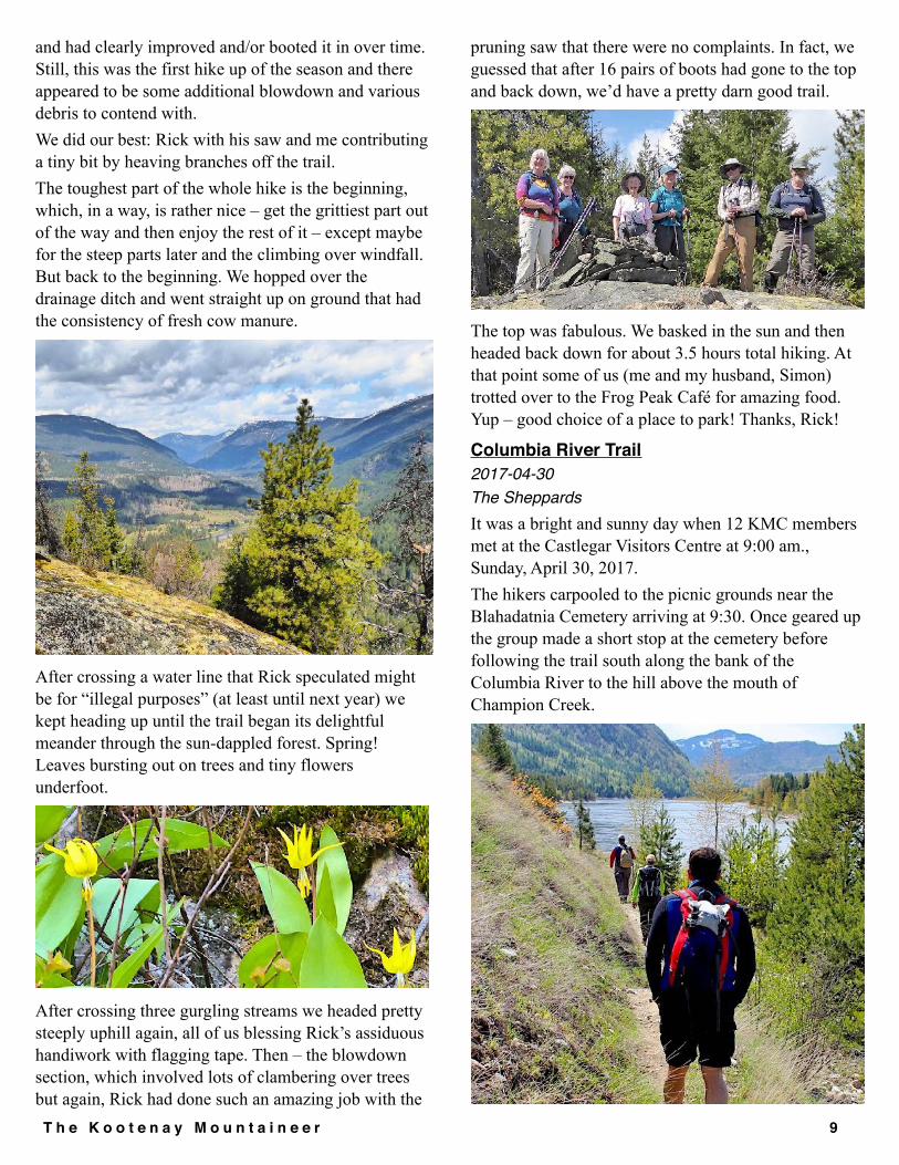
and had clearly improved and/or booted it in over time. Still, this was the first hike up of the season and there appeared to be some additional blowdown and various debris to contend with. We did our best: Rick with his saw and me contributing a tiny bit by heaving branches off the trail. The toughest part of the whole hike is the beginning, which, in a way, is rather nice – get the grittiest part out of the way and then enjoy the rest of it – except maybe for the steep parts later and the climbing over windfall. But back to the beginning. We hopped over the drainage ditch and went straight up on ground that had the consistency of fresh cow manure.
After crossing a water line that Rick speculated might be for “illegal purposes” (at least until next year) we kept heading up until the trail began its delightful meander through the sun-dappled forest. Spring! Leaves bursting out on trees and tiny flowers underfoot.
After crossing three gurgling streams we headed pretty steeply uphill again, all of us blessing Rick’s assiduous handiwork with flagging tape. Then – the blowdown section, which involved lots of clambering over trees but again, Rick had done such an amazing job with the
pruning saw that there were no complaints. In fact, we guessed that after 16 pairs of boots had gone to the top and back down, we’d have a pretty darn good trail.
The top was fabulous. We basked in the sun and then headed back down for about 3.5 hours total hiking. At that point some of us (me and my husband, Simon) trotted over to the Frog Peak Café for amazing food. Yup – good choice of a place to park! Thanks, Rick!
Columbia River Trail2017-04-30The SheppardsIt was a bright and sunny day when 12 KMC members met at the Castlegar Visitors Centre at 9:00 am., Sunday, April 30, 2017. The hikers carpooled to the picnic grounds near the Blahadatnia Cemetery arriving at 9:30. Once geared up the group made a short stop at the cemetery before following the trail south along the bank of the Columbia River to the hill above the mouth of Champion Creek.
T h e K o o t e n a y M o u n t a i n e e r �9

From here the hikers followed the trail above the north side of the creek and joined a segment of the Trans Canada Trail that runs from the City of Trail to Castlegar. At 10:15 am the crew crossed Champion Creek and proceeded South over Jordan Creek and seventeen freshly dug channels waiting for culverts. (Installed by May 14th.)
At 11:20 am. the hikers stopped for a snack just south of the newly refurbished navigation markers. A blue heron and a pair of Canada geese were spotted on the river. After a snack the crew continued to a point opposite Sullivan Creek for a lunch break. It was a wonderful spring day for relaxing by the River.
By 12:20 pm. the hikers were back on the trail passing the mouth of Murphy Creek by 2:00 pm. and arriving at the pre-parked shuttle vehicles by 3:10 pm. Hikers carpooled to Castlegar and drivers picked up their vehicles at the starting point of the hike. Everyone was on their way home by 4:00 pm. High temperature was 23 degrees C. Distance hiked was 16 km. Wildlife spotted was Canada geese, blue heron, tree swallows, a garter snake, grouse, golden eye ducks, and numerous deer ticks. Flowers spotted
included trilliums, glacier lilies, and Oregon grape. Other trail users included 4 female trail runners with a dog, one female mountain biker, 2 hikers with a dog, and 4 dirt bike riders.
KMC Member Hikers included: Steve Miller, Gail Williams, Jill Watson, Ted Ibrahim, Keith Watson, Sherry Watson, Jim Campbell, Cindy Campbell,
Caroline Shimek, P’nina Shames, and co-coordinators, Pat & Alan Sheppard.
T h e K o o t e n a y M o u n t a i n e e r �1 0

The Wapta Traverse – Bow to Stanley MitchellApril 23 to 28th 2017Although not a KMC trip, 10 of us including 7 KMC members, made a very successful traverse from Bow Lake to the ACC Stanley Mitchell hut and then out to the TransCanada highway at Field. All of us had done the ‘conventional’ Wapta traverse but we wanted to take in the new ACC Richard Guy hut which opened last year. This hut makes the route to Stanley Mitchell more attractive, taking us into some new territory. Here’s what the ACC website says… “The classic Wapta Traverse runs roughly north-south across the expanse of the Wapta and Waputik Icefields passing by four ACC huts. The east-west crossing, from Bow Lake to Takkakaw Falls and the #1 Highway near Field, BC is a classic traverse in its own right, but a much more serious one due to the 20-km crossing between the Bow and Stanley Mitchell huts. The new Louise and Richard Guy Hut at Mont des Poilus breaks up this crossing, making the trip safer and more comfortable and accessible.” Our initial plan was to spend one night at the ACC Bow hut and the on to the Balfour hut. This choice was dictated by hut availability. However, when at the Bow hut we realised there had been a lot of cancellations because of avalanche conditions, so a sat phone call to the ACC allowed us to change our plans and spend two nights at the Bow Hut and climb a peak. The weather forecast was mixed, but we were fortunate to have good weather for the traverse. The ski into the Bow hut was uneventful but we saw the tracks of an avalanche reported a few days earlier on the ACC newsnet. We were baked by the sun climbing the bowl to the hut.
Bowl below the Bow Hut
The next day, we made an enjoyable ascent of Mount Gordon and had an enjoyable ski back to the hut on good snow. This wasn’t enough for some of the group who did some more runs while the rest of us relaxed at the hut.
En-route to Mt Gordon below Mt St NicholasWe made the traverse to the Guy hut in favourable weather with some occasional poor visibility earlier in the day. A map with photographs provided by Parks Canada in the huts and on the ACC website showed how to find the drop-in point from the ridge above the Guy hut.
The new Richard and Louise Guy hutAfter we had settled into this beautiful new hut, half the group climbed nearby Yoho Peak. The new hut is a great facility with propane, solar and wind power. There is electric lighting and electric powered fan system upstairs and in a drying room. Propane is used for heaters and cooking facilities. The electric system can be managed remotely from the
T h e K o o t e n a y M o u n t a i n e e r �1 1

ACC office in Canmore. The only problem we had was with CO detectors that repeatedly went off in spite of having windows fully open. This was driving us crazy until we devised a” temporary solution” to the problem. Next morning we had an enjoyable descent to the des Poilus glacier on firm snow and then climbed up to the Isolated col. This could be tricky in high avalanche conditions as part of the route is in a terrain trap threatened by the slopes and cornices on Isolated peak. We were fortunate to do this when conditions were stable. From the col we descended to the Stanley Mitchell hut.
En route to the Isolated ColWe had two nights booked at this hut and the next day 4 of the group headed for Mount McArthur and 6 of us headed for Kiwetinok Pass with a possible objective of Mt Kerr. Both groups arrived back at the hut early afternoon having been turned around by cloud and whiteout conditions. The McArthur group got within a hundred metres of their objective before retreating. Frustratingly, the weather cleared up and it was sunny after we got back. The afternoon entertainment was crevasse rescue refresher practiced by a few folks … inside the hut to the enjoyment of the spectators. Next day we skied out, down the headwall in steadily deteriorating snow, to the valley bottom, then on to Takkakaw falls and the long, seemingly endless, road out to the highway. We were on snow except for the last couple of km which had to be walked.
The long road out!A most enjoyable trip was had by Paul Allen, Scott Allen, Teresa Allen, Bert Port, Andrew Port, Elena Cigala Fulgosi, Delia Roberts, Robert Herbst, Fred
Thiessen and Ken Holmes. Many thanks to Paul for his great trip organisation.
Submitted by: Ken Holmes
Dove Hill/Brilliant Overlook 2017-05-13Goody NiosiOn Saturday May 13 fifteen KMC hikers decided to do something brilliant (excuse me if this pun has been used ten gazillion times) and do the classic Dove Hill/Brilliant Overlook trek.
In all honesty, it really was quite brilliant. For a newcomer to the area in the throes of first discoveries, this one was a gem. We started at the golf course after Cindy Kozak-Campbell (trip leader extraordinaire) organized us. The flat walk to the bottom of Dove Hill was a nice warm-up before the gentle switchbacks leading to the top. Despite warnings of rain, the sun decided to allow dark looming clouds to hover all
T h e K o o t e n a y M o u n t a i n e e r �1 2

around us while shining down on the exact spots we walked all day long. Someone must have been doing something right – certainly not me. Our timing was perfect for the wildflowers. We saw Oregon grape, clematis, larkspur, paintbrush, wild parsnip, shooting stars, glacier lilies, orchids - and that was just a start. After a brief snack break on top of Dove Hill we descended to the power station and followed the trail to the bottom of Brilliant Overlook. This was a bit steeper but still pleasant – until we got to the boulder field. I believe Cindy had noted in her email that we’d be going through a rock field (it was boulders) and that it would be blessedly short (it went on for miles and miles and miles – okay – maybe just a few yards). I sank to the bottom of the pack, mentioning to anyone within earshot that I hate boulder fields. I believe I may have repeated myself several (a hundred) times. When Cindy said that we’d be coming back a different way, she became my all-time hiking hero.
And so we made our way to the top where we basked in sunshine and enjoyed a gorgeous valley view with distant rain clouds that didn't dare come anywhere near us. Our descent took us past the communication towers behind Brilliant Overlook and along a series of trails with a bit of road walking until we made it back to the
golf course. In the interests of finding this trail again – because who doesn’t love a loop hike – Helen recorded it on her GPS. I said pshaw to such hi-tech toys and dropped breadcrumbs along the way. Pretty sure that should work. Not meaning to gush, but I just have can’t help myself: great group and one of the finest trip leaders I’ve come across in all my years of hiking. Really! With stops, we hiked about five hours gaining (and losing) about 500 metres of elevation. All in brilliant(!) sunshine of course.
T h e K o o t e n a y M o u n t a i n e e r �1 3
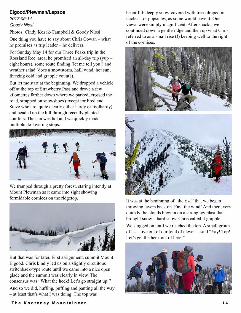
Elgood/Plewman/Lepsoe2017-05-14Goody NiosiPhotos: Cindy Kozak-Campbell & Goody Niosi One thing you have to say about Chris Cowan – what he promises as trip leader – he delivers. For Sunday May 14 for our Three Peaks trip in the Rossland Rec. area, he promised an all-day trip (yup – eight hours), some route finding (let me tell you!) and weather salad (does a snowstorm, hail, wind, hot sun, freezing cold and grapple count?). But let me start at the beginning. We dropped a vehicle off at the top of Strawberry Pass and drove a few kilometres farther down where we parked, crossed the road, strapped on snowshoes (except for Fred and Steve who are, quite clearly either hardy or foolhardy) and headed up the hill through recently planted conifers. The sun was hot and we quickly made multiple de-layering stops.
We tramped through a pretty forest, staring intently at Mount Plewman as it came into sight showing formidable cornices on the ridgetop.
But that was for later. First assignment: summit Mount Elgood. Chris kindly led us on a slightly circuitous switchback-type route until we came into a nice open glade and the summit was clearly in view. The consensus was “What the heck! Let’s go straight up!” And so we did, huffing, puffing and panting all the way – at least that’s what I was doing. The top was
beautiful: deeply snow-covered with trees draped in icicles – or popsicles, as some would have it. Our views were simply magnificent. After snacks, we continued down a gentle ridge and then up what Chris referred to as a small rise (!) keeping well to the right of the cornices.
It was at the beginning of “the rise” that we began throwing layers back on. First the wind! And then, very quickly the clouds blew in on a strong icy blast that brought snow – hard snow. Chris called it grapple. We slogged on until we reached the top. A small group of us – five out of our total of eleven – said “Yay! Top! Let’s get the heck out of here!”
T h e K o o t e n a y M o u n t a i n e e r �1 4

And so we dashed down to a sheltered spot for lunch. The other brave souls stayed on top to lounge around in the refreshing breeze. Chris noted that it was the long-time KMCers who enjoyed the summit while the “wimps” scurried back down. Proud to be a wimp!
On full stomachs we trudged back up to the top of Elgood and then, taking a cue from a thunderclap, crossed to Mount Lepsoe just below the ridgeline. Yeah – we also had thunder. Why not? By now the snow was almost creating a whiteout, although that might be a slight exaggeration. Mount Lepsoe was beautiful. Chris led us along the ridge – a bit farther than he should have he admitted – but it was such a lovely walk. Then down to the Seven Summits Trail. This was, shall we say, a bushwhack.
With frequent checks of his GPS, Chris got us there. Yay! Now it was all a simple hike back to the Strawberry Pass parking lot – or so we thought. We shortcut the trail here and there and then took the road down and then back up and then there we were in the woods in front of the creek with no bridge in sight. So we slogged our way along the creek until finally – ta-da! The bridge! Only problem was that it had a ridgeline of high frozen snow running its entire length. Getting across would have been pretty dicey had Steve not unpacked his shovel and started working away at it, sending huge bergs of ice into the creek. Obviously, Steve was the hero of the day. Oh – and Chris of course – he got us back as promised and we didn't lose a single body along the way.
T h e K o o t e n a y M o u n t a i n e e r �1 5

Slocan Rail TrailMarilyn Miller2017-05-21Seven KMC members cycled on May 21 from Passmore on the back road to Perry's , then looped down on the Slocan Valley Rail Trail. A beautiful, warm and sunny day, as seen in the pic.
Marilyn Miller (leader), Al and Pat Sheppard, Nanci Subaan, Richard Epton, Peter Martyn, Pnina Shames.
Lemon Fire Lookout Hike2017-5-23Eleven KMC-ers and one guest visited the former fire lookout on the North side of Lemon Creek. We drove 3.6 km up the Ponderosa FSR then hiked a short trail that linked to the lookout access road, then followed the 18% grade to the lookout.
The lookout is no longer active but is currently open to the public and provides great views in all directions including popular KMC destinations such as Mounts Gimli, Hoover, Grohman, the Palisades and the Slocan Valley North to New Denver Glacier and South to Passmore. The lookout register shows regular visitors arriving on foot, ATVs, 4WDs and horses. KMC-ers were the first visitors of this season due to snow on the last km of the road. The lookout was operated as a tourist destination for a time under the name Skycastle but the business appears to be dormant. The tower also supports equipment which provides internet and other communication services to the mid Slocan Valley. A patch of snowfree meadow provided a nice lunch spot where we could spread out and enjoy the views. While the hike is on a road it is more like a trail than a logging road as well as much steeper. It is a good shoulder season hike with some shelter at the top if weather is poor. Summary Stats: 4 km one way with about 700 m of elevation gain. Thanks to Sheila Sinkie, Goody Niosi and Ann Meidinger for joining me on the pre-hike to check out snow levels.
We were Chris Cowan, Frank Fodor, Betty Carlson, Leo Jansma, Roberta Sokolawski, Gayle Buchner, Ross Bates, Max Karpinski, Brad Howard, Richard
Epton and a guest from France, Camille Guy.Rick Mazzocchi, Trip Coordinator.
T h e K o o t e n a y M o u n t a i n e e r �1 6

Mt Brennan2017-05-28Peter JordanThis spring we have been lucky to have a near-record deep snowpack and a late spring, so the skiing up high has been good through May and well into June. Although residents of low-lying areas in the Slocan Valley are probably wishing the snow was all gone. Our group of about 10 interested people had shrunk to four by Saturday - maybe people were put off by the early start? Hot weather and wet-snow avalanche hazard in the afternoon made a dawn start necessary. We camped at the trailhead on the Rossiter Creek road on Saturday night. (This is now the trailhead for the Lyle Creek - Mt Brennan trail, since the old bridge over Whitewater Creek is gone. Follow the Rossiter-Lyle Forest Service Road, 4 km SE of Retallack, to 7 km where you will see the trail sign.) We started hiking up the trail just after 5 AM. It’s mostly an old mining road, which leads to the old trailhead below the mine. Here we put on our ski boots, and carried our skis up the partly snow-covered trail to the mine waste pile. Here we started skiing, up the steep slope covered with old avalanche debris, to Lyle Lakes. It had frozen only slightly overnight, so the snow was firm but not icy-hard. The “fast runners” Elena and Fred then took off for the summit, arriving at about 9:40, and we were all there by a little after 10:00. The weather was clear and windless, T-shirt conditions all the way up. Skiing down, the snow conditions were very good almost to Lyle Lakes, and mushy below that. We were down by noon. The new trailhead is at 1330 m, and the old trailhead is about 1400 m. The mine, where the skiable snow started, is at 1650 m, and the summit is 2902 m.
We were: Fred Thiessen, Elena Cigala-Fulgosi, Tyler Gale, and Peter Jordan.
Photo: At Lyle Lakes (Peter Jordan)
Davis Creek Trail2017-06-07Goody NiosiMy first gig leading a hike for KMC. Was it a success? Well, we started with 10 people and came back with 10 almost five hours after setting out. I’d call that a success. Yes, I am aware that my standards are low but hey – it’s a start!
I chose to bring people to the Davis Creek trail about fifteen minutes north of Kalso not so much for the views (pretty darn fine) or even the heart-thumping elevation gain (600 metres in one hour) but for what lay 45 minutes along the ridge: old cedars that are as fine as any I have ever seen, especially a grove of five magnificent elders hugging each other in a semi-circle – like a giant amphitheatre. These trees inspire awe in even the most jaded heart.
T h e K o o t e n a y M o u n t a i n e e r �1 7

We continued past the old trees to Fishhook Lake at the end of the trail, swatted madly at mosquitoes for a few minutes, took the requisite photos and hiked back to the lookout for a late lunch.
And then, of course, the knee-pounding descent to the cars. Thanks to a small handful of volunteers in Lardeau, the Davis Creek Trail is beautifully groomed and easy to follow. In a word or two – a pleasure to hike.
Participants: Janis Gilbert, Caroline Shimek, Richard Epton, Andrea Vowell, Krista Bourke, Gayle Bouchner, Andre Piver, Max Karpinski, Jan Osborne, Goody Niosi
Buchanan Access2017-06-10Goody NiosiSomeone up there loves Sheila Sinkie! Who else could schedule a hike in the middle of a rainy, cloudy, cold spell (June 10), and manage to carry the entire thing off without a drop of moisture falling on us? On top of that, we even had sporadic sunshine! That in itself was enough to make the Saturday hike a success – but there were other factors too. One: a rather brilliant and motley mix of KMC folks who found something to love every step of the way. (really – KMC people are just the best!)
Second: a varying topography, which never ceased to engage us. The Buchanan Access trail is a point-to-point hike that is either 10 or 12 kilometres long depending on whose track you are reading; and though it doesn’t feature any sort of spectacular high point with a 360 view, it offers so much else. We started just north of Kaslo and after a brief dip, the well-groomed trail rose steadily up for about an hour or more on fine switchbacks and the occasional non-switchback (to keep us on our toes – mustn’t get too complacent). As we rose up we had increasingly fine views of Kaslo below us and Kootenay Lake stretching off to the south, as well as cloud- wreathed mountains across the lake.
T h e K o o t e n a y M o u n t a i n e e r �1 8

We wandered through varying stands of trees, some hung with lichen, others sporting interesting fungi or showing off their woodpecker holes. We had tons of wildflowers and, my favourite bit, a riparian area with bridges over the wet bits and loads of moss in iridescent green.
After a series of long switchbacks to the high point of the trail, we headed down on a gentle slope, had lunch and ended up at the Wagon Road and the Cross-Country Ski Area. After a bit of creative car shuffling, we were done for the day. As shoulder season hikes go, I declare this one a winner. Heck yes! I’ve already done it three times this season! Do you really need any further proof that it's terrific?
On our trip were Allison Sutherland, Andrea Vowell, Cindy Kozak-Campbell, Goody Niosi, Jane Power, Laurie Heyler, Richard Epton, Shelley Richards and
Sheila Sinkie.
T h e K o o t e n a y M o u n t a i n e e r �1 9

Granite Mountain2017-06-17Jayme MoyeMy first outing with KMC was the Granite Mountain hike at Red Mountain Resort on June 17, 2017. I’m a new member who moved to Nelson 2.5 weeks prior, and had enough boxes unpacked that I felt I’d earned some quality time in the outdoors. Plus, it was a perfect summer day with marshmallow clouds, a bluebird sky, and no rain. Jocelyn LaFace, who grew up in Rossland and knows the resort like the back of her hand, led the hike. I was impressed that all nine participants not only arrived on time, but several minutes early. And I was surprised to find that I wasn’t the only American in the group. There were two others: Peter who’d also recently moved to Nelson, and Tom who was visiting from Hawaii. This punctual, international group of mountaineers commenced trekking at 8:36 a.m. Jocelyn and Cindy Kozak-Campbell were both wearing hiking shorts with gaiters, which I soon realized wasn’t a quirky Canadian fashion trend. It was because we were often off-trail, walking through scratchy underbrush. The bushwhacking felt particularly adventuresome to me—in Colorado, where I’d been living for the past 18 years, there’s always a trail. There’s also always other people on said trail. Apart from two guys walking dogs on the service road leading out of the parking lot, there was no one else on the trail, or non-trail as it were. I was thrilled to be having a true wilderness experience.
The start of the hike at the base of Granite MountainWhen we began following a swath of single-track straight up beneath the Motherlode chairlift, I made another astute observation about the difference between hiking at a resort in British Columbia versus Colorado.
Jocelyn, Tom, Jayme, Jeff, and Betty
Bushwhacking up Southern Comfort on Granite Mountain
“There are no switchbacks!” I said out loud. The group paused. “Switchbacks?” said Jocelyn. “You know, the paths that zig-zag up the mountain in a more, err, civilized, manner,” I said. “Oh, we have those,” said Jocelyn. “They’re for mountain bikers.” I couldn’t help but smile. “So, this is how it’s done in Canada, eh? Straight up.” The group assured me that yes, this is exactly how it’s done in Canada. And everyone had a good chuckle.
T h e K o o t e n a y M o u n t a i n e e r �2 0

Cindy and Tom negotiating Southern Comfort on Granite Mountain
Despite going straight up for much of the time, my legs (and lungs) appreciated the fact that the elevation is less here; the peaks we were negotiating were about half as high as in Colorado. The crux of the ascent was near the end, when we went straight up a blue run named Southern Comfort. I was one of the first ones up, along with Peter. I attributed my speed to the fact that my body was primed for much higher elevation. Later in the hike, when Peter and I encountered fresh bear scat, I understood that our being in the lead had nothing to do with my fitness level at high altitude, and everything to do with KMC’s practice of using Americans as bear bait.
Jayme enjoys the view from the top of the Southern Comfort run on Granite Mountain
At the top of Southern Comfort, we regrouped and collectively took in the view of Red Mountain against the backdrop of seemingly endless peaks stretching deep into the state of Washington. Jocelyn told me this area of the resort was known as Paradise. I couldn't argue that.
Cindy, Jill, and Tom traverse the ridgeline en route to the summit of Granite Mountain
We finished the ascent with a brief traverse across a ridgeline followed by a short, but satisfying section of scrambling. At the 6,800-foot summit, we enjoyed packed lunches and 360-degree mountain views. Total ascent time was about 3 hours.
The group takes on the scramble to the summit of Granite Mountain
T h e K o o t e n a y M o u n t a i n e e r �2 1

Down hiking the snow-covered Main Run on Granite Mountain
We took a different route down, glissading on the still snow-covered Main Run, and then bushwhacking our way back down to the service road (apparently, you go straight down in Canada as well as straight up). We were treated to non-stop panoramic mountain vistas the entire descent, including a lovely, birds-eye view of the town of Trail, and several gushing waterfalls.
Peter stops to admire a waterfall while descending Granite Mountain
Total descent time was about 1.5 hours. I think I’m going to like it here. The crew: Me (Jayme Moye), Jocelyn LaFace, Cindy
Kozak-Campbell, Peter Berkey, Tom from Hawaii, Jill Watson, Betty Carlson, Andre, and Jeff.
T h e K o o t e n a y M o u n t a i n e e r �2 2

Lost Mountain Trail Update
from Chris, Trails & Access Director.We’ve been working with Lisa Tedesco of Salmo Valley Trails, who has been instrumental in obtaining grants, some of which will be used to upgrade our access to the Lost Mountain Summit Ridge near Kootenay Pass. We continue to work on getting the route for the trail up to the treeline re-established. Our original route started from a chain up area about 10 km west of Kootenay Pass, but when we applied for permission to refurbish the trail, BC Highways Dept didn’t like the trail head location. We were approved for another location, at the avalanche gate about 1.6 km distant, to the west.
On May 10 A party of 5 of us scoped out the new route which went steeply up the hill for about a half KM and then paralleled the highway along a bench to meet the old route above the original proposed trailhead. Given previous experience with bushwhacking in this area, we were prepared for some nightmare blowdowns and bush, but the route proved to be quite easily navigable for the most part, and avoided a big blowdown on the beginning of our previous route. We flagged the area for the Trail Construction crew and did some basic brush clearing, and enjoyed one of the first days of real summer weather in the process. Many thanks to participants Bruce Reader, Fred Richer, Petra Hekkenberg, & Brad Howard. The only casualty was one of the KMC Loppers and we didn’t even get too many scratches.
On June 4 we had another hike, this time all the way to the summit via the new route. We did a little bit of snipping, put in some more flagging on the upper part of the trail, and removed some misleading flagging from our earlier attempts to find a route in the last couple of years. It can be especially confusing on the descent, just below treeline, when a trail leads down to the left into the “valley of doom”, a dreadful place full of devils club, epic blowdowns and a slippery rock ravine, once visited, and vowing never to return.
One must stay to the right at this point and go down the ridge to the east. This is a nice partially open area with a good gentle slope to it, but there is a lot of beetle kill deadfall which has to be dealt with, currently adding a lot of exertion to the hike. Some diamonds remain near treeline from the original trail, but many of the trees have fallen in the past couple of years. We found patchy snow near treeline, and mostly snow cover a metre or more above 2000 metres, but a bit treacherous for much boot skiing on the way down due to some soft areas near trees and hidden rock bluffs. Hot weather is making the snow pack diminish fairly quickly. It was a warm and muggy day. A breeze up high was a welcome relief from the blackflies and
T h e K o o t e n a y M o u n t a i n e e r �2 3
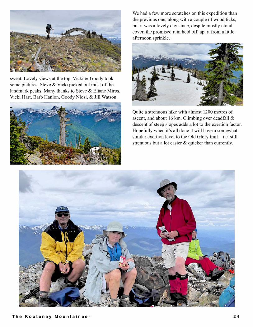
sweat. Lovely views at the top. Vicki & Goody took some pictures. Steve & Vicki picked out must of the landmark peaks. Many thanks to Steve & Eliane Miros, Vicki Hart, Barb Hanlon, Goody Niosi, & Jill Watson.
We had a few more scratches on this expedition than the previous one, along with a couple of wood ticks, but it was a lovely day since, despite mostly cloud cover, the promised rain held off, apart from a little afternoon sprinkle.
Quite a strenuous hike with almost 1200 metres of ascent, and about 16 km. Climbing over deadfall & descent of steep slopes adds a lot to the exertion factor. Hopefully when it’s all done it will have a somewhat similar exertion level to the Old Glory trail – i.e. still strenuous but a lot easier & quicker than currently.
T h e K o o t e n a y M o u n t a i n e e r �2 4

Some History of the Bonnington Huts
By George ApelIn the late 80s, after complaining on two successive winter trips to Huckleberry Hut, about the rotting lower logs on the backwall, Tom Bell and myself decided that someone should do something about it, and after reflection, that someone was us. Almost twenty years after the Kootenay Section of the ACC, had done improvements, in the fall of 1985, Tom and I began gathering fire killed cedar snags and skidding them up the road with my 2wheel drive Datsun pickup. Tom’s father, Jack Bell got curious about what we were doing and came up for a look. At that point, everything changed. Jack taught us how to use a broad ax, brought in more logs from his property and identified the direction for reconstruction. We rolled the top off the building and starting from scratch with the base logs and new walls and afterward we rolled the roof back on. That winter, Bill Bing and Ira Schwartz used the Nelson Nordic’s Snowmobile to take in the final touch, the hand made cedar door built by Jack Bell (hence the bell engraving on the door.) Several years latter, I went back with another crew and we chinked the walls and upgraded the roof sheathing with 2x4 cedar, and then the roof itself. This project encouraged me to take on another. After skiing into Kokanee, a couple times, I was left with the feeling there should be someplace to ski that didn’t cost nor require reservations (how naïve). Having skied at Grassy multiple times, tenting or snow caving, I thought it would be nice if there was a cabin there as well.
In fact, I thought that a hut to hut tour would be interesting. In 1986, I went to the Forest Service with the idea and approached the KMC. Fred Thiessen, then
the Regional Forest Service Recreation Officer, and I skied a portion of the Bonnington traverse and looked at possible routes and locations. I applied for and received a grant from the federal government, sponsored by the KMC, to employ four individuals on unemployment insurance, to build the remote cabins. Work started in May, with an old KMC hiking camp wall tent and other camp gear flown in, with time donated, by Highland Heliocopters. The crew backpacked into the Grassy site on snowshoes and began work. Initially we had to dig down through five feet of snow to put in the footings. During this time fallout from Chernobyl occurred, our camp was raided by bears and the “B Fire” on the Bombi occurred. This fire was somewhat a blessing as a helicopter assigned to the fire was used to bring in the shakes for the roof, and fly out most of the camp and equipment. But the structure was completed, perhaps a little slower than anticipated, but all work was done by hand, the only power tool was a chain saw. The logs were all moved using hand tools and four men carrying them. All lumber was milled on site. From Grassy, work then proceeded to Copper Mountain in that same year. Copper Mountain had the advantage that the camp could be driven to, after the road was cleared of snow in places.
Work was begun in July. The time for milling all the logs at Grassy took too long, so I determined to make Copper in more of the traditional style. The immediate site was chosen based on the trees available, the view, and shelter. Again we fell trees, carried the logs to the site, and began to build. We were interrupted only by an unseasonable snowstorm that dropped four inches on us, forcing us to walk out that weekend. Again, all work was done by man power. Think about that the next time you look at the sill logs on the bottom. The
T h e K o o t e n a y M o u n t a i n e e r �2 5

majority of the structure was completed that summer before funding ran out. Later a KMC work party cut in and installed the door, installed the cook stove, donated by the Forest Service, and put finishing touches on the porch. The following year, 1987, I ran another work crew funded by the provincial government. We chinked Huckleberry, Grassy and Copper Huts, and upgraded outhouse facilities, among other projects. Sometime after this, I became Huts and Trails coordinator for the club and for the next 6 years. Receiving an annual budget that I carefully managed, saved up for the final link in the Hut to Hut Tour. Originally the plan called for the Steed Hut to be built overlooking a small lake on the north side of the range. But due to negotiations with the residents of Glad in whose water shed the cabin would have been built, the location was changed to the south side of the Bonnington Range overlooking the headwaters of Erie Creek.
The actual site had originally been the location of a fire look out before the area had been devastated by a massive fire in the drainage. Remains of that look out are just outside the cabin, and the copper telephone line can still be found. The new design was based on the old ranger A frame at Kokanee Glacier, and drawn by the Macek Brothers. Most of the materials were donated or purchased well below cost. The material for the A frame supports came from Kalesnikoff Lumber, the 2x6 roof boards from Atco Lumber and Alden Bigsby did the custom re-milling for the tongue and groove. All the materials were pre-packaged in lots that could be carried by a Jet Ranger. Dave Fitchett, Range and Recreation Officer for the Arrow Forest District, provided considerable coordination assistance for Stead
hut and all the hut projects. Again, Highland Helicopters provided considerably more time, than was paid for, flying in loads from a landing on the Erie Creek side of the range. Work crews were organized by Eric White, and ran for most of the fall. A surprising amount of work was accomplished on the first long weekend, and proceeded through the fall until we had the roof on and could close up. That winter, a finish crew, made up of those that had put in the most time, were flown in, to finish installing the stove pipe, connecting the stove, and some other critical jobs. This volunteer work group had the pleasure of then skiing out. Subsequently other work after this season included moving and rebuilding the outhouse, as well as the continual issues of heating and fire wood for all the huts. Some of the goals behind the original idea were lost of course, but as a public resource, available for all, the Bonnington cabins remain a valuable resource, that would be hard pressed to replace.
Huckleberry Hutfrom the Spring 1968 Kootenay Karabiner
Grassy Hutfrom Volume 32, 1989 of the Kootenay Karabiner
T h e K o o t e n a y M o u n t a i n e e r �2 6

Bonnington-Steed Recreation Area
Interesting times and challenges for the Kootenay Mountaineering Club are presenting themselves on several fronts in the Bonnington Range. The Bonnington-Steed Recreation Area is becoming evermore busy. Winter is seeing increasing activity in the area mainly consisting of heli-skiing, snowmobiling, and ski touring. Summer time use includes hunting, hiking, dirt biking and ATV’ing. Mountain bike groups are looking at developing a bike-friendly Bonnington Traverse. The KMC maintains four huts in the Bonningtons that are booked by skiers primarily wanting to do the winter Bonnington Traverse. Hut bookings have steadily increased over the past ten years from under 500 bunks in 2008 to where 1,400 bunks have already been utilized to this point in 2017. Following are three areas involving the Bonnington Range that the KMC Exec has been exploring:
• Ongoing hut maintenance • Long term vision for the Huts (year 2050) • Bonnington-Steed Recreation Area – Winter
Management Plan
Ongoing Hut MaintenanceIt quickly became apparent after the departure of former Huts Director, Graham Jamin, that there was a serious lack of bench strength for ongoing hut maintenance. Exec looked at various options for maintenance of the four huts and came down to the following choices:
i) KMC continues to maintain the huts as per the current Agreement with the Province,
ii) KMC enters into a partnership with another agency (such as the Alpine Club of Canada), or
iii) KMC hangs the keys on the gate post and walks away from the Bonnington Huts. Since the Bonnington Huts are owned by the Province, it would then fall on the Province to come up with alternative maintenance arrangements.
Prior to making its decision, Exec undertook a survey to determine member interest in both using the huts and in maintaining the huts. It became apparent that only a very small number of the membership do the Bonnington Traverse. Somewhat more book the Grassy and Huckleberry huts at either end for one or two
nights to ski tour only in that vicinity. In some years, when logging operations keep Rover Creek FSR open, Copper hut is also often booked for local skiing. About a dozen members put their hands up to volunteer to do maintenance, of which a few had an interest in taking on leadership roles. Exec also had lengthy discussions with the ACC, who made it clear that obtaining the four huts was very much within ACC’s mandate and something their membership would strongly support. They offered to assume all hut maintenance responsibilities or enter into a partnership arrangement with KMC. Option iii), above, to walk away from the Huts was not seriously considered. Sandra Fuller, KMC VP, and I led efforts to prepare a recommendation to Exec on future KMC involvement in the Huts. We met twice with those KMC members who stepped forward to do hut maintenance, while we also entered into discussions with the ACC. Exec was kept informed on the results of the various discussions and meetings. While a partnership with the ACC was appealing, the fact that a group of KMC members had stepped forward to look after the huts swung Exec’s decision towards keeping Hut maintenance within the KMC and to continue its existing partnership Agreement with the Province (which runs to year 2023). From amongst those members who volunteered to contribute to the Huts maintenance, David Heyduck, agreed to be interim Cabins Director until the position comes up for renewal at the 2018 AGM. The KMC is fortunate to have someone as qualified and keen as David take on this task. As well, Exec is grateful to all those folks who volunteered to help out and ask the membership to assist them should the call go out. In making its decision to continue to have the KMC maintain the Bonnington Huts, Exec would not have approved this option if the entire load fell onto one person. It was clear that this would not be the case. On related matters, in order to cover the costs of the increasing huts use, increasing user expectations, and the fact that the fees have not changed for many years, Exec obtained Provincial approval to increase the booking fee from $10 to $15/bed/night, effective September 1, 2017. While the fees are intended for huts upkeep, the Province will allow the KMC to spend up to 30% of the fees collected, to be spent on other KMC items, pertaining to outdoor recreation, subject to the
T h e K o o t e n a y M o u n t a i n e e r �2 7

Province’s prior approval. This is another incentive for KMC’s continuing involvement in the Bonnington huts. As well, in appreciation for the years of dedicated service that Graham Jamin provided as Cabins Director, Exec voted to waive future Hut fees for Graham and his wife, Jude, in perpetuity.
Long Term Vision – Bonnington Huts to year 2050The first task for David Heyduck, and the hut volunteers, will be to assess the immediate needs for the huts and submit a budget to Executive. However, KMC as a whole, in partnership with the Province, has also been assigned a task, that being to develop a long term vision on what should be done to the Bonnington Huts to take them to year 2050. Consideration needs to be given to many aspects (ie. replace vs. upgrade, hut capacity, styling, type of heating and appliances, should KMC keep Huckleberry Hut?, etc.). The character of the traverse is changing. Commercial guides are marketing the Bonnington traverse to potential clients from far and wide. Kootenay residents now account for less than half the bookings and over 10% are from outside of Canada. The KMC and the Province need to address how the huts are to be managed (eg. commercial guides’ access, booking same hut for consecutive nights and blocking the traverse during prime traverse periods, special consideration given for KMC members’ bookings, etc.). If KMC members have constructive suggestions on the future of the Bonnington Huts, please communicate them to Executive. It is our intent to begin to prepare conceptual plans to take the huts to the year 2050.
Management Plan – Bonnington-Steed Recreation AreaA process was recently initiated by Recreation Sites and Trails BC to develop a management plan for the Bonnington-Steed Recreation Area. Members of Exec are meeting with other stakeholders (snowmobile clubs) and a facilitator, hired by the Province to assist the stakeholders in reaching a consensus on a management plan for the Rec Area. This process is focussing on winter use; no commercial stakeholders are involved at this stage. Discussions are in early-days. All participants at the table have been cordial and well-spoken. The main question is, should certain popular ski areas be designated as non-motorized and snowmobiles excluded from some of the prime ski terrain. This is a difficult question, as it’s recognized
that much of the Bonnington Range has traditionally been used by snowmobilers. Also, we realize that this is not wilderness - activities such as logging, mining, hunting, and commercial heli-skiing have long co-existed with back-country skiing and hiking. The KMC position is focusing on preserving popular ski areas as non-motorized or restricted motorized. Terrain around Grassy and Copper Huts has been identified for non-motorized ski touring. Other areas are also being considered, primarily in and around the eastern end of the Bonnington Traverse. We cannot say how this will turn out, but it has been encouraging so far. Exec will endeavour to keep KMC members informed as this process moves along. Doug ClarkPresident, KMC
Participate in the Kootenay Mountaineering Club’s 150 Summit Challenge
To commemorate Canada's 150th birthday, KMC Executive is challenging the club's membership to summit 150 different mountains. Members are encouraged to combine efforts to collectively climb 150 different Canadian mountains between May 1, 2017 and the end of 2017. All 'named' mountains in Canada are eligible to be climbed as part of the challenge. To qualify as one of the 150 summits of record, there must be at least one KMC member who reaches the summit. When you have summited a named Canadian mountain, you can log your summit from the link on the members only documents section of the web site. With the nice weather beginning and summer starting we would love to see the current list grow. Anyone who submits one of the 150 peaks will be entered into a draw for a $150 dollar gift certificate. However, your name will only be entered once, even if you have entered more than one summit onto the list. That being said, feel free to enter as many first summits as you are able. Jocelyn LaFace, Membership Director, is the arbiter and chief cheer leader for the challenge. If you have questions, she can be contacted by email at [email protected].
T h e K o o t e n a y M o u n t a i n e e r �2 8

Trip Report (editor’s fault)
Pend O’reille Loop Bike Ride2017-05-04Jill WatsonOriginally scheduled for the Friday, and believing the weather Gods, I fortuitously switched this outing to the day before, and they delivered with a sunny, warm, bluebird day that we hadn’t seen for so long. Four of us met at The Waneta Mall parking lot and were on our way alongside the Columbia River by 9.15 a.m. Too soon we were earning our keep with the rather long steep climb towards the Pend O’reille valley, and after a water break enjoyed the peace of the area as the road led us alongside this river towards the 7 Mile Dam. We passed the lower section of a recent slide which had delivered a few large trees at the roadside. Eventually we arrived at the dam which had 1 spillway open and the rooster tail at the bottom was awesome. We continued beyond the dam where the pavement gave way to loose unpaved surface on the old Pend O’reille to Nelway road. We dropped down to The Buckleys Campground, which was gated and not yet open for the season. Perfect. This is a very lovely spot and we enjoyed our leisurely lunch. Frank entertained us with a video of an encounter he had last year with a rather large all puffed up bull elk sporting massive antlers! We were all very impressed with Franks controlled desperate ”XYZs” towards this aggressive animal who obviously thought Frank a real threat to his nearby harem, as we could hear the cows having their say in the matter also. As they were each dodging to the left, to the right and so on, the only way out for our friend was to high tail it, which he did, video still rolling, and escape was looking good, until, he tripped over a log and splat. Fortunately for Frank, Mr. Elk was happy with the outcome and went on with his lady friends. We said farewell to the campground maintenance man and tackled the short but very steep climb back up to the upper road which took us back along the Pend O’reille valley and leads through lovely forest with great views. Due to our cool Spring, I only noticed a few clumps of Balsam Root and no blossoms on any shrubs. We had to dismount to negotiate around the upper end of a large washout and we agreed this section would likely not be repaired. Then on through farmland which was lush and green, then we quickly
ran a slalom course with a few cows that were wandering along our road. Finally, the long carefree ride down, through Columbia Gardens and back to some traffic as we arrived back at our vehicles at 1.30 P.M. A great 50 Km. ride. Thank you to my biker friends, signing off,
Jill and the Jocks, Bert, Steve and Frank.
T h e K o o t e n a y M o u n t a i n e e r �2 9