weather briefing mar26,2011
TRANSCRIPT
8/7/2019 Weather Briefing Mar26,2011
http://slidepdf.com/reader/full/weather-briefing-mar262011 1/4
Weather Briefing for Emergency Managers for March 26-27, 2011
National Weather Service
Tallahassee, FL
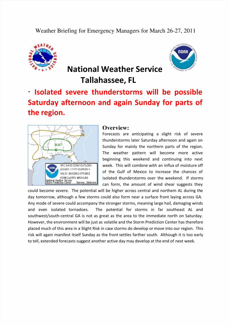
· Isolated severe thunderstorms will be possible
Saturday afternoon and again Sunday for parts of
the region.
Overview:
Forecasts are anticipating a slight risk of severe
thunderstorms later Saturday afternoon and again on
Sunday for mainly the northern parts of the region.
The weather pattern will become more active
beginning this weekend and continuing into next
week. This will combine with an influx of moisture off
of the Gulf of Mexico to increase the chances of isolated thunderstorms over the weekend. If storms
can form, the amount of wind shear suggests they
could become severe. The potential will be higher across central and northern AL during the
day tomorrow, although a few storms could also form near a surface front laying across GA.
Any mode of severe could accompany the stronger storms, meaning large hail, damaging winds
and even isolated tornadoes. The potential for storms in far southeast AL and
southwest/south-central GA is not as great as the area to the immediate north on Saturday.
However, the environment will be just as volatile and the Storm Prediction Center has therefore
placed much of this area in a Slight Risk in case storms do develop or move into our region. Thisrisk will again manifest itself Sunday as the front settles farther south. Although it is too early
to tell, extended forecasts suggest another active day may develop at the end of next week.
8/7/2019 Weather Briefing Mar26,2011
http://slidepdf.com/reader/full/weather-briefing-mar262011 2/4
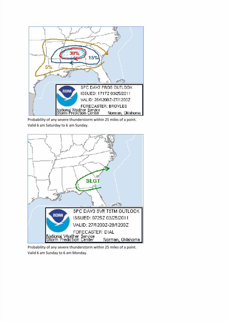
Probability of any severe thunderstorm within 25 miles of a point.
Valid 6 am Saturday to 6 am Sunday.
Probability of any severe thunderstorm within 25 miles of a point.
Valid 6 am Sunday to 6 am Monday.
8/7/2019 Weather Briefing Mar26,2011
http://slidepdf.com/reader/full/weather-briefing-mar262011 3/4
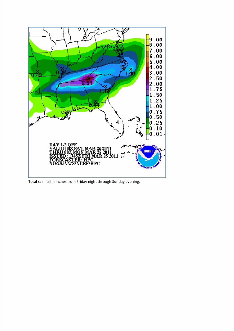
Total rain fall in inches from Friday night through Sunday evening.

8/7/2019 Weather Briefing Mar26,2011
http://slidepdf.com/reader/full/weather-briefing-mar262011 4/4
Weather Briefing for Emergency Managers for March 26-27, 2011
Summary:
** Showers and a few severe thunderstorms are expected to Saturday afternoon
and again Sunday afternoon along a slow moving surface front.
** The primary threats from these severe storms will be isolated large hail,
damaging winds and possibly.
** The potential for thunderstorms and possible severe thunderstorms will cover a
larger area on Sunday as the front settles farther south.
** Total rainfall from these storms will be fairly light as storms remain isolated
and fast moving.
** For additional threat information, visit our graphical hazardous weather outlook
at: http://www.srh.noaa.gov/tae/?n=ghwo_lightning
The National Weather Service in Tallahassee will continue to monitor this storm’s
progress. If you have any questions, please give our office a call at 850-942-8833
or on our toll free line at 800-598-4562 and ask to speak to a meteorologist. We areavailable 24 hours a day, 7 days a week. You can also reach us on our Southern
Linc phone at 1*77*284.