world meteorological organization - unfccc · world meteorological organization ... earthquake 8%...
TRANSCRIPT

World Meteorological OrganizationWorld Meteorological Organization
UNFCCC Technical Workshop under the UNFCCC Technical Workshop under the Nairobi Work ProgramNairobi Work Program
Integrating Climate Risk Management and DRR Integrating Climate Risk Management and DRR StrategiesStrategies
1010--12 March 200912 March 2009Havana, CubaHavana, Cuba
By By
Maryam Golnaraghi, Ph.D.Chief of Disaster Risk Reduction Programme

Agenda
• Hydro-meteo hazards and link to climate risk management
• How is WMO working strategically and operationally through its networks to assist its Members with the implementation of DRR and climate adaptation?– WMO DRR Programme (Since 2004)– WMO Initiative in support of climate adaptation
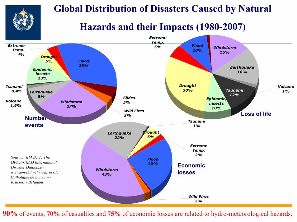
Global Distribution of Disasters Caused by Natural
Hazards and their Impacts (1980-2007)
Economic losses
Loss of lifeNumber ofevents
Volcano1,6%
Tsunami0,4%
Epidemic, insects13%
Wild Fires 3%
Windstorm 27%
Earthquake8%
Drought5%
Extreme Temp.
4%
Flood 33%
Slides 5%
Volcano1%Tsunami
12%Epidemic,
insects10%
Windstorm 15%
Earthquake16%
Drought30%
Extreme Temp.
5% Flood 10%
Tsunami1%
Wild Fires 2%
Windstorm 43%
Earthquake22%
Drought5%
Extreme Temp.
2%Flood 25%
Source: EM-DAT: The OFDA/CRED International Disaster Database -www.em-dat.net - UniversitéCatholique de Louvain -Brussels - Belgiumc
90% of events, 70% of casualties and 75% of economic losses are related to hydro-meteorological hazards.

Impact of climate on sectors are linked to….
• Changing patterns of hydro-meteorological extremes– Frequency, severity and location of droughts, floods,
tropical cyclones, heat waves, etc• Accumulation of risk linked to deviations of
meteorological and hydrological conditions from normal – Variations and changes in the onset of seasons,
warmer/colder than normal seasons, changes in the rainfall amounts and patters, etc.
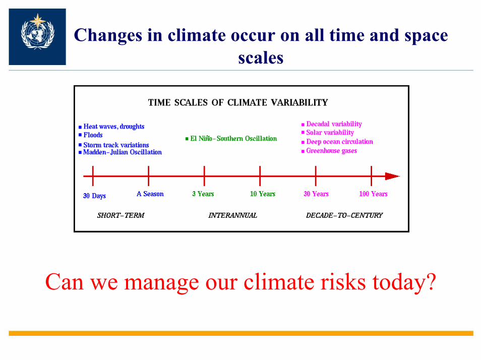
Changes in climate occur on all time and space scales
Can we manage our climate risks today?

Leveraging WMO networks to improve DRR and climate risk management at national level
WMO leverages global, regional, national cooperation with national development to ensure
development and availability of technical capacities at the national level.

PacificDecadal
Oscillation
NorthernAtlantic
Oscillation
UNFCCC negotiations
Research Side: 20 years of international coordination of scientific research and assessment
World Climate Research Programme (WCRP)World Weather Research Programme (WWRP)
Operational forecasting
systems
IPCC Assessments

WMO: Coordinates an Operational Global Coordination Network for Hazard Detection and Forecasting to Support
Multi-Hazard Early Warning Systems
Coordinated Satellite System
Global Data Processing and Forecasting System
National Meteorological
& Hydrological
Services
Global Observing System
Global Telecommunication System

WMO: Coordinates an Operational Global Coordination Network for Hazard Detection and Forecasting
Global Telecommunication SystemExchanges bulletins, forecasts, and other information
National Meteorological and Hydrological Services
National Meteorological & Hydrological Services developand disseminate authoritativewarnings for the country
Media Generalpublic
Privatesector
Government and civil defence
authorities

WMO Strategic Priorities in Context of comprehensive National Disaster Risk Management Framework
Underpinned by HFA
Risk TransferRisk Identification
Historical hazard data, analysis and changing hazard trends
Exposed assets & vulnerability
Risk quantification
PREPAREDNESS: early warning systems,emergency planning and response capacities
MITIGATION AND PREVENTION: Medium to long term sectoralplanning (e.g. building resilient infrastructure)
CAT insurance & bonds
Weather Risk Management
Other emerging products
Risk Reduction
Information and Knowledge SharingEducation and training
National Policies, planning and Legislation Organizational Coordination and Cooperation
21
3

National DRR Capacity Assessment Survey (2006)Mapping NMHSs’ Capacities, Gaps and Needs
139 out of 187 Countries responded
24/5254 %
25/3474 %
10/1283 %
18/2282 %
14/1974 %
44/4892 %
http://www.wmo.int/pages/prog/drr/natRegCap_en.html

National DRR Capacity Assessment Survey (2006)
CountryCategory
Planning & Legislation
InfrastructureObservationForecasting
Telecom.
TechnicalCooperation
&Capacities
Partnerships&
Concept of Operations
Percentage of countries
1 Need for development along all aspects-Guidance materials and best practices are also needed
12
2 Need for improvements along some aspects-Guidance materials and best practices are also needed
42
3 Self sufficient
- Need for improvements along some aspects- Guidance materials and best practices needed
26
4 Self sufficientGuidance materials and best practices needed
20
42 of the developing countries, of which 22 being LDC did not participate in the survey

1. Enabling Meteorlogical Services to provide data and analysis on
Meteorological, Hydrological and Climate Hazards
to Support Risk Assessment, Early Warning Systems, Sectoral Planning
and financial markets

Number of NMHS Keeping Hazard Data Archives and Status
0
20
40
60
80
100
120
140
Strong w
indsFlas
h flood
Thunderstorm
or lightning
Drought
River fl
ooding
Forest o
r wild
land fir
eEart
hquakes
Heat wav
e
Landsli
de or m
udslid
eHails
torm
Hazards to
aviatio
nDense
fog
Coastal fl
ooding
Tropical c
yclone
Heavy s
nowCold w
ave
Smoke, D
ust or H
azeStorm
surge
Waterborne h
azard
sTornad
o
Marine h
azards
Avalanch
e
Freezin
g rain
Airborne s
ubstance
sTsu
nami
Volcanic ev
ents
Desert l
ocust
swarm
Sandsto
rm
Data Archived Impacts data (loss of life + economic losses)
• Data archived are not standardised
• 90 % of countries indicated their need for guidelines and support in hazard analysis, mapping and statistics (WMO 2006 DRR survey)
TOP CONCERNS OF MEMBERS

Hazard data and informationNeed to initiate systematic projects…
To provide guidelines for standardization of Meteorological, Hydrological and climatic-related hazards:
1. Hazard data and metadata
2. Hazard analysis and mapping methodologies
3. Capacity development and training
4. Demonstration projects in selected countries

Guidelines for Hazard data and mapping
1. Floods (Flash Floods, Riverine Floods)
2. Droughts
3. Tropical Cyclone and Storm Surge
4. Other hazards (severe weather, heat waves, etc.)
5. Tools to assess evolution of hazard trends in the future …

IPCC 4th Assessment Report, 2007
(IPCC, 2007)
DroughtsProject with 10
African Countries to develop climate information (downscaling, etc.)(WMO/World Bank/ Link to UNDP CRM)
WMO Climate Adaptation Initiative
Need for production of local climate information

2. Development of Coordinated Early Warning Systems with Multi-
Hazard Approach
To support Protection of lives and livelihoods

Example 3: Cuba Cyclone Early Warning
ANALYSIS AND NUMERICAL
MODELS
DIFUSSION OF WARNINGS
RESPONSE ACTIONS
TV
RADIO
PHONE - FAX
INTERNET
GOVERNMENT, CIVIL DEFENSE,
RESIDENTS
Small country, 99% access to media (radio & TV), coordinated top-down warning and response mechanisms
WarningWarning

Example: Cyclone Preparedness Programme in Bangladesh

WMO Approach to Assist its Members in Strengthening Their Early Warning Systems
Identification of (more) Good
Practices
Documentation of Good Practices and
learning Lessons
Development of Guidelines for EWS
implementation based on Lessons Learnt
ProjectsNational Planning and coordination
Technical Capacity
Development
Implementation of end-to-end EWS
projects
Sharing of good practices
Building Capacities and
sharing experiences and lessons’ learnt

2nd Multi Hazard Early Warning SymposiumMay 5-7, 2009 (Toulouse, France)
1. Discuss four “good practices” in early warning systems presented by a team of national experts from the countries
France Vigilance system Shanghai Emergency Preparedness SystemBangladesh Cyclone Preparedness ProgrammeCuba tropical cyclone early warning system
2. Draft the First Guidelines on Multi-Hazard Early Warning Systems with Focus on Institutional Coordination and Cooperation”

3. Support of Weather Risk Management and Catastrophe
Insurance Markets

Role of National Meteorological and Hydrological Services in Financial Risk Transfer Markets
• Availability and accessibility of historical and real-time data
• Data quality assurance, filling data gaps, other value-added services
• Reliable, authoritative and timely data for contract design and settlement
• Forecasts for portfolio management and forward looking risk analysis
• Technical support and service delivery

Strategic partnerships to facilitate development at the national level
PartnersType Coordination
National / regional DRR
Implementation
Project Funding
World Bank(& GFDRR)
Development X X
ISDRCoordination X X
UNDP Development X X
OCHA, IFRC, UNICEF Humanitarian X X
FAO, WFP DevelopmentHumanitarian
X X
WHO Humanitarian X
European Commission Donor X
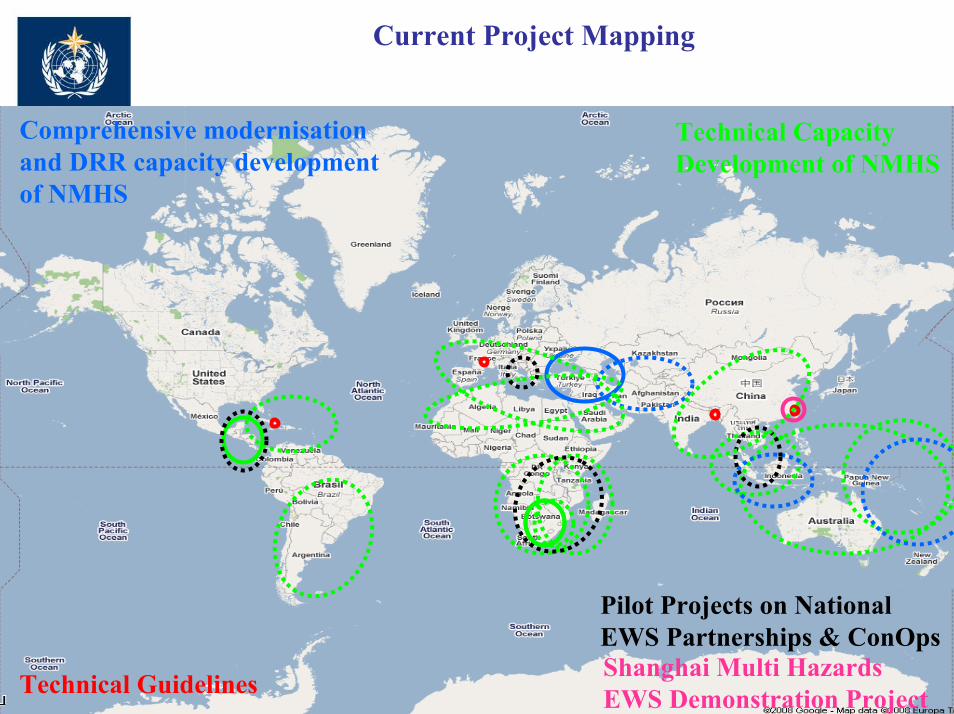
Current Project Mapping
Technical Capacity Development of NMHS
Comprehensive modernisation and DRR capacity development of NMHS
Pilot Projects on National EWS Partnerships & ConOps
Technical Guidelines Shanghai Multi Hazards EWS Demonstration Project
The Climate Information Challenge

WMO initiative to address the climate information challenge at the National Level….
Goal:– the development of science-based climate
information for climate risk management and adaptation to climate variability and change throughout the world to support poverty alleviation and sustainable development.

Global/Regional/National Cooperation Framework For Provisions of Climate Services
Four Major Thrusts:• Understanding of information needs of at-risk sectors
– Through partnerships (with UN, international and regional agencies)
• Coordinated network of global and regional climate centers to faciliate provision of tools and information to national centers– Building on what is there
• Further strengthen targeted climate research (WCRP, ICSU)
• Strengthen observation networks (with GCOSS; GEO and other partners)

World Climate Conference-3Better climate information for a better future
Geneva, Switzerland31 August–4 September
2009

Key Messages
• Need for a comprehensive risk managment approach
• Start with managing our climate risk today • Need for strong coordination and cooperation at
all levels to leverage knowledgs, expertise and resources (top down and bottom up)
• Need enabling environements and financial commitement to build and sustain capacities

Thank YouFor more information please contact:Maryam Golnaraghi, Ph.D.Chief of Disaster Risk ReductionProgrammeWorld Meteorological OrganizationTel. 41.22.730.8006Fax. 41.22.730.8023Email. [email protected]
http://www.wmo.int/disasters

Global/Regional/National Cooperation Framework For Provisions of Climate Services
feed
back
requ
irem
ents
inpu
t
feed
back
requ
irem
ents
inpu
t
Operational climate forecasting and analysis systems
Climate research,modelling and tools
Observations, monitoring, and data management
User Sectors(Improved decisions and policies)
Water resource Management
AgricultureTransportation
Disaster Risk Management
Health
Tourism
Energy
Urban infrastructure development
NGOsUN Agencies
Universities
Aid agencies
Media
Regional Development Institutions Private Sector
(Development and provision of climate services)Retrospective, real time and longer term, including seasonal to multi-decadal prediction
Science-based, and user-driven, based on requirement
User Interaction Mechanism
Network for Climate Services
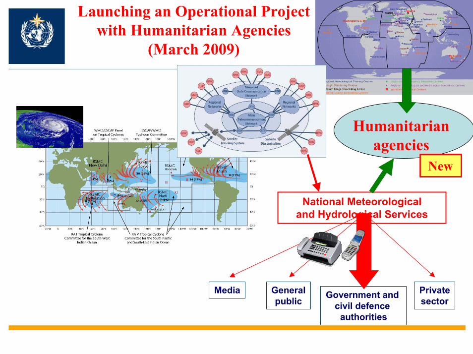
Launching an Operational Project with Humanitarian Agencies
(March 2009)
National Meteorological and Hydrological Services
Government and civil defence
authorities
Generalpublic
Privatesector
Humanitarian agencies
New
Media