alaska · dew distance early warning dmts delong mountain transportation system dnr department of...
TRANSCRIPT

March 2013
ALASKADEEP-DRAFT
ARCTICPORT SYSTEM STUDY

Alaska Deep-Draft Arctic Port System Study
Cover photo: Healy Arctic Cruise 2006Images courtesy USCG visual information gallery

a
FORWARD The Arctic is changing. Diminishing sea ice and expanded natural resource extraction are happening now. From drilling in the Chukchi Sea, dredging for gold in Nome, to ore and gas concentrate tankers coming over the top from Europe, Alaska is experiencing more and more traffic past its shores. Alaska’s western and northern coastline is mostly shallow with very little marine infrastructure. Coast Guard and other support vessels may be many days of ship travel away. Proper planning and responsible development is important to Alaska’s future. The State of Alaska and the U.S. Army Corps of Engineers partnered to study locations for an enhanced Alaska Deep-Draft Arctic Ports system. The Corps and the State established the foundation for this study in 2008 and 2010 and built on the good work of others such as the Northern Waters Task Force, the Arctic Marine Shipping Assessment, and workshops with the Institute of the North. This study could help guide deep-draft infrastructure development. This study presents opportunities for development of marine infrastructure in the Arctic by Federal, State, local and/or private sector.
Istockphoto.com

b Alaska Deep-Draft Arctic Port System Study
TABLE OF CONTENTS
PROJECT STUDY TEAM d
DEFINITIONS AND ACRONYMS e
EXECUTIVE SUMMARY 1
INTRODUCTION / PROJECT HISTORY 7
2008/2010 Alaska Regional Ports and Harbors Conferences 7
May 2011 Alaska Deep-Draft Arctic Ports Planning Charrette 8
Legislative Summary: State (budget) and Federal (authority/appropriation) 8
PROJECT SCOPE 9
Study Purpose 9
Study Scope 11
Arctic Context 12
Arctic Marine Traffic 12
STUDY AREA 15
Definitions of the Arctic 15
USACE/DOT&PF Arctic Ports Charrette – Arctic Descriptions 17
Alaska Deep-Draft Arctic Ports System Study Area 18
Potential Port Sites 19
Current DOT&PF Port & Harbor Projects 27
Current USACE Port & Harbor Projects 27
OTHER ARCTIC PORT PLANNING STUDIES 29
Northern Waters Task Force Report, Jan 2012 29
2009 Arctic Marine Shipping Assessment Report 30
Resource List of Current Arctic Studies/Projects 30
Bibliography of Arctic Research 30
PORT SITE EVALUATION 31
Multi-Criteria Decision Analysis Tool 31
Evaluation Criteria 32
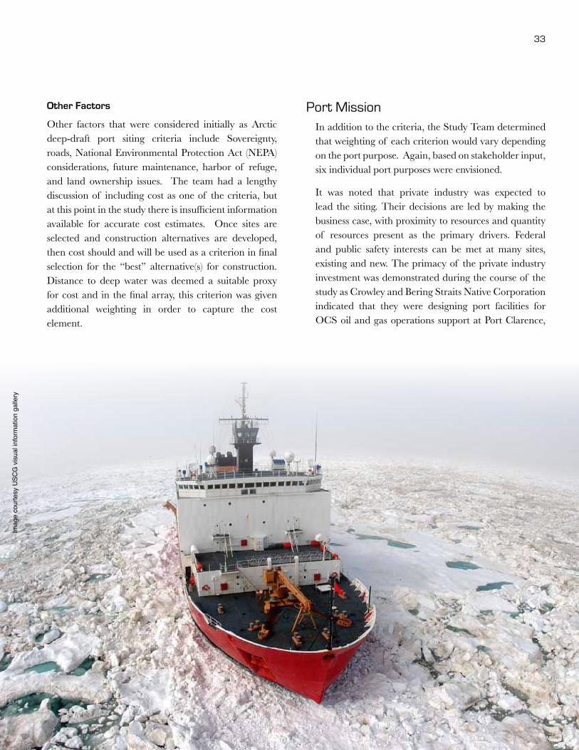
Port Mission 33
Port Site Technical Analysis 34
Investment Context 34
Private Investment 34
Port Site Short List 35

c
Community Investment 35
State Bond FY2013 36
Evaluation Summary Matrix 37
SCENARIO ANALYSIS 39
Scenario Development Process 39
Scenario Diagrams 40
Scenario Matrix 41
Ramifications of Alternative Scenarios 43
STAKEHOLDER AND PUBLIC ENGAGEMENT 45
USACE/DOT&PF Stakeholder Engagement 2008-2011 45
Other Recent Outreach Efforts 47
Arctic Meetings 2012 47
Stakeholder Interviews and Outreach 47
Project Websites (USACE and DOT&PF) 47
Review by Affected Stakeholders and the Public 48
PUBLIC/PRIVATE PARTNERSHIP AND PORT AUTHORITIES 49
P3 Defined 50
Benefits of P3s 51
Drawbacks/Risks of P3s 52
Successful P3 Creation 52
Port P3 Structures 54
Alaska P3 Projects 56
P3 Private Partners 59
Roadmap for P3 Generation 59
RECOMMENDATIONS 63
NEXT STEPS, 2013-2014 -SCHEDULE 65
APPENDICES 67
A-1 Ongoing Arctic Studies/Projects
A-2 Bibliography of Arctic Alaska Research
A-3 Alaska Marine Exchange Bering Strait Vessel Traffic Report, 2012
A-4 Multi-Criteria Decision Analysis
A-5 Public Private Partnership Examples
A-6 Public Comments

d Alaska Deep-Draft Arctic Port System Study
The Project Study Team (Study Team) consists of members from the Alaska District Corps of Engineers (USACE), the State of Alaska Department of Transportation and Public Facilities (DOT&PF), and ARCADIS which is under contract for this study.
• Don Fore, USACE
• Lorraine Cordova, USACE
• Jeff Ottesen, DOT&PF
• Mike Lukshin, DOT&PF
• Eric Taylor, DOT&PF
• Ethan Birkholz, DOT&PF
• Sarah Barton, ARCADIS
• Cynthia Oistad, ARCADIS
This study would not have been possible without the generous contributions of data, historical knowledge and guidance from all those who participated in public meetings with the Northern Waters Task Force, Lawson Brigham and all those who contributed to the Arctic Marine Shipping Assessment, Ed Page and his staff at the Marine Exchange of Alaska, and the team’s Arctic Advisors:
• Steve Borell, former Executive Director, Alaska Mining Association
• Dr. Lawson Brigham, University of Alaska Fairbanks
• Bruce Carr, Alaska Railroad Corporation
• Tom Crafford, Department of Natural Resources
• Robbie Graham, Department of Commerce and Economic Development
• James Hemsath, Alaska Industrial Development and Export Authority
• Sara Longan, Department of Natural Resources
• Eden Lovejoy, Alaska Partnership for Economic Development
• Walt Parker, Institute of the North, ISER and others
• Captain Adam Shaw, U.S. Coast Guard
• Ron Sheardown, Alaska Mining Association
• Gay Sheffield, Alaska Sea Grant
• Fran Ulmer, U.S. Arctic Research Commission
And numerous other staff members of the USACE and ADOT&PF.
Above: Healy, Renda fuel transfer missionImages courtesy USCG visual information gallery
PROJECT STUDY TEAM
e
DEFINITIONS AND ACRONYMS The term “deep-draft” is a term to describe ports that can accommodate large vessels such as big cargo ships. In this report, the Study Team defines “deep-draft” as a depth greater than 35 feet water depth (or -35).
See Section 5.0 for the definition of the Study Area.
AIDEA Alaska Industrial Development and Export Authority
AIS Automated Identification System
ALCOM Alaska Command (combined military command of the U.S. armed forces in Alaska)
AMAP Arctic Monitoring and Assessment Programme
AMSA Arctic Marine Shipping Assessment
ANC Alaska Native Corporations
ANSCA Alaska Native Claims Settlement Act
ASRC Arctic Slope Regional Corporation
BSNC Bering Strait Native Corporation
CSU Conservation System Units
DCCED Department of Commerce Community and Economic Development
DCRA Department of Community and Regional Affairs
DEW Distance Early Warning
DMTS Delong Mountain Transportation System
DNR Department of Natural Resources
DOT&PF Department of Transportation and Public Facilities
EA Environmental Assessment
EIS Environmental Impact Statement
ESA Endangered Species Act
FY Fiscal Year
LEDPA Least Environmentally Damaging Practicable Alternative
LNG Liquified Natural Gas
MCDA Multi-Criteria Decision Analysis
NEPA National Environmental Policy Act
NOAA National Oceanic and Atmospheric Administration
NSB North Slope Borough
NSPD66/HSPD25
National Security Presidential Directive 66 and Homeland Security Presidential Directive 25, Arctic Region Policy
NWAB Northwest Arctic Borough
NWTF Northern Waters Task Force
O&M Operations and Maintenance
OCS Outer Continental Shelf
OSR Oil Spill Response
P3 Public-Private Partnership
SAR Search and Rescue
STIP Statewide Transportation Improvement Plan
UAF University of Alaska Fairbanks
UNCLOS United Nations Convention on the Law of the Sea
U.S. United States
USACE United States Army Corps of Engineers
USAF United States Air Force
USCG United States Coast Guard
USDOT United State Department of Transportation

Alaska Deep-Draft Arctic Port System Study Draft

1
ExEcutivE SummaryWith this document, the U.S. Army Corps of Engineers and the Alaska State Department of Transportation and Public Facilities are reporting on the first year (2012) of their co-sponsored three-year study to enhance the Alaska Deep-Draft Arctic Port System. The Alaskan Arctic has many existing ports, from rudimentary barge landings and community docks to ingenious solutions for bulk export of lead-zinc at Red Dog and international trans-shipment at Dutch Harbor.
There is a need to invest further in port development for the Alaskan Arctic to be able to respond to the changes in conditions noted below.
• Large-vessel traffic past Alaska shores is increasing and more than 60 percent of these vessels are foreign flagged.
• Increased interest in the Arctic is documented daily in the global media, and the number of international meetings focused on Arctic marine traffic and resources.
• Foreign trade and resource development in international waters highlight the need to support federal sovereignty.
• The U.S. entered into an international agreement on May 12, 2011 through the Arctic Council to support Search and Rescue in the Alaskan Arctic.
• Increased traffic means increased risk of incidents calling for response by the U.S. Coast Guard and other available vessels.
• Environmental protection is important as marine traffic increases and oil and gas development grows in the Chukchi and Beaufort Seas.
ALASKADEEP-DraFt
ARCTICPOrt SyStEm StuDy

2 Alaska Deep-Draft Arctic Port System Study
• Community resupply costs are high due tolightering, fuel costs, limited infrastructureand multiple handling. At the same time, ruralcommunitiesarereliantonasubsistencelifestyle.Foodresourcescouldbejeopardizedbyincreasedtraffic.
• The State of Alaska policy calls for increaseddevelopmentof mineralandoilandgasresourcesintheArctic.
• TheU.S.hasexpressed interest inmorenationalsufficiencyinenergyresourcesandhasselectedtheArcticoffshoreregionasoneanswertothisquest.
• Section 721 of the Coast Guard and MaritimeTransportation Act of 2012 directs the
Commandanttocompleteastudyonthefeasibilityof establishingadeepwater seaport in theArcticto protect and advance strategic United StatesinterestswithintheArcticregion.
Study AreaFederal and State stakeholders met in May 2011 andresolved that for purposes of this study, the geographicregion in the greatest need of marine infrastructure istheareafromBethelwestandnorthandtheneasttotheCanadian border. The study area includes more than3,000milesof coastline,whichisoneandhalf timesthedistanceof theeasterncoastof theU.S.fromCanadatothetipof Florida.
POINT FRANKLIN
BARROW
CAPE THOMPSON
WAINWRIGHT
RED DOG PORT
KOTZEBUE
PORT CLARENCE
NOME
CAPE DARBY
SAINT MICHAEL
BETHELMEKORYUK
PRUDHOE BAYMARY SACHS ENTRANCE
CANADA
RUSSIA
Gulf of Alaska
Beaufort Sea
Bering Sea
Bristol Bay
Chuk
chi S
eaST LAWRENCE ISLAND
ST MATTHEW ISLAND
NUNIVAK ISLAND
ST PAUL
ST GEORGE
Study Area Map

3
Alaska Partnership for Economic Development - Mining and Infrastructure
Arctic Marine Science Symposium
Alaska State Legislature Alaska Northern Waters Task Force ReportCommonwealth North -
Infrastructure Study
Alaska Mining Association Institute of the North, North America and the Arctic
State Committee on Research
Renewable Energy Alaska Project
World Affairs Council - Oil & GasState Committee on Research
Commonwealth North - Energy/Power
K&L Gates Alaska Shale Conference
Arctic Council Strategic Plan, ION Workshop
Northern Energy Science Fair
North Slope Science Initiative
Bering Strait Management Authority, ION Workshop
National Ocean Policy
Senator Begich - Alaska Gas Roundtable
Arctic Imperative
Nome meeting with Mayor Denise Michels
Kotzebue meeting with Mayor Eugene Smith & staff
Alaska Oil & Gas Congress
North Slope Science Initiative MeetingsBarrow meetings with Mayor Charlotte Brower, NSB, Jake Adams and other ASRC Reps
Alaska Mining Convention
2012
2011
2010
2009
2008
JANuARy
FEBRuARy
MARCh
APRIL
JuLy
AuGuST
SEPTEMBER
OCTOBER
NOvEMBER
JANuARy
MAy
1st USACE/DOTPF Alaska Regional Ports & Harbors Conference
Arctic Marine Shipping Assessment Report
2nd USACE/DOTPF Alaska Regional Ports & Harbors Conference
USACE/DOTPF Alaska Regional Ports - Planning for Alaska’s Regional Ports and Harbors
uSACE/DOTPF Alaska Deep-Draft Arctic Ports Study - year 1
uSACE/DOTPF Alaska Deep-Draft Arctic Ports Study - year 2
2013
2014uSACE/DOTPF Alaska Deep-Draft Arctic Ports Study - year 3
Alaska Arctic Port System Development
TimElinE OF ACTiviTiES
USACE/DOTPF Alaska Deep-Draft Arctic Ports Planning Charrette
Alaska Arctic Ports Scenario Development, Arctic Advisors

4 Alaska Deep-Draft Arctic Port System Study
Study Process/Port Sites • “The Northern Waters Task Force (NWTF)
Proposal for Key Changes to Arctic Policy,Infrastructure, and Resource Development”,publishedinJanuary2012providedtheinitiallistof sitesforconsideration.
• “The Arctic Marine Shipping Assessment(AMSA)”, published in cooperation with theArctic Council and the Protection of the ArcticMarine Environment (PAME) in 2009 providedkeyinformationforfutureArcticscenarios.
• TheGovernor’sprogramforRoadstoResourcesforunlockingtheState’sresourcesforthebenefitof all Alaskans provided additional sites forconsiderationinthisstudy.
Candidate Sites include: St. Paul Island, St. LawrenceIsland, Nome, Port Clarence/Teller, Kotzebue/CapeBlossom,Mekoryuk,CapeThompson,Wainwright,PointFranklin, Barrow, Prudhoe Bay, Mary Sachs Entrance,Bethel,andCapeDarby.
Theprimarycriteriaforevaluationof eachsite’sphysicalsuitabilitywere:
• PortProximitytoMission(mining,oilandgas)• IntermodalConnections• UplandSupport• NaturalWaterDepth• NavigationAccessibility
Based on the physical criteria, the analysis of candidatesitesyieldedashortlistof foursites:Nome,PortClarence,CapeDarby,andBarrow.Therankingof thesesitesvarieddependingontheweightingof thecriteria.
In addition, public and private investments are alreadyactively underway in many existing and planned portsof the Arctic ports system. Ideally, regardless of theinitiating party, both public and private sector interestswill collaborate to invest in multiple port facilities. Thiswill enhance theArctic port system and fulfill the rangeof goals from sovereignty and economic development
to community resupply, search and rescue response, andenvironmentalprotectionissues.
Future ScenariosThe studyperiodof analysis is 50years.Scenariosweredevelopedinordertotestcandidateportsiteswiththescaleandcharacterof unknownandacceleratingchangesintheArctic.Thetwodrivingforcesforchangesrelatedtoportsare defined asResourceDevelopment andCollaborativeInvestment.
investment ContextRecognizing the need to go beyond physical parametersand todealwith the realworld, the study teamengagedinmultipleArcticmeetingstohelpshapethepoliticalandinvestmentclimate.Representativesof localcommunitiesandprivateindustryprovidedtheteamwiththestatusof investmentandinfrastructureplanning.

5
PORT SITING APPROACH INVESTMENT CONTEXT
2013 STUDY SCOPE• Feasibility Analysis of Shortlisted Sites Aligned with Technical Criteria AND Investment
• P3 Development/Financing Approach
• Management Development: Port Authority
USACE/DOT&PF Arctic and Port Stakeholder Meetings 2008-2011Alaska Regional Ports and Harbors Study
Arctic Marine Shipping AssessmentDOT&PF Roads to Resources Program
Northern Waters Task Force / 2012 Recommendations
Define Study Area
Identify Agency Studies
Develop P3/Port Authority Potential
Evaluate Sites on Technical Basis: (Proximity, Intermodal Connections, Upland Support,
Water Depth, Navigation Accessibility)
Shortlist Potential Deep-Draft Port Sites
Perform Future Scenario Analysis
Engage Stakeholders and Public
Report and Recommendations
International (e.g., Russia, Canada)
Federal(Dredging, Permitting, Navigation and Flood Protection)
State (FY 2013 Port Bonds)
Local Communities (e.g., Nome, Kotzebue, Unalaska and Barrow)
Private Sector (e.g., Crowley, ASRC)
Technical Innovation (e.g., Airships)
ENHANCED ALASKA ARCTIC PORT SYSTEMFederal Sovereignty, Economic Development, Search and Rescue, Community Resupply and Oil Spill Response
Ongoing Arctic Policy
Meetings
ALASKA DEEP DRAFT ARCTIC PORT STUDY PROCESS

6 Alaska Deep-Draft Arctic Port System Study
1. Invest strategically to enhance the Arctic Ports System. Include deep-draft solutions for resource export and support, as well as improvements appropriate for USCG, environmental protection, SAR, and community resupply.
2. Assign lead Federal agency responsibility to the U.S. Army Corps of Engineers for permitting, design, and construction of the Alaska Deep-Draft Arctic Port system.
3. Encourage private entities/banks and authorize other public agencies to collaborate in funding and constructing marine infrastructure. Use the strengths of each sector to achieve success through Public/Private Partnerships (P3).
4. Increase funding to NOAA and other agencies to provide hydrographic and bathymetric mapping and needed data to support marine infrastructure development.
RecommenDAtionS5. Explore and develop navigational aids, such as
ship routing, vessel tracking, traffic separation, and identification of areas of concern.
6. Conduct feasibility analysis of shortlisted sites (Nome and Port Clarence) using physical criteria and alignment with potential investors; P3 development; and Port management authority. These two highest ranked sites will be the focus of the feasibility work for 2013-14.
These recommendations for further study of the Alaska Deep-Draft Arctic Port system reflect the policies governing formulation of projects. They do not necessarily reflect the program and budgeting priorities inherent in the local/State and Federal programs or the formulation of a national Civil Works water resource program. Consequently, the recommendations may be changed at higher review levels of the local/State and Federal government.
Image courtesy USCG visual information gallery

7
PRoJect HiStoRY Since 2008, the recognition of need for development of ports and harbors in Alaska has grown. This was confirmed by stakeholders and policy leaders in a series of meetings held jointly by the U.S. Army Corps of Engineers (USACE) and the Alaska Department of Transportation and Public Facilities (DOT&PF) from 2008-2012.
2008/2010 Alaska Regional Ports and Harbors conferences
In January 2008, USACE and DOT&PF sponsored the first Alaska Regional Ports Conference in Anchorage. The purpose was to bring together state, local and federal government officials with port and harbor users to determine future needs for Alaska’s coastal and riverine waters. The overwhelming mandate from this group of over 125 representatives was the need for a collaborative, long-term planning effort.
Following the 2008 conference, the USACE and the DOT&PF co-sponsored a year-long study that included a baseline assessment of water infrastructure needs, a strategic trends white paper, identification of regional hubs, and policy and plan development. A combined list of 900+ port and harbor needs statewide was assembled by USACE, DOT&PF and Denali Commission for this report. All of this culminated in a second Alaska Regional Ports Conference held on November 18, 2010. Meeting goals were to share information on agency accomplishments, review outcomes of Alaska Regional Ports Study, collect input on goals and priorities related to Alaska’s water infrastructure, and discuss Alaska port and harbor projects. Approximately 165 representatives were in attendance.

8 Alaska Deep-Draft Arctic Port System Study
may 2011 Alaska Deep-Draft Arctic Ports Planning charrette
The 2010 conference focused on individual community and industry needs. The USACE and the DOT&PF conducted a planning charrette in May 2011 to engage stakeholders in a discussion of deep-draft port needs. The summary from the planning charrette described the purpose of the future ports as: “To promote economic development, employment, job training, and education in the State of Alaska, including areas of rural Alaska with historically high rates of unemployment, through the development and construction of an Arctic Port that will attract new industry, expand international trade opportunities, and broaden and diversify the economic base in Alaska in a safe, reasonable, and efficient manner.” 1
1 USACE/DOT&PF Alaska Deep-Draft Arctic Ports Planning Charrette, Anchorage, Alaska, May 16-17, 2011, Charrette Summary prepared by ARCADIS.
Unanswered questions after the planning charrette were: Where is/are the best location(s) for Arctic deep-draft ports? Who would build/own/operate such a facility?
Presentations, Conference Summaries, Charrette Summary and Reports are posted on the project website: www.poa.usace.army.mil/Library/ReportsandStudies/AlaskaRegionalPortsStudy.aspx.
Legislative Summary: State (budget) and Federal (authority/appropriation)
The USACE and the Alaska DOT&PF have cost-shared the Alaska Regional Ports study since 2008. A financial commitment was established to study the deep-draft needs of vessels, like U.S. Coast Guard ice-breakers and the oil and gas support fleet, that transit near the State’s shores. Alaskan leaders are interested in balancing the protection of its people while encouraging economic development.
Barge in Kotzebue, Alaska© Joseph A Davis, ConsultNorth

9
PRoJect ScoPeAs a result of rapidly thinning and retreating sea ice, and an increased rush for natural resources, international interest in the Arctic has spiked in recent years, especially 2012. An informal measure is that a Google search of the term “Arctic port” now results in almost 30,000,000 hits.
Study PurposeThe key drivers for this study are to address challenges and opportunities from the increased vessel traffic and access to the Arctic while capturing the long-term economic benefits for Alaska; maintaining federal sovereignty; supporting community resupply; providing Search and Rescue, and protecting the environment.
Other issues addressed by this study include:
• Marine vessel traffic in the Arctic Ocean is growing dramatically with the thinning and retreat of the Arctic Ocean ice pack. This creates the potential for conflict, accidents, and incidents. More vessels in Arctic waters raises the risk of search and rescue needs off Alaska’s coast, potential for environmental damage, impacts to marine migratory mammal patterns, and the possibility of affecting the subsistence lifestyle of Alaska’s rural communities.
• There is limited existing navigation infrastructure along Alaska’s Western and Northern coasts.
• Coast Guard response time from the nearest station in Kodiak to the northern reaches of the state is seven days by cutter. The Chukchi Sea has been identified as having oil resources second only to the Gulf of Mexico. Oil and gas interest and exploration activity in the Chukchi, Beaufort, and Bering Seas is expected to grow.

10 Alaska Deep-Draft Arctic Port System Study
The Alaska Arctic coast as defined for this study is one and a half times the length of the East Coast from Canada to the tip of Florida. Its management and development is a high priority for the State of Alaska and all federal agencies. An enhanced and coordinated Arctic port system in Alaska would be a major infrastructure asset as the State, nation, and world continue to develop the Arctic’s resources. Construction of a deep-water port system would enhance in-state job growth, support resource development, exploration and community resupply, and operate as a new intermodal hub between marine and aviation transportation facilities.
A system of Arctic deep-draft ports could provide new, northernmost bases and facilities for the United States. The system could provide the northernmost port for the USCG (icebreakers and other vessels require a minimum depth of -35 feet), the U.S. Navy, and the National Oceanic and Atmospheric Administration (NOAA) in order for them to protect its people and patrol this region.
Investment and development of existing and potential Arctic ports would provide the infrastructure to encourage and support diversification of the state’s economy, the nation’s energy independence, and improve quality of life for Alaska residents. Other potential outcomes include:
• Direct export shipping for resources developed in the western and northern regions of Alaska.
• Industry support for future endeavors to produce oil and gas on land and from deep-water reserves in the Arctic region.
• Provision of jobs, reduced cost energy, and regular shipping to rural Alaska.
• Safety through organized facilities, equipment, and workforce for Search and Rescue, and response to potential environmental issues.
• Trans-shipment from Asia to Europe, with potential resupply and fueling at Dutch Harbor and Adak.
J F M A M J J A S O N D J F
Define Study Area
Iden/fy Other Agency Efforts
Evaluate P3 Approach and Poten/al
Examine Problems and Opportuni/es
Establish Criteria
Conduct Scenario Analysis
Iden/fy Poten/al Sites / DraD Report
Engage Stakeholders and Public
Rescope Study Plan for 2013
Final Report
TASK
USACE and DOT&PF -‐ Alaska Deep DraD Arc/c Ports Study
2012 2013
Arctic Deep-Draft Port Study Schedule

11
Study Scope This Alaska Deep-Draft Arctic Ports Study is planned as a three-year study. The Study Team consists of representatives from USACE, DOT&PF and consultant, ARCADIS. The FY12 Scope of Work includes eleven tasks:
Task 1: Develop Work Plan: Define work items, roles, responsibilities and tasks. Develop project management plan. Develop list of Arctic Advisors.
Task 2: Define Study Area: Determine geographic region encompassing this study.
Task 3: Identify Other Agency/Organization Efforts: Identify relevant and parallel studies by other agencies and organizations to collaborate and avoid duplication.
Task 4: Evaluate Public/Private Partnership Approach and Potential: Explore P3 potential in detail and define needed actions to support success if a P3 seems reasonable to pursue.
Task 5: Periodic Meetings: Study Team to meet monthly to maintain project delivery, schedule and budget.
Task 6: Examine Problems and Opportunities: Specify water and related land resource problems and opportunities consistent with Federal objective and specific State and local concerns.
Task 7: Establish Criteria: Develop technical criteria for selecting deep-draft Arctic port sites with Arctic stakeholders and Study Team. Participate in training for Multi-Criteria Decision Analysis (MCDA) software.
Task 8: Conduct Scenario Analysis: Facilitate and conduct scenario planning work session with Arctic Advisors and Study Team to evaluate various future outcomes and how alternate futures may impact Arctic port investment, development and siting.
Task 9: Identify Potential Sites: Using technical site criteria and the MCDA software, examine multiple scenarios and evaluate potential port sites for further investigation.
Task 10: Engage Stakeholders and General Public: Collaborate with and engage affected stakeholders and general public throughout study development process.
Task 11: Scope study for 2013: Define FY13 Scope of Work based on decisions and outcomes of FY12 study effort.
More detail on the process and the outcomes of each of these work tasks are included in this study report. The 2012 scope of work schedule is shown on page 10.
The necessity to develop baseline research on the Arctic has been documented by the Arctic Council, the Institute of the North, the North Slope Science Initiative, the University of Alaska and many other groups. Sound information is critical to the development of good policy and strategic investments. Vital information that could be gathered through collaborative studies might include: water depth, size and number of vessels, security requirements,
hydrographic surveys, ice thickness and movement, operational needs, maintenance requirements, social, economic, and environmental impacts, potential Arctic infrastructure development, coastal erosion, storm surge analysis, tsunami inundation analysis, sea rise, disaster preparedness, mitigation and recovery, climate change research, and an understanding of the capabilities of other Arctic nations.

12 Alaska Deep-Draft Arctic Port System Study
Arctic Context In 2012 there has been increasing attention on the Arctic with thinning and retreating sea ice, greater marine traffic, governance challenges, development and demand for energy, competition for subsistence resources, living conditions in rural communities, and Arctic exploration for oil and gas as well as international tourism interest. There have been dramatic events like the Russian tanker Renda and the U.S. Coast Guard ice breaker Healy supporting delivery of fuel to Nome through the ice. There have been significant moments of cooperation, as in the Arctic Council’s agreement for Search and Rescue. There has been a continuous series of Arctic issue meetings in Alaska as indicated on the Project Timeline on page 3.
The Bering Strait, being one of the two entry/exit points to the Arctic, is of considerable interest as Russia expands the use of the Northern Sea Route to take advantage of the cost savings realized by shipping oil and bulk ore products to the Far East. The Coast Guard, State of Alaska and environmental NGOs are
all engaged in evaluating the current maritime activity, projecting future activity, and identifying measures to reduce the risks of expanding maritime operations in the Arctic.
Arctic Marine TrafficMore than 3,000 vessels use the Great Circle route through Alaska’s Unimak Pass each year and there are over 400 Bering Strait transits annually. The opening of Arctic waters to maritime traffic is presenting new challenges with respect to maritime safety and environmental protection as well as opportunities for greater efficiencies for shippers. As part of the study effort, USACE contracted with the Alaska Marine Exchange (MXAK) to update the 2011 Bering Strait Marine Traffic study. For more detail, see Appendix A-3. This research data evaluates traffic patterns and vessel types passing through the Bering Strait.
The historical documentation of vessel transits is an important tool for planning and development of port
Imag
e co
urte
sy U
SCG
vis
ual i
nfor
mat
ion
galle
ry

13
improvements. MXAK now has 90+ AIS tracking sites. The study team asked MXAK to provide three year’s data for five different geographic regions (Bering Strait, Norton Sound, North Slope, Pribilofs, and Southwest Alaska) within the study area. In addition, MXAX was asked to provide data on vessels greater than 100-feet overall and to eliminate fishing vessels from the data pull. The data shows that Bering Strait and Norton Sound regions of Alaska have the most large-vessel traffic of the five regions examined. Though the Bering Strait and Norton Sound regions showed the most traffic over the three-year period, these regions did not necessarily show increases in the number of vessels in their waters. Table 1 shows the total vessel traffic through each region during 2009 through 2011. These data show that vessel traffic peaked in 2010 for the Bering Strait and Norton Sound regions, while the North Slope showed a decrease over the three years, and the Pribilofs and Southwest Alaska showed increases. It is presumed that 2012 data, when available, will show an increase in traffic for all regions as a result of drilling operations in the Chukchi and Bering Seas.
Table 1. Total Vessel Trips, by Region and Year
Region 2009 2010 2011Bering Strait, NW AK 191 286 255Nome, Norton Sound 379 675 402North Slope 32 25 21Pribilofs 16 86 103Southwest AK 3 74 89
Source: Marine Exchange of Alaska data analyzed by USACE
Examining only the unique vessels which transited through each region tells a similar story. Table 1 illustrates the total vessel traffic for each region; if a single vessel was recorded in the Bering Strait region six times during 2009, that vessel would account for six data records. Table 2 portrays only the unique vessels which were in each region during a given year, and
counts each vessel for one data point regardless of how many trips it took through that region in a given year.
Table 2. Total Unique Vessels, by Region and Year
Region 2009 2010 2011Bering Strait, NW AK 74 98 82Nome, Norton Sound 95 114 111North Slope 15 13 8Pribilofs 11 38 44Southwest AK 2 30 31
Source: Marine Exchange of Alaska data analyzed by USACE
The data provided by MXAK also classified each ship traveling through Arctic waters in several “vessel type” categories including cargo, icebreaker, military, passenger, research, search and rescue, tanker, towing, law enforcement, pleasure, etc. For the Bering Strait region in 2011, 65 percent of ships were either cargo or towing long/wide ships (each with 28 percent and 37 percent, respectively). In the Norton Sound region in 2011, cargo and towing long/wide also comprised the majority of vessels, each representing 44 percent and 20 percent of vessels, respectively.
Another important consideration with regard to vessel traffic in Arctic waters is each ship’s country of origin. Table 3 shows the percentage and number of non-U.S. vessels by year and region which transited through Arctic waters. The Norton Sound and North Slope regions have high percentages of foreign vessel traffic, while the Bering Strait and Norton Sound regions have the highest numbers of foreign vessel transits. For all regions except Southwest Alaska, the majority of vessels which transited Arctic waters from 2009 through 2011 were not U.S. flagged vessels. In both the Bering Strait and North Slope regions, the proportion of foreign vessels has increased over the 2009 through 2011 period. Both regions showed a 32 percent increase in the number of non-U.S. vessels between 2009 and 2011.

14 Alaska Deep-Draft Arctic Port System Study
In 2011 there were 13 countries other than the U.S. which had vessels transiting through the Bering Strait region, 15 non-U.S. countries represented in the Norton Sound region, and four in the North Slope region. In
Table 3. Percent and Number of Non-U.S.A. Vessels, by Region and Year
Region 2009 2010 2011Percent Number Percent Number Percent Number
Bering Strait, NW AK 50% 37 58% 57 60% 49Nome, Norton Sound 60% 57 61% 70 68% 75North Slope 80% 12 62% 8 63% 5Pribilofs 73% 8 47% 18 80% 35Southwest AK 50% 1 13% 4 10% 3
Source: Marine Exchange of Alaska data analyzed by USACENote: Calculations are based on unique vessels only (rather than total vessel trips through each region)
both the Bering Strait and Norton Sound regions, the majority of foreign vessels were registered as Russian, while Canada represented the largest number of foreign vessels in the North Slope region.
Istockphoto.com
15
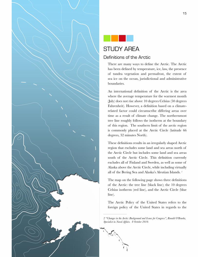
STUDY AREADefinitions of the Arctic
There are many ways to define the Arctic. The Arctic has been defined by temperature, ice, law, the presence of tundra vegetation and permafrost, the extent of sea ice on the ocean, jurisdictional and administrative boundaries.
An international definition of the Arctic is the area where the average temperature for the warmest month (July) does not rise above 10 degrees Celsius (50 degrees Fahrenheit). However, a definition based on a climate-related factor could circumscribe differing areas over time as a result of climate change. The northernmost tree line roughly follows the isotherm at the boundary of this region. The southern limit of the arctic region is commonly placed at the Arctic Circle (latitude 66 degrees, 32 minutes North).
These definitions results in an irregularly shaped Arctic region that excludes some land and sea areas north of the Arctic Circle but includes some land and sea areas south of the Arctic Circle. This definition currently excludes all of Finland and Sweden, as well as some of Alaska above the Arctic Circle, while including virtually all of the Bering Sea and Alaska’s Aleutian Islands. 2
The map on the following page shows three definitions of the Arctic: the tree line (black line); the 10 degrees Celsius isotherm (red line), and the Arctic Circle (blue line).
The Arctic Policy of the United States refers to the foreign policy of the United States in regards to the
2 “Changes in the Arctic: Background and Issues for Congress”, Ronald O’Rourke, Specialist in Naval Affairs. 8 October 2010.

16 Alaska Deep-Draft Arctic Port System Study
Arctic region. Section 112 of the Arctic Research and Policy Act of 1984 (Title I of P.L. 98-373 of July 31,1984) defines the Arctic as follows:3
As used in this title, the term “Arctic” means all United States and foreign territory north of the Arctic Circle and all United States territory north and west of the boundary formed by the Porcupine, Yukon, and Kuskokwim Rivers [in Alaska]; all contiguous seas, including the Arctic Ocean and the Beaufort, Bering, and Chukchi Seas; and the Aleutian chain.
This definition, which is codified at 15 U.S.C. 4111 includes certain parts of Alaska below the Arctic Circle,
3 “Changes in the Arctic: Background and Issues for Congress”, Ronald O’Rourke, Specialist in Naval Affairs. 8 October 2010.
including the Aleutian islands and portions of central and western mainland Alaska, such as the Seward Peninsula and the Yukon Delta.
As illustrated below, the aquatic portion of the Arctic encompasses several distinct water bodies, each of which possesses characteristics that influence the level of Marine Transportation System capabilities necessary to meet statutory mandates in U.S. Arctic policy.
Many scientists define the Arctic region as the area north of the Arctic Circle (66° 32’N), the approximate limit of the midnight sun and the polar night. The Arctic Monitoring and Assessment Programme (AMAP), a working group of the Arctic Council, adopted the following Arctic definition: “essentially includes the terrestrial and marine areas north of the Arctic Circle (66°32’ N), and north of 62° N in Asia and 60° N in North America, modified to include the marine areas north of the Aleutian chain, Hudson Bay, and parts of the North Atlantic, including the Labrador Sea.”
Some observers use the term “high north” as a way of referring to the Arctic. Other observers make a distinction between the “high Arctic” – meaning, in general, the colder portions of the Arctic that are closer to the North Pole – and other areas of the Arctic that are generally less cold and further away from the North Pole, which are sometimes described as the low Arctic or the subarctic.4
The Arctic Council based the recent May 2011 Search and Rescue (SAR) agreement on the AMAP definition of the Arctic. The Agreement on Cooperation on Aeronautical and Maritime Search and Rescue in the Arctic, or in short the Arctic Search and Rescue Agreement, is an international agreement concluded among the member states of the Arctic Council – Canada, Denmark, Finland, Iceland, Norway, Russia, Sweden and the United States – on 12 May, 2011. It
4 “Changes in the Arctic: Background and Issues for Congress”, Ronald O’Rourke, Specialist in Naval Affairs. 8 October 2010.
Map of the ArcticThe Perry-Castañeda Library Map Collection. The treeline was added at National Snow and Ice Data Center based on information from National Geographic 1983, Armstrong et al. 1978, and Young, 1989

17
coordinates international search and rescue coverage and response in the Arctic, and establishes the area of SAR responsibility of each state party. In view of the conflicting territorial claims in the Arctic, the treaty provides that “the delimitation of search and rescue
regions is not related to and shall not prejudice the delimitation of any boundary between States or their sovereignty, sovereign rights or jurisdiction.”
The Arctic Search and Rescue Agreement is the first international binding agreement negotiated under the auspices of the Arctic Council. This agreement reflects the Arctic region’s growing economic importance as a result of its improved accessibility due to global climate change.5
USACE/DOT&PF Arctic Ports Charrette – Arctic Descriptions
During the USACE/DOT&PF Alaska Deep-Draft Arctic Ports Planning Charrette held on May 16-17, 2011, participants were asked how they “define the Arctic,” for purposes of identifying the Alaska study area for future port planning efforts. Using large-scale maps of Alaska and surrounding Arctic waters, participants engaged in a broad-ranging discussion of Arctic boundaries. Below are a few comment highlights:
• Dr. Lawson Brigham, UAF, defined the Arctic as all locations with ice cover.
• Some defined the Arctic as north of the Aleutian Chain, excluding the existing deep- water port at Dutch Harbor. Others included the Aleutians and recognized that there will be more than one port solution in the Arctic, including Dutch Harbor, and possibly Russian and Canadian ports.
• All agreed that the Bering Straits are the focal point that needs priority attention for both north and southbound marine traffic.
5 Koring, Paul (12 May 2011). “Arctic treaty leaves much undecided”. Globe and Mail. http://www.theglobeandmail.com/news/world/americas/arctic-treaty-leaves-much-undecided/article2017510/. Retrieved 13 May 2011.
Arctic Search and Rescue Agreement Illustrative Map
Arctic Boundary as defined by the Arctic Research and Policy Act (ARPA)Arctic Monitoring and Assessment Programme (AMAP)

18 Alaska Deep-Draft Arctic Port System Study
• Many used the Arctic Circle as the boundary, including the northern seas.
• Nunivak Island was considered the southern boundary of an Arctic that is now unserved by deep-water ports.
• The USCG base in Kodiak serves the entire coast of Alaska.
Alaska Deep-Draft Arctic Ports System Study Area
For purposes of this Alaska Deep-Draft Arctic Ports For purposes of this study, the study area includes the state’s Arctic waters west and north of Bethel and then east to the Canadian border. Based upon existing definitions of the Arctic as well as the comments from the May 2011 Deep-Draft Ports Planning Charrette, this specific study area was selected as being of highest need for marine
infrastructure projects, as other areas of the state have some availability for vessel moorage and/or anchorage.
Currently, there are deep-draft ports in Anchorage, Seward, Valdez, Kodiak, Unalaska and Homer, but none along Alaska’s Arctic coastline.
Each of the candidate port sites referenced in the January 2012 Northern Waters Task Force Report is included in this study area. Bethel and Cape Darby are included because they are noted in the DOT&PF Roads to Resources Program. While Dutch Harbor and Adak are not part of the Arctic Port Study area, they do play a role as a staging center for Arctic maritime purposes and will play a key role in trans-shipment activities in support of Arctic operations.
POINT FRANKLIN
BARROW
CAPE THOMPSON
WAINWRIGHT
RED DOG PORT
KOTZEBUE
PORT CLARENCE
NOME
CAPE DARBY
SAINT MICHAEL
BETHELMEKORYUK
PRUDHOE BAYMARY SACHS ENTRANCE
CANADA
RUSSIA
Gulf of Alaska
Beaufort Sea
Bering Sea
Bristol Bay
Chuk
chi S
eaST LAWRENCE ISLAND
ST MATTHEW ISLAND
NUNIVAK ISLAND
ST PAUL
ST GEORGE
Alaska Deep-Draft Arctic Port Study Area Map

19
Potential Port Sites In 2010, the Alaska State Legislature established the Alaska Northern Waters Task Force (NWTF) to identify opportunities to increase the state’s engagement in Arctic international issues, northern shipping routes, mineral extraction, oil and gas exploration, commercial fishing, and tourism. The NWTF held town-hall meetings throughout the state to gather public opinion about these challenges and opportunities.
The report was released in January 2012, listing eleven potential deep-draft port sites. The study team honored the work of the NWTF and started with this shortlist of potential sites. A brief description is included to characterize each site.
1. St. Paul Island in the Pribilof Islands. St. Paul is the largest of the Pribilof Islands located in the Bering Sea. The island is volcanic in origin and covers about 40 square miles. There is an existing harbor for the Central Bering Sea fishing fleet and
fish processing facilities. Seafood companies process cod, crab, halibut, and other seafood. In 2011, 24 residents held commercial fishing permits for halibut and salmon. Several offshore processors are serviced out of St. Paul. The community developed a halibut-processing facility. Fur seal rookeries and more than 210 species of nesting sea birds attract several hundred visitors to this remote location. There is also a reindeer herd on the island from a previous commercial venture. Residents subsist on halibut, fur seals (1,645 may be taken each year), reindeer, ducks, seabirds, marine invertebrates, plants, and berries. The climate of St. Paul is Arctic maritime. The Bering Sea location results in cool weather year-round and a narrow range of mean temperatures, varying from 19 to 51 °F. Heavy fog is common during summer months.
2. St. Lawrence Island. St. Lawrence is located south of the Bering Strait. There are two communities on the island: Savoonga and Gambell.
Image courtesy USCG visual information gallery

20 Alaska Deep-Draft Arctic Port System Study
The island is the sixth largest island in the United States at 90 miles long and between 8-22 miles wide. The island has no trees and is thought to be one of the exposed portions of the land bridge that once joined Asia and North America. By community intention, there is no existing seaport on St. Lawrence Island. The island has been inhabited intermittently for the past 2,000 years by Yup’ik Eskimos. In 1900, a herd of reindeer was moved to the island, and by 1917 the herd had grown to over 10,000 animals. A reindeer camp was established in 1916 at the present village site, where grazing lands were better, and the herd tended to remain. Good hunting and trapping in the area attracted more residents. A post office was established in 1934. When the Alaska Native Claims Settlement Act (ANCSA) was passed in 1971, Gambell and Savoonga decided not to participate and instead opted for title to the 1.136-million acres of land in the former St. Lawrence Island Reserve. The island is jointly owned by Savoonga and Gambell. The economies of Savoonga and Gambell are largely based upon subsistence hunting of walrus, seal, fish, and bowhead and gray whales, with some cash income. In 2011, 13 Savoonga residents held commercial fishing permits, and a seafood plant operates in Savoonga. Reindeer harvests occur, but the herd is not managed. Fox are trapped as a secondary source of income. Islanders are known for their quality ivory carvings. The abundant number of seabird colonies provides an opportunity for limited tourism by bird-watchers.
Current activity: At the Arctic Imperative Summit, St. Lawrence Island elder, June Walunga, General Manager of the Native Village of Gambell, discussed the potential conflicts between subsistence use of the surrounding waters and the increased marine traffic in the Bering Sea. There is a USACE boat ramp project in Savoonga that is currently on hold.
3. Nome. Nome lies along the Bering Sea on the south coast of the Seward Peninsula, facing Norton Sound. It is 102 miles south of the Arctic Circle and 161 miles east of Russia. The area encompasses 12.5 square miles of land. A medium-draft port exists at Nome. Nome is a regional center of trade, health care, and education for 23 outlying communities within the Bering Strait-Norton Sound area, and is also homeport to a commercial fishing fleet, and a vital commercial transportation fleet of more than 40 vessels that regularly use the harbor and the causeway structure. The population of Nome is a mixture of Inupiat Eskimos and non-Natives. Although some employment opportunities are available, subsistence activities are prevalent in the community. Former villagers from King Island also live in Nome. Nome is the finish line for the 1,100-mile Iditarod Trail Sled Dog Race from Anchorage, held each March. In 2011, 43 residents held commercial fishing permits in a variety of fisheries. Retail services, transportation, mining, medical, and other businesses provide year-round income. Several small gold mines continue to provide employment, and Bering Straits is developing a mine eight miles north of Nome.
Current activity: Recent meetings with Mayor Denise Michels from the City of Nome indicate that there is potential to expand the existing Nome causeway and related breakwater to accommodate deep-draft vessels. City records document the increased traffic from 30 docked vessels in 1988 to 304 vessels in 2011. Nome’s proximity to oil and gas activity along with mining operations and developed uplands create an opportunity for deep-draft operations. $10 million for Nome Port design and construction is included with the enacted (November 2012 election) state port bond legislation (SCS CSHB 286(FIN). The City has requested $77 million for a deep-draft port. In 2012, a very large graphite deposit was discovered near Teller. However, it is not in production yet and the permitting process is expected to take a long time.

21
4. Port Clarence/Teller. Port Clarence is a federal work site, located on a long spit near the western entrance, and was established to operate Coast Guard LORAN equipment. Teller is 15 miles across the enclosed harbor and is located on a small spit between Port Clarence and Grantley Harbor on the Seward Peninsula. Teller has a lighted runway and is further accessible by a seasonal 72-mile road south to Nome. Teller encompasses 1.9 square miles of land. Deeper water (up to -35 feet) is located in the western side of Port Clarence. Teller, on the east side, is less deep, but offers a chance to lighter ashore and access the services in Nome (hospital, businesses, daily jet air travel). The natural protection offered within Port Clarence and its proximity to Bering Strait, has led to the use of this natural harbor since whaling vessels were active in the region in the 1860’s. It is currently used by
barge operators as they await ice retreat north of Bering Strait each summer.
The Seward Peninsula has a maritime climate with continental influences when the Bering Sea freezes. The Teller economy is based on subsistence activities supplemented by part-time wage earnings. Fish, seal, moose, beluga whale, and reindeer are the primary meat sources. There is a herd of over 1,000 reindeer in the area, and the annual roundup provides meat and cash income. In 2011, six Teller residents held commercial fishing permits. Over one-third of households produce crafts or artwork for sale, and some residents trap fox.
Current activity: Meetings with Matt Ganley of Bering Straits Native Corporation (BSNC) confirmed that BSNC is in the process of securing conveyance of
Imag
e co
urte
sy U
SCG
vis
ual i
nfor
mat
ion
galle
ry

22 Alaska Deep-Draft Arctic Port System Study
lands at the former USCG Loran facility at Port Clarence, located about 67 miles northwest of Nome. The property was selected by BSNC in the 1970’s in partial fulfillment of its land entitlement under the Alaska Native Claims Settlement Act (1971).
BSNC has been working with Crowley Maritime Corporation on a deep-water port development plan. They note that infrastructure development at Port Clarence would provide economic benefits not only to their shareholders, but to all of the region’s residents. Port Clarence could provide a base of operations for search and rescue needs, and staging for disaster response. The strategic location of Port Clarence also provides assurance of rapid international environmental response capabilities as the Bering Straits shipping lanes experience increased traffic due to the opening of the Arctic Ocean sea routes.
5. Kotzebue/Cape Blossom. Kotzebue lies on a 3-mile long gravel spit at the end of Baldwin Peninsula. It is located near the discharges of the Kobuk, Noatak, and Selawik Rivers, 26 miles above the Arctic Circle. Kotzebue serves as a supply hub for 10 satellite villages, with a regional population of about 7,800. The area encompasses 27 square miles of land. A shallow-draft port complex exists at Kotzebue. Since Cape Blossom is close to deep water, during the ice-free season, deep-draft freighters anchor 15 miles out to sea and cargo is lightered to port. Kotzebue has a healthy cash economy, a growing private sector, and a stable public sector. Due to its location at the confluence of three river drainages, Kotzebue is the transfer point between ocean and inland shipping. Kotzebue Sound is ice-free from early July to early October. It is also the air transport center for the region. Activities related to oil and minerals exploration and development have contributed to
Nome, Alaska with hospital in background© Joseph A Davis, ConsultNorth

23
the economy. The majority of income is directly or indirectly related to government employment. The Cominco Alaska Red Dog Mine is a significant regional employer. Commercial fishing for chum salmon provides some seasonal employment. Most residents rely on subsistence to supplement income.
Current activity: Cape Blossom offers a potential deep-draft port site, and is classified by USCG as safe harbor and a port of refuge. Recent meetings with Mayor Eugene Smith and his staff confirmed that the City of Kotzebue is actively pursuing development of a 10-mile road and deep-water port at Cape Blossom to limit the lightering distance and substantially reduce the costs of shipping for local residents and business. The U.S. Marine Corps completed a ground topographic study in 2010. Soil studies and bathymetric data has been gathered by DOT&PF. The City expects to begin an Environmental Assessment (EA) in 2013. Per the Statewide Transportation Improvement Plan (STIP), DOT&PF is scheduled to start construction of the $30 million road from Kotzebue to Cape Blossom in 2014. The Mayor noted that expressions of interest have been received for LNG and copper export. Cape Blossom road and deep-water port development are included in the state’s enacted bond package for a value of $10 million.
6. Mekoryuk. Mekoryuk is at the mouth of Shoal Bay on the north shore of Nunivak Island in the Bering Sea. The island lies 30 miles off the coast. Mekoryuk is part of the Yukon Delta National Wildlife Refuge. The area encompasses 7.4 square miles. Mekoryuk has no boat harbor but does have moorage for small boats protected by a breakwater. Most wage-earning employment is offered by the school, city, village corporation, commercial fishing, construction, and service industries. The Bering Sea Reindeer Products Company is a major employer. Trapping and Native crafts, such as knitting qiviut (musk ox underwool) provide income to many
families. In 2011, 47 residents held commercial fishing permits, primarily for halibut and herring roe. Coastal Villages Seafood Inc. processes halibut and salmon in Mekoryuk. Almost all families engage in subsistence activities, and most have fish camps. Salmon, reindeer, seal meat, and oil are important subsistence staples.
Current activity: Native Village of Mekoryuk received a $50,000 grant from the State of Alaska designated legislative grant agreement for researching potential possibility of a deep water port on Nunivak Island. The community of Mekoryuk has worked collectively since the mid 1990’s in researching, working, and promoting the idea to state and federal agencies. With the discussion of the Northwest passage, Nunivak residents are hopeful of such a port. Representatives from the tribal government will be attending port discussions and meetings in the near future.
7. Cape Thompson. Cape Thompson is a headland located on the Chukchi Sea about 26 miles southeast of Point Hope. It is part of the Chukchi Sea unit of the Alaska Maritime National Wildlife Refuge. The site is located on a promontory with bulk rip-rap and aggregate potential and is broadly sheltered from the north by the spit of Point Hope. It has an old airstrip but is otherwise largely undeveloped. Cape Thompson gained notoriety in 1958 as the proposed site for an artificial harbor to be dug by nuclear bombs known as “Project Chariot”. The proposal was never implemented.
Current activity: Potential development of a port at Cape Thompson in partnership with AIDEA was announced by Chairman Crawford Patkotak of ASRC at the Arctic Imperative Summit, and later discussed with ASRC staff. Arctic Slope Regional Corporation, (ASRC), is an Alaskan native corporation and is owned by and represents the business interests of its Inupiaq shareholders. The
Nome, Alaska with hospital in background© Joseph A Davis, ConsultNorth

24 Alaska Deep-Draft Arctic Port System Study
Corporation owns title to approximately five million acres of land on the North Slope of Alaska and is interested in conducting an initial site selection study and baseline assessment for a greenfield Arctic port located on their acreage or directly seaward at Cape Thompson, along the Chukchi Sea coast of Alaska. This location is to be considered primarily as a potential port for a terminal associated with shipping of extraction minerals, gas and potentially a Coast Guard hub.
8. Wainwright. Wainwright is the nearest village to the Chukchi Sea OCS leases and is located on Wainwright Inlet, which is capable of sheltering shallow- to medium-draft vessels. The Chukchi Sea is ice-free from mid-July through September. Wainwright is located 72 miles southwest of Barrow. The city presently does not have a seaport. The region around Wainwright was traditionally well-populated, though the present village was not established until 1904, when the Alaska Native Service built a school and instituted medical and other services. The site was reportedly chosen by the captain of the ship delivering school construction materials, because sea-ice conditions were favorable for landing. Coal was mined at several nearby sites for village use. Economic opportunities in Wainwright are influenced by its proximity to Barrow and the fact that it is one of the older, more established villages. Most of the year-round positions are in borough services. Sale of local Eskimo arts and crafts supplements income. Bowhead and beluga whale, seal, walrus, caribou, polar bear, birds, and fish are harvested.
Current activity: The Olgoonik Corporation is based in the village of Wainwright, located within the National Petroleum Reserve Alaska and the closest village to the offshore leases in the Chukchi Sea. The proximity of oil and gas, a protected bay and an airport with passenger and cargo services gives Wainwright the capability for logistics support.
Olgoonik has been supporting oil industry activities since 2007. They are investing in equipment, infrastructure and training programs to meet industry needs with operations at an abandoned distance early warning (DEW) radar site.
9. Point Franklin. Located between Wainwright and Barrow, Point Franklin and its adjacent barrier islands may serve as a shelter and possible port site for shallow- to medium-draft vessels.
10. Barrow. Barrow, the northernmost community in the United States, is located on the Chukchi Sea coast, 10 miles south of Point Barrow. The area encompasses 18.4 square miles. With a population of more than 4000, Barrow boasts considerable infrastructure despite its remote location and is the geographic midpoint between the active exploration areas in the Beaufort and Chukchi Seas. In 1881, the U.S. Army established a meteorological and magnetic research station near Barrow. The Cape Smythe Whaling and Trading Station was constructed there in 1893. Exploration of the Naval Petroleum Reserve Number 4 (now National Petroleum Reserve in Alaska, NPR-A) began in 1946. The Naval Arctic Research Laboratory, three miles north of Barrow, soon followed. Formation of the North Slope Borough in 1972 and the Arctic Slope Regional Corporation, as well as construction of the Prudhoe Bay oilfields and Trans-Alaska Pipeline, have each contributed to the development of Barrow. Today, tax revenues from the North Slope oil fields fund borough-wide services.
Just east of Point Barrow is Eluitkaak Pass, which is the “notch” between the Barrow spit and the barrier islands of Elson Lagoon. Eluitkaak Pass is about 50 feet deep at its deepest, although it shallows at both ends toward the north and the south. Elson Lagoon, although shallow, is protected from the open ocean by barrier islands. At present there is no protected harbor at Barrow. Barrow is the economic center

25
of the North Slope Borough, the city’s primary employer, and numerous businesses provide support services to oil field operations. The midnight sun attracts tourism, and arts and crafts provide some cash income. Many residents rely upon subsistence food sources: whale, seal, polar bear, walrus, duck, caribou, grayling, and whitefish are harvested from the coast or nearby rivers and lakes.
Current activity: Meetings were held with Mayor Brower and Jacob Adams, CEO of North Slope Borough (NSB) after Mayor Brower’s presentation at the Arctic Imperative Summit and the Alaska Oil & Gas Congress. Mayor Brower spoke to the opportunity for integrating the need for development and jobs with the need for maintaining subsistence resources and limiting the risks of oil and gas development.
11. Prudhoe Bay. Prudhoe Bay is adjacent to the Beaufort Sea, east of Nuiqsut. Prudhoe Bay has been extensively developed for oil industry support. The Prudhoe Bay oil fields provide some 2-3 percent of the nation’s domestic oil supply and employ over 5,000 individuals in drilling, pipeline operations, cargo transportation, and a variety of support positions. There is a causeway and dock system on the east and west sides of Prudhoe Bay that currently services the line-haul barges that transport drilling and production infrastructure to the North Slope. The bay was named in 1828. The site was extensively developed for oil drilling operations in the 1970’s. An 800-mile pipeline was constructed to transport crude oil from Prudhoe Bay to Valdez, where it is shipped in marine tankers to terminals throughout the U.S. The pipeline has
Shoreline - Barrow, Alaska© Joseph A Davis, ConsultNorth
26 Alaska Deep-Draft Arctic Port System Study
AKUTAN HARBOR
JNU DOUGLAS HBR
UNALASKA HARBOR
PORT LIONS HBR
SAND POINT HBR CHIGNIK HARBOR
FALSE PASS HARBOR
HYDABURG HARBOR
HAINES HARBOR HOMER HBR
WHITTIER HARBOR
SITKA ANB HARBOR
LEGEND
DOT&PF matching funds for USACE projects
Municipal Harbor Facility Grants
PSG NORTH HBR
PORT OF NOME
DOT&PF debt reimbursement projects
FAIRBANKS FIRE HQ BLDG
NORTH STAR BOROUGH SCHOOL
PORT MACKENZIE
VALDEZ HARBOR
JNU STATTER HBR
PSG SOUTH HBR
SEWARD HBR
SELDOVIA HBR
SKAGWAY HBR
JNU AURORA HBR
HOONAH HARBOR
NOME HARBOR
DOT&PF projects
KODIAK FT
PORT ALEXANDER HBR
ELFIN COVE HBR TENAKEE SPRINGS HBR
NAUKATI HBR
12 pump stations and a maximum capacity of two million barrels of crude oil per day. The community, primarily oil industry employees, is connected year-round to the North American road system by the Dalton Highway.
12. Mary Sachs Entrance. This is a channel between barrier islands located about 60 miles north and east of Prudhoe Bay. There is no active community at the site.
In response to the DOT&PF’s Roads to Resources Program, two more sites were added to the list:
Bethel is an active community resupply port for the Kuskokwim River and delta area. Bethel is located at the mouth of the Kuskokwim River, 40 miles inland from the Bering Sea and within the Yukon Delta National Wildlife Refuge. This site
was included due to the anticipated sales of more Oil and Gas leases in Bristol Bay. The harbor at Bethel is the northernmost medium draft port in the United States. Bethel is the main port on the Kuskokwim River and is an administrative and transportation hub for 56 villages on the Yukon-Kuskokwim Delta. Food, fuel, transportation, medical care, and other services for the region are provided by Bethel. Commercial fishing is an important source of income. In 2011, 186 Bethel residents held commercial fishing permits. Subsistence activities contribute substantially to villager’s diets, particularly salmon, freshwater fish, game birds, and berries.
Current activity: The port of Bethel was included in 2012 enacted port bond legislation for harbor dredging at a value of $4 million.
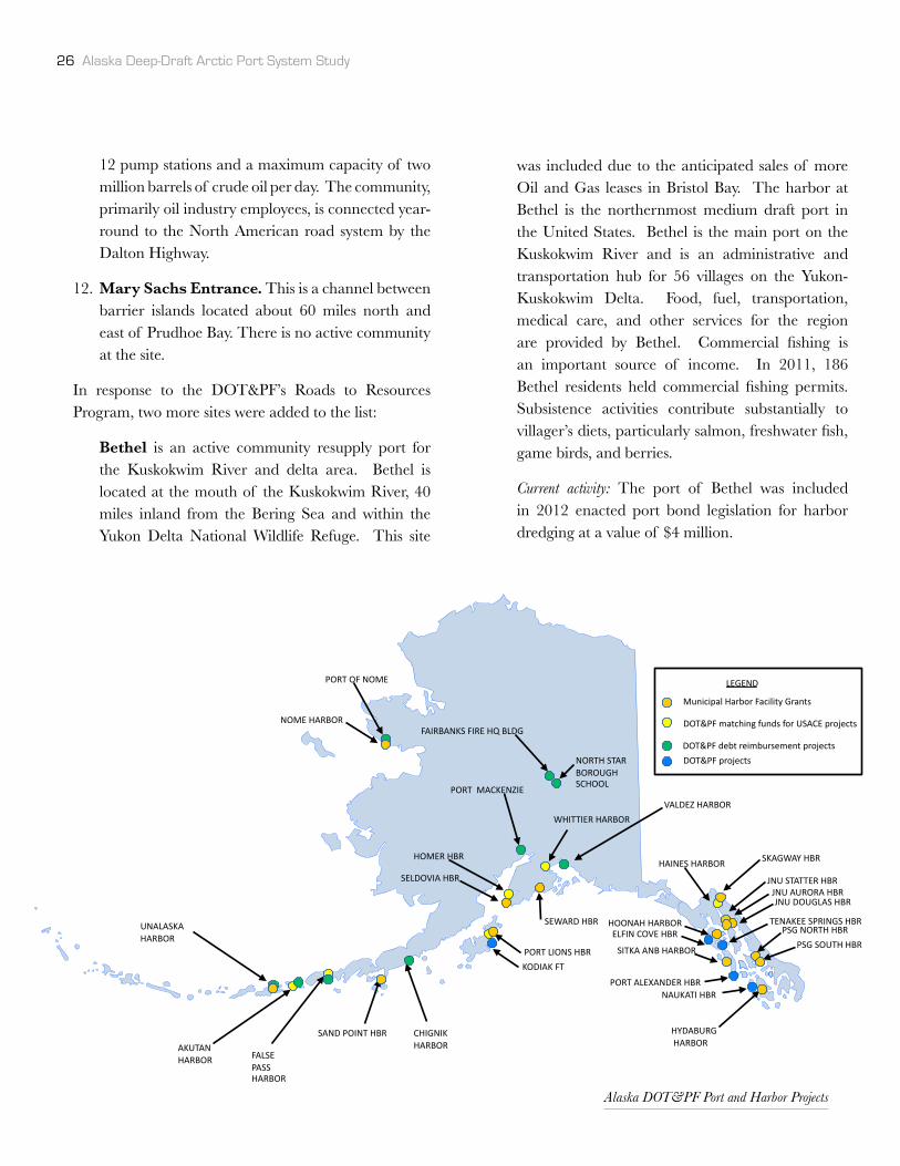
Alaska DOT&PF Port and Harbor Projects

27
Cape Darby is considered a deep-draft port potentially suited for resource export. It is one of the very few naturally deep-water ports in the study area, located between Golovin and Elim. There is no related community or infrastructure at this site. There are several prospect discovery and metals mines near Cape Darby: Windy Creek; Omilak; Otter Creek Lode; Omilak East; Foster; Darby Mountains; Ektookook; Fish; Burnt Creek; Kachauik; Limestone Cliffs and Walla Walla. The terrain is rugged and likely to be a suitable source of material for construction of roadbeds and port development. There is an upland quarry adjacent to Cape Darby. If a port were located on the east side of the cape, it would have some protection from easterly winds and waves.
It is important to note this list of candidate port sites was developed as the starting point based on the existing Northern Waters Task Force and the planning and statewide outreach associated with the DOT&PF Roads to Resources. This list does not preclude future investment in other locations to support specific resource
development, risk management, community resupply or other purposes.
Current DOT&PF Port & Harbor ProjectsThere are several port and harbor improvement projects being planned/constructed to serve Southcentral Alaska, Aleutian and Pribilof Island, Bristol Bay and Southeast Alaska (See DOT&PF project map on page 26). Unalakleet Harbor and Port of Nome are the only marine projects planned within the defined study area but those will not accommodate deep-draft vessels as currently planned within the DOT&PF projects. Note the City of Nome is actively working to develop a deep-draft port by extension of existing causeway (See previous section).
Current USACE Port & Harbor ProjectsThe above map indicates the current operations and maintenance projects for the USACE. Note that there is ongoing dredging for two ports on the study shortlist: Nome and Bethel. Hydrographic surveys are underway for St. Paul Island.
USACE Alaska Operations and Maintenance Projects

28 Alaska Deep-Draft Arctic Port System Study
Nome, Alaska© Joseph A Davis, ConsultNorth

29
OTHER ARCTIC PORT PLANNING STUDIESIn addition to the history of work by USACE and DOT&PF, considerable and conscientious efforts to study, plan and understand the Arctic waters have been conducted by other agencies in recent years. At the onset of this study project, the Study Team chose to build directly on that technical and outreach work. Two of the most significant reports were the 2012 Northern Waters Task Force Report (http://housemajority.org/coms/anw/pdfs/27/NWTF_Full_Report_Color.pdf) and the 2009 Arctic Marine Shipping Assessment (www.arctic.gov/publications/AMSA.html). Both are referenced liberally within this report.
Northern Waters Task Force Report, January 2012
At both the state and federal level, the task force studied a vast quantity of scientific, social, and economic research. It consulted with more than 65 experts from universities, the U.S. military, non-governmental organizations, and dozens of state and federal agencies. During twelve meetings in Juneau, Anchorage, Barrow, Wainwright, Kotzebue, Nome, Wales, Bethel, and Unalaska, the task force listened to thoughtful testimony delivered by hundreds of Alaskans, many already impacted by transforming conditions.6
The four main Alaska Northern Waters Task Force recommendations for Arctic planning and infrastructure investment are:
• Forward base the Coast Guard in the Arctic• Fund additional icebreakers and other ice-capable
vessels• Continue the analysis and development of ports
and safe harbors in the Arctic • Support Search & Rescue coordination centers
along the coast to assist Federal, state, and local responders
6 Northern Waters Task Force Report, January 2012

30 Alaska Deep-Draft Arctic Port System Study
2009 Arctic Marine Shipping Assessment ReportThe Arctic Council conducted a comprehensive Arctic Marine Shipping Assessment of current and future Arctic marine activity. “More than 185 experts participated directly in the work of the AMSA. Thirteen major AMSA workshops were held from July 2006 through October 2008 on a broad range of relevant topics, including scenarios of future Arctic navigation, indigenous marine use, Arctic marine incidents, environmental impacts, marine infrastructure, Arctic marine technology and the future of the Northern Sea Route and adjacent seas.”
The AMSA recommendations are presented under three broad, inter-related themes that are fundamental to understanding the AMSA: Enhancing Arctic Marine Safety, Protecting Arctic People and the Environment, and Building Arctic Marine Infrastructure.
• Infrastructure. In terms of addressing the infrastructure deficit, AMSA recommended that the Arctic states should recognize that improvements in Arctic marine infrastructure are needed to enhance safety and environmental protection in support of sustainable development. Examples of infrastructure where critical improvements are needed include: ice navigation training; navigational charts; communications systems; port services, including reception facilities for ship-generated waste; accurate and timely ice information (ice centers); places of refuge; and icebreakers to assist in response.
• Marine traffic awareness. AMSA recommended that the Arctic states should support continued development of a comprehensive Arctic marine traffic awareness system to improve monitoring and tracking of marine activity, to enhance data sharing in near real-time, and to augment vessel management service in order to reduce the risk of incidents, facilitate response, and provide awareness of potential user conflict.
• Research. AMSA also recommended that the Arctic states should significantly improve the level of and access to data and information in support of safe navigation and voyage planning in Arctic waters, such as: hydrographic surveys and systems to support real time acquisition, analysis and transfer of meteorological, oceanographic, sea ice and iceberg information.
Resource List of Current Arctic Studies/Projects Addressing the opportunities and challenges of the Arctic was one of the intense Alaska issues in 2012. Many meetings and conferences were held to bring stakeholders together for collaboration and engagement. Members of the Study Team attended over 250 hours of Arctic-related meetings in 2012 to stay abreast of parallel efforts, avoid duplication, communicate the goals and scope of this study, and exchange thinking with affected stakeholders and their projects. Current studies are identified in Appendix A-1.
Bibliography of Arctic ResearchDue to the intense interest in the Arctic and Alaska’s water infrastructure, there have been many detailed studies and reports developed in recent years by a multitude of organizations (Arctic Council, Northern Waters Task Force, NOAA, Institute of the North, University of Alaska, et al). Included in Appendix A-2 is a bibliography of related Arctic reports and studies.

31
PORT SITE EVALUATION The enhanced Arctic port system must meet the needs of multiple users with various missions and differing technical specifications. After identification of the candidate sites (page 19), the Study Team worked to develop the criteria for evaluation of the physical suitability of each of the sites.
Multi-Criteria Decision Analysis Tool An independent software tool was used to support objectivity in the technical evaluation of the physical conditions at each site. The selected Multi-Criteria Decision Analysis (MCDA) tool developed by the Institute of Water Resources was used in this effort.
MCDA can be applied to decision-making problems in a variety of areas. MCDA is a decision-analysis tool, not a decision-making tool. It provides a vehicle to compare criteria of different units (apples to oranges) and to weight the criteria as an aid in the planning process. MCDA is a powerful tool to structure complicated comparisons quickly.
The insights and outcomes of this physical evaluation highlighted a number of sites. Parallel to this technical desktop evaluation, there was extensive engagement with the world of Arctic meetings and stakeholders operating in the context of current conditions and actual investments. The results of the MCDA evaluation support what those operating in the Arctic also recommend.

32 Alaska Deep-Draft Arctic Port System Study
Evaluation Criteria Based on input from the 2011 Arctic Ports Charrette, the Study Team developed the site selection criteria and articulated the variables for comparison. The following section outlines each of the criteria and its related variables. Detailed evaluation summaries for each criterion and candidate site are in Appendix A-4.
1. Port Proximity to Mission (Oil and Gas, and Mining as key drivers)
2. Intermodal Connections
3. Upland Support
4. Natural Water Depth
5. Navigation Accessibility (wind, wave, ice conditions)
6. Other Factors (Sovereignty, Roads, Environmental/NEPA, Maintenance, Harbors of Refuge, Land Ownership)
Port Proximity
Port Proximity was measured in distance from the Outer Continental Shelf (OCS) oil and gas endeavors, mining operations and potential, existing oil spill response equipment, community resupply, and shipping lanes. Alaska DEC developed a series of maps for potential places of refuge as part of their contingency planning and these were used to determine existing spill response equipment.7
Intermodal connections
Intermodal connections for jet service or C-130 – gravel runways – were measured within 100 miles of the communities. The Federal Aviation Administration airport facilities data was used to determine this criterion.8 Consideration was also given to the potential for road and rail connections. The team also added a criterion to indicate if there were any existing marine
7 http://dec.alaska.gov/spar/perp/index.htm
8 www.faa.gov/airports/airport_safety/airportdata_5010/menu/index.cfm.
infrastructure with the understanding the existing harbors are not adequate for deep-draft vessels.
Upland Support
Upland support was measured by whether the community is considered a hub, one that supports other communities in the area. Hubs were identified based on their ability to support other communities. A major hub supports many other communities, a regional hub supports the immediate geographic area, a minor hub supports a couple of other communities and the community designation means that most goods are consumed within the community.
Water Depth
Water depth was measured as a function of natural depth from shore. Using the natural water depth was deemed appropriate as a means of avoiding ongoing maintenance dredging and cost. Minus 35-feet mean lower low water (MLLW) and minus 45-feet MLLW were deemed appropriate depth measures to capture suitability for various deep-draft port users. If the distance to deep water was less than a half-mile, the site ranked as 5, between a half-mile and one mile was 4, one to two miles was 3, two to five miles was 2, five to 10 miles was 1, and more than 10 miles was 0. Total ranking for these criteria was the sum of both ranks (minus 35-feet and minus 45-feet). National Oceanic and Atmospheric Administration (NOAA) maps were used for water depth estimates with population centers deemed as the most likely spot for a deep-draft port site.
Navigation Accessibility
Navigation accessibility was measured as very good, good, medium, low, very low, and potential for ice season (months free of ice) and other operational considerations (weather, wind, wave, tides, and currents). Engineers familiar with Alaska conditions were queried on each of the 14 sites in order to assign values to this criterion.
33
Other Factors
Other factors that were considered initially as Arctic deep-draft port siting criteria include Sovereignty, roads, National Environmental Protection Act (NEPA) considerations, future maintenance, harbor of refuge, and land ownership issues. The team had a lengthy discussion of including cost as one of the criteria, but at this point in the study there is insufficient information available for accurate cost estimates. Once sites are selected and construction alternatives are developed, then cost should and will be used as a criterion in final selection for the “best” alternative(s) for construction. Distance to deep water was deemed a suitable proxy for cost and in the final array, this criterion was given additional weighting in order to capture the cost element.
Port MissionIn addition to the criteria, the Study Team determined that weighting of each criterion would vary depending on the port purpose. Again, based on stakeholder input, six individual port purposes were envisioned.
It was noted that private industry was expected to lead the siting. Their decisions are led by making the business case, with proximity to resources and quantity of resources present as the primary drivers. Federal and public safety interests can be met at many sites, existing and new. The primacy of the private industry investment was demonstrated during the course of the study as Crowley and Bering Straits Native Corporation indicated that they were designing port facilities for OCS oil and gas operations support at Port Clarence,
Imag
e co
urte
sy U
SCG
vis
ual i
nfor
mat
ion
galle
ry
34 Alaska Deep-Draft Arctic Port System Study
and ASRC announced study with AIDEA of port potential for future coal export near Port Thompson.
• Oil and gas industry support – Shell Oil is drilling in the Chukchi Sea and it is expected other oil companies will follow in 2013. One private support company envisioned that the Chukchi Sea operation could grow to about half the size of the Gulf of Mexico. There is limited infrastructure to support worker transfer, supply delivery, and other assistance in the Arctic area. Liquefied Natural Gas (LNG) export is also a potential but has limited need for a deep-draft port as pipelines are a more cost-effective means of transport, unless the gas is going to be exported to an overseas market.
• Bulk mineral export – The Governor’s proposed Roads to Resources Program could be supported with water infrastructure for bulk export of mineral resources, including copper, coal, lead-zinc and others. While there are many potential resource locations along the Arctic coast, some are more likely to take place in the near future, and this factor was also considered.
• Community resupply – Rural Alaska communities pay high prices for fuel and supplies in western and northern Alaska. There is a need for more cost-effective shipping solutions.
• National sovereignty – There is increased international traffic along the U.S. Alaskan shores and there are limited facilities to support national agencies to monitor and maintain a presence. Russia is currently building 10 harbors of refuge on its eastern boundary.
• Safety: Search and Rescue, incident response, and environmental protection – Increased marine traffic means increased risks of incidents. Access to equipment and port facilities is needed to protect people and the environment.
• Federal mission support – Navy, Coast Guard, NOAA, and other research vessels are traveling the northern waters with little or no infrastructure support. The agencies have each expressed interest in utilizing a deep-draft port and enhanced
port facilities, but they lack funding and authority to build such infrastructure. Long term Federal leases could provide a partnership opportunity.
Port Site Technical AnalysisThe physical conditions were determined for each criterion and for each site. A narrative summary of the outcome of the evaluation is displayed on the following matrix. This format allows for comparison. For more detailed analysis, see Appendix A-4.
Investment Context The above port sites were selected based on evaluation of physical criteria that support a well-functioning and cost-effective port. As noted earlier, public and private investments are already actively underway in many existing and planned ports of the Arctic system. These investments are being made by private industry, as well as public sector for community port facilities. Ideally, regardless of the initiating party, both public and private sector interests will collaborate to invest in multiple port facilities. This will enhance the Arctic port system and fulfill the range of goals from sovereignty and economic development to community resupply, search and rescue, and potential environmental protection.
Private InvestmentBering Straits Native Corporation (BSNC) confirmed that BSNC is in the process of securing conveyance of lands at the former USCG Loran facility at Port Clarence, located about 67 miles northwest of Nome. The property was selected by BSNC in the 1970’s in partial fulfillment of its land entitlement under the Alaska Native Claims Settlement Act (1971).
BSNC has been working with Crowley Maritime Corporation on a deep-water port development plan. They note that infrastructure development at Port Clarence would provide economic benefits not only to their shareholders, but for all of the region’s residents.
35
Port Clarence could provide a base of operations for search and rescue needs, and staging for incident response. The strategic location of Port Clarence also provides assurance of rapid international environmental response capabilities as the Bering Straits shipping lanes experience increased traffic due to the opening of the Arctic Ocean sea routes.
Arctic Slope Regional Corporation (ASRC) announced in August 2012 at the Arctic Imperative Meetings that they are working with AIDEA to evaluate port suitability for potential resource export. ASRC is an Alaskan native corporation owned by and representing the business interests of its Inupiaq shareholders. The Corporation owns title to approximately 5 million acres of land on the North Slope of Alaska and is conducting an initial site selection study and baseline assessment for a greenfield Arctic port located on their acreage or directly seaward at Cape Thompson, along the Chukchi Sea coast of Alaska. This location is to be considered primarily as a potential port for a terminal associated with shipping of extraction minerals, gas, and potentially a Coast Guard hub.
Guggenheim Partners and other private investment funds have participated in the Arctic Imperative Summit and other Arctic policy meetings over the last two years. There is interest in investment in Arctic infrastructure associated with resource development, including ports.
Community Investment A number of ports in the state’s legislation authorizing the issuance of general obligation bonds received voter approval in November 2012. Communities continue to pursue development of their ports for more cost-effective resupply, safety, and to encourage economic development in their regions.
Nome. The City of Nome indicated that there is potential to expand the Nome causeway to accommodate deep-draft vessels. Recent hydrographic surveys done to support the Renda’s fuel delivery revealed that deep-
Port Site Short List Based on the technical criteria and the MCDA analysis, below are the top sites from three perspectives: All Purposes, Oil & Gas and Mining. Water Depth and Navigation are the most important physical criteria for determining port suitability for investment. It is notable that Nome and Port Clarence (Teller) are listed in the top spots in nearly all the runs through the MCDA model. Please see Appendix A-4 for more detail. Cape Darby ranked high due to its naturally deep water. Barrow ranked high due to the quality of the upland support system.
All purposes, all criteria, equal weights
1. Nome2. Port Clarence (Teller)3. Cape Darby
Oil & Gas Sites – water depth limited to minus 35-feet
1. Nome2. Port Clarence (Teller)3. Barrow
Mining Sites – water depth limited to minus 45-feet
1. Nome2. Cape Darby3. Port Clarence (Teller)
All of the sites evaluated during this site selection process are in need of improved marine infrastructure development. Some sites provide natural conditions and proximity to natural resource extraction that would enhance the Deep-Draft Arctic port system. Two sites, Nome and Port Clarence (Teller), have a clear link with a road, support to ongoing oil and gas endeavors, and were the highest scoring overall in the site selection process. These two sites have been selected for the initial feasibility study. The Corps and the State will endeavor to initiate additional feasibility study evaluations as time and funding allow.

36 Alaska Deep-Draft Arctic Port System Study
uplands facilities to support equipment and personnel, as well as development of production facilities.
State Bond FY2013
House Bill 286 is State of Alaska legislation “providing for and relating to the issuance of general obligation bonds for the purpose of paying the cost of state transportation projects; and providing for an effective date.” Of those located within the Arctic Port study area, bond projects were proposed for the November 2012 ballot, and subsequently approved:
• Bethel – Harbor Dredging $4 million
• Emmonak – Port Improvements$3 million
• Hooper Bay – Boat Harbor$1 million
• Nome – Port Design & Construction$10 million
• Kotzebue, Cape Blossom Road and Deep-Water Port
$10 million
water is closer than anticipated. Nome’s proximity to oil and gas activity along with mining operations and developed uplands are an attractive choice for deep-draft operations. The current Gold Rush has brought international mining operations to the area. The results of private environmental baseline studies by Ashanti and DeBeers will be shared with the City of Nome to support the proposed causeway extension. $10 million for Nome Port design and construction is included in the enacted (November 2012 election) state port bond legislation (SCS CSHB 286(FIN)).
Kotzebue. Cape Blossom offers a potential deep-draft port site, and is classified by USCG as safe harbor and a port of refuge. Recent meetings with Mayor Eugene Smith and his staff confirmed that the City of Kotzebue is actively pursuing development of their deep-water port at Cape Blossom to limit the lightering distance and substantially reduce the costs of shipping for local residents and business. The City expects to begin an Environmental Assessment (EA) in 2013. Per the Statewide Transportation Improvement Plan (STIP), The Alaska Department of Transportation is scheduled to start construction of a road from Kotzebue to Cape Blossom in 2015. The Mayor noted that expressions of interest have been received for LNG and copper export. Cape Blossom road and deep-water port development are included in the state’s recently enacted bond package at a value of $10 million.
Dutch Harbor. Oil companies and shipping officials are interested in using Dutch Harbor for trans-shipment/staging area as they prepare for work in the Arctic. The Unalaska Marine Center port is currently a deep-draft facility and can provide transshipment support services for Arctic bound vessels year round. Shell’s exploration drill barge, the Kulluk, is stationed at a custom berth in Dutch Harbor.
Adak. The former naval base at Adak is positioning as a logistics support terminal for the oil and gas industry offshore of Alaska’s North Slope. There are significant

SUMMARY EVALUATION OF CANDIDATE SITES
CRITERIA MISSION PROXIMITY INTERMODAL CONNECTIONS UPLAND SUPPORT WATER DEPTH NAVIGATION ACCESSIBILITY
Quantitative Scoring
very good = 5, good = 4, medium = 3, low =2, very low = 1, potential = 0
4=scheduled jet/existing road/harbor, 3=planned jet/road/harbor, 2=scheduled turbo prop/some marine, 1=scheduled air taxi/charter/limited road/harbor, 0=none/potential
Based hub concept:major hub = 5, regional hub = 4, minor hub = 3, community = 1, none/potential = 0
Function of distance:<=1/2 mile = 5 >1/2 and <=1 mile = 4>1 and <=2 miles = 3 >2 and <=5 miles = 2 >5 and <=10 miles =1>10 = 0
very good = 5, good = 4, medium = 3, low =2, very low = 1, potential = 0
Qualitative Description
Time and distance from OCS oil and gas endeavors, mining operations and potential, oil spill response existing, community resupply, and shipping lanes. Note that OSR is insufficient for large-scale containment.
Air service within 100 miles, jet service assumes 4,000' runway needed, gravel runway for C-130, road and rail potential is to Railbelt or other communities, harbors constitute existing marine infrastructure. “Limited road” is referencing existing road connections to other places, not roads within the community.
Based on hub concept where a major hub serves many communities, a regional hub serves a geographic region, minor hub serves some nearby communities, and a community has very little transfer of goods to areas outside its home
-35 feet (5.8 fathoms) or -45 feet (7.5 fathoms) Function of distance from shore
Months ice conditions allow traffic, and operational considerations (wind, wave, tides, currents)
CANDIDATE SITES
St. Paul Island OCS: Very lowMining: None/PotentialExisting OSR: Very lowCommunity Resupply: Very lowShipping Lanes: Very good
Air Service: Scheduled turbo propRoad: None/potentialExisting Marine: Harbor
Community Distance to -35 feet: <=1/2 mileDistance to -45 feet: >1/2 and <=1 mile
Ice Conditions: GoodOperational Considerations: Very Low
St. Lawrence Island OCS: NoneMining: NoneExisting OSR: Very lowCommunity Resupply: LowShipping Lanes: Very good
Air Service: Scheduled turbo propRoad: None/potentialExisting Marine: Limited harbor
Community Distance to -35 feet: >1/2 and <=1 mileDistance to -45 feet: >1 and <=2 miles
Ice Conditions: GoodOperational Considerations: Medium
Port Clarence/Teller OCS: MediumMining: GoodExisting OSR: GoodCommunity Resupply: Very lowShipping Lanes: Very good
Air Service: Scheduled air taxi/charterRoad: Scheduled Limited roadExisting Marine: Limited harbor
Minor Hub Distance to -35 feet: <=1/2 mileDistance to -45 feet: >1 and <=2 miles
Ice Conditions: MediumOperational Considerations: Good
Nome OCS: MediumMining: GoodExisting OSR: GoodCommunity Resupply: Very GoodShipping Lanes: Good
Air Service: Scheduled jetRoad: Limited roadExisting Marine: Harbor
Regional Hub Distance to -35 feet: <=1/2 mileDistance to -45 feet: >1/2 and <=1 mile
Ice Conditions: MediumOperational Considerations: Good
Cape Blossom (Kotzebue) Shipping Lanes: Medium Existing Marine: Limited harbor Regional Hub Distance to -45 feet: >2 and <=5 miles Operational Considerations: Good
37

SUMMARY EVALUATION OF CANDIDATE SITES
CRITERIA MISSION PROXIMITY INTERMODAL CONNECTIONS UPLAND SUPPORT WATER DEPTH NAVIGATION ACCESSIBILITY
Mekoryuk (Nunivak Island) OCS: None/PotentialMining: Very lowExisting OSR: LowCommunity Resupply: LowShipping Lanes: Low
Air Service: Scheduled air taxi/charterRoad: None/PotentialExisting Marine: None/Potential
Community Distance to -35 feet: >2 and <=5 milesDistance to -45 feet: >5 and <=10 miles
Ice Conditions: GoodOperational Considerations: Good
Cape Thompson (Point Hope) OCS: GoodMining: LowExisting OSR: Very goodCommunity Resupply: None/potentialShipping Lanes: Medium
Air Service: Scheduled air taxi/charterRoad: None/PotentialExisting Marine: None/Potential
Community Distance to -35 feet: >1 and <=2 milesDistance to -45 feet: >2 and <=5 miles
Ice Conditions: LowOperational Considerations: Medium
Wainwright OCS: GoodMining: Very lowExisting OSR: MediumCommunity Resupply: None/potentialShipping Lanes: Low
Air Service: Scheduled turbo propRoad: None/PotentialExisting Marine: None/Potential
Community Distance to -35 feet: >1/2 and <=1 mileDistance to -45 feet: >1 and <=2 miles
Ice Conditions: LowOperational Considerations: Medium
Point Franklin OCS: GoodMining: None/PotentialExisting OSR: None/PotentialCommunity Resupply: None/PotentialShipping Lanes: Low
Air Service: Scheduled air taxi/charterRoad: None/PotentialExisting Marine: None/Potential
Community Distance to -35 feet: >1 and <=2 milesDistance to -45 feet: >2 and <=5 miles
Ice Conditions: MediumOperational Considerations: Medium
Barrow OCS: MediumMining: Very lowExisting OSR: Very goodCommunity Resupply: GoodShipping Lanes: Very low
Air Service: Scheduled jetRoad: None/PotentialExisting Marine: None/Potential
Regional Hub Distance to -35 feet: >1/2 and <=1 mileDistance to -45 feet: >1 and <=2 miles
Ice Conditions: Very LowOperational Considerations: Good
Prudhoe Bay OCS: lowMining: Very lowExisting OSR: GoodCommunity Resupply: MediumShipping Lanes: Very low
Air Service: Scheduled jetRoad: Existing RoadExisting Marine: Limited harbor
Major Hub Distance to -35 feet: <=10 milesDistance to -45 feet: <=10 miles
Ice Conditions: Very LowOperational Considerations: Good
Mary Sachs Entrance OCS: LowMining: Very lowExisting OSR: MediumCommunity Resupply: None/potentialShipping Lanes: None/potential
Air Service: None/PotentialRoad: None/PotentialExisting Marine: None/Potential
None/Potential Distance to -35 feet: >2 and <=5 milesDistance to -45 feet: >5 and <=10 miles
Ice Conditions: Very LowOperational Considerations: Good
Bethel OCS: Very lowMining: LowExisting OSR: MediumCommunity Resupply: Very goodShipping Lanes: None/potential
Air Service: Scheduled jetRoad: None/PotentialExisting Marine: Some marine
Regional Hub Distance to -35 feet: >10 milesDistance to -45 feet: >10 miles
Ice Conditions: MediumOperational Considerations: Good
Cape Darby Shipping Lanes: Medium Existing Marine: None/Potential None/Potential Distance to -45 feet: <=1/2 mile Operational Considerations: Medium
38 Alaska Deep-Draft Arctic Port System Study Draft

39
SCENARIO ANALYSISScenario planning is a useful analytical tool in the planning process to examine the uncertainties of what lies ahead. The USACE study process requires examination of the future without-project condition and the scenario analysis assists by identifying risk. Scenario planning provides a framework for developing a shared vision for the future by analyzing various forces of change including economics, resource demand, environment, innovation, and technology.
A significant scenario planning effort was conducted for the AMSA report in 2007 to “create a framework of plausible futures for the Arctic marine navigation to 2050”9 The Study Team built upon this framework and “Alaskanized” the AMSA Arctic scenarios as a basis to evaluate port investments for a range of plausible futures.
Scenario Development ProcessThe Study Team facilitated a scenario work session with over 20 Arctic experts and stakeholders in July 2012. The purpose was to identify key uncertainties that might affect the future of the Arctic and port development in Alaska.
The group discussed the major uncertainties critical to shaping the future of the state and the Arctic marine activity between now and 2060. Participants identified nearly 70 factors and forces that could shape and impact Alaska’s future. The group then looked at the top uncertainties in terms of pairs of drivers, such as:
• Short Term vs. Sustainable – Planning by private industry is typically short-term or single use. Public/government efforts could be more long-term, multi-use, sustainable.
9 Arctic Marine Shipping Assessment, Scenarios, Futures and Regional Futures to 2020

40 Alaska Deep-Draft Arctic Port System Study
• Single use vs. Multiple Use – Ports could be developed to serve multiple purposes or for single use such as oil/gas resupply.
• Technology vs. Economics – Technology could drive price, port systems and need, changing design of ships and infrastructure engineering.
Two primary drivers were selected as the axis for scenario development: Resource Development (vertical) and Collaborative Investment (horizontal).
C O L L A B O R A T I V E I N V E S T M E N T
RE
SO
UR
CE
D
EV
ELO
PM
EN
TWILD WESTHigh demand and
isolated investments set the stage for the undisciplined world of boom and bust with everyone for himself.
GOLDEN DAYSHigh demand and
active collaboration lead to productive
development with a healthy social, cultural,
environmental and economic future.
GETTING READYLow demand and
active collaboration support ‘neverending’
planning while preparing for resource
prices to rise.
FOGGY FRONTIER
Low demand and low level of collaboration herald a murky and uncertain future.
Scenario DiagramsBased on the “Alaskanized” scenarios, there are four different futures generated by the two opposing drivers of Resource Development and Collaborative Investment. These are characterized as noted below.
• Resource Development includes all the elements of resource supply and demand that go into the business decision.
• Collaborative Investment represents the nature of investment as both quantitative and qualitative. Investing more or less money is at one level of impact. How that money is invested is even more of an impact. Single project investment does not have the same impact as strategic multiple project investments, designed to be systemic and synergistic. Investing to build sustainability changes the scale of potential impact/value to the future of Alaska.
• Wild West: High demand for resources with isolated investments set the stage for the undisciplined world of boom and bust with everyone for himself.
• Foggy Frontier: Low demand for resources and low level of collaboration herald a murky and uncertain future.
• Getting Ready: Low demand for resource development and active collaboration support ‘never-ending’ planning while preparing for resource prices to rise.
• Golden Days: High demand for resources and active collaboration lead to productive development with a healthy social, cultural, environmental and economic future.
These four future scenarios are illustrated in the following Scenario Diagram and further described in the narrative Scenario Matrix.

WILD WEST FOGGY FRONTIER GETTING READY GOLDEN DAYS
Key DrivingUncertainties
↑ More Resource Development
← Less Collaborative Investment
↓ Less Resource Development
← Less Collaborative Investment
↓ Less Resource Development
→ More Collaborative Investment
↑ More Resource Development
→ More Collaborative Investment
Scenario Concept
High demand and isolated investments set the stage for the undisciplined world of boom and bust with everyone for himself.This is a chaotic Alaska with many players rushing to develop resources in a competitive, independent manner rather than cooperatively. Governance instability and parochial interests generate lack of trust and more conflict. Environmental and development agendas are polarized with high profile and notoriety for Alaska globally.
Low demand and low level of collaboration herald a murky and uncertain future.This is an isolated Alaska with less development and less interest in collaboration, characterized by uncertainty, fear and frustration. Unemployment is high and there is out-migration of skilled workers. Lack of Alaska jobs leads to more subsistence use and rural migration to urban centers. Alaska is in economic stasis and possible decline.
Low demand and active collaboration support ‘neverending’ planning while preparing for resource prices to rise.This is an engaged Alaska with public and private sectors and international geopolitical players. Plans, studies, training, international regulations and incentives are underway, but actual development is limited by low resource demand and commodity prices. The state is ‘lying in wait’ for commodity prices to rise and subsequent investment.
High demand and active collaboration lead to active development with a healthy social, cultural, environmental and economic future. This is an optimistic Alaska with high and sustained resource prices driving development. There is high geopolitical stability and the economy is booming. Value-added industry is developed. Players share research data and collaborate to best develop resources. Greater cooperation replaces conflict with environmental sector. Education and training thrive. Alaska is front and center.
Indicators and Outcomes
• High and volatile commodity prices• New discoveries and development: lead
zinc, gold, coal, shale oil and gas • Climate warms faster than predicted,
less sea ice and more Arctic access• Increased marine traffic without an
organized support system for OSR and SAR
• Multiple market sector activity• Increased subsistence use conflicts• Unrelated independent investments
• Low resource commodity prices• Global economic downtown and high
political uncertainty • Recession of sea ice is slower than
projected, limiting access • Less marine traffic• Alaska is isolated from Arctic states
and federal government. • Skilled workers are leaving the state.• University and job training are
unsupported despite unemployment.
• Resource development is limited.• Greater emphasis on alternative energy and climate
change drive more research, though less development• High profile marine accident or natural disaster would
trigger public sector cleanup investment.• Fewer rural jobs result in greater subsistence use and
also urban in-migration. • The role of government grows but funding is limited. • Increased number of task forces, study initiatives/
international agreements
• High and sustained commodity prices • Greater shared technological investments • Shared economic and political interests• Robust international regulations/
agreements • Increased local/global marine traffic• Compatible subsistence use and
development• Positive synergy statewide and global• Pressure on labor and materials result in
increased state in-migration of skilled labor/increased state population
• University and job-training are active and heavily supported.
Implications for Alaska Arctic Deep-Draft Ports
• Isolated single -purpose ports• Independent port management• Independent port ownership• Location driven by one use, no port
system• Limited sharing of resource/
information
• Little port investment• Greater risk with less support of Oil
Spill Response and Search and Rescue • Delay in public and private investment
• State/Federal pick up Oil Spill Response and SAR response support
• Delayed investment by private sector• Port Authority Established
• Public/Private Port Authorities established• Multiple Ports/Port System needed• Greatest infrastructure development• Increased State and Federal investment in
ports• Increased pressure on competing
infrastructure investments (roads, airports, pipeline)
41

42 Alaska Deep-Draft Arctic Port System Study Draft
[This page intentionally left blank]

43
Ramifications of Alternative Scenarios
Wild West
This is a chaotic Alaska with many players rushing to develop resources in a competitive independent manner, rather than cooperatively. Lack of governance and regulation, combined with driving parochial interests generate a lack of trust and an increased climate of conflict. Environmental and development agendas are polarized with high profile notoriety for Alaska globally.
The Wild West scenario could result in numbers of isolated single-purpose ports led by private investment. There would be no regional or state port authorities. Siting would be driven by independent business agendas and resource proximity. Public and private investment would not be coordinated. This scenario would not yield a highly-functioning Alaska Arctic port system.
Imag
e co
urte
sy U
SCG
vis
ual i
nfor
mat
ion
galle
ry
Foggy Frontier
This is an isolated Alaska with less development and less interest in collaboration, characterized by uncertainty, fear and frustration. Unemployment is high and there is out-migration of skilled workers. Lack of Alaska jobs leads to more subsistence use and rural migration to urban centers. Alaska is in economic stasis and potential decline.
The Foggy Frontier scenario could result in little port investment as resource demand and collaboration is down. International traffic could continue to increase, thereby jeopardizing national sovereignty and the risks of incidents to life, property, and the environment.
Getting Ready
This is an engaged Alaska with public and private sectors and international geopolitical players. Plans, studies, training, international regulations and incentives are

44 Alaska Deep-Draft Arctic Port System Study
underway, but actual development is limited by low resource demand and commodity prices. The state is ‘lying in wait’ for commodity prices to rise triggering subsequent investment.
The Getting Ready scenario could result in public investment for environmental protection and search and rescue coverage as collaboration is high and the need is commonly recognized. The opportunity for private partnership would be very limited, as resource demand would not support the business case. Port authorities could be established, but without much activity until resource demand increases.
Golden Days
This is an optimistic Alaska with high and sustained resource prices driving development. There is high geopolitical stability and the economy is booming. Value-added industry is developed. Players share research data and collaborate to best develop resources. Greater cooperation replaces conflict with the environmental sector. Education and training thrive. Globally, Alaska is front and center.
The Golden Days scenario could result in a number of regional port authorities, or even a statewide port authority to manage the high level of port operations in the Arctic. The increased business and collaboration would draw private investment, furthering stimulating growth. Multiple ports in the existing Arctic system would be built and/or expanded to accommodate the increased business opportunities. The draw of funds to ports would create greater competition for public infrastructure investment in roads, airports, pipelines, schools and other public facilities.
Imag
e co
urte
sy U
SCG
vis
ual i
nfor
mat
ion
galle
ry

45
STAKEHOLDER AND PUBLIC ENGAGEMENTThe study team worked with Arctic experts and affected stakeholders on the issues of Arctic ports over the last four years. Many agencies and organizations hosted meetings in 2012 that included presentations and active engagement by the study team members. Particular study activities (criteria and scenario development) were enhanced with the participation of Arctic experts from private industry, public agencies, the university, and other organizations. Onsite tours and interviews were held with stakeholders in the areas of the shortlisted sites. Draft study products and related documents were posted online throughout the course of the study, with the request and opportunity to comment.
USACE/DOT&PF Stakeholder Engagement 2008-2011
USACE and DOT&PF have been actively engaging with state, local, federal government officials, tribes, port and harbor users and transportation companies since the first Alaska Regional Ports Conference in January 2008. Over 150 stakeholders were in attendance at that flagship meeting. The overwhelming mandate from this group was the need for a collaborative, long-term planning effort (the 2010 Alaska Regional Ports Study).
A second Alaska Regional Ports Conference was held on November 18, 2010 where over 150 stakeholders from around the state along with Congressional delegation representatives gathered to discuss agency progress since 2008, review the findings of the 2010 Alaska Regional Ports Study, and develop criteria for a statewide investment approach for Alaska’s Ports and Harbors. For the first time, a combined state and federal list of port and harbor needs statewide was assembled. This list was distributed to DOT&PF planners for inclusion in future transportation plans.
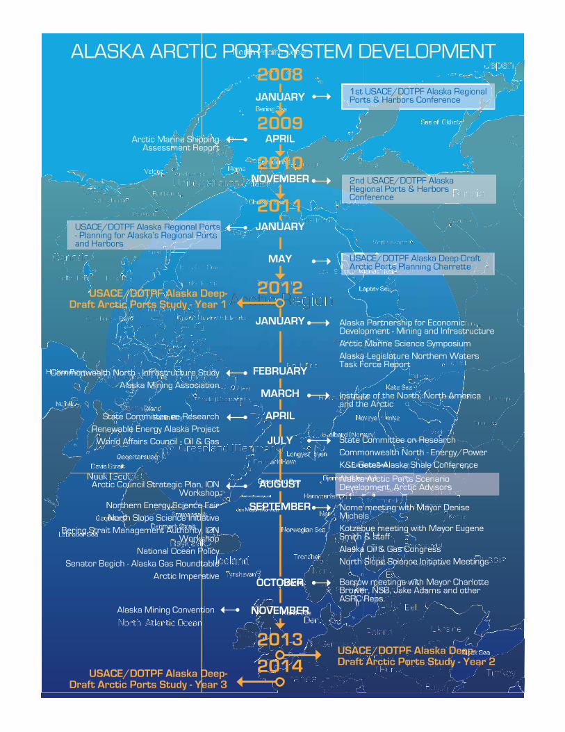
Alaska Partnership for Economic Development - Mining and Infrastructure Arctic Marine Science SymposiumAlaska Legislature Northern Waters Task Force Report
Commonwealth North - Infrastructure StudyAlaska Mining Association
Institute of the North, North America and the Arctic
State Committee on ResearchRenewable Energy Alaska Project
World Affairs Council - Oil & Gas State Committee on ResearchCommonwealth North - Energy/PowerK&L Gates Alaska Shale Conference
Arctic Council Strategic Plan, ION Workshop
Northern Energy Science FairNorth Slope Science Initiative
Bering Strait Management Authority, ION Workshop
National Ocean PolicySenator Begich - Alaska Gas Roundtable
Arctic Imperative
Nome meeting with Mayor Denise MichelsKotzebue meeting with Mayor Eugene Smith & staffAlaska Oil & Gas CongressNorth Slope Science Initiative Meetings
Barrow meetings with Mayor Charlotte Brower, NSB, Jake Adams and other ASRC Reps.
Alaska Mining Convention
2012
2011
2010
2009
2008
JANUARY
FEBRUARY
MARCH
APRIL
JULY
AUGUST
SEPTEMBER
OCTOBER
NOVEMBER
JANUARY
MAY
1st USACE/DOTPF Alaska Regional Ports & Harbors Conference
Arctic Marine Shipping Assessment Report
2nd USACE/DOTPF Alaska Regional Ports & Harbors Conference
USACE/DOTPF Alaska Regional Ports - Planning for Alaska’s Regional Ports and Harbors
USACE/DOTPF Alaska Deep-Draft Arctic Ports Planning Charrette
USACE/DOTPF Alaska Deep-Draft Arctic Ports Study - Year 1
USACE/DOTPF Alaska Deep-Draft Arctic Ports Study - Year 2
2013
2014USACE/DOTPF Alaska Deep-Draft Arctic Ports Study - Year 3
JANUARY
APRIL
NOVEMBER
ALASKA ARCTIC PORT SYSTEM DEVELOPMENT
Alaska Arctic Ports Scenario Development, Arctic Advisors
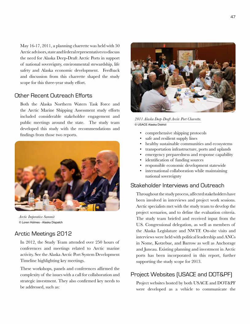
47
May 16-17, 2011, a planning charrette was held with 50 Arctic advisors, state and federal representatives to discuss the need for Alaska Deep-Draft Arctic Ports in support of national sovereignty, environmental stewardship, life safety and Alaska economic development. Feedback and discussion from this charrette shaped the study scope for this three-year study effort.
Other Recent Outreach Efforts Both the Alaska Northern Waters Task Force and the Arctic Marine Shipping Assessment study efforts included considerable stakeholder engagement and public meetings around the state. The study team developed this study with the recommendations and findings from those two reports.
Arctic Meetings 2012In 2012, the Study Team attended over 250 hours of conferences and meetings related to Arctic marine activity. See the Alaska Arctic Port System Development Timeline highlighting key meetings.
These workshops, panels and conferences affirmed the complexity of the issues with a call for collaboration and strategic investment. They also confirmed key needs to be addressed, such as:
• comprehensive shipping protocols• safe and resilient supply lines• healthy sustainable communities and ecosystems • transportation infrastructure, ports and uplands • emergency preparedness and response capability• identification of funding sources• responsible economic development statewide• international collaboration while maintaining
national sovereignty
Stakeholder Interviews and OutreachThroughout the study process, affected stakeholders have been involved in interviews and project work sessions. Arctic specialists met with the study team to develop the project scenarios, and to define the evaluation criteria. The study team briefed and received input from the U.S. Congressional delegation, as well as members of the Alaska Legislature and NWTF. On-site visits and interviews were held with political leadership and ANCs in Nome, Kotzebue, and Barrow as well as Anchorage and Juneau. Existing planning and investment in Arctic ports has been incorporated in this report, further supporting the study scope for 2013.
Project Websites (USACE and DOT&PF) Project websites hosted by both USACE and DOT&PF were developed as a vehicle to communicate the
Arctic Imperative Summit © Loren Holmes - Alaska Dispatch
2011 Alaska Deep-Draft Arcitc Port Charrette.© USACE Alaska District

48 Alaska Deep-Draft Arctic Port System Study
background and purpose for this study as well as to distribute drafts of the study sections for stakeholder review and comment. Comments received have been incorporated into the Draft Report. Below are the links to the sponsoring project websites for this study effort.
www.poa.usace.army.mil/Library/ReportsandStudies/AlaskaRegionalPortsStudy.aspx
www.dot.state.ak.us/stwddes/desports/arctic.shtml
Review by Affected Stakeholders and the Public
In late January 2013, this Draft Report was posted on the project websites with USACE and DOT&PF. Announcement of the availability of the document and 30-day comment period was emailed directly to over 2,000 stakeholders interested in Arctic policy and investment. This mailing included the membership of Institute of the North, and the Alaska Partnership for Economic Development, as well as the mailing list of interested parties involved in study interviews and work sessions, the updated tribal and ANC lists of DCCED/DCRA, the leadership of communities in the NSB and NWAB, and all the participants from the 2008 and 2010 conferences. A press release was issued to announce the public online access and invitation to comment.
Each of the comments received during this period is included in Appendix A-6. Comments will be considered in light of the next phases of feasibility development and any future studies.
Arctic Imperative Summit © Loren Holms - Alaska Dispatch
Week of the Arctic, August 2012© Oscar Avellaneda-Cruz
Week of the Arctic, August 2012© Oscar Avellaneda-Cruz

49
PUBLIC/PRIVATE PARTNERSHIP AND PORT AUTHORITIESThe Alaska Regional Ports project is a collaborative effort between the ADOT&PF and the USACE.
The challenges for the state, the nation, and our international concerns are located in the middle of the most remote areas of the country. Alaska’s Lieutenant Governor, Mead Treadwell, recently spoke at an Arctic Council gathering and was quoted as saying “We feel a bit naked when it comes to shipping…” 10
Admiral Robert J. Papp Jr. of the U.S. Coast Guard wrote, “Although the Coast Guard has operated in southern Alaska, the Gulf of Alaska, and Bering Sea for much of our history, in the higher latitudes we have little infrastructure and limited operating experience…”11 The State of Alaska is exploring ways to address the deep-draft port needs for the western and northern shores of the state. The constraints of developing Arctic ports and infrastructure and the complexity of multiple agency needs exceeds the capacity of any one party to underwrite. This chapter explores ways in which a public-private partnership (P3) could be pursued to meet the needs of the state while being proactive in protecting national sovereignty and the environment.
10 USACE/DOT&PF Alaska Deep-Draft Arctic Ports Planning Charrette, Anchorage, Alaska May 16-17, 2011 facilitated and summarized by ARCADIS.
11 Published on U.S. Naval Institute (http://www.usni.org) , created 2012-01-31 11:41

50 Alaska Deep-Draft Arctic Port System Study
P3 DefinedPublic-Private Partnerships, often referred to as P3, describe a government service or private business venture that is delivered through a partnership of government and one or more private sector companies.12 Depending on the circumstances, these partnerships can take many forms, all of which are developed based on the project and the relationships the parties are willing to enter. These are common practice in some countries (e.g., Canada13) and have a basis in this country as well. One of the earliest examples of P3 was the Lancaster Turnpike, a toll road built by the private sector with public sector oversight and rights-of-way, connecting Pennsylvania farmers with the Philadelphia market in 1793.14 The National Council on Public-Private Partnerships (NCPPP) and the Federal Highway Administration (FHWA) have defined P3s more specifically for their organizations.
National Council on Public-Private Partnerships (NCPPP) definition:
“A contractual agreement between a public agency (federal, state or local) and a private sector entity. Through this agreement, the skills and assets of each sector (public and private) are shared in delivering a service or facility for the use of the general public. In addition to the sharing of resources, each party shares in the risks and rewards potential in the delivery of the service and/or facility.” 15
“Public private partnerships are an important option that can be utilized in times of economic uncertainty and in periods of prosperity. There is a nexus between the public sector’s needs and the private sector’s goals. Local and state governments, particularly in today’s
12 Wikipedia, the Free Encyclopedia - http://en.wikipedia.org/wiki/Public%E2%80%93private_partnership
13 “In fact, the Province’s capital policy requires that a public-private partnership must be considered the base case procurement option where the provincial contribution to the capital cost exceeds $50 million.” Remarks from Hon. Colin Hansen – Minister of Finance and Deputy Premier, Province of British Columbia at the 17th Annual CCP3 National Conference on Public-Private Partnerships, December 3, 2009.
14 Ten Principles for Successful Public/Private Partnerships published by Urban land Institute, 2005.
15 The National Council on Public Private Partnerships -http://www.ncppp.org/
Week of the Arctic, August 2012© Oscar Avellaneda-Cruz
Week of the Arctic, August 2012© Oscar Avellaneda-Cruz
Arctic Imperative Summit © Loren Holms - Alaska Dispatch

51
challenging economic times, need to find innovative ways to improve infrastructure that makes sense to the taxpayer.”
– Doug Domenech, Secretary of Natural Resource of the Commonwealth of Virginia 16
Federal Highway Administration (FHWA) definition:
“A public-private partnership is a contractual agreement formed between public and private sector partners, which allow more private sector participation than is traditional. The agreements usually involve a government agency contracting with a private company to renovate, construct, operate, maintain, and/or manage a facility or system.”17
“FHWA encourages the consideration of public-private partnerships (P3s) in the development of transportation improvements. Early involvement of the private sector can bring creativity, efficiency, and capital to address complex transportation problems facing State and local governments. The Office of Innovative Program Delivery (IPD) provides information and expertise in the use of different P3 approaches, and assistance in using tools including the SEP-1518 program, private activity bonds (PABs), and the Transportation Infrastructure Finance and Innovation Act (TIFIA) Federal credit program to facilitate P3 projects.” 19
The following outlines the risks and rewards that could be achieved with the creation of Public-Private Partnerships to address the growing navigation, resource development, and related infrastructure needs of the Arctic.
Benefits of P3sPublic sector budgets are much more challenging than in the past. Public-Private Partnerships are an avenue to pursue that will enable the most efficient use of public
16 Ibid
17 The Federal Highway Administration - http://www.fhwa.dot.gov/
18 SEP-15 is a new experimental process for FHWA to identify, for trial evaluation, new public-private partnership approaches to project delivery. It is anticipated that these new approaches will allow the efficient delivery of transportation projects without impairing FHWA’s ability to carry out its stewardship responsibilities to protect both the environment and American taxpayers.
19 The Federal Highway Administration - http://www.fhwa.dot.gov/
and private resources in the pursuit of mutual gains. P3s make possible the completion of projects that would be impossible using more traditional methods of economic development.20
Possible benefits include:
• Shared vision: The vision is the framework for the project goals.
• Shared risks: Success or failure of the project does not fall to one entity.
• Improved project completion: International experience with P3s suggest that these arrangements are constructed within budget and on time more often than typical public construction. By maximizing each sector’s strengths, improvements in the number and quality of projects can be realized. Alternate delivery options allow more flexibility to achieve mutual goals and can minimize risk of cost overruns and schedule delays.
• Public has more access: The P3 must be transparent in order to succeed. All parties are held accountable to the public interests. This can also result in improved environmental compliance.
• Increased funding options: The combination of public and private financing provides more opportunity for funding and reduces the public capital investment.
• Mutual rewards: Outcomes include profitability for the private investor and increased delivery of basic infrastructure for the public sector.
• Job creation: Economic development projects will result in jobs for construction and ongoing operations.
20 Richard Norment, Executive Director for the National Council for Public-Private Partnerships. www.ncppp.org.

52 Alaska Deep-Draft Arctic Port System Study
Drawbacks/Risks of P3sAn arrangement such as the public-private partnership is not without its drawbacks. Following are some of the potential risks:
• Conflict of interest: The real or perceived conflict of interest is one of the greatest challenges of P3s.
• Maintenance of transparency: It is difficult to do business and maintain transparency that will suit all inquiring minds.
• Financial agreements: The more sophisticated the financing, the more potential for things to go wrong. Risk should be carefully weighed prior to entering into an agreement, especially if there are funding contingencies or foreign funds. There are many forms of partnership, allocating risks and rewards to each party. See Appendix A-5 for a description of the range of forms.
• Cost: Capital obtained through P3s can be more expensive than public capital.
• Control: Government will have to cede control of the aspects of the project for which users and citizens still hold government accountable. The biggest example is toll rates. Government is also held accountable by the public if it turns out that the private sector partner has made a windfall profit on the deal.
• Liability issue: The partnership agreements must clearly spell out who is responsible for each of the pieces and parts of the project, even while not knowing what the future brings. If the private investor is unable to meet the terms of the contract, the public entity must be able to take on the project alone or have another investor to fall back on. Consideration of insufficient revenues, bankruptcy, and default by parties should be spelled out in the agreement.
• Force majeure: It is important to remember that force majeure (major force) clauses are intended to excuse a party only if the failure to perform could not be avoided by the exercise of due care by that
party. The clause must apply to all parties of the P3 agreement as it does in standard engineering and construction contracts. This generally applies to things such as wars, natural disasters, and other major events that are clearly outside a party’s control.
• Labor concerns: Finding qualified workers is often a challenge for Alaska projects. The private investor may be accustomed to finding workers nationwide while the state government might give preference to hiring Alaska residents over other U.S. citizens. Resolving these concerns early in the negotiation is paramount.
• Capability: As in all agreements, the capacity and assets of all parties should be carefully evaluated. Competition should be designed to bring the best and brightest to the table. Often a Request for Qualifications (RFQ) will draw out the strengths and weaknesses of interested parties. A P3 agreement can include a performance bond.
Successful P3 Creation7 Keys to Successful P3s from the National Council on Public-Private Partnerships21
The following are considered “best practices” in the development of Public-Private Partnerships (P3s). It is recognized that the methodology for implementation of P3s can vary, depending on the nature of a given project and local concerns.
1. Public Sector Champion: Recognized public figures should serve as the spokespersons and advocates for the project and the use of a P3. Well-informed champions can play a critical role in minimizing misperceptions about the value to the public of an effectively developed P3.
2. Statutory Environment: There should be a statutory foundation for the implementation of each partnership. Transparency and a competitive
21 http://www.ncppp.org/howpart/index.shtml#keys

53
proposal process should be delineated in this statute. However, unsolicited proposals can be a positive catalyst for initiating creative, innovative approaches to addressing specific public sector needs.
3. Public Sector’s Organized Structure: The public sector should have a dedicated team for P3 projects or programs. This unit should be involved from conceptualization to negotiation, through final monitoring of the execution of the partnership. This unit should develop Requests For Proposals (RFPs) that include performance goals, not design specifications. Consideration of proposals should be based on best value, not lowest prices. The principal key to success: a business case that demonstrates the
P3 provides good value for money relative to the public sector alternative. Without that, there is no basis for a deal.
4. Detailed Contract (Business Plan): A P3 is a contractual relationship between the public and private sectors for the execution of a project or service. This contract should include a detailed description of the responsibilities, risks and benefits of both the public and private partners. Such an agreement will increase the probability of success of the partnership. Realizing that all contingencies cannot be foreseen, a good contract will include a clearly defined method of dispute resolution.
Image courtesy USCG visual information gallery

54 Alaska Deep-Draft Arctic Port System Study
5. Clearly Defined Revenue Stream: While the private partner may provide a portion or all of the funding for capital improvements, there must be an identifiable revenue stream sufficient to retire this investment and provide an acceptable rate of return over the term of the partnership. The income stream can be generated by a variety and combination of sources (fees, tolls, availability payments, shadow tolls, tax increment financing, commercial use of underutilized assets or a wide range of additional options), but must be reasonably assured for the length of the partnership’s investment period.
6. Stakeholder Support: More people will be affected by a partnership than just the public officials and the private sector partner. Affected employees, the portions of the public receiving the service, the press, labor unions, and relevant interest groups will all have opinions, and may have misconceptions about a partnership and its value to the public. It is important to communicate openly and candidly with these stakeholders to minimize
potential resistance to establishing a partnership. A key issue is the treatment of successor rights under existing collective bargaining agreements.
7. Pick Your Partner Carefully: The “best value” (not always lowest price) in a partnership is critical in maintaining the long-term relationship that is central to a successful partnership. A candidate’s experience in the specific area of partnerships being considered is an important factor in identifying the right partner. Equally, the financial capacity of the private partner should be considered in the final selection process.
Port P3 StructuresWhen a public port authority leases land to a terminal operator and allows that operator to construct and operate a terminal, that is a P3. This is a very common model for ports. Continued research (see Bibliography for references to Engel et al (2004); Juan et al (2004); Notteboom (2007); Pallis, Notteboom & DeLangen
Imag
e co
urte
sy U
SCG
vis
ual i
nfor
mat
ion
galle
ry

55
(2008); Theys, Notteboom, Pallis & DeLangen (2009) and Ferrari & Basta (2009) has focused on the structuring of concessions internationally. The majority of this work is focused on container terminals as opposed to whole ports. Some P3s are designed for captive user bulk terminals linked to vertically integrated supply chains. Generally, government is reluctant to let go of ports, viewed as strategic assets and/or cash cows. The landlord port structure which sits above the terminal P3s allows private sector efficiency and investment to be combined with continuing public sector control and a regular income flow.
Dr. Sheila Farrell presented to the Lisbon Symposium of PORTeC in 2011, on “Decision Models and P3 Performance in the Ports Sector.” She noted that ports were candidates for P3s because of sharing of infrastructure, regulation of monopolies, securitization of revenues and promotion/control of externalities. Most P3s in the ports sector take the form of landlord port authorities controlling privately-operated terminals. The role of the port authority is to provide and manage common facilities like the breakwater and entrance channel, utilities and road and rail access; to regulate the individual P3s; and to plan and implement the expansion and development of the port. The duration of the agreements is commonly 20-30 years.
There are four primary models for port P3s:
1. Divestiture of public assets where assets are leased to private operator for management/investment.
2. Development rights for private assets where assets are built and operated by private sector, and then transferred back at the end of the concession.
3. Joint ventures where the port has a large share in the terminal operating company as well as acting as landlord and regulator.
4. A public port authority investing in a private port.
P3s are now the dominant organizational structure for container terminals. Challenges with this form of port development and operation include competition, conflicts of interest, financial weakness of some landlord ports, and culture change. Management contracts, where the private sector operates port facilities on behalf of the public sector with minimal investment of its own are now quite rare. This is partly because they generate small returns in relation to the management time required. There is also a history of failure caused by conflicts over strategy, arising when private operators are not given the freedom they need to satisfy public sector objectives for the contract. Short term leases of public assets of up to 15 years, often renewable, are more popular than management contracts because they give the operator greater commercial freedom.
Most port P3s impose strict limits on what private operators are allowed to do, in terms of the types of cargo they are allowed to handle. Intended to encourage efficiency through specialization, this also protects the interests of other private operators and maximizes the value which the port authority can extract through the creation of local monopolies.
Two other common limitations on P3 activities are the separation of cargo handling from marine services, and the design of P3s on a terminal rather than a whole port basis. Cargo handling has traditionally been separated from marine services (pilotage and towage). The latter enjoy significant economies of scale. Safety and security have led to the desire to keep marine services in the public sector or outsource them to a single operator of good reputation. The level of specialization found in ports is not replicated in other modes of transport, and is one of the reasons why ports have entered into P3s on a terminal rather than a whole port basis.

56 Alaska Deep-Draft Arctic Port System Study
Four areas of future research noted in the literature are:
1. The gap between public sector objectives and public sector behavior
2. Exploring acceptable risk-reward ratios
3. The performance of different types of private partner
4. The impact of P3s on supply chain rents
Alaska P3 ProjectsThe State of Alaska has a history of P3 for infrastructure development, including KABATA and AIDEA, as well as the Valdez Port Authority.
Knik Arm Bridge and Toll Authority (KABATA)
The Knik Arm Crossing is a planned toll bridge and associated roadway crossing Cook Inlet between Anchorage – Alaska’s largest city – and the Matanuska-Susitna Borough – one of the fastest growing areas in the U.S. The Alaska Legislature established the Knik Arm Bridge and Toll Authority in 2003 under Alaska Statute 19.75 to “develop, stimulate, and advance the economic welfare of the state and further the development of public transportation systems in the vicinity of Upper Cook Inlet with construction of a bridge to span Knik Arm and connect the Municipality of Anchorage and the Matanuska-Susitna Borough.” (See Appendix for enabling legislation.)22
In 2007, Knik Arm Bridge officials planned to develop the bridge using a “revenue risk transfer” model, which had the potential of funding the project solely with private debt and equity. However, the 2008 financial crisis changed the marketplace significantly and it became clear that some collateral would be necessary to leverage the private equity necessary to build the bridge.
KABATA financial analysis shows that a project reserve, much like the project reserve used for the
22 Additional information about the Knik Arm Crossing Project and KABATA can be found on KABATA’s website at www.knikarmbridge.com.
© Joseph A Davis, ConsultNorth

57
Alaska Industrial Development and Export Authority (AIDEA) and Alaska’s Student Loan program, would allow the State to attract large amounts of private equity to build the bridge at attractive rates. The 2012 Alaska Legislature is deliberating on provision of this project reserve. There are three international consortia shortlisted as potential P3 candidates, with proposals to be solicited in fall 2012.
Revenue forecasts indicate that the requested project reserve will be sufficient to carry the project through traffic ramp up and that it will be repaid in full, generating about $1 billion more for the State than will be required to pay the private partner over the 35-year term of the agreement. The project reserve fund will be made whole once toll revenue is substantial enough to replenish the reserve fund, about seven years after bridge opening. When sufficient surplus beyond reserve requirements is generated, the State will be repaid its investment.
One of the primary reasons for the public sector to enter into a public-private partnership is to transfer risks to the private sector. In this case, the private sector partner will take on the risk of financing, designing, constructing, operating and maintaining the bridge over the term of the agreement. If the private partner underperforms or underestimates its costs, their profits will be impacted and they could lose their equity investment. Meanwhile, the State owns the bridge and the toll revenues from the day it is opened.
Valdez Port Authority
In 1999, Valdez residents voted to form the Alaska Gasline Port Authority. Since the Port Authority’s formation much has happened in the world energy markets to confirm moving Alaska’s vast resources of natural gas from the North Slope to Alaskans as cheap energy, anchored in long term contracts with the world markets, in the form of liquefied natural gas (LNG). The Port Authority continues to work closely with recognized energy leaders such as Sempra Energy
and Mitsubishi Corporation. The recent devastating earthquake in Japan has refocused Japan on their need for significant additional volumes of LNG imported from outside their country. Given Alaska’s 40+ years of supplying LNG to Japan, Alaska is an excellent position to fill that additional demand.
Alaska Industrial Development and Export Authority (AIDEA)
AIDEA is a public corporation of the State of Alaska, created in 1967 by the Legislature to “promote, develop and advance the general prosperity and economic welfare.”23
AIDEA has supported Alaska mining and ports for over 25 years. AIDEA’s functions include long-term planning, permitting for private development, feasibility studies, and capitalizing construction. Following are examples of previous AIDEA efforts:
• In 1985, AIDEA financed and built the first phase of the DeLong Mountain Transportation System, the road and port serving the area that includes the Red Dog Mine. DMTS is a 52-mile long, 30-foot wide industrial haul road and shallow-draft port with upland support facilities. AIDEA is repaid through user fees. In 1997, AIDEA financed the Production Rate Increase expansion of the DMTS Portside, to be repaid by user fees. In 2004, AIDEA participated in feasibility and environmental study of the proposed Terminal deep-water expansion to the DMTS Port.
• In 1990, AIDEA purchased and renovated the Skagway Ore Terminal. The Concentrate Storage Building was later demolished due to corrosion.
• AIDEA contracted and managed preparation of the Northwest Alaska Resource Development Transportation Study. In 1993, AIDEA (with repayment provisions through a Reimbursement Agreement) financed the scoping study of overland transportation options for the proposed Illinois Creek gold mine.
23 Alaska Statute 44.88 and Regulations 34AC 99.100.930

58 Alaska Deep-Draft Arctic Port System Study
• AIDEA also coordinated an economics study of the costs of exporting Healy coal to South Korea.
• In 1995, AIDEA entered into agreement with Suneel Alaska to purchase 49% of the Seward Coal Terminal. AIDEA was repaid through semi-annual payments.
• In 1996, AIDEA arranged federal permits enabling military craft to airlift mining equipment to the Illinois Creek mine site.
• In 1996, AIDEA issued conduit revenue bonds to finance the tailings facility at Fort Knox.
• AIDEA was authorized by the Legislature to issue conduit revenue bonds for docking facilities and tailings management facility at Kensington Mine. Staff undertook feasibility activities with repayment of costs by Coeur d’Alene Mines Corporation.
• AIDEA facilitated the study of power options to serve the potential Donlin Creek mine.
• AIDEA funded a feasibility study with Cash Minerals for shipping coal through the Skagway Ore Terminal.
• In 2007, AIDEA executed a 7-year user agreement with Sherwood and began construction of new Concentrate Storage Building and support structures in Skagway. The Ore Terminal was
reactivated. In 2010, a report for safe handling of lead concentrate was completed. Additional shippers of lead zinc may include Canadian firms and Selwyn Chihong Mining Ltd.
• AIDEA authorized a Reimbursement Agreement with Zazu Metals Corporation for AIDEA to conduct early due diligence on development of the Lik Deposit at DeLong Mountains. AIDEA brought in Behre Dolbear to perform the work.
Alaska Department of Transportation and Public Facilities (DOT&PF)
Similar to AIDEA, DOT&PF has the ability to fund port facility projects. Per Alaska Statute AS 30.15, the department is authorized to issue grants for a port or ferry terminal project through a bond or state appropriation as long as the project meets three tests:
• The Commissioner determines that the project is feasible.
• A municipality, which would include all the state boroughs, has passed a resolution of financial support to construct and maintain the port facility.
• The municipality can demonstrate its ability to finance the local share of the project costs. The local match varies with population size, from a minimum of 10 percent for a community under 5,000 people to 20 percent for a municipality with a population over 5,000.
AS 30.15 demonstrates port infrastructure projects at the state level. The requirement for a local match highlights the idea that there is a mutual benefit, and therefore a shared cost, between state and local governments in regards to port projects. Although DOT&PF has not exercised this authority in several decades since the creation of AIDEA, this statute could become attractive for future local, regional, or state port facility development and construction projects involving DOT&PF and public partners such as a municipality or a borough.
Image courtesy USCG visual information gallery

59
P3 Private PartnersThere is a broad range of private entities involved in P3 relationships for ports. Some of them could be potential partners for Arctic ports in Alaska.
Private partner candidates now involved in P3 relationships:
• Mining firms
• Oil and Gas firms
• Financial firms: Goldman Sachs; Guggenheim Partners; Deutsche Bank; AIG; Macquarie; Mantauban SA; Babcock & Brown Infrastructure
• Private foundations, retirement/pension funds: Ontario Teachers Pension Fund; Prudential; Borealis (Canadian pension fund)
• Sovereign funds: GIC (Singapore Gov Co); Dubai Ports World
• Port and shipping industry: CMA-CGM; Eurogate Holding; Hesse Natie; Eurokai; Hutchison Port Holdings; PSA Corp; Maersk Line; Neptune Orient Lines; Nippon Yusen Kaisha; P&O
Roadmap for P3 GenerationWhat is needed to support a public/private partnership for Deep-Draft Arctic Ports System development? The following issues define an approach for use with ports and harbors, but are also relevant to infrastructure and inland transportation, both rail and road.
State Action Opportunities
• Policy framework rationale and mapping. Accelerate investment in the Alaska Statewide Digital Mapping Initiative with a focus on the coastal areas of Western Alaska. Alaska is the only state in the nation lacking current, accurate, high-resolution maps. This hampers economic growth and presents risks to public safety. Resource management and economic development require a strong mapping foundation; emergency preparedness and readiness for disaster recovery depend on accurate location information.
Imag
e co
urte
sy U
SCG
vis
ual i
nfor
mat
ion
galle
ry
60 Alaska Deep-Draft Arctic Port System Study
• Project development funds (State Infra-structure Banks, taxes, tolls, bonds). The state has a P3 coordinator at AIDEA. There needs to be continued recognition of the development and scale of the effort beyond standard civil pro-curement.
• Oversight of contract development, ongoing operations. This will include accountability for true costs, contingent liabilities, costs of central P3 agency resources, capacity building. It will require regular public reporting and a new level of responsibility. Much like when the Legislature created the KABATA Board with expertise, and the funds to hire consultant expertise.
• Roads to Resources. The State DOT&PF could accelerate its investment, planning and delivery of the Roads to Resources program to provide the necessary connectivity for successful Arctic ports development. Currently, the state has identified some candidate roads that would serve the economic development agenda. A system wide approach could be developed to document the necessary roads, costs and timeline to delivery. This effort would provide increased certainty for port and for resource development investment.
• Economic Research. The State could invest in resource economists and research within state agencies, and through contractors and the University of Alaska. The development of baseline data about resource development potential is critical to the formulation of sound projects and the ability to secure significant investment from other parties.
• Policy framework rationale and commitment. General support for P3 is present now with the State establishing a P3 office at AIDEA. Additional funding for AIDEA investment is under consideration in the 2013 legislative session. The priority of resource development and infrastructure in Alaska could be manifested in regulatory processing, specialized training of public sector professionals, training for Alaska workforce, investment in research, and support of the University.
• Legal framework. Underlying legislation was set up for KABATA. AIDEA legal structure and operating history is also in place. Alaska has the foundation to support P3 activity. Industrial roads by DOT&PF would require additional legislation.
• Human resources/expertise-skills develop-ment contracted or inside public sector is needed for identification, evaluation, and cultivation of P3 enabling transactions, maintaining oversight, sustaining talent and experience over time. Po-tential P3 partners for Arctic Ports include mining companies, investment firms, private foundations, retirement and pension funds, the Alaska Native Corporations, CDQ groups, the Alaska Railroad Corporation, shipping, and oil/gas companies. Note that 70 percent of the investment in Alaskan mining is from Canadian companies.24
• Procedures/guidelines to standardize con-tracts and procurement. It is important to educate and standardize to make this development approach more acceptable to decision makers, state and federal leaders, and predictable for private ventures.
• Organization to hold the development partnership function. AIDEA could be a consultant to the agencies, as to DOT&PF for Roads to Resources. DOT&PF would lead engineering and permitting, and AIDEA would be the investment arm. The state could step aside when the P3 agreements are in place and might handle only startup. The model might be parallel to the airport system, where the port and the uplands infrastructure are treated as one investment, with leased interests to private parties. The P3 might own and operate for a period of time. For inland transport (road and rail) it is important that agreements allow the facilities to be a catalyst for other development, rather than proprietary. See the port facilities at DMTS and Skagway for more details of how this is currently working.
24 Canada’s Impact on Alaska.” Consulate of Canada, Anchorage. Updated July 2009
61
• Information dissemination and public/private education could be enhanced.Develop database of Alaska models and globalmodels. Develop model contract language andterms. Develop the investment case to attractprivatepartners.
• Regional Port Authority.ThecoststodevelopArcticportsandappropriateinfrastructurewillbesignificant.Nosingleentity,communityorbusinesswouldbeabletofinanciallysupportandcarryfullrisks for this infrastructure. The facilities mustbe designed and developed to 1) accommodatemultipleuserswithmultipleinterestsand2)makesenseforaregionratherthanalocale.Differentmissionswill requiredifferentport infrastructure,andevendifferentsites.Amultipleportsystemislikely to be required. Some have suggested thata Port and Development Authority for Western
Alaska be considered, which would includeresponsibilityforportsdevelopmentandforrelatedinfrastructure.
Federal Action Opportunities
• Mapping. Develop NOAA’s ShoreZone coastalhabitat mapping for Western Alaska as it hasbeen for Prince William Sound and the Gulf of Alaska. This standardized system catalogsboth geomorphic and biological resources atmappingscalesof betterthan1:10,000.Thehighresolution,attributerichdatasetisausefultoolforextrapolationof sitedataoverbroadspatialrangesandcreatingavarietyof habitatmodels.
• P3Legislationthatwouldenablepublic-privatepartnerships for anArctic portwould be helpfulsothatvariousfundingagenciescancapitalizeonsharedresources.
Imag
e co
urte
sy U
SCG
vis
ual i
nfor
mat
ion
galle
ry

62 Alaska Deep-Draft Arctic Port System Study
• Finance.EnsureaccesstovariousFederalfundingstreams/ loans/ loan guarantees, includingthe Transportation Infrastructure Finance andInnovationActprogramwithintheUSDOT&PF.
• Tax Incentives. Resourceextractioncompaniescould be allowed a “tax holiday” in the initialyears of development for their participation inP3s so that importantcapital investmentscanbemadewhich encouragedevelopment rather thanpenalizeriskyinvestments.
• Regulatory. Provide guidance and authorityto define the lead agency, establish permitcoordination and timelines including support of agencyEIS,if appropriate.
• Support of Arctic Council. Support ArcticCouncilagendatonegotiateinternationalprotocolsfor Search andRescue,Oil SpillResponse,, andaddresstheneedsof indigenouspeople.
• Other Incentives. Authorize different Federalagencies tosharetheirresources forprojects thatprovide shared benefits. Both the Coast Guardand theNavy have expressed interest in using adeep-draft port in Alaska, yet neither can bringcapitalfundingtotheprojectfordevelopmentontheirown.Authorize longtermleasesbyFederalagenciesasawaytohelpfinanceportdevelopmentintheregion.
Private Sector Action Opportunities
The private sector is looking for certainty andpredictabilityinsupportof thelong-termrelationshipsneededforprojectdevelopmentandongoingoperations.Thecomponentsof agoodagreementinclude:
• Leadership. Private partner alignment withdesignated federal and state public sectorindividual or office in charge of championingtheserelationshipsandopportunities.
• Vision. Clearly articulated shared vision of thevalueof partnershipand itsdesiredoutcomesasthebasisof contractualagreements.
• Human capacity. Solid partners andprofessional management inside private partnerfirms and government to evaluate proposals;draft P3 contract; negotiate terms & conditions;manage design; oversee construction; coordinatetechnical,managementandfinancialresourcesfordevelopmentandoperations.
• Social responsibility.Alignmentof privateandpublicsectorsupportof stakeholders,includingendusers, communities,generalpublic, laborunions,competing interests, public sector employees.This could include private support of thought-leadershipandtrainingthroughtheUniversityof Alaskaandothertrainingorganizations.Excelatbeingagoodneighbor.
• Defined revenue stream. Funding to coverlong-termfinancingandcashflow.
• A real project with detailed business plan. Planandcontractsrespondingtogenuineneedinthemarket.Theprojectshouldincludeperformancegoal-orientation with space for innovation; cleardecision-makingprocess;bestvalueversus lowestprice; specificmilestones and goals; reporting of metrics and frequency; risk allocation strategy;dispute resolution methodology; workforcedevelopmentassumptionsandexpectations.

63
RECOMMENDATIONSThisDraftReportoutlines theworkandfindings for thefirstyearof athree-yearstudy.Recommendationsfromthisfirstyearsetthecoursetodefinethescopeforcontinuedworkin2013and2014.
• Invest strategically to enhance the Arctic PortsSystem.Includedeep-draft solutions forresourceexport and support, as well as improvementsappropriateforUSCG,environmentalprotection,SAR,andcommunityresupply.
• Assign lead Federal agency responsibility to theU.S. Army Corps of Engineers for permitting,design,andconstructionof theAlaskaDeep-DraftArcticPortsystem.
• Encourage private entities/banks and authorizepublic agencies to collaborate in funding andconstructing marine infrastructure. Use thestrengthsof eachentitytoachievesuccessthroughPublic/PrivatePartnerships(P3).
• IncreasefundingtoNOAAandotheragenciestoprovide hydrographic and bathymetric mappingandneededdatatosupportmarineinfrastructuredevelopment.
• Explore and develop navigational aids, such asshiprouting,vesseltracking,trafficseparation,andidentificationof areasof concern.
• Conduct feasibility analysis of shortlisted sites(NomeandPortClarence)usingphysicalcriteriaand alignment with potential investors; P3development;andPortmanagementauthority.
Theserecommendationsforfurtherstudyof theAlaskaDeep-Draft Arctic Port system reflect the policiesgoverning formulation of projects. They do notnecessarilyreflecttheprogramandbudgetingprioritiesinherentinthelocal/StateandFederalprogramsortheformulation of a nationalCivilWorkswater resourceprogram.Consequently,therecommendationsmaybechangedathigherreviewlevelsof thelocal/StateandFederalgovernment.

64 Alaska Deep-Draft Arctic Port System Study Nome, Alaska© Joseph A Davis, ConsultNorth

65
NEXT STEPS, 2013-2014 SCHEDULE The2013-2014nextstepsassumesthattheStateDOT&PFand USACE will continue to share the costs of thefeasibilitystudywhileotherspursueestablishmentof aportmanagementauthorityaswellaslookforP3opportunities.Additionally, these next steps assume that the two sites(NomeandPortClarence)will form the initial feasibilityevaluation to enhance the system of Alaska Deep-DraftArcticPorts.Stepsinclude:
• Secure commitment from the State and Federalgovernmenttoconductthestudy.
• Conduct planning study that includes acombinationof alternativesthatmeettheplanningobjectivesandconstraintsoutlinesinthisreport.
• Coordinate environmental research ensuringcompliance and identify mitigation concerns ateachof thesites.
• Collect wind, wave, ice, and soil sample data ateachof thesites.
• Investigate fleet characteristics requiring deep-draftnavigationcapability.
• Seekpublicinputonthealternativesconsidered.
• Investigaterealestateownership.
• Conducteconomicanalysistoidentifythebenefitsassociatedwiththeportsystem.
• Designengineeringsolutionsforeachof thesiteswiththeintentof capitalizeonthestrengthsandweaknesses of each in order to have a completesystem.
• Establishneedforuplandinfrastructure.
• Develop preliminary cost estimates for the finalarrayof alternatives.
• Continuetobealerttofactorsthatmayacceleratetheconsiderationof otherportlocationsthatdidnotappearduringthisstudy’sevaluation.

66 Alaska Deep-Draft Arctic Port System Study
Imag
e co
urte
sy U
SCG
vis
ual i
nfor
mat
ion
galle
ry

67
APPENDICES A–1 Ongoing Arctic Studies/Projects
A–2 Bibliography of Arctic Alaska Research
A–3 Alaska Marine Exchange Bering Strait Vessel Traffic Report, 2012
A–4 Multi-Criteria Decision Analysis
A–5 Public Private Partnership Examples
A–6 Public Comments
ALASKADEEP-DRAFT
ARCTICPORT SYSTEM STUDY
Graphic Design: Studio Graphics AK