carlisle city sfra main report - cumbria · figure a.13 – milbourne street breach analysis figure...
TRANSCRIPT

Carlisle SFRA Final Report
November 2011

Atkins Carlisle SFRA | Version 3.0 | 22 November 2011 2
Notice
This document and its contents have been prepared and are intended solely for Carlisle City Council‟s information and use in relation to Strategic Flood Risk Assessment for Carlisle City Council Boundary.
Atkins Limited assumes no responsibility to any other party in respect of or arising out of or in connection with this document and/or its contents.
Document History
Job number: 5099404 Document ref: 5099404/60/DG/001
Revision Purpose Description Originated Checked Reviewed Authorised Date
Rev 1.0 Draft Final Report EA SF MJ MJ March 2011
Rev 2.0 Final Report MP EA MJ MJ September 2011
Rev 3.0 Final Report with client additions
MP EA MJ MJ November 2011

Atkins Carlisle SFRA | Version 3.0 | 22 November 2011 3
Table of contents
Chapter Pages
1. Introduction 5 1.1. Overview 5 1.2. Future Development within Carlisle 5 1.3. Objectives 6 1.4. Scope of this Document 6
2. Review of Planning Policy 7 2.1. National Planning Policy 7 2.2. Local Planning Policy 8
3. Data Collection and Review 11 3.1. Introduction 11 3.2. Overview of the Carlisle Area 11 3.3. Flood Zone Definition 12 3.4. Hydraulic Modelling 13 3.5. Historical Flood Events 13 3.6. Recent Studies on Flood Risk 15 3.7. Existing Flood Defences 16 3.8. Flood Warning 19 3.9. Development Control 20 3.10. Potential Development Sites 20 3.11. Consultation 21
4. Flood Risk in Carlisle 22 4.1. Sources of Flooding 22 4.2. Flood Defences 27 4.3. Flood Risk Sensitivity 27
5. PPS 25 and the Sequential Test 33 5.1. Background 33 5.2. Sequential Test 33 5.3. Assessing Flood Risk Using the Sequential Test 34 5.4. Windfall Sites 39
6. Sustainable Flood Risk Management 40 6.1. Overview 40 6.2. Responsibility for Flood Risk Management 40 6.3. Strategic Flood Risk Management 41 6.4. Planning and Development Control 42 6.5. Mitigation Measures 43 6.6. Surface Water Management 46
7. Conclusions and Recommendations 50 7.1. Conclusions 50 7.2. Recommendations 51
Appendices
Appendix A. Figures Figure A.1 – Historical Flood Outlines Figure A.2 – Potential Development Sites Figure A.3 – Flood Zone Outlines Figure A.4 – Sewer Flood Risk Figure A.5 – Groundwater Flood Risk Figure A.6 – Reservoir Breach Flood Risk
Atkins Carlisle SFRA | Version 3.0 | 22 November 2011 4
Figure A.7 – Areas Susceptible to Surface Water Flood Risk Figure A.8 – Flood Map for Surface Water Figure A.9 – Flood Defences Figure A.10 – Climate Change Figure A.11 – Caldewgate/Shaddongate Breach Analysis Figure A.12 – Denton Holme Breach Analysis Figure A.13 – Milbourne Street Breach Analysis Figure A.14 – Rickergate Breach Analysis Figure A.15 – Willowholme Breach Analysis Figure A.16 – Sequential Test
Appendix B. Potential Development Sites
Appendix C. Flood Mapping Methodology
Appendix D. Breach Analysis Methdology
Appendix E. Flood Risk Vulnerability Classification to inform the Sequential Test
Appendix F. Planning Guidance
Appendix G. Guidance Notes for Developers
Tables Table 1-1 - Appropriate Development for each Flood Zone
Table 1-2 - Historical Flooding in Carlisle
Table 1-3- Raised Defences
Table 1-4 - Flood Hazard Classification (risks to people)
Table 1-5 - Summary of the Potential Development Sites and Flood Zones
Table 1-6 - Summary of the Potential Housing Development Sites where the Exception Test is Required
Table 1-7 - Summary of the Potential Housing Development Sites where Development is not Acceptable
Table 1-8 - Summary of the Potential Employment Development Sites where Development is not Acceptable
Table 1-9 - Summary of Mitigation Measures
Figures Figure 1.1- Sources of Flooding
Figure 1.2 - Risk Zone behind Flood Defences
Figure 1.3 - Flood Hazard from a Breach of Flood Defences
Figure 1.4 - Overtopping of Defences with Standard of Protection less than 1% AEP
Figure 1.5 - Flood Zones
Figure 1.6 - Flow Diagram of Sequential Test Methodology
Plates Plate 1 - Breaching of a Flood Defence Embankment
Atkins Carlisle SFRA | Version 3.0 | 22 November 2011 5
1. Introduction
1.1. Overview Carlisle City Council is a largely rural area with population concentrated in the principal settlement of Carlisle and a number of market towns (Brampton and Longtown) and villages including Wetheral, Warwick Bridge, Cumwhinton, and Scotby. Flooding is the most widespread and frequently occurring of natural hazards and, therefore, flood risk is one of many factors that should influence the spatial planning process. All forms of flooding and their impact on the natural and built environment are material planning considerations.
Carlisle City Council lies predominantly within the catchment of the River Eden but a small area within the northernmost part of the Council Boundary is within the River Esk catchment. It is important to recognise that the City of Carlisle is situated immediately downstream of the Eden District through which the River Eden flows before entering Carlisle. The northernmost part of the Carlisle City Council area is adjacent to Dumfries and Galloway Council through which the River Esk flows before entering Longtown. Any changes to development and flood management within these adjacent council areas need to be considered to ensure they do not affect the flood risk to proposed development within Carlisle City.
Planning Policy Statement 25: Development and Flood Risk (PPS25)1 states that a Strategic Flood Risk Assessment (SFRA) “should be carried out by the local planning authority to inform the preparation of its Local Development Documents, having regard to catchment-wide flooding issues which affect the area.” In October 2010 Atkins was commissioned by Carlisle City Council to develop a SFRA to inform the preparation of the Core Strategy. The preparation of the Core Strategy as part of the Local Development Framework for the City has commenced and a key aspect will be to provide a framework for the future direction of development within Carlisle and surrounding areas.
1.2. Future Development within Carlisle The City Council‟s Urban Design and Public Realm Framework created visions for different areas within Carlisle, including the Rickergate and Shaddongate areas. The Council is preparing a development brief for the Caldewgate/Shaddongate2 area which will build upon the Urban Design and Public Realm Framework Supplementary Planning Document (SPD)3. The SPD states that:
“Shaddongate/Caldewgate should be a place where people want to live and work. There will be a choice of housing, varying in price and tenure in new buildings, as well as in the historic ones. There will be business premises of varying size and type, from small workshops to offices. Shaddongate/Caldewgate will be a lively, but safe place in which to live and work. Various potential sites have been identified within the Site for possible new development. The key to regeneration of the area will be restoration and re-use of historic buildings together with good quality new development which respects the existing urban grain and street pattern”.
It is expected that a mixed commercial and retail/residential development should form the main phase of development on the site. Any such scheme should include a significant amount of high quality and high density residential accommodation, with supporting retail/leisure and community uses at ground floor level.
For the Rickergate area, the Urban Design and Public Realm Framework SPD provides a vision for the future, as follows:
“Transformational change in Rickergate will make this area of diverse architectural styles a vibrant and integral part of Carlisle City Council’s area. A diversification of uses and substantial redevelopment will enhance and rejuvenate the area. Existing buildings of outstanding quality will work with new development and public realm to create a distinct character and identity. The
1 Planning Policy Guidance Note 25: Development and Flood Risk. DETR, 2001.
2 Planning Brief for Shaddongate/Caldewgate: A Supplementary Planning Document. Carlisle City Council. Consultation Draft
May 2009. 3 Urban Design Guide and Public Realm Framework. Supplementary Planning Document. Carlisle City Council.

Atkins Carlisle SFRA | Version 3.0 | 22 November 2011 6
primary routes will become mixed use streets, providing activity and amenities for residents, workers and visitors to the City. Public art, signage and lighting to existing subways will create dynamic pedestrian links to surrounding areas, reuniting the City Centre with its adjacent communities. Spectacular views to the City and Bitt’s Park will be maximised with new public realm that embraces the green character on its fringes. Redevelopment of the area will include a new civic space at its heart that will become a focus for activity for the surrounding community and the City as a whole”.
The Denton Holme Supplementary Planning Document4 sets out the key character of the area and provides design principles to be applied for any future development. Mixed housing schemes are encouraged to provide for a range of needs.
1.3. Objectives The requirements for a Strategic Flood Risk Assessment are set out in PPS25 and a completed SFRA should:
Provide sufficient data and information to enable the LPA to apply the Sequential Test to land use allocations and, where necessary, the Exception Test
Enable the LPA to prepare appropriate policies for the management of flood risk within the Local Development Documents (LDDs)
Inform the Sustainability Appraisal so that flood risk is taken into account when considering options and preparing strategic land use policies
Identify the level of detail required for site-specific FRAs in particular locations, and
Enable LPAs to determine the acceptability of flood risk in relation to emergency planning capability.
1.4. Scope of this Document The Carlisle SFRA Report has been prepared in accordance with PPS25 to summarise the findings of the data collection phase and the undertaking of the Sequential Test in respect of potential development areas/sites identified so far throughout Carlisle as part of the emerging Core Strategy evidence base.
The report firstly provides an overview of the planning context in relation to flood risk and development within Carlisle (Section 2). A summary of the data collected and a review of this data is provided (Section 3) which then forms a basis for the assessment of flood risk in Carlisle (Section 4). The Sequential Test is outlined for each of the potential sites for development (Section 5). Sustainable flood risk management is discussed for future development in Carlisle (Section 6).
The Environment Agency regularly review and update, if necessary, their Flood Map as more detailed hydraulic modelling of rivers and mapping of flood risk is undertaken along with more recent historical events. This work will improve the quality of data available and the understanding of flood risk within the City. It may also result in changes to the predictions for flood levels and flood extents that may have to be taken into account in future decisions at development control level.
All SFRAs should be considered to be living documents, subject to regular review in response to changing policy requirements and improved understanding of flood risk in the areas to which they apply. This document presents the most recent update of the Carlisle City SFRA which was first published in August 2006 and incorporates information which has become available since its original publication.
4 Denton Holme and Longsowerby Design Statement. Supplementary Planning Document. Carlisle City Council. January
2007
Atkins Carlisle SFRA | Version 3.0 | 22 November 2011 7
2. Review of Planning Policy
This section provides an overview of the planning context in relation to flood risk and development within Carlisle.
2.1. National Planning Policy National Planning Policy plays a key role in shaping the direction in which the Local Planning Authorities (LPA) prepare their Local Development Frameworks (LDF). Planning Policy Statements set out the Government‟s national policies on different aspects of land use planning in England. The key Planning Policy Statement (PPS) which has been instrumental in bringing forward SFRAs is Planning Policy Statement 25: Development and Flood Risk (PPS25). Other key PPSs which have influenced the scope of this SFRA include PPS1
5, PPS3
6 and PPS47. The
key principles promoted by these PPSs are described in the following sections.
PPS1: Delivering Sustainable Development
PPS1 sets out the Government‟s aims and objectives for delivering sustainable development, for current and future generations. One of the key principles set out in PPS1 is to ensure that sustainability is considered for the life time of new development by taking due account of the physical environment and the impacts of climate change.
The key to delivering sustainable development is centred at the planning and design stages. PPS1 encourages LPAs to consider all aspects of the physical environment when identifying land for development. In particular, when preparing development plans, LPAs should identify the potential impacts that natural hazards may pose to new development and as far as possible, avoid development in areas at risk of flooding and sea level rise. Should development in areas of flood risk be required to meet the wider objectives of sustainable development, PPS1 supports the design of new development which accommodates natural hazards and the impacts of climate change to ensure the development is safe, sustainable, durable and adaptable.
PPS3: Housing
PPS3 sets out the national planning policy framework for delivering the Government‟s housing objectives. The policies set out in PPS3 should be taken into account by LPAs in the preparation of the Local Development Documents. PPS3 encourages LPAs to take account of the constraints of the physical environment and natural hazards, such as flooding, when identifying broad locations for housing development.
PPS3 also states that a key objective of the LPA should be to continue to make effective use of land by re-using land that has been previously developed. In addition the policy states that the national annual target is that at least 60% of new housing is provided on previously developed land. This includes land and buildings that are vacant or derelict as well as land that is currently in use but which has potential for re-development. However, the policy also recognises that LPAs will need to consider sustainability issues for some sites as they may not be suitable for housing. A key example of where sustainability of previously developed land may need further consideration is where land is vulnerable to flood risk.
PPS4: Sustainable Economic Growth
PPS4 sets out the national planning policy framework for delivering the Government‟s objective of sustainable economic growth. The policies set out in PPS4 should be taken into account by LPAs in the preparation of the Local Development Documents. LPAs are encouraged to take account of the constraints of the physical environment by steering development away from sites prone to flooding or coastal erosion.
5 Planning Policy Statement 1: Delivering Sustainable Development. Office of the Deputy Prime Minister (May 2006)
6 Planning Policy Statement 3: Housing. Department for Communities and Local Government (June 2010)
7 Planning Policy Statement 4: Planning for Sustainable Economic Growth, Department for Communities and Local
Government (December 2009)
Atkins Carlisle SFRA | Version 3.0 | 22 November 2011 8
PPS25: Development and Flood Risk
Planning Policy Statement 25: Development and Flood Risk (PPS25) complements other national planning policies and should be read in conjunction with Government policies for flood risk and water management, including Making Space for Water, The Water Framework Directive and the Water Management Act. The aims of PPS25 are to ensure that flood risk is taken into account at all stages of the planning process to avoid inappropriate development in areas at risk of flooding and to direct development away from areas at highest risk (the Sequential Test). If, exceptionally, new development is necessary in such areas the policy aims to make the development safe without increasing flood risk elsewhere and, where possible, reducing flood risk overall (the Exception Test).
PPS25 requires an assessment of flood risk to be carried out to an appropriate degree at all levels of the planning process viz:-
a Strategic Flood Risk Assessment (SFRA) to inform the Local Development Documents (LDDs);
a site-specific Flood Risk Assessment (FRA) to be submitted with planning applications for development in areas of flood risk, under the circumstances identified in the PPS;
LPAs are required under PPS25 to prepare and to implement planning strategies that help deliver sustainable development. In developing their policies and strategies, LPAs should work with the Environment Agency and other relevant operating authorities and stakeholders in appraising, managing and reducing flood risk. As part of this process, LPAs should prepare Strategic Flood Risk Assessments (SFRAs) as freestanding assessments to contribute to the Sustainability Appraisal of their plans.
2.2. Local Planning Policy
2.2.1. Carlisle District Local Plan The City Council adopted the Carlisle District Local Plan 2001-2016 at its meeting on the 9th
September 2008. The Local Plan sets out the policies and proposals for future development and land use within Carlisle and is a "saved plan" under the provisions of the Planning and Compulsory Purchase Act 2004.
Amongst these policies saved the following are of relevance in respect of flooding matters.
POLICY CP10 Sustainable Drainage Systems
Sustainable Drainage Systems (SUDS) should be incorporated into development proposals when the following conditions apply: 1. The development will generate an increase in surface water run-off; and 2. The rate of surface water run-off is likely to create or exacerbate flooding problems.
Where SUDS are incorporated the following details shall be provided: 1. The type of SUDS; and 2. Hydraulic design details/calculations; and 3. Pollution prevention and water quality treatment measures together with details of pollutant
removal capacity; and 4. Operation, maintenance and adoption details (SUDS structures will not be adopted by the
statutory sewerage undertaker unless maintenance and legal agreements are in place).
POLICY LE26 Undeveloped Land in Floodplains
Development in areas at risk of flooding on undeveloped land will only be permitted where a Flood Risk Assessment has been submitted with a planning application that confirms: 1. no other lower risk alternative site exists; and 2. flood defences provide an acceptable standard of protection; and 3. access and egress can reasonably be maintained at times of flood risk; and 4. adequate floodplain storage capacity can be provided; and
Atkins Carlisle SFRA | Version 3.0 | 22 November 2011 9
5. the development will not interfere with flood flows; and 6. mitigation measures will be provided where necessary; and 7. the development will not increase flood risk elsewhere.
POLICY LE27 Developed Land in Floodplains
Development on previously developed land which is at risk of flooding will only be permitted provided that a Flood Risk Assessment has been submitted with the planning application that confirms: 1. no other lower risk alternative site exists in the case of proposed development in Zone 3
(High Probability of river and/or sea flooding); and 2. flood defence measures to the appropriate standard are already in place or can be provided;
and 3. adequate flood plain storage capacity can be provided; and 4. the development will not interfere with flood flows nor increase flood risk elsewhere; and 5. access and egress could be reasonably maintained at times of flood risk; and 6. adequate flood warning and evacuation procedures will be provided; and 7. mitigation measures will be provided where necessary; and 8. the building materials are appropriate for a flood risk area.
POLICY LE28 Undeveloped Coastal Zone
Development will only be permitted on the undeveloped coast if it cannot reasonably be located elsewhere, does not increase the risk of flooding or coastal erosion, and meets one of the following criteria:
1. It must be essential for coastal protection; or 2. It is essential for marine navigation; or 3. It conserves or enhances the quality and landscape character of the coastal zone.
2.2.2. Carlisle Local Development Framework The LDF will be a key component in the delivery of the Carlisle Community Strategy Plan entitled: Carlisle Partnership Community Plan (2011 – 2016). The various components of the LDF, known as Local Development Documents (LDDs) will express the elements of the strategy which relate to the development and use of land. LDDs include Development Plan Documents (DPDs) that are geographical or issue specific and Supplementary Planning Documents (SPDs) that detail core policy issues contained within the DPDs, so they can be interpreted and implemented. Both types of document can be prepared and updated separately and are subject to rigorous procedures of community involvement.
The Core Strategy DPD is central to the future development of the District and will be the first DPD to be prepared. The Core Strategy will set out the key elements of the City Council‟s planning policy framework up to 2030, setting out the long term spatial vision for the District, the strategic objectives, spatial strategy and core development management policies. The Core Strategy will indicate in broad terms what development will be delivered in the District over the period to 2030, when it will be delivered and how it will be delivered through both the Strategy and other related DPDs, as well as through programmes within and outside the LDF.
The Allocations of Land DPD must be in conformity with the Core Strategy and will identify site-specific allocations for particular uses in Carlisle necessary to deliver the spatial vision set out in the Core Strategy. Sites will be identified in accordance with the policies in the Core Strategy and relevant national guidance.
The Planning and Compulsory Purchase Act 2004 requires Carlisle City Council to prepare and maintain a document known as the Local Development Scheme (LDS). The LDS is a public document, setting out the City Council‟s programme for preparing various aspects of the LDF over the next three years. The LDS has three main purposes: -
Atkins Carlisle SFRA | Version 3.0 | 22 November 2011 10
To inform the public of the development plan documents that will make up the new planning policy framework;
To set out the timescales the public can expect for the preparation and review of these documents. The timetable specifically includes consultation milestones to inform the public about opportunities to get involved with the plan making process and to let them know the likely dates for involvement; and
To establish and reflect City Council priorities and to enable work programmes to be set for the preparation of development plan documents.

Atkins Carlisle SFRA | Version 3.0 | 22 November 2011 11
3. Data Collection and Review
3.1. Introduction The purpose of the data collection and review phase of the SFRA is to identify and obtain information regarding flood risk. It is during this phase that existing knowledge is collated with regards to the sources and extent of flood risk; existing flood management measures; and the land use and development opportunities within the Carlisle City area.
Consultations have been undertaken with Carlisle City Council, Cumbria County Council, the Environment Agency, United Utilities and neighbouring authorities.
The information gathered during this phase has been used to assess the potential extent and frequency of flood risk, the implications of this flood risk for development opportunities and the opportunities for flood management practices which may help mitigate or reduce future flood risk.
3.2. Overview of the Carlisle Area Carlisle City is the most northerly district within the County of Cumbria bordering Scotland and covers an area of approximately 400 square miles. The population of the area is approximately 105,0008 with 75% of these inhabiting the city of Carlisle.
Carlisle City Council area predominantly lies within the Eden catchment but a small area within the northernmost part of the Council boundary is within the River Esk catchment. Within any catchment the hydrology is intrinsically linked to the geology and topography. The geology of the Carlisle City Council area is dominated by sandstone and mudstones to the western side of the Eden and Limestone of the Carboniferous series to the east and around Carlisle, forming an extensive outcrop. The impermeable nature of the sandstones promotes rapid run-off and short response times for peak flows to occur on the River Eden. The area downstream of and to the west of Carlisle is of low relief and underlain by mudstone of the Mercia, Permo-Triassic and Lias, Jurassic ages. Both are considered to be non-aquifers. The geology and hydrogeology of the catchment combines with the topography resulting in rivers with water levels that rise quickly after rainfall. A short response to rainfall leads to a rapid increase in river levels.
Alluvium is found immediately adjacent to the Rivers Eden, Caldew and Irthing and it is extensive in the area around Carlisle. Peat occurs in the north east of the catchment generally below 200-300m. Peat reduces the effects of rainfall, retaining moisture and continues to release runoff sometime after rainfall. However, if waterlogged it may act as a semi-impervious bed leading to more rapid run-off.
Historically, the watercourses in the District have experienced many man-made changes. This has disturbed the natural processes of erosion and accretion and increased sediment movement, resulting in localised flooding from culvert and channel blockages. Farming practices and land use affect soil structure and vegetation cover and can impact on run-off rates and soil erosion. Historic mining operations in the upper Caldew River have left a legacy of increased sediment supply to the channels, which tend to be wide, shallow and locally braided. The lower reaches of the River Caldew and River Irthing appear to be geomorphologically active and are contributing significant loads of gravel and sand to the River Eden.
Land cover and the manner in which it is managed can contribute to the interception of rainfall, the speed and volume of run-off and the percolation of rainfall. The Carlisle area is predominantly rural with only 2 per cent of the land use of the catchment classed as urban. A large part of the non-agricultural land is Wark Forest in the northeast of the Eden catchment, which covers 5% of the Carlisle Council area. The majority of the agricultural land is classified as Grade 3 agricultural land (good to moderate grade).
8 Based on Mid-Year 2009 Population Estimates, Office of National Statistics

Atkins Carlisle SFRA | Version 3.0 | 22 November 2011 12
3.3. Flood Zone Definition
3.3.1. PPS25 Flood Zones PPS25 identifies 4 separate Flood Zones which should be used when determining the appropriateness of proposed development uses when considering flood risk through the application of the Sequential Test. These Flood Zones represent flooding without flood defences in place.
Tables D1 Flood Zones and D2 Flood Risk Vulnerability Classification within Annex D of PPS25 respectively define these Flood Zones and describe the appropriate land use vulnerabilities for each zone. A summary of each Flood Zone and land use is provided below and supported by Table 3-1.
Table 3-1 - Appropriate Development for each Flood Zone (based on Table D3 of PPS25)
Flood Risk Vulnerability Classification (see Table D2 of PPS25)
Essential Infrastructure
Water Compatible
Highly Vulnerable
More Vulnerable
Less Vulnerable
Flo
od Z
one
(se
e T
ab
le D
1 o
f P
PS
25
)
Zone 1
Low Probability
Zone 2
Medium Probability
Exception
Test required
Zone 3a
High Probability
Exception Test required
x Exception
Test required
Zone 3b
„Functional Floodplain‟
Exception Test required
x x x
Development is appropriate X Development should not be permitted
Flood Zone 1 is defined as having a „Low Probability‟ of flooding and incorporates areas where the annual probability of flooding is lower than 0.1% (or 1 in 1000 year return period flood event). PPS 25 imposes no constraints upon the type of development within Flood Zone 1.
Flood Zone 2 is defined as „Medium Probability‟ with an annual probability of flooding between 0.1% and 1.0% (or between 1 in 1000 and 1 in 100 year return period flood event) for fluvial and 0.1 and 0.5% (or between 1 in 1000 and 1 in 200 year return period flood event) for tidal and coastal flooding. PPS 25 recommends that Flood Zone 2 is suitable for most types of development with the exception of Highly Vulnerable uses, as defined within Table D.2 of PPS25.
Flood Zone 3 is defined as „High Probability‟ with an annual probability of flooding of 1.0% (or 1 in 100 year return period flood event) or greater for fluvial and 0.5% (or 1 in 200 year return period flood event) and greater for tidal or coastal. PPS 25 recommends that appropriate development is based upon a further classification of Flood Zone 3 into: 3a High Probability and 3b Functional Floodplain (where water has to flow or be stored in times of flood). Greater constraints are placed upon development within Flood Zone 3b.
3.3.2. Environment Agency Flood Map The Environment Agency‟s Flood Map was published on the Internet in October 2004. The Flood Map is the Environment Agency‟s current best estimate of the undefended 1% annual exceedance probability (AEP) (or 1 in 100 year return period flood event) and 0.1% AEP (or 1 in
Atkins Carlisle SFRA | Version 3.0 | 22 November 2011 13
1000 year return period flood event) fluvial floodplain and 0.5% AEP (or 1 in 200 year return period flood event) and 0.1% AEP (or 1 in 1000 year return period flood event) tidal floodplain.
The Flood Map outlines have been derived using a combination of a generalised model derived as part of the Flood Zone Project (a high level national mapping programme), more detailed hydraulic modelling and historical flooding outlines. The Flood Map outlines, therefore, have a varying degree of accuracy dependent on the quality of the inputs and, in particular, the availability of detailed hydraulic modelling. The Flood Map is updated on a quarterly basis as the Environment Agency‟s knowledge of flooding is improved through detailed modelling studies, recent flood events and data from river level and flow monitoring stations. This SFRA is based on the September 2010 version of the Flood Map.
3.4. Hydraulic Modelling
3.4.1. Carlisle and Eden Flood Defence Strategy The original hydraulic model was commissioned by the Environment Agency and completed in 1999 as part of the River Eden Section 105 Flood Plain Mapping Study. Since 1999 additional survey, hydrological data and asset information had been gathered and used to update the model. This work included survey of a significant number of cross sections in October 2003 that were input into the model. Refinements were also made following the January 2005 flooding event and work to calibrate the model against this event.
There are four upstream limits to the hydraulic component of the model:
River Eden itself at Wetheral Railway Bridge (NY7468547)
River Irthing at Greenholme Weir (486581)
River Petteril at Scalesceugh (NY447496)
River Caldew at Cummersdale Railway Bridge (NY395527)
The downstream limit of the hydraulic model is at Old Sandsfield (NY332617) on the estuary of the River Eden. This is upstream of the Tidal limits of the estuary.
3.4.2. Eden and Petteril Flood Alleviation Scheme Following the January 2005 event it became a priority to bring forward flood defence proposals for the River Petteril and the River Eden upstream of Rickerby Park (east of the city centre) to enable construction to start on site in 2006. Atkins consequently used the 2005 model to carry out planning and design for this scheme.
3.4.3. Carlisle City and Caldew Flood Alleviation Scheme Updates to the hydraulic model of the Eden and its tributaries were made for use in considering flood alleviation options for the area. Updates included extension of the model upstream on the River Caldew to allow it to be used in the design of a flood water storage facility at Hawksdale and changes to the schematisation of the hydraulic components of the model. The model was converted into a combined 1-Dimensional/2-Dimensional model to enable a more accurate representation of flood plain flow to be made. The model was then used to update the flood risk for various levels of service and model a number of scenarios for flood alleviation schemes.
3.4.4. Carlisle Critical Ordinary Watercourses Modelling has been undertaken of a number of critical ordinary watercourses throughout Carlisle Gosling Sike and Parham Beck discharge directly into the River Eden whilst Wire Mire Beck and Dow Beck discharge into the River Caldew. These models are combined 1-Dimensional/2-Dimensional models in ISIS-TUFLOW software to enable a more accurate representation of flood plain flow to be made.
3.5. Historical Flood Events Carlisle has a history of flooding with events recorded as far back as the 1700s. Flood events over the last 100 years within the Eden catchment are summarised in Table 1-2. Notable flooding has occurred in Carlisle in 1771, 1822, 1856. In recent years there have been significant floods in

Atkins Carlisle SFRA | Version 3.0 | 22 November 2011 14
1984, 1995, 2002 and 2005. In Carlisle, the Denton Holme area, around the confluence areas of the Caldew/Eden at Willowholme and the Petteril/Eden at Durranhill, Botcherby, and Warwick Road are most susceptible.
The most significant event in recent years occurred in January 2005, when flooding of property and other assets were reported throughout the catchment. The recorded flow of 1520 m³/s at the Sheepmount Gauging Station in Carlisle was the highest on record for the catchment. From the flood records for Eden Bridge, which include the flood marks and a staff gauge maintained by the City Council between about 1850 and the 1930s, the 2005 flood also appears to be the highest recorded. It was more than 1m higher than the notable floods of 1771, 1822, 1856, 1925 and 1968. The estimated return period for the 2005 event on the River Eden was 0.57 - 0.5 % AEP (i.e. a 175 to 200 year event). In comparison the 1968 event on the River Eden was estimated as a 1.33 % (75yr) AEP event. More than 2,500 properties were flooded throughout Cumbria, of which some 75 percent were in Carlisle.
Table 3-2 - Historical Flooding in Carlisle
Location Specific Location Watercourses affected
Date of Flood
Extent and Severity of flooding
Carlisle Warwick Rd, Botcherby Petteril, Eden 1903 Low Lying roads, fields and properties.
Carlisle Warwick Rd, Eden Bridge. Petteril Eden 1918 Low Lying roads, fields and properties.
Carlisle Willowholme, Caldewgate Caldew, Eden 1925 Low Lying roads, fields, properties & commercial / industrial premises.
Carlisle Botcherby Bridge, Warwick Rd.
Petteril, Eden 1931 Low Lying roads, fields and properties.
Carlisle Warwick Rd, Botcherby Br. Willowholme, Caldewgate
Caldew, Little Caldew, Petteril, Eden, Irthing.
1966 1967 1968
Low Lying roads, fields and >400 properties and Industrial premises.
Carlisle Willowholme, Dalston, Durranhill, Botcherby, Warwick Rd,
Petteril, Eden, Caldew, Little Caldew
1979 Low Lying roads, fields and properties.
Carlisle Warwick Rd., Durranhill, Willowholme
Petteril, Eden, Caldew, Little Caldew
1982 Low Lying roads, fields and properties.
Carlisle Warwick Rd, Willowholme Caldew / Little Caldew
1984 Widespread Flooding. ~400 residential and 50 industrial properties.
Carlisle Chapel Street, Warwick Rd., & Willowholme
Eden, Caldew / Little Caldew
1995 ~ 18 properties in Carlisle.
Penrith Town Centre Thacka Beck 2002 21 residential properties, 5467m2
commercial property
Catchment Wide Eden 2002 Isolated flooding of properties. Low Lying roads, fields and recreational areas.
Carlisle Warwick Road and Harraby Green
Eden / Petteril 2005 (Jan)
1147 residential properties and commercial properties
Carlisle Denton Holme, Willow Holme, City Centre, Etterby Terrace and Rickerby
Eden / Caldew 2005 (Jan)
697 residential properties and commercial properties
Carlisle Low Crosby to Warwick Bridge
Eden 2005 (Jan)
90 residential properties.
NB The estimated return period for the Eden was 0.57 - 0.5 % (i.e. a 175 to 200 year event).
Carlisle Town Centre Dow Beck / Gosling Sike
2005 (Oct)
20 properties affected by surface water flooding and 9 other properties flooded as a result of other sources
Cummersdale Caldew 2005 (Oct)
1 Property affected
Atkins Carlisle SFRA | Version 3.0 | 22 November 2011 15
Historic digital spatial flood data is available from the Environment Agency for several watercourses within Carlisle. The historic flood outline is shown in Figure A.1 in Appendix A. It can be seen that flooding is known to occur in the lower reaches of the Eden, Petteril and Caldew throughout Carlisle and also from the critical ordinary watercourses within the city centre.
3.6. Recent Studies on Flood Risk Several studies have been undertaken within the Eden catchment which have a relevance to the Carlisle City SFRA. There are ten main studies that are relevant to this SFRA.
1) Eden Catchment Flood Management Plan (CFMP) (Environment Agency, 2008) considers flood risk issues on a catchment wide basis and identifies opportunities and constraints for future flood risk management within the Eden catchment. The CFMP has identified policies for future flood risk management and provides an action plan outlining how this will be carried out. The Eden CFMP catchment comprises:
The Rivers Eden, Petteril and Caldew;
The combined catchments of the Burgh by Sands area, which drain directly to the Eden Estuary;
The minor watercourses draining to the south shore of the Eden estuary.
2) North West England and North Wales Shoreline Management Plan 2 (SMP) (Blackpool Council et al, 2010) provides a large-scale assessment of the risks associated with erosion and flooding at the coast. It also presents policies to help manage these risks to people and to the developed, historic and natural environment in a sustainable manner. Sub-cell 11e: St Bees Head to the Scottish Border (including Moricambe Bay and the Eden Estuary) covers the coastline of the Carlisle District boundary.
3) Carlisle and Eden Strategy (Environment Agency, 2004) is a flood defence strategy for the entire Eden catchment with particular emphasis on Carlisle. The project involved widespread consultation with high level stakeholders with the aim of identifying a series of potential flood defence options for the catchment, particularly in Carlisle City centre.
4) Eden and Petteril Flood Alleviation Scheme (Environment Agency, 2008) considers the design and construction of the flood risk management measures along the Rivers Eden and Petteril through Carlisle and changes to the standard of protection of properties within that area.
5) Caldew and City Flood Alleviation Scheme (Environment Agency, 2008) considers the design and construction of the flood risk management measures along the Rivers Caldew and the River Eden through Carlisle and changes to the standard of protection of properties within that area.
6) Carlisle Critical Ordinary Watercourses Modelling Study (Environment Agency, 2008) delineated the flood risk along Dow Beck, Wire Mire Beck, Gosling Sike and Parham Beck. The outputs of this study are flood risk outlines for a range of return periods.
7) Eden Flood Warning Improvement Study (Environment Agency, 2010) considers the implications of the flood gates and pumping station not operating during extreme flood events on the River Caldew throughout Carlisle.
8) Eden Catchment Flood Warning Management Plan (Environment Agency, 2006) considers improvements to the current flood warning system in order to meet the Making it Happen targets. The plan covers the River Eden and its tributaries and outlines the priorities for improvements and extensions to the Flood Warning Service whilst investigating the technical feasibility of options.
9) Low Crosby Project Appraisal Report (Environment Agency, 2010) considers flood risk management measures along the River Eden and changes to the standard of protection of properties within that area.
Atkins Carlisle SFRA | Version 3.0 | 22 November 2011 16
10) Longtown Project Appraisal Report (Environment Agency, 2010) considers a flood storage solution on Lochinver Beck improving flood protection to around 70 properties including sheltered housing.
3.7. Existing Flood Defences
3.7.1. Definition of a Flood Defence Information on flood defences is required to indicate areas where there is protection from fluvial flood risk, the level of protection provided by the defence and the predicted life of the defence.
Flood defences are raised structures which prevent floodwater from flooding surrounding areas by altering the natural flood flow paths from a watercourse or retaining flood water. Flood defences are categorised as „formal‟ defences or „informal‟ defences. A „formal‟ defence is a structure that was built specifically to defend land or property from flooding and is maintained for this purpose by the Environment Agency, Local Authority, or a riparian landowner. An „informal‟ defence is a structure that has not been specifically built to retain floodwater and is not maintained for this specific purpose but may afford some protection against flooding. „Informal‟ defences include boundary walls, industrial buildings and railway and road embankments.
The extent, condition and standard of protection of the defences owned and maintained by the Environment Agency are recorded within the National Flood and Coastal Defence Database (NFCDD).
To determine the standard of protection provided by the defence, the following information is essential:
Location of defence
Defence crest level
Where available the following information was also collated;
Condition of the defence (based on the NFCDD scale and measured between 1 and 5 Good – Poor)
Residual life
Type of defence
3.7.2. Location and Description of Flood Defences Following flooding in 1968 when more than 400 properties and industrial premises were affected, defences were constructed in Carlisle.
New or replacement flood defences have been constructed around Carlisle defences in accordance with the Environment Agency‟s capital programme (2005/6 Long Term Plan). Improvement to these defences was identified in the Carlisle and Lower Eden Flood Defence Strategy in 2004. However, following the flood event of January 2005 the Environment Agency accelerated the programme by one year. The strategy was implemented in two phases. The construction of Phase 1 Eden and Petteril commenced in May 2006 and was completed in 2008. The scheme comprises improvements to existing defences (raising and widening) together with the localised setting back of the existing line of defence on the River Petteril upstream of Botcherby Bridge. The defences are mainly earth embankments though there are some concrete flood walls clad with suitable material to reduce visual impact. The scheme is designed to give protection against a 0.5 per cent AEP (1 in 200 years). Defences have also been realigned at Melbourne Park, located on the River Petteril, upstream of Botcherby Bridge and also those on the Old Eden. Phase 2 comprises the Caldew and Carlisle City Centre scheme that consists of floodwalls and embankments along the Rivers Caldew and Eden. The flood defence scheme also includes a pumping station that pumps water from the Little Caldew to the River Caldew when river levels pose a flood risk. Construction commenced in Spring 2008 and the works were completed in 2010.
Atkins Carlisle SFRA | Version 3.0 | 22 November 2011 17
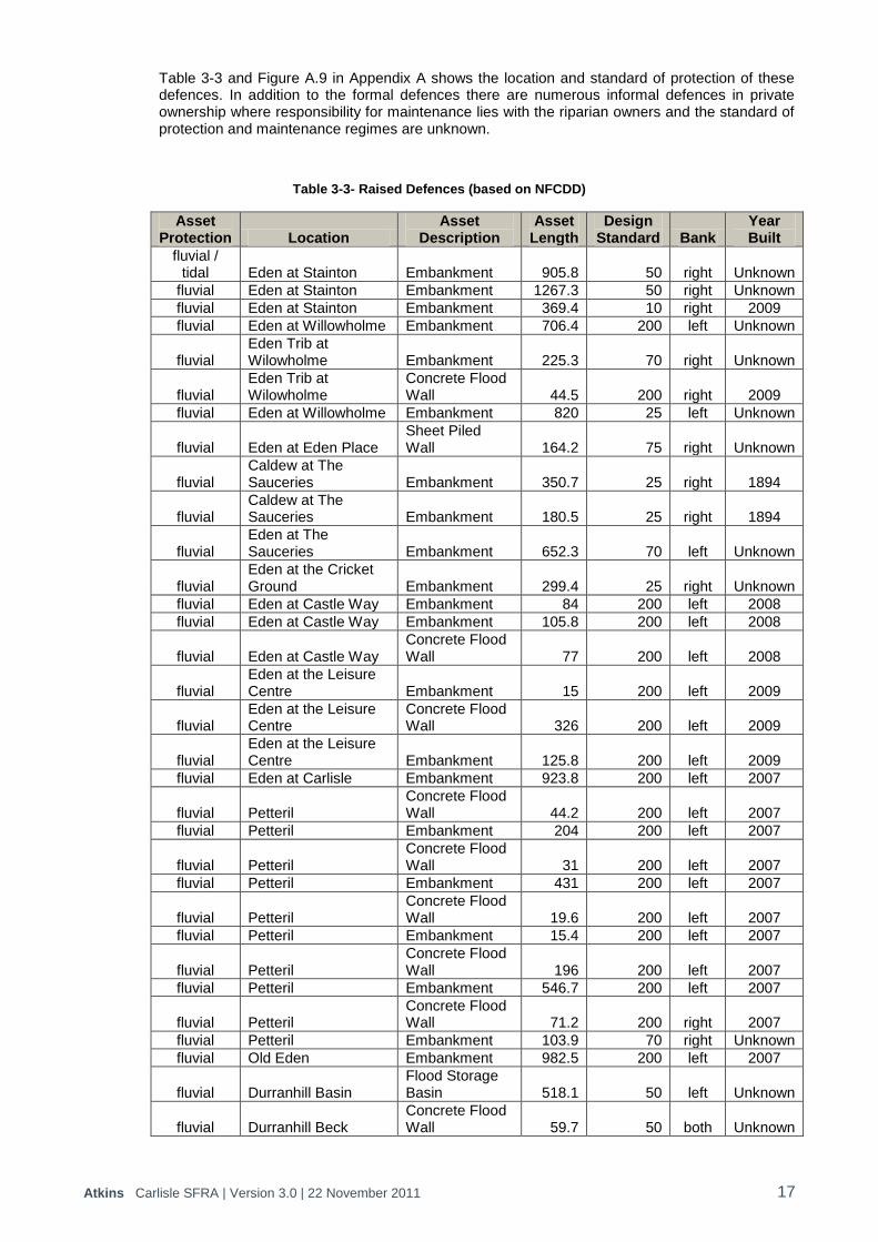
Table 3-3 and Figure A.9 in Appendix A shows the location and standard of protection of these defences. In addition to the formal defences there are numerous informal defences in private ownership where responsibility for maintenance lies with the riparian owners and the standard of protection and maintenance regimes are unknown.
Table 3-3- Raised Defences (based on NFCDD)
Asset Protection Location
Asset Description
Asset Length
Design Standard Bank
Year Built
fluvial / tidal Eden at Stainton Embankment 905.8 50 right Unknown
fluvial Eden at Stainton Embankment 1267.3 50 right Unknown
fluvial Eden at Stainton Embankment 369.4 10 right 2009
fluvial Eden at Willowholme Embankment 706.4 200 left Unknown
fluvial Eden Trib at Wilowholme Embankment 225.3 70 right Unknown
fluvial Eden Trib at Wilowholme
Concrete Flood Wall 44.5 200 right 2009
fluvial Eden at Willowholme Embankment 820 25 left Unknown
fluvial Eden at Eden Place Sheet Piled Wall 164.2 75 right Unknown
fluvial Caldew at The Sauceries Embankment 350.7 25 right 1894
fluvial Caldew at The Sauceries Embankment 180.5 25 right 1894
fluvial Eden at The Sauceries Embankment 652.3 70 left Unknown
fluvial Eden at the Cricket Ground Embankment 299.4 25 right Unknown
fluvial Eden at Castle Way Embankment 84 200 left 2008
fluvial Eden at Castle Way Embankment 105.8 200 left 2008
fluvial Eden at Castle Way Concrete Flood Wall 77 200 left 2008
fluvial Eden at the Leisure Centre Embankment 15 200 left 2009
fluvial Eden at the Leisure Centre
Concrete Flood Wall 326 200 left 2009
fluvial Eden at the Leisure Centre Embankment 125.8 200 left 2009
fluvial Eden at Carlisle Embankment 923.8 200 left 2007
fluvial Petteril Concrete Flood Wall 44.2 200 left 2007
fluvial Petteril Embankment 204 200 left 2007
fluvial Petteril Concrete Flood Wall 31 200 left 2007
fluvial Petteril Embankment 431 200 left 2007
fluvial Petteril Concrete Flood Wall 19.6 200 left 2007
fluvial Petteril Embankment 15.4 200 left 2007
fluvial Petteril Concrete Flood Wall 196 200 left 2007
fluvial Petteril Embankment 546.7 200 left 2007
fluvial Petteril Concrete Flood Wall 71.2 200 right 2007
fluvial Petteril Embankment 103.9 70 right Unknown
fluvial Old Eden Embankment 982.5 200 left 2007
fluvial Durranhill Basin Flood Storage Basin 518.1 50 left Unknown
fluvial Durranhill Beck Concrete Flood Wall 59.7 50 both Unknown

Atkins Carlisle SFRA | Version 3.0 | 22 November 2011 18
Asset Protection Location
Asset Description
Asset Length
Design Standard Bank
Year Built
fluvial Durranhill Beck Sheet Piled Wall 91.6 200 left 2008
fluvial Petteril Embankment 463.2 200 right 2007
fluvial Brunstock Beck at Rickerby
Concrete Flood Wall 45.4 70 left Unknown
fluvial Caldew at Carlisle Concrete Flood Wall 213.3 200 right 1876
fluvial Caldew at Carlisle Concrete Flood Wall 196.6 200 right 2009
fluvial Caldew at Carlisle Concrete Flood Wall 79.2 200 right 2009
fluvial Caldew at Carlisle Embankment 13.1 200 right 2009
fluvial Caldew at Carlisle Concrete Flood Wall 211.8 200 right 2009
fluvial Caldew at Denton Holme
Concrete Flood Wall 840.8 200 right 2009
fluvial Caldew at Willowholme
Concrete Flood Wall 195.7 200 left 2009
fluvial Caldew at Willowholme Building 1265.6 200 left Unknown
fluvial Caldew at Denton Holme Embankment 330 200 left 2009
fluvial Caldew at Denton Holme
Sandstone Flood Wall 193 200 left 2009
fluvial Caldew at Denton Holme
Sandstone Flood Wall 6.4 40 right Unknown
fluvial Caldew at Denton Holme
Sandstone Flood Wall 6.9 40 left Unknown
fluvial Little Caldew at Denton Holme Brick Flood Wall 22.6 40 left Unknown
fluvial Little Caldew at Denton Holme Brick Flood Wall 23.2 40 right Unknown
fluvial Caldew Embankment 647.8 70 right Unknown
fluvial Caldew at Denton Holme Brick Flood Wall 130.1 50 left Unknown
fluvial
Little Caldew at Denton Holme
Brick Flood Wall
45.9
40
left
Unknown
fluvial Little Caldew at Denton Holme Brick Flood Wall 21.6 40 left Unknown
fluvial Little Caldew at Denton Holme Brick Flood Wall 11.6 40 right Unknown
fluvial Little Caldew at Denton Holme Brick Flood Wall 59.3 40 left Unknown
fluvial Little Caldew at Caldewgate
Concrete Flood Wall 83.9 30 left Unknown
fluvial Little Caldew at Caldewgate
Sandstone Flood Wall 101.8 50 left Unknown
fluvial Little Caldew at Caldewgate Brick Flood Wall 176 50 right Unknown
fluvial Caldew at Willowholme Embankment 88.4 200 left 2009
fluvial Caldew at Willowholme
Concrete Flood Wall 95.4 200 left 2009
fluvial Caldew at Willowholme
Sheet Pile and Embankment 150.5 200 left 2009
fluvial Little Caldew at Willowholme
Sheet Piled Wall 48.4 200 left 2009
fluvial Little Caldew at Willowholme
Concrete Flood Wall 97.5 30 left Unknown

Atkins Carlisle SFRA | Version 3.0 | 22 November 2011 19
Asset Protection Location
Asset Description
Asset Length
Design Standard Bank
Year Built
fluvial Little Caldew at Willowholme Building 109.5 50 left Unknown
fluvial Little Caldew at Willowholme
Concrete Flood Wall 48.7 50 left 1994
fluvial Petteril at Harraby Green Embankment 282 200 right 2007
fluvial Petteril at Harraby Green
Sheet Piled Wall 131.4 200 right 2007
fluvial Dow Beck at Caldewgate Embankment 38.8 30 right Unknown
3.8. Flood Warning In addition to flood defences to reduce the probability of flooding, flood warning has been in operation in the Eden catchment for a number of years as a means of reducing the impacts of flooding. A range of systems have been in operation in various parts of the catchment operated by the Environment Agency. The lower reaches of the Eden through Carlisle benefit from relatively accurate forecasts with good lead-times based on upstream water levels and the Eden Real time flood forecasting model.
There are several flood warning services currently provided for areas at risk of flooding within Carlisle, these include:
The River Caldew at Cummersdale, Factory
The River Caldew at Carlisle, Viaduct Estate Road Area
The River Caldew at Carlisle, Denton Holme, Bousteads Grassing, James Street Area
River Caldew at Denton Holme, Bousteads Grassing and James Street Area
River Petteril at Harraby Green
Little Caldew
The River Caldew and Eden at Carlisle, Willowholme, Caldewgate, Shaddongate
River Eden at Eden Golf Course area
River Eden at Warwick Holme area
River Eden at Village, Holme End and Holme Gate
River Eden at Wetheral
River Eden at Carlisle, Rickerby Park, Swifts and Stoneyholme Golf Courses
River Eden at Carlisle, Etterby Terrace and Eden Place
The River Eden and Caldew at Carlisle, Devonshire Walk and West Coast Mainline, Bitts Park, Cricket Club, Sheepmount
River Eden at Carlisle, Rickerby Village
River Eden and Petteril at Carlisle, City Centre, Botcherby and Warwick Road Area
Durranhill Pumping Failure
River Eden at Carlisle, Civic Centre and Rickergate Area
River Eden at Carlisle Tesco Store Warwick Road
The River Eden at Stainton
River Eden at Warwick Bridge, Holme House and Bridge End
River Eden at Warwick Bridge, Holme Eden Area
River Eden at Warwick Bridge, Warwick Hall, School House, Chapel Close, Little Corby
Cumbrian coastline from Gretna to Silloth including Port Carlisle, Skinburness and Rockcliffe
The above Flood Warning Areas are based on the Extreme Flood Outline. The Extreme Flood Outline contains data on historic flooding. This is because some known historic flooding has occurred outside of Flood Zone 2.
In addition to the above Flood Warning Areas, Carlisle is covered by general early alerts to possible flooding, known as Flood Alerts, these include:
Atkins Carlisle SFRA | Version 3.0 | 22 November 2011 20
Coast from Gretna to Silloth Lower River Eden: River Eden and its tributaries from its confluence with the River Irthing
through Crosby-on-Eden and Carlisle to the Solway Firth at Rockcliffe
Middle River Eden: River Eden and tributaries from Temple Sowerby to the confluence with the River Irthing at Warwick Bridge including Langwathby, Lazonby, Kirkoswald, Armathwaite, Wetheral and Warwick on Eden
Rivers Caldew and Petteril: Rivers Caldew and Petteril from the Lakeland Fells to their confluences with the Eden in Carlisle including Greystoke, Newton Reigny, Plumpton, Stockdalewath, Sebergham and Dentonholme in Carlisle.
Rivers Esk and Irthing
A Surface Water Flood Warning Area covers Willowholme.
3.9. Development Control Carlisle City Council and the Environment Agency have staff dedicated to the control of development within Carlisle.
The Town and Country Planning System is designed to regulate the development and use of land in the public interest. It is the means by which the environment can be enhanced and protected whilst enabling development to take place which is necessary for economic and social well-being. Carlisle City Council‟s Development Control seeks to ensure the aims of the Town and Country Planning System are achieved through the submission and determination of applications for planning permission for development
The Carlisle Core Strategy Development Plan Document will, once adopted, set out the vision, strategic objectives and spatial strategy for future developments within the City of Carlisle and the wider district area. Development Control Policies are a suite of criteria-based policies which are required to ensure that all development within the areas meets the spatial vision and spatial objectives set out in the Core Strategy. These Development Control policies will include policies for development within floodplains and will be incorporated into the Core Strategy.
The Environment Agency has a role in advising the town and country planning process and will object to inappropriate development within areas at risk of flooding. If planners are minded to go against Environment Agency advice and approve proposed development, they are required to refer the proposal to the Secretary of State
9.
The Environment Agency has direct control over activities that may affect watercourses and the floodplain. According to the Water Resources Act 1991 and local byelaws, anyone wishing to carry out work in, over, under or within 8 metres from the top of bank of a main river, or 5 metres from an Internal Drainage Board watercourse needs consent from the Environment Agency. Under the Land Drainage Act 1991 and byelaws, any proposal to construct works within any other watercourse also needs Environment Agency consent.
The Environment Agency‟s Development Control teams support the planning system through the provision of advice and information on flood risk to planning authorities and developers to enable full compliance with PPS25.
3.10. Potential Development Sites Information on land with potential for development within Carlisle has been obtained from the Strategic Housing Land Availability Assessment10 and the Employment Sites Study.11
The location of all of these potential development sites is shown on Figure A.2 of Appendix A and the details are provided in Appendix B.
9 Town and Country Planning (Flooding) England Direction, 2007
10 Strategic Housing Land Availability Assessment. Draft Report. Carlisle City Council. October 2010.
11 Carlisle Employment Sites Study: Implications for M6 Corridor. Final Report. Carlisle City Council. June 2010

Atkins Carlisle SFRA | Version 3.0 | 22 November 2011 21
3.11. Consultation
3.11.1. Carlisle City Council The planning department have been consulted to identify areas under pressure from development and the sites which have been allocated for potential development.
3.11.2. Cumbria County Council Cumbria County Council has been consulted on the Surface Water Management Plan. Consultation has also been undertaken with staff from highway drainage and emergency planning.
3.11.3. Environment Agency Carlisle is within the North Area of the North West Region of the Environment Agency. Staff within the Flood Risk Mapping and Data Management and Asset Management teams have been consulted to obtain information on sources of flood risk, hydraulic modelling, flood defences and flood warning as well as to discuss future sustainable flood risk management and mitigation measures.
3.11.4. United Utilities United Utilities have been consulted to obtain information on the number of recorded incidences of sewer flooding and on the recent and future investment in infrastructure within Carlisle.
3.11.5. Neighbouring Planning Authorities Although the District of Carlisle has boundaries with 4 other local planning authorities the impact of developments within these areas on flood risk through Carlisle City is minimal. The reason for this is that the watercourses draining Dumfries and Galloway, Tynedale District and Allerdale District do not drain into Carlisle City. The only watercourses draining from other planning authorities into Carlisle City are the River Eden and it‟s tributaries from the Eden District. However, the River Esk draining through Dumfries and Galloway enters Longtown within Carlisle District.
A Strategic Flood Risk Assessment12 was completed in October 2007 for Eden District. The report provides recommendations on the control of development to ensure there is no adverse impact within the District and, therefore, within Carlisle downstream. The report recommends that:
Where other planning considerations must guide the allocation of sites and the Sequential Test cannot be satisfied, specific recommendations have been provided to assist the Council and the developer to meet the Exception Test. These should be applied as development control conditions for all future development. It is essential that these are applied, not only where there is a direct risk of flooding to the proposed development site, but elsewhere within the District. It is important to recognise that all development may potentially have an adverse impact upon the existing flooding regime if not carefully mitigated.
Council policy is essential to ensure that the recommended development control conditions can be imposed consistently at the planning application stage. This is essential to achieve future sustainability within the District with respect to flood risk management. It is recommended that future revisions to Council policy are developed.
12
Strategic Flood Risk Assessment. Eden District Council. October 2007
Atkins Carlisle SFRA | Version 3.0 | 22 November 2011 22
4. Flood Risk in Carlisle
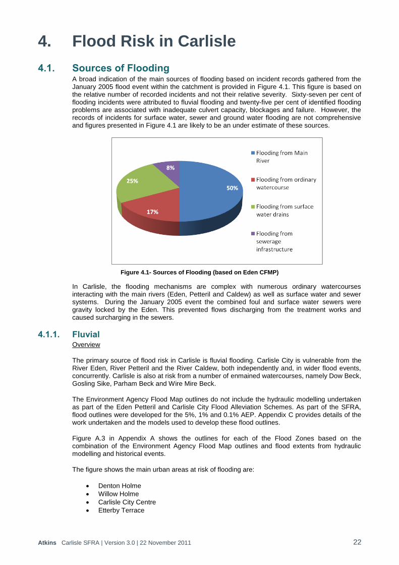
4.1. Sources of Flooding A broad indication of the main sources of flooding based on incident records gathered from the January 2005 flood event within the catchment is provided in Figure 4.1. This figure is based on the relative number of recorded incidents and not their relative severity. Sixty-seven per cent of flooding incidents were attributed to fluvial flooding and twenty-five per cent of identified flooding problems are associated with inadequate culvert capacity, blockages and failure. However, the records of incidents for surface water, sewer and ground water flooding are not comprehensive and figures presented in Figure 4.1 are likely to be an under estimate of these sources.
Figure 4.1- Sources of Flooding (based on Eden CFMP)
In Carlisle, the flooding mechanisms are complex with numerous ordinary watercourses interacting with the main rivers (Eden, Petteril and Caldew) as well as surface water and sewer systems. During the January 2005 event the combined foul and surface water sewers were gravity locked by the Eden. This prevented flows discharging from the treatment works and caused surcharging in the sewers.
4.1.1. Fluvial Overview
The primary source of flood risk in Carlisle is fluvial flooding. Carlisle City is vulnerable from the River Eden, River Petteril and the River Caldew, both independently and, in wider flood events, concurrently. Carlisle is also at risk from a number of enmained watercourses, namely Dow Beck, Gosling Sike, Parham Beck and Wire Mire Beck.
The Environment Agency Flood Map outlines do not include the hydraulic modelling undertaken as part of the Eden Petteril and Carlisle City Flood Alleviation Schemes. As part of the SFRA, flood outlines were developed for the 5%, 1% and 0.1% AEP. Appendix C provides details of the work undertaken and the models used to develop these flood outlines.
Figure A.3 in Appendix A shows the outlines for each of the Flood Zones based on the combination of the Environment Agency Flood Map outlines and flood extents from hydraulic modelling and historical events.
The figure shows the main urban areas at risk of flooding are:
Denton Holme
Willow Holme
Carlisle City Centre
Etterby Terrace

Atkins Carlisle SFRA | Version 3.0 | 22 November 2011 23
Rickerby
Warwick Road
Harraby Green
Delineation of Zone 1 Low Probability
Zone 1 Low Probability is defined as those areas of land that are outside of the shaded Zone 2 and Zone 3 flood risk areas (as defined below).
Delineation of Zone 2 Medium Probability
Zone 2 Medium Probability is defined as those areas of the District that are situated between the 0.1% AEP (1 in 1000) and the 1% AEP (1 in 100) fluvial flood extents. The detailed hydraulic modelling outputs, where available (refer to Section 3.4), have been adopted for the delineation of Zone 2 Medium Probability. It should be noted that quarterly revisions of the Environment Agency Flood Map are carried out so that more detailed information will be incorporated such that the Flood Zone Map is consistent with the detailed modelled outlines. Where there is no detailed hydraulic modelling, the Environment Agency Flood Map represents Flood Zone 2.
Delineation of Zone 3a High Probability
Zone 3a High Probability is defined as those areas of the District that are situated below (or within) the 1% AEP (1 in 100) fluvial flood extent. The detailed hydraulic modelling outputs, where available (refer to Section 3.4), have been adopted for the delineation of Zone 3a High Probability. It should be noted that quarterly revisions of the Environment Agency Flood Map are carried out so that more detailed information will be incorporated such that the Flood Zone Map is consistent with the detailed modelled outlines. Where there is no detailed hydraulic modelling, the Environment Agency Flood Map represents Flood Zone 3a.
Delineation of Zone 3b Functional Floodplain
Zone 3b Functional Floodplain comprises “land where water has to flow or be stored in times of flood” and PPS25 defines this as “land which would flood with an annual probability of 1 in 20 (5%) or greater in any year or is designed to flood in an extreme (0.1%) flood, or at another probability to be agreed between the LPA and the Environment Agency, including water conveyance routes”.
For the purposes of the SFRA, functional floodplain represents land which is subject to flooding with a 5% AEP or the area which is on the wet side of a raised defence. It also includes areas of land which are designed for flood storage, e.g. washlands.
4.1.2. Tidal Analysis of the tidal effect was carried out using a computer model as part of the technical review of the January 2005 Floods (Environment Agency 2006). This model indicates that the tidal effect is limited by a weir near Davidson‟s Bank and that tide levels in excess of those in January 2005 would have no effect on the River Eden levels in Carlisle. There are no locations identified to be at risk from sea flooding at the 0.5 per cent AEP (200 year return period) within the catchment.
4.1.3. Sewers The sewerage infrastructure of Carlisle is largely based on Victorian sewers and there is a risk of localised flooding associated with the existing drainage and sewer system.
Flooding from sewers can occur when the artificial drainage system is overwhelmed hydraulically, becomes blocked or suffers structural failure or pump failure. Blockage and structural failure incidents tend to be isolated and unpredictable. United Utilities is responsible for the management of the urban drainage system throughout Carlisle including surface water and foul sewerage. United Utilities has procedures in place to respond to and rectify such incidents, which are also recorded on databases to inform maintenance and improvement plans.

Atkins Carlisle SFRA | Version 3.0 | 22 November 2011 24
A review of areas where the sewer system has been overwhelmed can potentially identify under capacity of the drainage system or where the system does not provide an adequate level of service. United Utilities maintains an extensive database of incidents of hydraulic overload of sewers. This is a strategic level problem and is addressed by United Utilities through their ongoing asset management procedures, supported by a programme of detailed network modelling. United Utilities has the following target levels of protection against sewer flooding of properties:
Foul and combined systems: 1 in 10 to 1 in 50 years (depending on property type).
Surface water system: 1 in 10 to 1 in 30 years (depending on property type).
Wherever possible, United Utilities seeks to promote the highest specified standard. However, this is dependent on the cost-benefit analysis of the improvement scheme. It is therefore not appropriate for the SFRA to recommend strategic options for managing sewer flooding where levels of protection to properties are inadequate as this is a fundamental part of United Utilities‟ existing asset management procedures.
However, United Utilities has made the database of hydraulic overload incidents available and this can form a useful dataset for informing the spatial planning process with regard to flood risk. Figure A.4 in Appendix A shows the location of recorded internal and external flooding incidents. Within the context of strategic planning, identification of these hotspots will inform Carlisle City Council of areas where increased levels of investment may be required by developers to improve the hydraulic capacity of the existing sewer system. It is essential to ensure that future development does not exacerbate known existing problems and conditions should be placed upon future development to ensure that these capacity issues are rectified before development is permitted to proceed. It is important, however, to consider that all hydraulic improvements to the systems, required due to new development, are subject to approval in line with the strategies and policies of United Utilities.
Based on information collected as part of the post January 2005 flood event review, the locations identified where flooding occurred from sewerage infrastructure were recorded in Carlisle at a number of locations, Denton Holme, Willowholme, City, Etterby Terrace and Rickerby. It is likely that this flooding could be caused by hydraulic overload to the sewer system. Figure A.4 shows a concentration of sewer incidents within the City, especially around Willowholme, but there are also isolated incidents within neighbouring villages.
In November 2010 United Utilities completed a scheme where two large final effluent storm pumps were installed at the wastewater treatment works in Carlisle, completing a £3.4 million scheme to help protect the Willowholme area from the sort of devastating floods which hit 2,000 homes in 2005. Now, huge amounts of final effluent can be pumped safely into the River Eden during periods of intense rain, even when the river is high. The two pumps themselves consist of huge specially-made steel Archimedean screws able to lift and shift 3,200 litres of water every second between them.
With regards to planned future investment, United Utilities are planning a major scheme at Carlisle WwTW with a planned project delivery date of 31/3/2015. Carlisle WwTW currently serves a total population of 80,261. Carlisle has been subject to considerable historical development, which has exhausted the works biological secondary treatment headroom. Carlisle is designated as a Growth Point and significant domestic development is forecast within the Catchment resulting in a 30% increase in population to 105,219 by 2031. United Utilities has been funded to increase the Population Equivalent (PE) capacity of Carlisle WwTW by 24,960 as part of the AMP5 Supply and Demand investment programme.
It should be noted that there are other small scale improvements and maintenance investment planned within the Carlisle network and at the WwTW, in addition to the major capital investment project outlined above.
Pipe leakage is a common and widespread problem throughout the UK and can contribute to basement flooding in some areas. Pipe leakage within Carlisle is managed by United Utilities as a fundamental part of their asset management procedures.
Atkins Carlisle SFRA | Version 3.0 | 22 November 2011 25
Pipe bursts tend to be isolated and unpredictable incidents. United Utilities has procedures in place to respond to and rectify such incidents.
4.1.4. Groundwater The geology of the District is dominated by sandstone and mudstones to the western side of the Eden and Limestone of the Carboniferous series to the east and around Carlisle, forming an extensive outcrop. The area downstream of and to the west of Carlisle is of low relief and underlain by mudstone of the Mercia, Permo-Triassic and Lias, Jurassic ages. Both are considered to be non-aquifers. Superficial deposits consist of alluvium deposits in the floodplain interspersed with areas of sand and gravel. Alluvium is found immediately adjacent to the Rivers Eden, Caldew and Irthing and it is extensive in the area around Carlisle. Where groundwater exists it flows through strata very slowly and in limited quantities. The Environment Agency has no record of any historical flooding incidences arising from groundwater within Carlisle.
The Areas Susceptible to Groundwater Flooding map is a strategic scale map showing groundwater flood areas on a 1km square grid (see Figure A.5 in Appendix A). This data has used the top two susceptibility bands of the British Geological Survey 1:50,000 Groundwater Flood Susceptibility Map and thus covers consolidated aquifers, e.g. Triassic Sandstone and superficial deposits. It does not take account of the chance of flooding from groundwater rebound. It shows the proportion of each 1km grid square where geological and hydrogeological conditions show that groundwater might emerge. The susceptible areas are represented by one of four area categories (<25%; 25%-50%, 50%-75%, >75%) showing the proportion of each 1km square that is susceptible to groundwater emergence. It does not show the likelihood of groundwater flooding occurring.
Only isolated locations within the overall susceptible area are actually likely to suffer the consequences of groundwater flooding. The map does not display where groundwater is actually likely to flow or pond but the information can inform site specific FRAs in identifying where, for example, further investigation may be useful.
Figure A.5 shows that the areas susceptible to groundwater flooding are predominantly within the river gravels of the River Eden and its tributaries. Areas within Carlisle which are susceptible to groundwater flooding include, Botcherby, Rickerby, Willowholme and Caldewgate/Shaddongate.
4.1.5. Reservoirs Castle Carrock Reservoir is part of United Utilities Carlisle Water Resource Zone which impounds water from the River Gelt and serves residents within Carlisle City and the surrounding villages.
The Environment Agency operates a Flood Storage Basin at Durranhill adjacent to Warwick Road where Durranhill Beck flows through the main River Eden flood embankment. There is a pumping station which operates in flood conditions pumping water collecting behind the flood defences in the basin over into the Eden floodplain. The basin is classed as a reservoir under the Reservoir Act and has a standard of protection of 1% AEP (1 in 100 years) in terms of overtopping its own embankments onto Warwick Road.
Another upstream Flood Storage solution also classed as a reservoir is nearing completion on Lochinvar Beck in Longtown which gives improved flood protection to around 70 properties.
Flooding from reservoirs can occur when water retaining structures fail. All large reservoirs are covered by the Reservoirs Act and are subject to regular safety inspections. A very low residual risk of flooding from these reservoirs remains if they were to fail unexpectedly, however this is considered to be a risk that is managed by the Water Companies or the Local Authority.
The Pitt Review into the 2007 summer floods recommended that the Government should produce reservoir flood maps for all large raised reservoirs. The Environment Agency has now produced reservoir flood maps which they regulate under the Reservoirs Act 1975. The reservoir flood maps are required to ensure that emergency responders know, for example, who may be at risk and should be evacuated in the event of an individual reservoir failure. The maps are produced assuming that the reservoir is holding the maximum volume of water it is capable of
Atkins Carlisle SFRA | Version 3.0 | 22 November 2011 26
holding at the time of failure. The maps show the credible worse case flood pattern should the reservoir be at full capacity.
The Reservoir map for Castle Carrock is provided in Figure A.6 in Appendix A. In addition to Castle Carrock, the Carlisle District is also at potential risk from the failure of Haweswater which flows into the River Lowther, via the River Eamont which is a tributary of the River Eden.
The village of Castle Carrock and isolated properties at Middle Geltbridge and Low Geltbridge are at risk from the failure of the retaining structure of Castle Carrock Reservoir. Large areas of Carlisle City and isolated properties in surrounding villages are at risk from the failure of the retaining structure of Haweswater Reservoir.
It should be noted that the reservoir map assumes an undefended scenario, so whilst the map shows areas of Carlisle at potential risk of flooding from the failure of the retaining structure of Haweswater Reservoir, these areas are benefiting from flood defences along the River Eden.
4.1.6. Surface Water Surface water flooding occurs when excess water runs off across the surface of the land. Surface water flooding has the potential to contribute significant flood risk in urban areas due to the rapid run off rates associated with urban land use.
Surface water flooding, either on its own or as a contributing factor in other types of flooding is considered to be relatively frequent. The scale of the disruption or damage caused is less certain, and there are few records of significant losses resulting from surface water flooding.
Making Space for Water13 defines surface water flooding as an “event that results from rainfall generated overland flow before the runoff enters any watercourse or sewer. Usually associated with high intensity rainfall (typically >30mm/hr) resulting in overland flow and ponding in depressions in the topography, but can also occur with lower intensity rainfall or melting snow where the ground is saturated, frozen, developed or otherwise has low permeability. Urban underground sewerage/drainage systems and surface watercourses may be completely overwhelmed, preventing drainage. Surface water flooding does not include sewer surcharge in isolation.‟
The Areas Susceptible to Surface Water Flooding (AStSWF) maps show areas where surface water would be expected to flow or pond. The map was procured as a preliminary national output to provide Local Resilience Forums with an initial indication of areas that may be susceptible to surface water flooding. It was also provided to Regional Resilience Teams for use in their functions which relate to emergencies as defined and as required by the Civil Contingencies Act 2004 and to LPAs for land use planning purposes.
The AStSWF maps are based on the modelling of a single rainfall event with a 1 in 200 chance of occurring in any year. The maps display the chance of this rainfall and not of the resulting flood extent occurring. Consequently, the map provides only a general indication of areas which may be more likely to suffer from surface water flooding for this rainfall probability. The map provides three bandings, indicating „less‟ to „more‟ susceptible to surface water flooding. The AStSWF map is shown in Figure A.7 in Appendix A.
The AStSWF map shows there are substantial areas of Carlisle City susceptible to surface water flooding including Botcherby, Willowholme, Caldewgate, Denton Holme, Longsowerby, Currock, Harraby, Newtown, Knowefield and Edentown. There are also towns outside of Carlisle which are susceptible to surface water flooding, e.g. Longtown.
The Flood Map for Surface Water (FMfSW) was developed from a number of improvements to the original model in areas where it was known to be weaker; for example considering:
more storm events;
the influence of buildings;
the influence of the sewer system.
13
Making Space for Water – Flooding from other sources (HA4a), 2006, Defra.

Atkins Carlisle SFRA | Version 3.0 | 22 November 2011 27
Two rainfall events, one with a 1 in 30 and the other with a 1 in 200 chance of occurring in any year, are modelled and mapped. The map shows Surface Water flooding greater than 0.1m deep, Deeper Surface Water Flooding greater than 0.3m deep and flooding between 0.1 and 0.3m deep. The 0.3m threshold was chosen as it represents a typical value for the onset of significant property damages when property flooding may start (above doorstep level) and because it is at around this depth that moving through floodwater (driving or walking) may become more difficult; both of which may lead users to consider the need to close roads or evacuate areas.
The FMfSW map is shown in Figure A.8 in Appendix A. The map shows that there are isolated areas in Botcherby, Willowholme, Caldewgate, Denton Holme, Longsowerby, Currock, Harraby, Newtown, Knowefield and Edentown which are at risk from depths of surface water flooding of greater than 0.3m.
4.1.7. Failure or Blockage of Critical Assets Flooding can result from the failure or blockage of critical assets, for example culverts or bridges. When trash screens become significantly reduced due to the build up of debris, or where blockages occur at the inlet to culverts, there is potential for localised flooding to result. The floodwater backs up and can flood nearby land or low-lying areas as it finds an alternative route around the culvert or structure.
For example, the culverts along Duranhill Beck under Warwick Road and Eastern Way are susceptible to blockage. Consequently, water quickly accumulates upstream of the culverts which has led to overtopping of the structures and localised flooding.
4.2. Flood Defences Where there are flood defences with a standard of protection of at least 100 years, the area benefiting from these defences has been assessed. Figure A.9 in Appendix A shows the areas benefiting from flood defences for a 1% AEP event. The main areas benefiting from flood defences along the River Eden, River Petteril and River Caldew are Willowholme, Caldewgate, Denton Holme and Warwick Road Areas. These flood defences were largely constructed as part of the Eden Petteril and Carlisle City and Caldew Flood Alleviation Schemes. The Eden Petteril Scheme was completed in spring 2008 and protects nearly 1,500 properties, using four kilometres of raised flood defences. The Carlisle City and Caldew Scheme was completed in 2010 and protects a further 1,137 properties and includes five kilometres of raised flood defences and a pumping station on the Little Caldew.
Within Carlisle there is also some length of flood defences which have less than a 100 year design standard. Whilst these defences offer protection to properties for flood events up to their design standard, for the 1% AEP event the defences offer little protection and are overtopped.
4.3. Flood Risk Sensitivity A sensitivity analysis has been undertaken of the risk of flooding in Carlisle to potential changes caused by climate change and the variability associated with urban development and land management practices. In addition, the impact of overtopping and breaching of flood defences on flood risk has been considered.
4.3.1. Flood Sensitivity to Climate Change The Eden CFMP identifies that climate change is expected to have a major influence on future flood risk. The expectations are that winter floods will happen more often and in urban areas flooding from thunderstorms will be more regular and more severe.
Recent guidance from Defra14
on assessing climate change sensitivity recommends assuming a 10% increase in fluvial flow up to 2025 and then an increase of 20% thereafter.
14
Flood and Coastal Defence Appraisal Guidance FCDPAG3 Economic Appraisal Supplementary Note to Operating Authorities – Climate Change Impacts. Defra. October 2006
Atkins Carlisle SFRA | Version 3.0 | 22 November 2011 28
Hydraulic modelling of the Eden, Caldew and Petteril has considered the potential impact of climate change over the next 100 years, assuming a 20% increase in the 1% (100 year) flow.
The outlines representing climate change in Figure A.10 in Appendix A indicate that there would be a small increase in the number of properties at risk of flooding compared with the 1% AEP outline. The areas where there is a potential impact from climate change are Caldewgate/Shaddongate, Denton Holme, Milbourne Street and Warwick Road but these are all areas benefitting from defences which have a standard of protection greater than a 1% AEP plus climate change event. Other areas where there is a potential impact from climate change are Rickerby and Warwick Bridge but these are not benefiting from flood defences.
4.3.2. Flood Sensitivity to Increased Urban Development The effects of flooding due to increases in urbanisation have been tested on a number of different catchments within the Eden CFMP. Results of the urbanisation sensitivity test (assuming 2.5% increase in urban area) indicate that peak flows within Carlisle could increase by as much as 4 per cent.
Storm run-off from impervious surfaces, if controlled and routed rapidly by artificial drainage networks, can increase flood peaks in watercourses downstream of new urbanised areas. There is also an increased risk of localised “flash flooding” in intense rainstorms. Urban growth will, therefore, increase surface water run-off rates and volumes with the potential for increasing flood risk unless new development is properly controlled.
However, new developments are unlikely to increase surface water flood risk for the following reasons:
Some of the new development is likely to be located on “brownfield” sites. These sites may already have connections to the drainage network. Therefore, unless the land use significantly increases the impermeable surface area, new development is unlikely to increase surface water flood risk. An exception to this would be where low density residential areas of large houses, with extensive gardens, are replaced by high density developments of flats or smaller houses. However, with the use of sustainable urban drainage schemes (SUDs) any potential adverse effects can be avoided.
For any “greenfield” allocations, surface water discharges from new developments into watercourses would be controlled to ensure existing greenfield runoff rates are maintained post development. Where consulted, the Environment Agency will provide comments on disposal of surface water.
Developers have to approach United Utilities to determine if they have the capacity to allow a new development to connect to the existing drainage system. United Utilities will either allow connection if they have capacity or inform the developer that an increase in capacity is required and that the developer would have to cover the cost before connection is permitted. However, connecting new developments into the United Utilities drainage system is not sustainable as surface water sewers discharge into the watercourses. Effort should be made to attenuate surface water runoff on the site so it does not put pressure on the existing drainage system or increase runoff into watercourses via the sewer network.
Clever design, situation and location of future development can, therefore, all contribute to reducing the risk of flooding, including:
Steering developments outside of the floodplain;
Application of property and location specific flood protection measures;
Improving property resilience to flood damage;
Identifying river corridors and the natural flood plain to provide potential riverside storage and urban river corridors in built up areas;
Application of sustainable urban drainage techniques for new developments.

Atkins Carlisle SFRA | Version 3.0 | 22 November 2011 29
4.3.3. Flood Sensitivity to Land Management Practices The volumes and rate of runoff from land into watercourses and rivers can be greatly affected by agricultural practices, such as the removal of hedgerows and woodland areas, reshaping landform and the provision of positive land drainage. Such practices can result in an increase in the flood risk from these watercourses to areas downstream.
There is a strong link between land use and land management practices and runoff generation at a plot or individual field scale. However, research into the potential impact of rural land use and land management practice on flood generation at a catchment scale is still underway. Ongoing research funded by Defra
15 and the Environment Agency is evaluating the impacts of rural land
use and land management on run-off and flood generation. So far, it has concluded that impacts are evident at the local scale (individual fields and very small stream catchments). Further research is required to identify and understand impacts for larger catchments. It also appears that land management effects are most notable for small to medium flood events. In extreme floods the overall volume of rainfall is the controlling factor for flood magnitude.
The influences for change in land use and land management have been explored in the Eden CFMP. The scope for increases in woodland cover to reduce the severity of major flood events is limited and the Eden CFMP suggests that a typical catchment requires a covering by forest of 10 per cent to produce a 2 per cent reduction in outflow. Less than 5 per cent of the land is forested in the Eden catchment and therefore a significant increase would be required for Carlisle to benefit from reduced flooding.
It is very difficult to predict future changes in agricultural land use and management within Carlisle; however as arable farming is already intensive in places, it is thought that any changes in land management practices are not going to significantly affect runoff and, therefore, flood risk.
4.3.4. Flood Sensitivity to Breach and Overtopping of Flood Defences
Overview
Areas behind flood defences are at risk due to the potential overtopping or breach of flood defences resulting in the rapid onset of fast-flowing and deep water flooding with little or no warning. Local Planning Authorities and developers need to consider these residual risk issues relating to a development.
The level of residual risk behind flood defences is dependent on the distance from and the relative elevation of the land in relation to the water source. Figure 4.2 below illustrates the various risk zones behind a river flood defence.
Figure 4.2 - Risk Zone behind Flood Defences
15
Defra / Environment Agency R&D Project Record FD2114/TR Review of impacts of rural land use and management on flood generation. (2004)
DefenceRiver
High Risk
"Rapid Inundation Zone"
High Risk
Deep Flooding
Medium Risk
Shallow Flooding
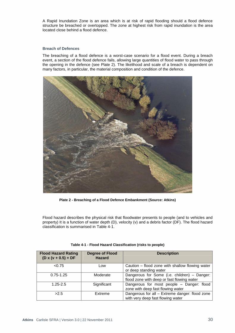
Atkins Carlisle SFRA | Version 3.0 | 22 November 2011 30
A Rapid Inundation Zone is an area which is at risk of rapid flooding should a flood defence structure be breached or overtopped. The zone at highest risk from rapid inundation is the area located close behind a flood defence.
Breach of Defences
The breaching of a flood defence is a worst-case scenario for a flood event. During a breach event, a section of the flood defence fails, allowing large quantities of flood water to pass through the opening in the defence (see Plate 2). The likelihood and scale of a breach is dependent on many factors, in particular, the material composition and condition of the defence.
Plate 2 - Breaching of a Flood Defence Embankment (Source: Atkins)
Flood hazard describes the physical risk that floodwater presents to people (and to vehicles and property) It is a function of water depth (D), velocity (v) and a debris factor (DF). The flood hazard classification is summarised in Table 4-1.
Table 4-1 - Flood Hazard Classification (risks to people)
Flood Hazard Rating (D x (v + 0.5) + DF
Degree of Flood Hazard
Description
<0.75 Low Caution – flood zone with shallow flowing water or deep standing water
0.75-1.25 Moderate Dangerous for Some (i.e. children) – Danger: flood zone with deep or fast flowing water
1.25-2.5 Significant Dangerous for most people – Danger: flood zone with deep fast flowing water
>2.5 Extreme Dangerous for all – Extreme danger: flood zone with very deep fast flowing water

Atkins Carlisle SFRA | Version 3.0 | 22 November 2011 31
Defra guidance FD232016 illustrates schematically (replicated in Figure 4.3) how danger to people or flood hazard varies in relation to the distance from a defence (or breach location).
Figure 4.3 - Flood Hazard from a Breach of Flood Defences
Breach analysis has been undertaken of the flood defences along the River Eden and River Caldew for the 1% and 0.5 AEP which protect properties in the five areas of Caldewgate/Shaddongate, Denton Holme, Milbourne Street, Rickergate and Willowholme.
Caldewgate/Shaddongate – Figure A11a in Appendix A shows that the area is affected by the breach of the flood defences along the River Caldew. The depth of flooding is less than 0.5 m and the velocity is less than 0.5 m/s. The degree of flood hazard for the areas affected by the breach is, therefore, considered to be low.
Denton Holme – Figure A12a in Appendix A shows that the area is affected by the breach of the flood defences along the River Caldew; however the majority of the area is unaffected by a breach. The depth of flooding is generally less than 0.5 m but there are some isolated areas on Viaduct Estate Road and Victoria Viaduct where depths are up to 1 m in depth. Similarly, velocities are generally less than 0.5 m/s. However, there are isolated areas where velocity may be in excess of 2 m/s, including Lorne Crescent, Milbourne Crescent, Victoria Viaduct, Lime Street and Elm Street. The degree of flood hazard for the areas affected by the breach is generally low but may be moderate or significant in areas of high velocity.
Milbourne Street – Figure A13a in Appendix A shows that the area is affected by the breach of the flood defences along the River Caldew. The depth of flooding is less than 0.5 m and the velocity is less than 0.5 m/s. The degree of flood hazard for the areas affected by the breach is, therefore, considered to be low.
Rickergate – Figure A14a in Appendix A shows that the area is affected by the breach of the flood defences along the River Eden. The depth of flooding is up to 3 m along Rickergate with lower depths along Peter Street. The velocity is generally less than 0.5 m/s. The degree of flood hazard for the areas affected by the breach is, therefore, considered to be significant along Rickergate but moderate or low hazard along Peter Street.
Willowholme – Figure A15a in Appendix A shows that the area is affected by the breach of the flood defences along the River Eden. The depth of flooding is up to 3 m along some parts of Willowholme Road and Millrace Road. The velocity is generally less than 0.5 m/s. The degree of flood hazard for the areas affected by the breach is, therefore, considered to be significant along parts of Willowholme Road and Millrace Road but moderate or low hazard in other areas.
16
Flood Risk Assessment Guidance for New Development: Phase 2 R&D Technical Report FD2320/TR2; Defra, October 2005

Atkins Carlisle SFRA | Version 3.0 | 22 November 2011 32
Overtopping of Defences
The majority of the flood defences within Carlisle have a standard of protection of greater than 1% AEP flood event. Where the existing defences have a standard of protection less than 1% AEP they will be easily overtopped and even submerged during a 1% AEP flood event (see Figure 4.4). Out of bank flow will occur in a manner almost as if no defences existed. In these circumstances flood depths, velocities and extent can be expected to be similar to the undefended situation.
Figure 4.4 - Overtopping of Defences with Standard of Protection less than 1% AEP
The flood defences along the River Eden, River Petteril and River Caldew which currently offer a standard of protection of 0.5% AEP event would be overtopped by more severe events, e.g. 0.1% AEP but also by increased water levels as a result of climate change. The result of overtopping of the flood defences is likely to result in a moderate level of risk in close proximity to the defences (100-200m) due to depths of water of >0.5m. However, at a greater distance (>500m) from the defences, the depth of flooding will be less as will the level of risk.
DefenceRiver
Floodplain
1% AEP inundates floodplain
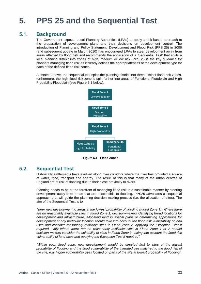
Atkins Carlisle SFRA | Version 3.0 | 22 November 2011 33
5. PPS 25 and the Sequential Test
5.1. Background The Government expects Local Planning Authorities (LPAs) to apply a risk-based approach to the preparation of development plans and their decisions on development control. The introduction of Planning and Policy Statement: Development and Flood Risk (PPS 25) in 2006 (and subsequent update in March 2010) has encouraged LPAs to steer development away from areas affected by flood risk and recommends the application of a „Sequential Test‟ that splits a local planning district into zones of high, medium or low risk. PPS 25 is the key guidance for planners managing flood risk as it clearly defines the appropriateness of the development type for each of the defined flood risk zones.
As stated above, the sequential test splits the planning district into three distinct flood risk zones, furthermore, the high flood risk zone is split further into areas of Functional Floodplain and High Probability Floodplain (see Figure 5.1 below).
Figure 5.1 - Flood Zones
5.2. Sequential Test Historically settlements have evolved along river corridors where the river has provided a source of water, food, transport and energy. The result of this is that many of the urban centres of England are at risk of flooding due to their close proximity to rivers.
Planning needs to be at the forefront of managing flood risk in a sustainable manner by steering development away from areas that are susceptible to flooding. PPS25 advocates a sequential approach that will guide the planning decision making process (i.e. the allocation of sites). The aim of the Sequential Test is to:
“steer new development to areas at the lowest probability of flooding (Flood Zone 1). Where there are no reasonably available sites in Flood Zone 1, decision-makers identifying broad locations for development and infrastructure, allocating land in spatial plans or determining applications for development at any particular location should take into account the flood risk vulnerability of land uses and consider reasonably available sites in Flood Zone 2, applying the Exception Test if required. Only where there are no reasonably available sites in Flood Zone 1 or 2 should decision-makers consider the suitability of sites in Flood Zone 3, taking into account the flood risk vulnerability of land uses and applying the Exception Test if required”.
“Within each flood zone, new development should be directed first to sites at the lowest probability of flooding and the flood vulnerability of the intended use matched to the flood risk of the site, e.g. higher vulnerability uses located on parts of the site at lowest probability of flooding”.
Flood Zone 1
Low Probability
Flood Zone 2
Medium Probability
Flood Zone 3
High Probability
Flood Zone 3a
High Probability
Flood Zone 3b
Functional Floodplain
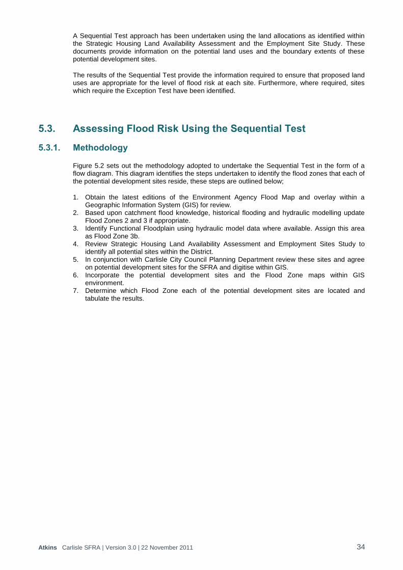
Atkins Carlisle SFRA | Version 3.0 | 22 November 2011 34
A Sequential Test approach has been undertaken using the land allocations as identified within the Strategic Housing Land Availability Assessment and the Employment Site Study. These documents provide information on the potential land uses and the boundary extents of these potential development sites.
The results of the Sequential Test provide the information required to ensure that proposed land uses are appropriate for the level of flood risk at each site. Furthermore, where required, sites which require the Exception Test have been identified.
5.3. Assessing Flood Risk Using the Sequential Test
5.3.1. Methodology
Figure 5.2 sets out the methodology adopted to undertake the Sequential Test in the form of a flow diagram. This diagram identifies the steps undertaken to identify the flood zones that each of the potential development sites reside, these steps are outlined below;
1. Obtain the latest editions of the Environment Agency Flood Map and overlay within a Geographic Information System (GIS) for review.
2. Based upon catchment flood knowledge, historical flooding and hydraulic modelling update Flood Zones 2 and 3 if appropriate.
3. Identify Functional Floodplain using hydraulic model data where available. Assign this area as Flood Zone 3b.
4. Review Strategic Housing Land Availability Assessment and Employment Sites Study to identify all potential sites within the District.
5. In conjunction with Carlisle City Council Planning Department review these sites and agree on potential development sites for the SFRA and digitise within GIS.
6. Incorporate the potential development sites and the Flood Zone maps within GIS environment.
7. Determine which Flood Zone each of the potential development sites are located and tabulate the results.

Atkins Carlisle SFRA | Version 3.0 | 22 November 2011 35
Figure 5.2 - Flow Diagram of Sequential Test Methodology
5.3.2. Summary of Results A summary of the Sequential Test results is provided within Table 5-1 below. The complete results of the analysis are contained within Appendix E. Figure A.16 in Appendix A contains a map showing the location of all 191 potential housing development sites, 92 potential employment development sites and the Flood Zone within which they are located.
Table 5-1 - Summary of the Potential Development Sites and Flood Zones
Development Type
Total Number of Potential
development sites
Flood Zone 1 Low
Probability
Flood Zone 2 Medium
Probability
Flood Zone 3a High
Probability
Flood Zone 3b Functional Floodplain
Housing 191 143 14 31 3
Employment 92 42 12 37 1
Many of the potential development sites are situated within more than one Flood Zone, where this is the case, the site is shown in the table as being in the zone with the higher probability of flooding.
In total, there are 283 potential development sites within the District Boundary. 185 of these sites are identified to fall within Flood Zone 1 „Low Probability‟ and therefore all uses of land/development types would be appropriate. However for developments on sites of 1 Ha or larger a site-specific Flood Risk Assessment is required.
26 sites are identified to be within Flood Zone 2 „Medium Probability‟. Water Compatible, Less Vulnerable, More Vulnerable and Essential Infrastructure are appropriate within this Zone. All development proposals within Flood Zone 2 require a Flood Risk Assessment.

Atkins Carlisle SFRA | Version 3.0 | 22 November 2011 36
The remaining 72 sites are all identified to fall within Flood Zone 3, of which 68 are within Flood Zone 3a „High Probability‟ and the remaining 4 within Flood Zone 3b „Functional Floodplain‟. In Zone 3a Less Vulnerable and Water Compatible uses are deemed appropriate. More Vulnerable and Essential Infrastructure require the Exception Test to be passed and Highly Vulnerable development should not be permitted. In Zone 3b only Water Compatible uses are deemed appropriate. Essential Infrastructure requires the Exception Test to be passed. All other uses should not be permitted.
5.3.3. Housing Sites Assessment of the flood risk vulnerability classification for each of these proposed housing development sites has resulted in 3 groupings:
Sites where proposed land use is appropriate
Sites which require application of the Exception Test
Sites where the intended land use is not appropriate
The first group, sites where land use is appropriate, contains 157 separate housing sites across Carlisle District and includes a mix of sites within Flood Zones 1 and 2.
The second group of sites; those which require the Exception Test to be undertaken, include a total of 31 sites each of which are located within Flood Zone 3a. The extent to which these sites are affected by Flood Zone 3a varies considerably and is shown in Table 5-2. In terms of the Sequential Test, these sites are only preferable once all other housing in lower flood risk zones have been taken up.
Table 5-2 - Summary of the Potential Housing Development Sites where the Exception Test is Required
Site Potential Development Site
Name Flood Zone
% in FZ 3a
In an Area Benefiting from Flood Defences
(ABD)?
BR 09 Land at The Grange, Craw
Hall FZ3a 22 No
CA 01 Mitchell Dryers FZ3a 100 Yes
CA 02 Riverside Way FZ3a 100 Yes
CA 04 Property between Denton Street-Collingwood Street
and Blencowe Street FZ3a 100 Yes
CA 14 Former Belah School FZ3a 11 No
CA 16 Land at Warwick Road FZ3a 100 Yes
CA 26 London Rd-Gillford Park FZ3a 15 No
CA 28 Land at Lorne Crescent FZ3a 101 Yes
CA 33a Botchergate, Crown St FZ3a 19 Yes
CA 33b Botchergate, Crown St FZ3a 67 Yes
CA 33d Botchergate, Crown St FZ3a 65 Yes
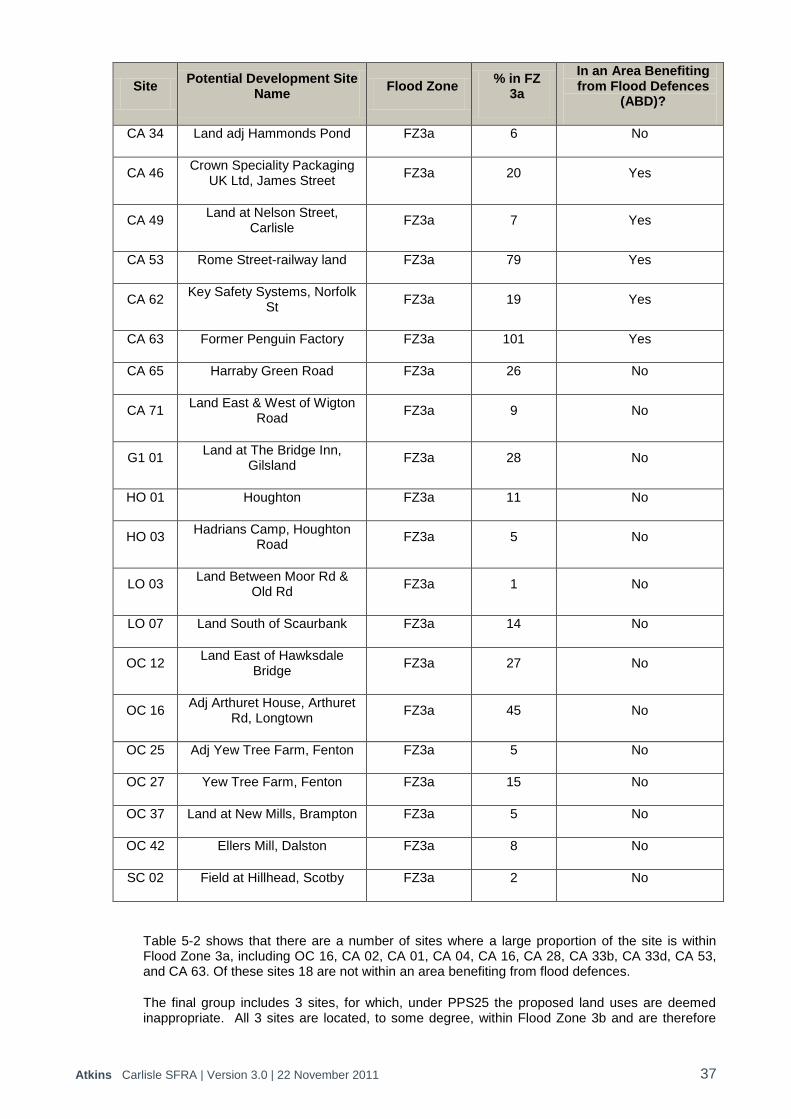
Atkins Carlisle SFRA | Version 3.0 | 22 November 2011 37
Site Potential Development Site
Name Flood Zone
% in FZ 3a
In an Area Benefiting from Flood Defences
(ABD)?
CA 34 Land adj Hammonds Pond FZ3a 6 No
CA 46 Crown Speciality Packaging
UK Ltd, James Street FZ3a 20 Yes
CA 49 Land at Nelson Street,
Carlisle FZ3a 7 Yes
CA 53 Rome Street-railway land FZ3a 79 Yes
CA 62 Key Safety Systems, Norfolk
St FZ3a 19 Yes
CA 63 Former Penguin Factory FZ3a 101 Yes
CA 65 Harraby Green Road FZ3a 26 No
CA 71 Land East & West of Wigton
Road FZ3a 9 No
G1 01 Land at The Bridge Inn,
Gilsland FZ3a 28 No
HO 01 Houghton FZ3a 11 No
HO 03 Hadrians Camp, Houghton
Road FZ3a 5 No
LO 03 Land Between Moor Rd &
Old Rd FZ3a 1 No
LO 07 Land South of Scaurbank FZ3a 14 No
OC 12 Land East of Hawksdale
Bridge FZ3a 27 No
OC 16 Adj Arthuret House, Arthuret
Rd, Longtown FZ3a 45 No
OC 25 Adj Yew Tree Farm, Fenton FZ3a 5 No
OC 27 Yew Tree Farm, Fenton FZ3a 15 No
OC 37 Land at New Mills, Brampton FZ3a 5 No
OC 42 Ellers Mill, Dalston FZ3a 8 No
SC 02 Field at Hillhead, Scotby FZ3a 2 No
Table 5-2 shows that there are a number of sites where a large proportion of the site is within Flood Zone 3a, including OC 16, CA 02, CA 01, CA 04, CA 16, CA 28, CA 33b, CA 33d, CA 53, and CA 63. Of these sites 18 are not within an area benefiting from flood defences.
The final group includes 3 sites, for which, under PPS25 the proposed land uses are deemed inappropriate. All 3 sites are located, to some degree, within Flood Zone 3b and are therefore
Atkins Carlisle SFRA | Version 3.0 | 22 November 2011 38
subject to the highest level of constraint on the type of development as imposed by PPS25. However, through the application of a more detailed site specific FRA in conjunction with careful planning of the site it may be possible to reduce the level of constraints imposed. Table 5-3 provides details of these sites. None of the sites are within areas benefiting from defences. Site OC17b has no clearly defined boundary and, therefore, the area in Flood Zone 3b adjacent to the River Petteril is unlikely to form part of the site if it is taken forward for development.
Table 5-3 - Summary of the Potential Housing Development Sites where Development is not Acceptable
Site Potential Development Site Name
Flood Zone % in FZ 3b
OC 17b South Western Edge of Carlisle FZ3b 1
CA 36(S) Land South of Etterby Road, W of WCML. FZ3b
14
CA 38 Land at Beaumont Road FZ3b 41
5.3.4. Employment Sites Assessment of the flood risk vulnerability classification for each of the employment development sites has resulted in 2 groupings:
Sites where proposed land use is appropriate
Sites where the intended land use is not appropriate
The first group, sites where land use is appropriate, contains 91 separate employment sites across Carlisle District and includes a mix of sites within Flood Zones 1, 2 and 3a.
The second group includes 1 site, for which, under PPS25 the proposed land use is deemed inappropriate. The site is located, to some degree, within Flood Zone 3b and is therefore subject to the highest level of constraint on the type of development as imposed by PPS25. However, through the application of a more detailed site specific FRA in conjunction with careful planning of the site it may be possible to reduce the level of constraints imposed. Table 5-4 provides details of this site. Stead McAlpine, Cummersdale is not within an area benefiting from flood defences but the site has only 15% of the land which is undevelopable (FZ 3b).
Table 5-4 - Summary of the Potential Employment Development Sites where Development is not Acceptable
Site Potential Development Site
Name Flood Zone % in FZ 3b
30 Stead McAlpine Cummersdale FZ3b 15
5.3.5. Impacts of climate change on the Flood Risk Vulnerability Classification Results As identified previously, estimations of climate change impact upon flood risk is that the level of risk, or probability, will increase into the future.
There are no housing sites within Flood Zone 1 which are potentially impacted by climate change by moving them into Flood Zone 3a so there are no changes to the sequential test results for these sites. Climate change impacts on site CA65 as it moves it from Flood Zone 2 to Flood Zone 3a. However, all other housing sites within Flood Zone 2 are not impacted by climate change so there are no changes to the sequential test results. The impact of climate change is not

Atkins Carlisle SFRA | Version 3.0 | 22 November 2011 39
applicable to the employment sites in terms of the Sequential Test as only sites within Flood Zone 3b are considered not applicable for employment use.
5.4. Windfall Sites Proposed development for “windfall sites” will by definition not derive from any potential development sites that have been sequentially tested within Section 5.3. The Sequential Test will need to be carried out and, if necessary, the Exception Test at the planning application stage. Appendix F provides guidance notes to planners on how to use the sequential test for windfall sites.

Atkins Carlisle SFRA | Version 3.0 | 22 November 2011 40
6. Sustainable Flood Risk Management
6.1. Overview Making Space for Water17 sets out the Government Strategy for flood and coastal erosion risk management. The vision of the strategy is that the concept of sustainable development will be firmly rooted in all flood risk management and coastal erosion decisions and operations. Flood and coastal erosion risk management will be clearly embedded across a range of Government policies, including planning, urban and rural development, agriculture, transport, nature conservation and conservation of the historic environment.
Recent flood events have showed the devastating impact that flooding can have on lives, homes and businesses. A considerable number of people live and work in areas susceptible to flooding, and the ideal scenario would be to remove this development into areas not susceptible to flooding. However, it is recognised that this is not a practicable solution so measures should be put in place to minimise the risk to property and life posed by flooding. PPS25 requires that measures should mitigate flooding throughout the lifetime of any development and should therefore include any likely impacts from climate change.
6.2. Responsibility for Flood Risk Management PPS25 states that “there is no general statutory duty on the Government to protect land or property against flooding”. However, the Government recognises the importance of safeguarding the wider social and economic wellbeing of the country. An overview of the key responsibilities with respect to the management of flood risk is provided below.
Carlisle City Council (Local Planning Authority)
The Local Planning Authority is responsible for carrying out a Strategic Flood Risk Assessment to inform the allocation of land for future development, development control policies and sustainability appraisal. Local Planning Authorities have a responsibility to consult with the Environment Agency when making planning decisions.
Local Authorities have certain permissive powers to undertake flood defence works under the Land Drainage Act 1991 on watercourses which have not been designated as Main Rivers or Critical Ordinary Watercourses and which are not within Internal Drainage Board areas. Local authorities can control the culverting of watercourses under S263 of the Public Health Act 1936.
Cumbria County Council (Lead Local Authority)
The Flood and Water Management Act 2010 requires a lead local flood authority to develop, maintain, apply and monitor a strategy for local flood risk management in its area. The lead local flood authority will be responsible for ensuring the strategy is put in place and the Act sets out the minimum that a local strategy must contain, and the lead local flood authority is required to consult on the strategy with risk management authorities and the public.
Lead Local Authorities are responsible for managing local flood risk including surface runoff, groundwater, and ordinary watercourses (including lakes and ponds). The strategy for local flood risk management may need to consider the full range of measures consistent with a risk management approach. Resilience and other approaches which minimise the impact of flooding are expected to be a key aspect of the measures proposed.
Alongside the Act, the Flood Risk Regulations 2009 have been made to implement the Floods Directive in England and Wales. These regulations outline the roles and responsibilities of the lead local authority to deliver Preliminary Flood Risk Assessments; maps showing impact and extent of possible future significant flood events; and flood risk management plans, identifying how significant flood risks are to be mitigated.
17
Making Space for Water. Taking forward a new Government strategy for flood and coastal erosion risk management in England, Defra, March 2005
Atkins Carlisle SFRA | Version 3.0 | 22 November 2011 41
Environment Agency
The Environment Agency has a statutory responsibility for flood management and defence in England. The Environment Agency supports the planning system through the provision of information and flood risk advice
At a strategic level, it provides the Local Planning Authority with advice on the preparation of Strategic Flood Risk Assessments.
The Environment Agency will be consulted by Local Planning Authorities on all applications for development in flood risk areas and should contribute to their consideration by providing advice.
Under the Water Resources Act 1991, the Environment Agency has permissive powers for the management of flood risk arising from designated Main Rivers and the sea. The Environment Agency is also responsible for flood forecasting and flood warning dissemination, and for exercising a general supervision over matters relating to flood defence.
United Utilities
United Utilities is the sewerage undertaker for Carlisle and is generally responsible for surface water drainage from development where this is through adopted sewers. United Utilities is responsible for ensuring the maintenance of drainage infrastructure through removal of blockages and undertaking improvement works to ensure flooding does not result from capacity problems.
Landowners and Developers
Landowners have the primary responsibility for safeguarding their land and other property against flooding. Riparian owners have the responsibility of maintenance of the watercourses which bound their property. Individual property owners and users are also responsible for managing the drainage of their land so that they do not adversely impact neighbouring land. Those proposing development are responsible for providing a site specific Flood Risk Assessment for submission with the planning application.
6.3. Strategic Flood Risk Management Development along river corridors during the industrial age has resulted in large urban areas at risk of flooding. Historically, the management of flood risk was undertaken in a somewhat reactive manner, addressing problems on an „as needed‟ basis in response to a flooding event through the construction of flood defence walls or embankments. It was recognised by Government that this approach was generally not a particularly cost effective solution and often failed to consider individual problem areas within the „bigger picture‟ of the wider river system. The Environment Agency is now moving towards a more sustainable management of flood risk by steering away from the construction of raised defences and favouring solutions which work with natural processes.
The Environment Agency also endeavours to take a strategic approach to managing flood risk by considering flood risk on a catchment wide basis. Within the context of effective flood risk management, therefore, the importance of influencing both the strategic planning process and development control as an outcome of these strategies is widely recognised as a key Environment Agency objective. For this reason, it is vital that the recommendations of the SFRA are consistent with the long-term strategy(s) for flood risk management within the District (catchment).
A number of flood risk management strategies have been undertaken of the Eden catchment encompassing Carlisle.
Atkins Carlisle SFRA | Version 3.0 | 22 November 2011 42
Eden Catchment Flood Management Plan
Catchment Flood Management Plans (CFMPs) are a planning tool through which the Environment Agency aims to “work in partnership with other key decision-makers within a river catchment to explore and define long term sustainable policies for flood risk management”18. The Eden CFMP presents an outline of sustainable flood risk management for the Eden catchment for the next 50 and 100 years. Future policies for managing flood risk sustainably take into consideration the catchment characteristics, the likely impacts of climate change and the plans for future development. The CFMP will be used to guide the Environment Agency in their future investment policies and flood risk management activities for the Eden catchment. Traditionally, flood risk management has focused on identifying engineered solutions to flood defence. Engineering solutions will continue to have an important role in managing flood risk, but will become increasingly pressured by future changes such as climate change, increasing urbanisation and changes to the way we manage land. The challenge for future flood risk management is to reduce the impact of these pressures by identifying opportunities for reducing surface run-off and increased capacity for floodwater storage, as well as appropriate development control and improved flood warning and response. The recognition of constraints to particular flood risk management options and areas of opportunity where flood management may improve environmental, social and economic value is essential to build consensus around future sustainable development. The Eden CFMP considers both the opportunities and constraints for sustainable flood risk management whilst also considering the pressures faced by future changes in climate, urbanisation and land management within the catchment. Shoreline Management Plan
Coastal protection management is covered by a Shoreline Management Plan (SMP). It is a non-statutory plan where the coastline is considered in terms of discrete Management Units. The SMP identifies various options for coastal management with appropriate recommendations for each. The SMP appropriate to the Eden CFMP study area is the St. Bees Head to River Sark SMP (Management Units 17 and 18). The current Preferred Strategic Coastal Defence Policy for these management units is to do nothing / hold the line. Carlisle and Eden Strategy
The principal aim of the Carlisle and Eden Strategy was to identify the preferred approach and potential solutions to sustainably manage flood risk along the River Eden over the next 50 years. The Agency adopts a tiered approach to flood management with the large-scale plans, such as CFMPs at the highest level. CFMPs will deliver a broad-brush assessment of the risks, opportunities and constraints, including areas of uncertainty, associated with flood management policy. Following on from CFMPs, are the strategic studies, such as this one. Strategy Plans would normally be prepared for an entire river within the catchment. They would take forward the preferred policies identified from the CFMP and apply these for part of the catchment. The preferred approach is, therefore, to prepare a CFMP in advance of a strategy. However, the need to assess the current flood risk within the Eden Valley meant that this strategy commenced ahead of the CFMP. A number of potential options were considered including channel improvements, flood storage, removal of floodplain obstructions, flow diversion, raised defences, lands management and control structures, e.g. sluices and weirs. The flooding in Carlisle in January 2005 brought forward some of the preferred options which were developed as part of the Eden Petteril and Carlisle City and Caldew Flood Alleviation Schemes.
6.4. Planning and Development Control PPS25 creates a policy framework for Carlisle City Council, Cumbria County Council and the Environment Agency to contribute to a more sustainable approach to managing flood risk through
18
Catchment Flood Management Plans Volume 1 Policy Guidance Environment Agency July 2004

Atkins Carlisle SFRA | Version 3.0 | 22 November 2011 43
the planning process. Opportunities for sustainable flood risk management that exist within the planning and development control process include:
Considering flood risk at the early stages of the spatial planning process
Ensuring planning decisions consider the implications of climate change
Providing greater clarity to developers regarding which sites are suitable for developments of different types
Developing local authority, developer and community-led initiatives for reducing flood risk and providing enhancement to the environment
Ensuring direct and cumulative impacts of development on flood risk are considered and mitigated appropriately
Considering flood risk and development on a catchment wide basis
Developing integrated and sustainable developments which can deliver multiple benefits In addition, certain conditions are imposed on planning applications which contribute to sustainable flood risk management, for example limiting surface water runoff from the site to greenfield runoff rates. Advice notes for developers for undertaking Site Specific Flood Risk Assessments within Carlisle are provided within Appendix G.
6.5. Mitigation Measures
6.5.1. Overview In the first instance, the primary aim of Strategic Flood Risk Management is to avoid new development in areas of flood risk. The mapping outputs of this SFRA will help Carlisle City Council achieve this aim when planning for the future of new development within their authority. The sequential approach should be applied within development sites to locate the most vulnerable elements of a development in the lowest risk areas. However, avoidance of flood risk areas may not always be achievable or a policy of avoidance may prevent the economic and social regeneration of existing developments. In such instances, to meet the wider aims of sustainable development, it may be necessary to locate some development in areas at risk of flooding. In these circumstances careful consideration needs to be given to incorporating appropriate mitigation measures for managing and reducing the risk of flooding to the development. Approval of developments which include such measures should only be accepted providing the development passes the Sequential and Exception Tests and is consistent with the sustainability policies of Carlisle City Council.
6.5.2. Objective of Flood Risk Mitigation The objectives of flood risk mitigation measures are to:
Reduce the probability of flooding to a development and consequently reduce the associate hazard to people occupying the development.
Minimise the impact and damage that flood water may cause to a development and thus enable a faster recovery following a flood event.
Ensure no adverse impacts resulting in increased flood risk to neighbouring sites.
Wherever possible seek to provide an overall benefit in reducing flood risk for neighbouring sites.
Be adaptable to future climate change scenarios
6.5.3. Sources of Information on Flood Risk Mitigation There are several sources of information on potential mitigation measures, as follows:
Flood Risk Assessment Guidance for New Development, Environment Agency R&D (FD2320)
Development and Flood Risk – Guidance for the Construction Industry, CIRIA 624
Atkins Carlisle SFRA | Version 3.0 | 22 November 2011 44
Flood resilient and resistant construction – guidance for new build, Department for Communities and Local Government (2007)
Preparing for Floods, ODPM, 2003
The SUDS Manual, CIRIA (C697)
6.5.4. Mitigation Measure Options The Environment Agency R&D Guidance on Flood Risk Assessments for new development suggests that mitigation measures can be split into three types:
Measures that reduce the physical hazard, e.g. through raised defences or flood storage
Measures that reduce the exposure to the hazard, e.g. raise properties above flood levels
Measures that reduce the vulnerability to the hazard, e.g. flood warning or emergency planning.
Consideration of mitigation measures can take place at a number of stages of the development process, these include;
The Master Planning Stage
The Outline Design Stage
The Detailed and Internal Design Stage
The selection of appropriate mitigation measures depends on the requirements of the development and its sensitivity to flooding. Any mitigation measure selected should be sustainable in the future by taking into consideration the impact of climate change on flood risk. The residual risk of developing an area vulnerable to flooding with mitigation measures in place should also be considered. Table 6-1 summarises the types of mitigation measures, their limitations and the stage of the development process when they should be considered. If the whole of the development site cannot be located away from areas of flood risk, „zoning‟ of the development site should always be considered as the first mitigation measure. Only if „zoning‟ of the site layout cannot fully mitigate the risk of flooding, should the remaining mitigation measures be considered. Sustainable Urban Drainage Systems (SUDS) however, should always be considered for every new development site. It is important to note that mitigation measures are only effective up to the magnitude of the flood event for which they are designed. If the design flood event is exceeded, then mitigation measures may not be effective. Exceedance of the design flood is an important consideration when employing mitigation measures for new development sites. Therefore, in some instances a combination of mitigation measures may need to be considered for a site. For example, flood resilience options should normally be included for all developments where significant mitigation measures have been included. This will provide the added benefit of ensuring a building can be quickly returned to use after an extreme flood event.
6.5.5. Emergency Planning Emergency planning for extreme flood events is a key consideration for new developments which, having passed the Sequential and Exceptions Tests, are located in areas of flood risk. When preparing planning applications for such developments, developers should consult with the Environment Agency, emergency services and local resilience forums when developing emergency and evacuation plans. The outputs of the SFRA will provide a useful information base from which to initially consider viable routes for safe evacuation during flood events. At the site specific level, a more detailed appraisal of proposed evacuation routes may be required to confirm that the route is safe for the lifetime of the development. A key part of emergency planning also involves raising public awareness to the potential risks and providing comprehensive information regarding flood warning and evacuation routes for members of the public to follow during extreme flood events. Both developers and Carlisle City

Atkins Carlisle SFRA | Version 3.0 | 22 November 2011 45
Table 6-1 - Summary of Mitigation Measures (Source of Text: PPS Practice Guide)
Mitigation
Option
Description Examples Development
Stage
Limitations
Site Zoning/
Layout
The sequential approach can be applied within development site
boundaries to locate the most vulnerable elements of the development in
the areas of lowest risk.
Locating flood-compatible development, such as areas of
open space and car parking in areas at higher risk and
reserving lower risk areas for more vulnerable land use types
such as housing.
Master
Planning Stage
The spatial planning of developments sites may not always be achievable in line with a
sequential approach for urban Brownfield sites where the location of existing development and
access routes can prevent zoning of development land use in line with flood risk probability.
Modification of
Ground Levels
The probability of flooding can be mitigated through the modification of
ground levels to raise developments above the flood level or at least
reduce the depth of predicted flood water.
Land raising parts of a development sites using material,
either from other parts of the site or imported to the site from
other locations.
Master
Planning and
Outline Design
Stage
Raising ground levels may not be viable if existing buildings or access routes at ground level
need to be maintained.
Care is needed to avoid the formation of islands which would become isolated in flood
conditions and to ensure there is safe access.
Land raising must be accompanied by level-for-level compensatory provision of flood storage
either on- or off-site.
This option can prove costly if large volumes of material need to be moved or if fill material
needs to be imported to the site from other locations.
Flood Walls &
Embankments
Construction of engineered defences to prevent flood water entering a
development site
Sheet pile walls, earth embankments, sea walls with wave
return, revetments.
Master
Planning and
Outline Design
Stage
New defences for developments should only be considered if fully funded and maintained by
the developer and if the residual risk behind the development is appropriate to the land use
proposed.
Compensatory flood storage should be provided if new flood defences have been provided to
allow development.
Flood defence mitigation options can be costly and will require ongoing investment for
maintenance. Developers proposing defences should also ensure that the defences can adapt
to future climate change scenarios to maintain the minimum standard of protection required by
PPS25 for the life time of the development.
New defences must not increase flood risk to offsite third parties, and must be clearly
demonstrated.
Flood Storage The provision of upstream flood storage, either on or off the line of a river
or watercourse, may be an effective measure to manage water levels at
and downstream of a development site.
Flood storage reservoirs, controlled washlands, flood storage
wetlands. Such options can also provide ecological and
habitat benefits.
Master
Planning and
Outline Design
Stage
Such options can involve significant land take which will need to be secured by the developer.
If operational controls are required for such options consideration needs to be given to how this
will be managed over the lifetime of the development. The longer term maintenance of the
flood storage options will also need to be addressed from both a funding and operational
perspective.
Building
Design
Buildings can be designed such that the ground floor comprises flood
compatible uses which are resilient to flood water and the associated
damage caused. Residential and other people intensive uses are then
located on the first floor upwards.
Single-storey residential development and basements should not be
considered in flood risk areas as such developments are generally more
vulnerable to flood damage and occupants do not have the opportunity to
retreat to higher floor levels.
Water compatible uses for the ground floor can include open
plan public spaces, car parking and or utility areas.
Provision of private garages or other enclosed private
spaces should be avoided due to possible vehicle damage,
pollution from stored material and a reduction in flow
conveyance.
Detailed Design
Stage
Where developments incorporate open space beneath the occupied level, measures such as
legal agreements need to be in place to prevent inappropriate use or alteration of the ground
floor that would impede flood conveyance or reduce flood storage.
Safe access to higher ground, above the flood level, should be made available for people to
evacuate all buildings where the habitable level is raised above the flood level.
In areas of high flood flow velocity buildings should be structurally designed to withstand the
expected water pressures, potential debris impacts and erosion which may occur during a flood
event.
Temporary,
Demountable
or Operational
Defences
Flood defences which require human intervention to ensure successful
operation during a flood event.
Flood barriers and gates Detailed Design
Stage
These measures are unlikely to be suitable as the only mitigation measure as it is not usually
appropriate to design a new development to rely on demountable or temporary flood defences
to manage flood risk, unless such measures are proposed solely to manage residual flood risk
to individual properties.
For water-compatible and less vulnerable land uses, such measures may be appropriate where
temporary disruption is acceptable and appropriate flood warning to activate the defences is
provided.
Flood
Resilience
External and internal building design, fixtures and fittings which ensure that
the building can be quickly returned to use after a flood.
Raising electrical sockets above the predicted flood level.
Wet proofing wall and floor furnishings using materials such
as tiles and paint.
Detailed and
Internal Design
Stage
Such measures are unlikely to be suitable as the only mitigation measure to manage flood risk,
but they may be suitable where
• disruption to water-compatible and less vulnerable uses is acceptable and appropriate flood
warning is provided.
• there are instances where the use of an existing building is to be changed and it can be
demonstrated that no other measure is practicable.
SUDS A sequence of management practices and control structures, designed to
drain water in a more sustainable manner than some conventional
techniques. Typically these are used to attenuate run-off from
development sites.
There are a number of engineered and landscape vegetated
types of SUDS options.
Outline and
Detailed Design
Stage
Issue which require early consideration when proposing SUDS include;
Land Take: is there sufficient land available for the options proposed?
Adoption and Maintenance: Who will fund, own and maintain the systems once installed, for the
operational lifetime? This issue can often be secured through a planning condition for simple
schemes or through a Section 106 agreement.

Atkins Carlisle SFRA | Version 3.0 | 22 November 2011 46
Council should give particular consideration to communication of flood warnings and advice to people with impaired hearing and/or sight and with restricted mobility. Carlisle City Council can also use the outputs from this SFRA to facilitate the development of emergency planning policies for existing developments at risk within their local authority by considering the feasibility and sustainability of key access routes within their administrative boundary and across boundaries into neighbouring authorities.
6.5.6. Flood Warning Although Carlisle City Council is responsible for developing emergency plans for their individual authority, the work undertaken by the Environment Agency in relation to flood warning is a key element which should be integrated into the process of developing such plans. The Environment Agency‟s National Flood Warning Centre is currently responsible for coordinating and issuing flood warnings via „Floodline‟. The Environment Agency has developed a range of integrated catchment flood forecasting models for catchments which contain Flood Warning Areas. The main objective of this modelling is to improve the prediction of water levels at designated forecasting points and to assist in the process of issuing flood warnings. Consideration should be given to the estimated lead times which can be provided when developing strategies for emergency evacuation and response to flood events.
6.5.7. Funding of Flood Defence Works Where proposed developments include the provision of new flood mitigation measures, these should generally be funded wholly by the developer. Developers proposing new mitigation measures which solely benefit new development should not call on public resources as a means of funding. Carlisle City Council may wish to consider entering into an agreement under Section 106 of the Town and Country Planning Act 199031 to ensure that the developer carries out the necessary works and that future maintenance commitment are met. They may also apply planning conditions which would require completion of the necessary works before the rest of the development can proceed. Where the mitigation measures proposed provide benefit to the wider community, or where the proposed works include upgrade or replacement of existing defences or flood alleviation schemes, it may be reasonable for the developer to contribute a proportion of the funding in partnership with the operating authority responsible for the existing works. It should be noted that the construction of new flood defences to enable a development to proceed are not normally favoured / acceptable to the Environment Agency.
6.6. Surface Water Management
6.6.1. Overview The planning system can act as an effective means of ensuring that all new developments manage surface water in a sustainable manner. Conventional surface water drainage systems have traditionally used underground pipe networks to efficiently convey water away from sites. In the past this has led to problems of downstream flooding, reductions in groundwater recharge and waste pollution incidents associated with surface water overwhelming combined sewers. Both „Making Space for Water‟ and the „Water Framework Directive‟ have highlighted the need for an improved understanding and better management of how our urban environments are drained. PPS25 requires that a site-specific flood risk assessment is undertaken for all sites including those in Flood Zone 1 with an area greater than one hectare to ensure that downstream flooding problems are not made worse by surface water runoff from the development.
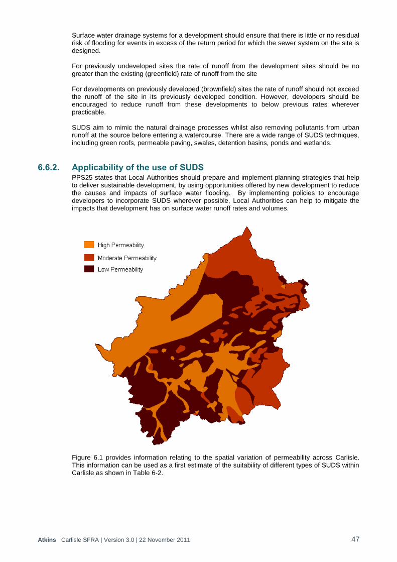
Atkins Carlisle SFRA | Version 3.0 | 22 November 2011 47
Surface water drainage systems for a development should ensure that there is little or no residual risk of flooding for events in excess of the return period for which the sewer system on the site is designed. For previously undeveloped sites the rate of runoff from the development sites should be no greater than the existing (greenfield) rate of runoff from the site For developments on previously developed (brownfield) sites the rate of runoff should not exceed the runoff of the site in its previously developed condition. However, developers should be encouraged to reduce runoff from these developments to below previous rates wherever practicable. SUDS aim to mimic the natural drainage processes whilst also removing pollutants from urban runoff at the source before entering a watercourse. There are a wide range of SUDS techniques, including green roofs, permeable paving, swales, detention basins, ponds and wetlands.
6.6.2. Applicability of the use of SUDS PPS25 states that Local Authorities should prepare and implement planning strategies that help to deliver sustainable development, by using opportunities offered by new development to reduce the causes and impacts of surface water flooding. By implementing policies to encourage developers to incorporate SUDS wherever possible, Local Authorities can help to mitigate the impacts that development has on surface water runoff rates and volumes.
Figure 6.1 provides information relating to the spatial variation of permeability across Carlisle. This information can be used as a first estimate of the suitability of different types of SUDS within Carlisle as shown in Table 6-2.
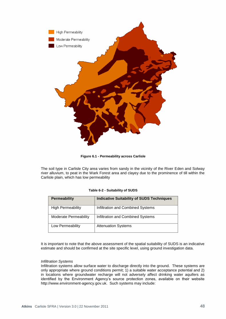
Atkins Carlisle SFRA | Version 3.0 | 22 November 2011 48
Figure 6.1 - Permeability across Carlisle
The soil type in Carlisle City area varies from sandy in the vicinity of the River Eden and Solway river alluvium, to peat in the Wark Forest area and clayey due to the prominence of till within the Carlisle plain, which has low permeability
Table 6-2 - Suitability of SUDS
Permeability Indicative Suitability of SUDS Techniques
High Permeability Infiltration and Combined Systems
Moderate Permeability Infiltration and Combined Systems
Low Permeability Attenuation Systems
It is important to note that the above assessment of the spatial suitability of SUDS is an indicative estimate and should be confirmed at the site specific level, using ground investigation data.
Infiltration Systems Infiltration systems allow surface water to discharge directly into the ground. These systems are only appropriate where ground conditions permit; 1) a suitable water acceptance potential and 2) in locations where groundwater recharge will not adversely affect drinking water aquifers as identified by the Environment Agency‟s source protection zones, available on their website http://www.environment-agency.gov.uk. Such systems may include:

Atkins Carlisle SFRA | Version 3.0 | 22 November 2011 49
Permeable surfaces o Gravel o Permeable Paving o Block Paving with voids o Grassed areas
Sub Surface Infiltration o Filter Drains o Geocellular Systems o Soakaways
Attenuation Systems If ground conditions cannot support infiltration systems, surface water may need to be attenuated using measures to store surface water. Attenuation systems, if designed at ground level, have the potential to take up large areas of development sites. Early consideration of such constraints is therefore essential. Attenuation systems may include:
Landscaped o Detention Basins o Balancing Ponds o Retention Ponds o Wetlands o Lagoons
Engineered o Underground Tanks o Ornate Water Features o Rainwater Harvesting o Green Roofs o Oversized Pipes
Combined Systems SUDS designs for most sites can include a combination of infiltration and attenuation systems and they have been categorised above according to the dominant process. Other forms of SUDS which can provide more balanced benefits of infiltration and attenuation include:
Swales
Filter Strips

Atkins Carlisle SFRA | Version 3.0 | 22 November 2011 50
7. Conclusions and Recommendations
7.1. Conclusions 1. This SFRA Report provides an overview of the planning context in relation to flood risk and
development within Carlisle. Flood risk is considered within each of the tiers of planning policy; nationally within the Planning Policy Statements and locally within the LDF.
2. Data has been collected through consultation with Carlisle City Council, Cumbria County Council, Environment Agency and United Utilities. The data collected has provided information on all sources of flood risk, flood defences, flood warning, land allocations, geology and topography.
3. The primary source of flood risk in Carlisle is fluvial flooding. Carlisle City is vulnerable from
the River Eden, River Petteril and the River Caldew, both independently and, in wider flood events, concurrently.
4. Carlisle is also at risk from flooding from sewers, surface water, reservoir breach and
groundwater rise.
5. Flood defence embankments are in place along the River Eden, River Petteril and the River Caldew. The flood defences have been recently constructed following the flooding in January 2005 and they provide protection from flooding up to an annual probability of 0.5%.
6. In addition to the formal defences there are numerous informal defences in private
ownership, where responsibility for maintenance lies with the riparian owner and the standard of protection and maintenance regimes are unknown.
7. In addition to flood defences to reduce the probability of flooding, flood warning has been in
operation in the Eden catchment for a number of years as a means of reducing the impacts of flooding. Flood Warning is provided on the River Eden, River Caldew, River Petteril and the Little Caldew. In addition, Carlisle is covered by general early alerts to possible flooding, known as Flood Alerts.
8. Climate change is expected to have an influence on future flood risk. The expectations are
that winter floods will happen more often and in urban areas flooding from thunderstorms will be more regular and more severe. Climate change has an impact on the number of properties at risk within Carlisle and in particular on the depth of flooding.
9. Breach analysis of the flood defences protecting property within Caldewgate/Shaddongate,
Denton Holme, Milbourne Street, Rickergate and Willowholme has been undertaken to assess the residual flood risk and flood hazards. There is a moderate or significant flood hazard in terms of depth and velocity in Denton Holme, Rickergate and Willowholme but within Caldewgate/Shaddongate and Milbourne Street the depth of flood water and velocities are much lower and the flood hazard is considered to be low.
10. The majority of the flood defences within Carlisle have a standard of protection of 0.5% AEP
(20 year) so these flood defences will only be overtopped for a 0.1% AEP event and out of bank flow will occur in a manner almost as if no defences existed.
11. A Flood Risk Vulnerability Classification has been undertaken to inform the Sequential Test
approach for the potential development sites identified within the Carlisle Strategic Housing Land Availability Assessment and the Employment Sites Study.
12. In total, there are 283 potential development sites within the District Boundary. 197 of these
sites are identified to fall within Flood Zone 1 „Low Probability‟ and therefore all uses of land/development types would be appropriate. However for developments on sites of 1 Ha or larger a site-specific Flood Risk Assessment is required.
Atkins Carlisle SFRA | Version 3.0 | 22 November 2011 51
13. Sixteen sites are identified to be within Flood Zone 2 „Medium Probability‟. Water Compatible, Less Vulnerable, More Vulnerable and Essential Infrastructure are appropriate within this Zone. All development proposals within Flood Zone 2 require a Flood Risk Assessment.
14. The remaining 70 sites are all identified to fall within Flood Zone 3, of which 65 are within
Flood Zone 3a „High Probability‟ and the remaining 5 within Flood Zone 3b „Functional Floodplain‟. In Zone 3a Less Vulnerable and Water Compatible uses are deemed appropriate. More Vulnerable and Essential Infrastructure require the Exception Test to be passed and Highly Vulnerable development should not be permitted. In Zone 3b only Water Compatible uses are deemed appropriate. Essential Infrastructure requires the Exception Test to be passed. All other uses should not be permitted.
15. Proposed development for “windfall sites” will by definition not derive from any potential
development sites that have been sequentially tested as part of this SFRA. The Sequential Test will need to be carried out for windfall sites and, if necessary, the Exception Test at the planning application stage.
16. Mitigation measures for future development within Carlisle can include measures that reduce
the physical hazard, e.g. through raised defences or flood storage; measures that reduce the exposure to the hazard, e.g. raise properties above flood levels or measures that reduce the vulnerability to the hazard, e.g. flood warning or emergency planning.
17. Surface water drainage systems for a development should ensure that there is little or no
residual risk of flooding for events in excess of the return period for which the sewer system on the site is designed. For previously undeveloped sites the rate of runoff from the development sites should be no greater than the existing (greenfield) rate of runoff from the site. For developments on previously developed (brownfield) sites the rate of runoff should not exceed the runoff of the site in its previously developed condition. However, developers should be encouraged to reduce runoff from these developments to below previous rates wherever practicable.
18. The permeability of the soil within Carlisle is mainly low with some small areas or medium
and high permeability soils. The implementation of SUDS as part of developments is thus largely restricted to attenuation systems. However, the spatial suitability of SUDS is an indicative estimate and should be confirmed at the site specific level, using ground investigation data.
7.2. Recommendations 1. There is limited information available on sewer flooding and in particular whether flooding is a
result of limited capacity issues or localised blockages or sewerage infrastructure. Data should be made available by United Utilities in order for a more thorough assessment to be made of the risk to a particular development site.
2. There needs to be a consistency in how runoff from development is attenuated. Connecting new developments into the United Utilities drainage system is not sustainable as surface water sewers discharge into the watercourses. Developers should be encouraged to attenuate surface water runoff on the site so it does not put pressure on the existing drainage system or increase runoff into watercourses via the sewer network.
3. There is a need to assess whether there is any critical infrastructure, e.g. hospitals, emergency services, etc within the floodplain for emergency planning purposes and to ensure there is access and egress during a flood event.
4. There is a requirement to undertake breach modelling of the flood defences along the River
Eden and River Petteril for the Warwick Road area.
5. This SFRA does not replace the need for site specific flood risk assessments. A greater level of detail should be provided by these assessments with respect to flood risk and any protection afforded to the site, including from informal flood defences. Consideration should
Atkins Carlisle SFRA | Version 3.0 | 22 November 2011 52
be given to the proportion of the site located within specific PPS25 Flood Zones and the implications of this upon the development layout of the site. This process will allow planning of sites to place higher vulnerability uses within lower risk areas. Where required, the site specific FRA will form part c) of the Exception Test. Site specific FRAs are required for all sites over 1 hectare in size and for all sites located with Flood Zones 2, 3a and 3b.
6. The SFRA has been produced based on current understanding of flood risk and existing and available flood risk information. In time, as Environment Agency studies are completed and further flood risk understanding is developed the information within this document will become outdated, Therefore, it is important that the SFRA is reviewed and updated at regular intervals to incorporate this information.

Atkins Carlisle SFRA | Version 3.0 | 22 November 2011
Appendices
Atkins Carlisle SFRA | Version 3.0 | 22 November 2011
Appendix A. Figures
Figure A.1 – Historical Flood Outlines
Figure A.2 – Potential Development Sites
Figure A.3 – Flood Zone Outlines
Figure A.4 – Sewer Flood Risk
Figure A.5 – Groundwater Flood Risk
Figure A.6 – Reservoir Breach Flood Risk
Figure A.7 – Areas Susceptible to Surface Water Flood Risk
Figure A.8 – Flood Map for Surface Water
Figure A.9 – Flood Defences
Figure A.10 – Climate Change
Figure A.11 – Caldewgate/Shaddongate Breach Analysis
Figure A.12 – Denton Holme Breach Analysis
Figure A.13 – Milbourne Street Breach Analysis
Figure A.14 – Rickergate Breach Analysis
Figure A.15 – Willowholme Breach Analysis
Figure A.16 – Sequential Test

Atkins Carlisle SFRA | Version 3.0 | 22 November 2011
Appendix B. Potential Development Sites

Atkins Carlisle SFRA | Version 3.0 | 22 November 2011
Appendix C. Flood Mapping Methodology

Atkins Carlisle SFRA | Version 3.0 | 22 November 2011
Appendix D. Breach Analysis Methdology
Atkins Carlisle SFRA | Version 3.0 | 22 November 2011
Appendix E. Flood Risk Vulnerability Classification to inform the Sequential Test
Atkins Carlisle SFRA | Version 3.0 | 22 November 2011
Appendix F. Planning Guidance

Atkins Carlisle SFRA | Version 3.0 | 22 November 2011
Appendix G. Guidance Notes for Developers

© Atkins Ltd except where stated otherwise. The Atkins logo, „Carbon Critical Design‟ and the strapline „Plan Design Enable‟ are trademarks of Atkins Ltd.