h041203043058
TRANSCRIPT
IOSR Journal of Engineering (IOSRJEN) www.iosrjen.org ISSN (e): 2250-3021,
ISSN (p): 2278-8719
Vol. 04, Issue 12 (December 2014), ||V3|| PP 43-58
International organization of Scientific Research 43 | P a g e
Characterization of Aliwal North Hotspring in the Eastern Cape
Province of South Africa, using Magnetic, Electromagnetic and
Radiometric Methods
C. Baiyegunhi1, N. W. Mupandawana
1, T. L. Oloniniyi
2and O. Gwavava
1
1Department of Geology, Faculty of Science and Agriculture, University of Fort Hare, Private Bag X1314,
Alice, 5700, Eastern Cape Province, South Africa 2Department of Geology and Mining, Faculty of Natural and Applied Sciences, Nasarawa State University,
Keffi, Nasarawa State, Nigeria
ABSTRACT
Magnetic, electromagnetic and radiometric survey were conductedalong two profilelines that traverses Aliwal
North spa using two G-859SX portable cesium vapor magnetometer, EM34-3 terrain conductivity meter and a
RS-125 spectrometer, respectively. This was undertaken in order to characterise Aliwal North hot spring by
revealing magnetic signatures, buried conductive bodies and determine the concentration/relative abundance of
radioactive elements, like U, K and Th (in cpm, ppm and %). The magnetic result reveal signature with
amplitude of about 0.4 nT,which is inferred to be a real feature extending to depth. The EM result showsmajor
anomaly in the southeastern part of the studyarea. This anomaly is associated with rocks with highconductivity
and occurring to a depth of about 30 m through which the highly mineralized hot water could have migrated to
the surface. There is no traceable recent volcanic activity in the area and due to the deep seated faults in the
survey site, it was inferred that Aliwal thermal spring is of meteoric origin and the source of the heat is due to
the deep circulation along the major fault zones. The radiometric result reveals that thorium is the most
abundant radioelements with concentration that isless than the world average hazardous threshold (7.4 ppm).The
concentration of the radioactive elements is relatively low and acceptable for groundwater; however it could be
harmful to humans’health, as well as animals when exposed to the radiation or consumed over a long period of
time.
Keywords: Magnetic, electromagnetic, radiometric, hot spring, groundwater, Aliwal North
I. INTRODUCTION Groundwater is the major source of water in the Republic of South Africa especially in water-scarce
area such as Aliwal North where people fetch or get water from groundwater discharge points (springs). A total
of about 74 hot springs are known in South Africa (Figure 1; Table 1) cutting across the entire the country
(Yibaset al., 2011). The occurrences of these hot springs are not restricted to a particular geology but they are
usually seen in locations that has high rainfall as well as existence of deep crustal faulting. Yibaset al.(2011)
stated that, no exploration boreholes have been drilled in South Africa for the purpose of determining origin,
geothermal heat flow, and sourceas well as the circulation pattern of the source of heat. However,geothermal
heat flow has been measured from some boreholes that were drilled for other purposes. Presently, the maximum
measured surface temperature of the hot springs is seen at the Siloam hot spring which is about 70 . Thus
there is low possibility of generating electricity from hydrothermal source; however, research is still ongoing to
determine the possible alternative means of power generation.

Characterization Of Aliwal North Hotspring In The Eastern Cape Province Of South Africa, Using Magnetic,
International organization of Scientific Research 44 | P a g e
Figure1Map showing location of hot springs in the South Africa, neotectonic fault and the Eastern Cape
northern neotectonic belt (Madi, 2014).
Table 1 Distribution of hot springs and Boreholes per Province (Olivier et al., 2008)
Kent, 1949 Boekstein, 1998; Hoole, 2001
Province Springs BHs Total Developed
Western Cape 14 1 15 9
Northern Cape 4 - 4 1
Eastern Cape 10 3 13 2
KwaZulu-Natal 5 - 5 4
Free State 4 4 8 4
North-West - - - 1
Mpumalanga 13 - 13 3
Gauteng 1 - 1 1
Limpopo 23 1 24 10
Total 74 9 83 35
Aliwal North hot spring is associated with fractured and fault zones (Figure 1) through which the
dolerite dykes (groundwater localizers) intruded the sandstones of the Tarkastad Subgroup at about 180 Ma. The
spring is not well developed, it has a temperature of about 37 and mostly used for washing clothes, bathing
and medicinal purposes to cure rheumatism and other related diseases (Hartnady, 2005).Hobday (1978)
emphasized on the need of detailed geophysical investigations of contacts between the lithological subdivisions
of the Karoo Supergroup in order to characterize and ascertain the origin of the thermal springs in the Karoo
Supergroup.
Characterization Of Aliwal North Hotspring In The Eastern Cape Province Of South Africa, Using Magnetic,
International organization of Scientific Research 45 | P a g e
Recently, many of these contacts between the lithological subdivisions have been studied and
documented but some areas such as Ecca – Beaufort contact, Beaufort–Molteno contact, and Burgersdorp–
Molteno contact are still understudied or difficult to characterise in terms of origin and associated geological
structures of the thermal springs. The Molteno-Burgersdorp contact is believed to be defined by an
unconformity in which the deposition is preceded by an erosional period but Visseret al. (1984) proposed that
the Molteno – Burgersdorp contact is conformable, but no absolute date is known for the Burgersdorp and the
Molteno Formations.Aliwal North hot spring serves as a target for groundwater exploration, which makes
Aliwal North to be regarded as a potential source of groundwater since no detailed geophysical surveys have
been carried out previously in Aliwal North, the occurrence and movement of groundwater is unpredictable or
complicated.Therefore, it is very important to characterize Aliwal North spa as exploration targets using the
magnetic, electromagnetic and radiometric.
1.1 Location of the study area
Aliwal North spa is located in the town of Aliwal North which lies on the border between the Free
State and Eastern Cape Province of South Africa.The studyarea extends from longitudes 26o 42′ 52″E to 26
o 43′
06″ E and latitudes 30o 42′ 49″ S to 30
o 42′ 50″ S(Figure 2). The town covers an area of about 169580 km
2 with
a population of 6,906,200 people and geographically situated between the Western Cape and KwaZulu-Natal
province, the northern part leads to Bloemfontein through the General Hertzog Bridge and to the south-west, the
Kramberg raises to about 2,000 m above the sea level (Hartnady, 1985). The climatic condition of the Eastern
Cape is a mixture of the climatic condition of the Western Cape and KwaZulu-Natal, it which get very wet
gradually from the west to the east part of the province (Hartnady, 1985).
Figure 2Geological map showing the study area (Catuneanuand Elango, 2001).
1.2 General background
Aliwal North belongs to the Tarkastad Subgroup in the Beaufort Group which is a fluvial environment
(Figure 2; Table 2). The Beaufort Group is stratigraphically subdivided into the Adelaide and the Tarkastad
Subgroups (Johnson, 1976; Tordiffe, 1978; Visser and Dukas, 1979; SACS, 1980; Catuneanu and Elango,
2001). The Adelaide Subgroup forms the lower part of the Beaufort Group and consists of the Koonap,
Middleton and Balfour Formations. The Tarkastad Subgroup where the study area belongs; forms the upper part

Characterization Of Aliwal North Hotspring In The Eastern Cape Province Of South Africa, Using Magnetic,
International organization of Scientific Research 46 | P a g e
of the Beaufort Group and consists of the Katberg and Burgersdorp Formations which are restricted to the
southern margins of the Karoo Basin from south of Queenstown to north of Aliwal North (Rubidge, 1995;
Hancox and Rubidge, 2001).
Table 2 Lithostratigraphy of the Beaufort Group in the Eastern Cape Province of South Africa (After, Johnson et
al., 2006).
GROUP SUBGROUP FORMATION MEMBER LITHOLOGY DEPOSITIONAL
ENVIRONMENT
Tarkastad
Burgersdorp Mudstone,
Sandstone, Shale
Fluvial
Katberg Sandstone,
Mudstone, Shale
Palingkloof Mudstone,
Sandstone, Shale
Elandsberg Sandstone, Siltstone
Beaufort Balfour Barberskrans Sandstone, Khaki
Shale
Adelaide Daggaboersnek Shale, Sandstone,
Siltstone
Oudeberg Sandstone, Khaki
Shale
Middleton Shale, Sandstone,
Mudstone
Transitional
(Deltaic) Koonap Sandstone,
Mudstone
The Koonap Formation consists of alternating sequence of sandstone and mudstone. It is the base of the
Adelaide Subgroup in the lower vicinity of the Beaufort Group and has lithological variation similar to those of
the overlying Middleton and Balfour Formations. It has a total thickness of about 1300 m (Johnson, 1976;
SACS, 1980). The Middleton Formation has a maximum thickness of about 1500 m and consists predominantly
of mudstone with subordinate shale and sandstone (Johnson, 1976). It is essentially a non-marine and
siliciclastic succession that was deposited in meandering rivers and their extensive environments (flood plains,
lakes and ponds). The lithology of the overlying Balfour Formation is dominated by sandstone interbedded with
mudstones and it represent a fully succession of Late Permian - Early Triassic age. The total thickness of up to
2150 m was measured around the Fort Beaufort area (Johnson, 1976; SACS, 1980), but Visser and Dukas
(1979), working further west of the study area measured about 650 m, thus indicating thickening towards the
south east.
Generally, the prevailing climatic condition in South Africa is warm, thus a temperature of 25 is use
as standard in distinguishing between hot springs and cold springs (Yibas et al., 2011). According to Kent
(1949), South Africa’s spring is classified into warm (25- 37 ), hot or hyperthermic (38-50 ) and scalding
(50 ). It was earlier believed that highest flow rate is associated with the hottest spring, which is not always
true because no basis has been given for that (debateable). Hartnady (2005) disagree with the assumption that
the hottest springs are those with the highest flow rates. They explained that the occurrencethermal spring
temperaturereveals the relationship/interaction between advective and conductive movement of heat in the host
aquifer system.The aquifer permeability is the key factor since it controls the flow velocity which is proportional
to the heat rate; where the groundwater flow velocities/permeability are low and heat transport is dominantly
conductive. These conditionsusually result in low temperature of the spring (about 25 ). In rocks where the
permeability is high, with high flow velocities and advective transport of heat is dominant, it results in large
volume of circulating water leading to high temperature of the spring (38-50 ).The warmest springs usually
occur for an intermediate range of permeability which is the most common type of thermal springs in South
Africa (Aliwal North spa) with temperature of (25-37 ) and when the temperature of the thermal spring is very
high (> 50 ), it is referred to as a scalding thermal spring.
Geothermal springs can be used for different purposes but their uses depend on the temperature of the
thermal spring, flow rate, chemistry as well as other economic factors such as the accessibility to the thermal
spring, ownership of the resource, distance to a potential user, and environmental limitations. These determine
whether the thermal spring is suitable for either electric power generation or direct utilization such as direct

Characterization Of Aliwal North Hotspring In The Eastern Cape Province Of South Africa, Using Magnetic,
International organization of Scientific Research 47 | P a g e
heating of different forms, space heating leisure, spas, aquaculture, floriculture, green house and medicinal
purposes (cure rheumatism and related diseases).A thermal spring can experience changes in its features due to
local or regional events that affect the source or flow path, the heat source, thermal characteristics along the
subsurface flow path, weather pattern and the fractured rock through which the fluid moves to the surface. The
hot fluid may either come from a magmatic hydrothermal system or non-magmatic hydrothermal system. In
magmatic hydrothermal system, the rock is heated up by the magma which in turn heats up the deep circulating
water while in a non-magmatic hydrothermal system; the rock is heated by geothermal gradient which results in
thermal water and quickly return to the Earth's surface through the created fractures.Three main components are
required for the formation of a hydrothermal system. These include water, heat and permeability in which water
can flow to the surface or near the surface, the water that recharge the Aliwal spa is far (up to tens of kilometres)
from the discharge and got their source from rainfall, snowmelt, rivers, and lakes which form most of
hydrothermal fluids and reaches depth of several kilometres. Hydrothermal systems are found in different
geological environments such as hydrothermal vents, sedimentary basins, epithermal to magmatic-hydrothermal
ore-forming environments, this environment shows different chemical compositions and fluids flow path.
Donald et al. (1992) proposed that most hot springs in the world are linked with waning stages of
volcanic activity. There can be changes in thermal springfeatures due to local or regional events that affect the
source or flow path, the heat source, thermal characteristics along the subsurface flow path, weather pattern
(climatic change) and the fractured rock through which the fluid move to the surface. The hot fluid move
through fractures in the rock creating permeability, the pores may be interconnected allowing the flow of the
fluids which are recharged to the surface by the infiltration of rainwater or snowmelt and underground water
circulating near magma at great depth or driven by pressure or density giving rise to a spring.The hot fluid may
either be from a magmatic hydrothermal system or non-magmatic hydrothermal system. In magmatic
hydrothermal system, the rock is been heated up by the magma which in turn heat up the deep circulating waters
while in a non-magmatic hydrothermal system, the rock is heated by geothermal gradient (temperature with
depth) which results in thermal water and quickly return to the Earth's surface through the created fractures
(permeability).
II. MATERIALS AND METHODS Fieldwork was conducted over a period of time using three geophysical techniques that includes; the magnetic,
electromagnetic and radiometric method. The survey was carried out in an outer zone from the hot spring due to
the absence of outcrops, only one weathered greyish mudstones was seen outcropping to the surface. The three
geophysical methods wereemployedto allow comparison of the results and to increase the confidence or degree
of accuracy of the data since magnetic field dies out with time and the actual age can be determined using the
abundance of the radioactive elements obtained from the radiometric survey.
2.1Instrumentation and technique of magnetic survey at Aliwal North spa
The ground magnetic survey was conducted along two survey lines (L1 and L2) in Aliwal North Spa
using two G-859SX portable cesium vapor magnetometer (movable and non-movable magnetometer). The
magnetometer uses the Novatel Smart AntennaTM
GPS for capturing positions automatically while collecting
data in almost 5 different separate survey files, the non-volatile RAM of the magnetometer can record data for 8
to 12 hours at the maximum rate of 5 Hz and operate in the range of 17,000 nT to 100,000 nT, noise level of
(0.02 nT, gradient tolerance of 0.05 nT/inch (20,000 nT/m) and temperature drift of (0.005 nT/0C and sensitivity
of 0.03 nT at 0.2 sec cycle rate. The non-movable magnetometer was mounted in a quiet place within the survey
area (base station) to monitor diurnal variations and the movable magnetometer was carried by the operator,
which takes the total magnetic field as the operator walks along the survey lines (L1 and L2). The movable G-
859SX portable cesium vapor magnetometer was set up in way that it takes reading at every 2sec, mounted on
the operator as depicted in Figure 3 and measurements commenced along lines (L1 and L2). At the end of the
survey, the stored data was processed and downloaded into the laptop with the use of MagMap 2000 software to
allow for further data processing/reduction.

Characterization Of Aliwal North Hotspring In The Eastern Cape Province Of South Africa, Using Magnetic,
International organization of Scientific Research 48 | P a g e
Figure 3 Magnetic survey using G-859SX portable caesium vapor magnetometer.
2.2 Instrumentation and technique of electromagnetic survey at Aliwal North spa
The instrument used for electromagnetic survey is the EM34-3 terrain conductivity meter.It consists of
a transmitter and a receiver coil that works with different frequencies (0.4 kHz, 1.6 kHz and 6.4 kHz), using a
self-contained dipole transmitter as the source and a self-contained dipole receiver as a sensor with a
measurement accuracy of ± 5 % at 20 mS/m. The instrument noise level is less than 0.2mS/m and can operate in
the temperature range of -400C to +50
0C. The survey was carried out along the survey lines using three coil
spacing of 10 m, 20 m, and 40 m since the depth of exploration depend on the coil spacing (transmitter and
receiver) and the orientation of the coils. The horizontal mode (vertical coplanar) was measured for Line 1 and
Line 2 using 10 m, 20 m, and 40 m coil spacing, respectively (see Figure 4). The EM34-3 is very sensitive to
both vertical and horizontal geological anomalies and works with a frequency of 6.4 kHz at 10 m coil
separation, 1.6 kHz at 20 m coil separation and 0.4 kHz at coil spacing of 40 m. The EM34-3 terrain
conductivity meter was used to measure the apparent conductivity of the ground in milliSiemens/meter (mS/m).
The survey was performed by three operators, the first operator carried the transmitting coil, transmitter and
hold the start point or edge (tip) of the wire (40 m), the second operator carried the receiving coil, receiver, and
the end point or edge (the other tip) of the wire (40 m), and the third operator carried a GARMIN-10 GPS, a
field notebook for recording the GPS location, the conductivity value on the receiver at every station (e.g. 40 m)
which is the distance between the first operator (transmitter) and the second operator (receiver). The technique
used is called the "stop and go" and it takes a rectangular shape, the measurements start along a line and end
along a line that intersects the start line. To start taking the measurement, the first operator with the transmitter
and a coil stands at the starting point and the second operator with the receiver and the second coil stand 40 m
away from the transmitter along the base line, both the transmitter and the receiver are switched on and the coil
is aligned (vertically) to each other such that an electromagnetic field is generated and received by the
receiver.The measurement is taken after balancing the receiver on the graduation of the measuring meter,
reading is taken and recorded at every 40 m, the GPS value at the point is also taken and recorded, then the first
operator carrying the transmitter and the transmitting coil now move to the point where the receiver was before
which is 40 m away from the start point, and the second operator carrying the receiver and the receiving coil
now move 40 m further away along the line and both the transmitting and the receiving coils are aligned
(vertically) to each other and the reading was taken from the receiver and recorded, the GPS value was also
taken and recorded. The procedure as above was carried out and recorded when the distance between the
transmitter and receiver were 10 m and 20 m, respectively.

Characterization Of Aliwal North Hotspring In The Eastern Cape Province Of South Africa, Using Magnetic,
International organization of Scientific Research 49 | P a g e
Figure 4 Electromagnetic survey using EM34-3 terrain conductivity meter.
2.3 Instrumentation and technique of gamma ray survey at Aliwal North spa
The portable RS-125gamma ray spectrometer was used to determine the spatial distribution of three
radioactive elements (potassium-K, thorium-Th and uranium-U)at Aliwal North spa. It consists of a detector and
analyser, the detector detects or senses gamma rays while the analyser analyses the signal and displays the
result, The spectrometer uses a Sodium-Iodide crystal to detect the radioactive elements (K, U, and Th) with an
integrated spectrometer system that measures the total amount of the incoming gamma radiation which lies
above a particular energy threshold and present the data used for analysis. The survey mode, scan mode, and
assay mode are the three operational mode buttons on the spectrometer, which can be easily identify and press
by the operator, the assay mode was used for the survey and it givesthe concentration of the radioactive
elements in percentage (%), parts per million (ppm) and counts per million (cpm). The RS-125 gamma
spectrometer uses an externalGPS that is connected via bluetooth to automatically capture locations at each
reading and stabilizes automatically on the natural occurring radioactive elements (K, U and Th). The
instrument takes reading every 11 seconds and can operate in a range of temperatures between -20 0C to +50
0C.The RS-125 gamma ray spectrometer was set up and mounted in the same manner as the magnetic method
(Figure 4).
2.4 Data processing and retrieval
Data processing and retrieving was done with the use of MagMap 2000 software, it analyses and
process the data from the geophysical instrument (magnetometer, RS-125 spectrometer and EM34-4) and allows
for positional modification on the survey data. The operator created a STN file and selected the ASCII data
download using RS-232 with MagMap 2000. The downloaded binary data was stored in a binary file with the
extension BIN on the laptop. The downloaded file was unzipped using the WinZip software. The created file
was viewed from an ASCII text editing program by excel spreadsheet and the same downloading procedure was
used to retrieve the electromagnetic and radiometric field data.
2.5 Radiometric ternary image
A ternary radiometric image was plotted using the four grid channels from Oasis Montaj, which
includes; the potassium, uranium, thorium and the total count. Three apexes were used to depict compositions of
uranium (yellow), potassium (blue) and thorium (red) and allows comparison between uranium, potassium and
thorium at once, every position or point on the ternary plot represents a different composition of the three
elements. The radiometric ternary image also assists in distinguishing between different lithologies as shown by
variations in colour which is due to the different mineral abundances of potassium, uranium and
thorium.Distinguishing between the different lithologies may be difficult when image becomes saturated (all
abundances are relatively high) and where images becomes very dark, which is believed to be due to low
abundances of the radioactive elements, the sum of the variables (elements) is taken to be a constant which is
represented as 1.0 or 100%. Element ratio maps were also produced i.e. K/K+U+Th, U/K+U+Th, Th/K+U+Th.

Characterization Of Aliwal North Hotspring In The Eastern Cape Province Of South Africa, Using Magnetic,
International organization of Scientific Research 50 | P a g e
III. RESULTS AND DISCUSSION
Figure 5 Total magnetic field map of Aliwal North spa. Two main areas of high magnetic field are seen in the
map and they both lie along Line 2 (B - B’) and falls within 3399400 E to 3399500 E and 27150 S to 27250 S
on the magnetic map.
Figure 6 Profile for total magnetic field for Line 1 and Line 2.
Figure 6 shows a total magnetic field of 27215.3 nT on the northwestern side of the survey site along
Line 1 (A – A’) which remains constant for a distance of about 85 m and thereafter decreases slowly to a value
of 27214.9 nT at the end of the line. The magnetic field along Line 2 (B – B’) in the northwestern side of the
map is about 27215.03 nTand decreases gradually to 27214.9 nT at a distance of about 85 m.It increases
continuously from 27214.9 nT at a distance of 85 m until a peak of 27215.28 nT was reached at a distance of
about 130 m, then decreases gradually to 27215.02 nT at a distance of about 190 m and further increases
continuously until a total magnetic field of 27215.3 nT was reached at the end of the line. The observed anomaly
along Line 2 (B – B’) with amplitude of about0.4 nT could be a real feature extending to depth. No discernable
contrast was observed on the Line 1 (A – A’).
Characterization Of Aliwal North Hotspring In The Eastern Cape Province Of South Africa, Using Magnetic,
International organization of Scientific Research 51 | P a g e
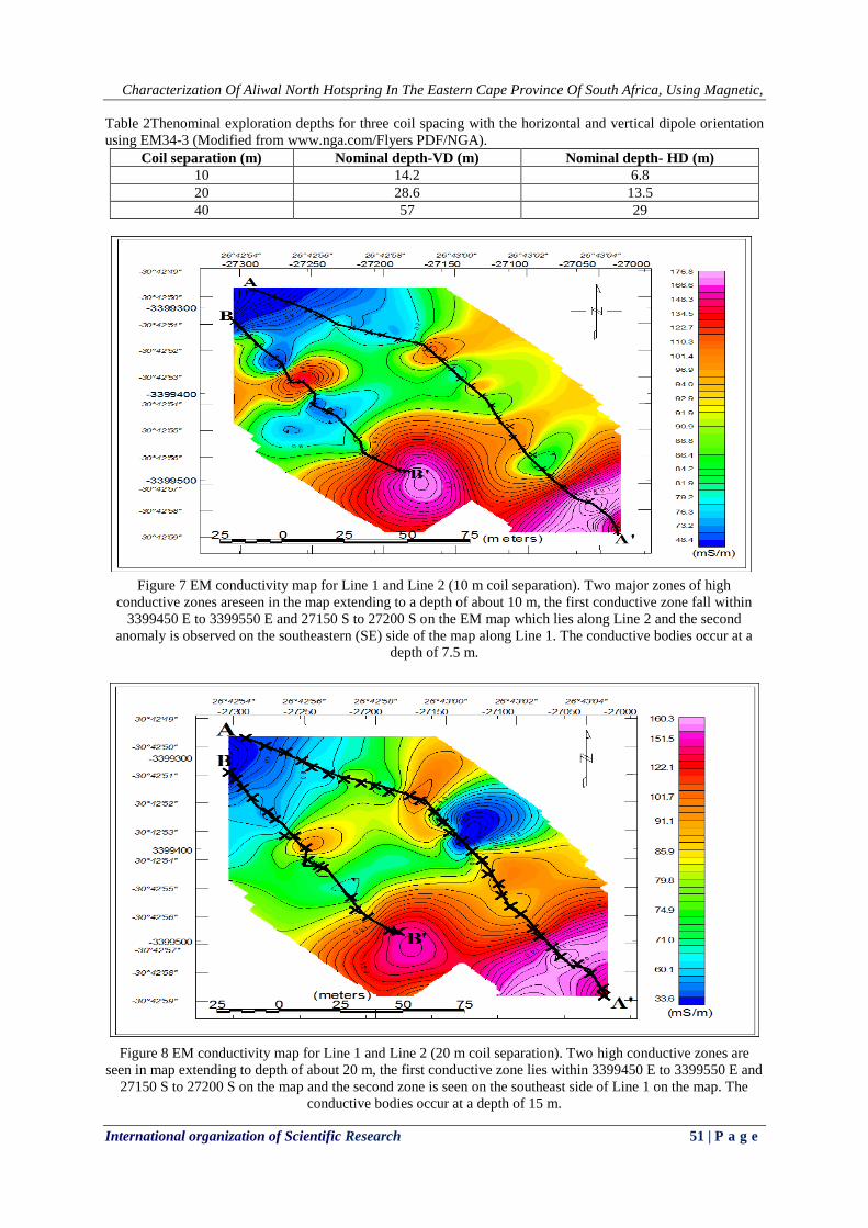
Table 2Thenominal exploration depths for three coil spacing with the horizontal and vertical dipole orientation
using EM34-3 (Modified from www.nga.com/Flyers PDF/NGA).
Coil separation (m) Nominal depth-VD (m) Nominal depth- HD (m)
10 14.2 6.8
20 28.6 13.5
40 57 29
Figure 7 EM conductivity map for Line 1 and Line 2 (10 m coil separation). Two major zones of high
conductive zones areseen in the map extending to a depth of about 10 m, the first conductive zone fall within
3399450 E to 3399550 E and 27150 S to 27200 S on the EM map which lies along Line 2 and the second
anomaly is observed on the southeastern (SE) side of the map along Line 1. The conductive bodies occur at a
depth of 7.5 m.
Figure 8 EM conductivity map for Line 1 and Line 2 (20 m coil separation). Two high conductive zones are
seen in map extending to depth of about 20 m, the first conductive zone lies within 3399450 E to 3399550 E and
27150 S to 27200 S on the map and the second zone is seen on the southeast side of Line 1 on the map. The
conductive bodies occur at a depth of 15 m.

Characterization Of Aliwal North Hotspring In The Eastern Cape Province Of South Africa, Using Magnetic,
International organization of Scientific Research 52 | P a g e
Figure 9 EM conductivity map for Line 1 and Line 2 (40 m coil separation). Three high conductive zones is seen
in the map extending to a depth of about 30 m, the first conductive zone lies within 3399300 E to 3399350 E
and 27150 S to 27200 S, the second anomaly occurs within 3399450 E to 3399550 E and 27150 S to 27200 S
and the third anomaly lies in the southeastern part of the map. The first and second anomalies were along Line 2
while the third anomaly falls on Line 1.
Figure 10 EM combined profiles for Line 1 (10 m, 20 m and 40 m coil separation).
Figure 10 shows two main conductive zones along Line 1 (A –A’), the first anomaly was picked up
using the 40 m coil separation which indicates that a conductive body occur at a depth of about 30 m in the

Characterization Of Aliwal North Hotspring In The Eastern Cape Province Of South Africa, Using Magnetic,
International organization of Scientific Research 53 | P a g e
ground between distances of 55 m to 110 m but disappears at shallow depth (7.5 m). The conductive body that
was picked up using the 10 m and 20 m coil separations (55 m to 110 m) could be due to near surface effect.
The second conductive body was picked up using the 10 m, 20 m and 40 m coil separations between distance of
about 300 m to 423 m, indicating that the conductive body occur at shallow depth (7.5m) and extends to deeper
depth (30 m). This body could be dolerite intrusion occurring at depth with associated faulting.
Figure 11 EM combined profiles for Line 2 (10 m, 20 m and 40 m coil separation).
Figure 11 shows that an anomaly (conductive body) was picked up using the 10 m, 20 m and 40 m coil
separation between the distance of 190 m to 223 m, this conductive body is not just due to near surface effects
like overburden but continues to a depth of up to 30 m into the ground. The second conductive body was picked
up using the 10 m and 20 m coil separation between the distances of about 57 m to 120 m. This conductive body
occurs up to a depth of 15 m but disappears at 30 m which could be due to near the surface effect.
Table 2Classification for radioactive elements measurement (Baiyegunhi, 2012).
Measurements Low Moderate High Very high
Dose count (nSv/hr) ≤ 19 20-39 40-59 ≥60
Relative Abundance (%) ≤19 20-39 40-59 ≥60
Count (cpm) ≤19 20-39 40-59 ≥60
Count (ppm) ≤0.10 0.11-0.79 0.8-1.49 ≥1.5
Figure 12 Total count map, also showing profile Line 1 and Line 2.Line 1 cut the high total count zone in the
southeastern side and the high total count zone in the northwestern side of the map was slightly cuts by both
Line 1 and 2.
Characterization Of Aliwal North Hotspring In The Eastern Cape Province Of South Africa, Using Magnetic,
International organization of Scientific Research 54 | P a g e
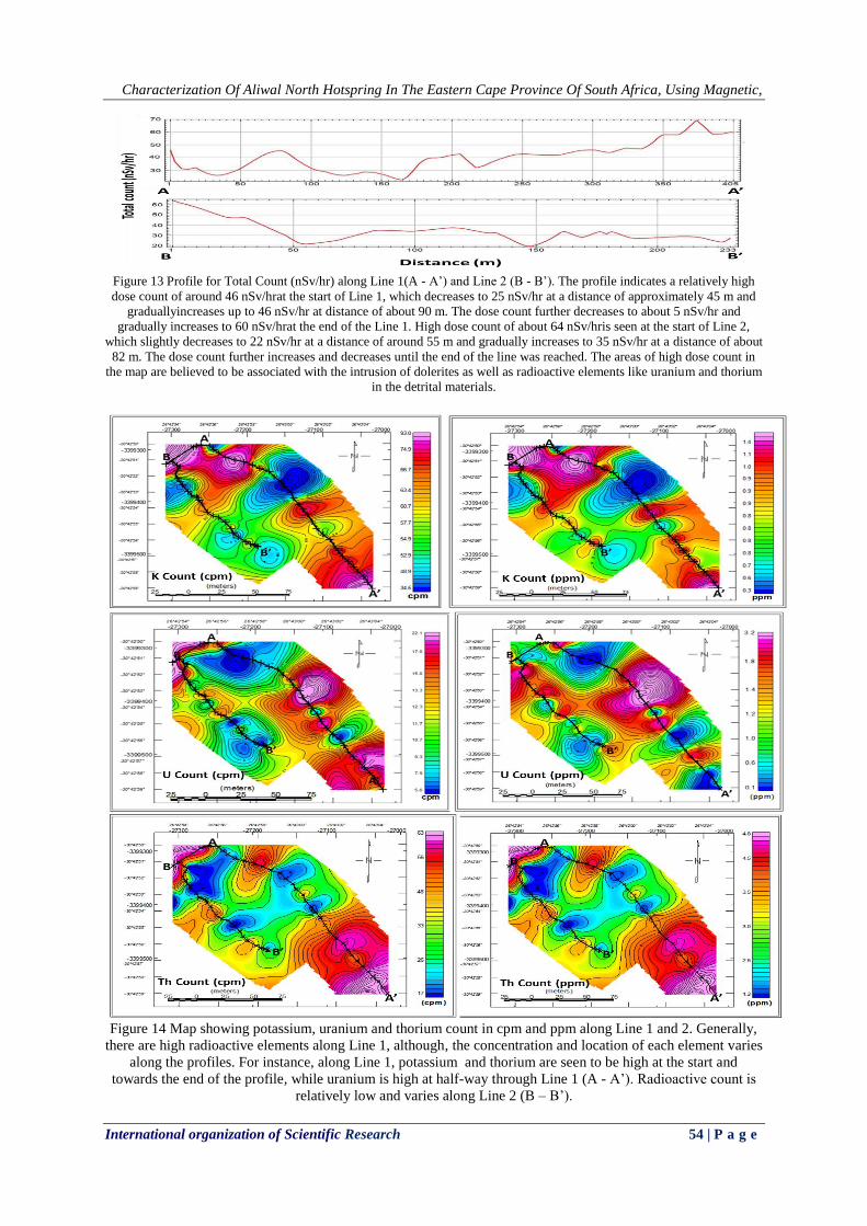
Figure 13 Profile for Total Count (nSv/hr) along Line 1(A - A’) and Line 2 (B - B’). The profile indicates a relatively high
dose count of around 46 nSv/hrat the start of Line 1, which decreases to 25 nSv/hr at a distance of approximately 45 m and
graduallyincreases up to 46 nSv/hr at distance of about 90 m. The dose count further decreases to about 5 nSv/hr and
gradually increases to 60 nSv/hrat the end of the Line 1. High dose count of about 64 nSv/hris seen at the start of Line 2,
which slightly decreases to 22 nSv/hr at a distance of around 55 m and gradually increases to 35 nSv/hr at a distance of about
82 m. The dose count further increases and decreases until the end of the line was reached. The areas of high dose count in
the map are believed to be associated with the intrusion of dolerites as well as radioactive elements like uranium and thorium
in the detrital materials.
Figure 14 Map showing potassium, uranium and thorium count in cpm and ppm along Line 1 and 2. Generally,
there are high radioactive elements along Line 1, although, the concentration and location of each element varies
along the profiles. For instance, along Line 1, potassium and thorium are seen to be high at the start and
towards the end of the profile, while uranium is high at half-way through Line 1 (A - A’). Radioactive count is
relatively low and varies along Line 2 (B – B’).

Characterization Of Aliwal North Hotspring In The Eastern Cape Province Of South Africa, Using Magnetic,
International organization of Scientific Research 55 | P a g e
Figure 15 Ternary diagram and relative abundance of potassium, uranium and thorium.
Generally, there is high abundance of radioactive elements (U,K and Th) along Line 1. Figure 15
shows that the northwestern side of the survey site is enriched in thorium (dominant in the southeastern side).
Uranium is more prominent in northeastern part, while potassium is more in the northwest part in contact with
the thorium. The ternary image shows NW- SE trending linear feature underlying the survey site which could be
the source of other minor trends in the area, this linear trends are assumed to be faultingthat is associated with
the intrusion of the Karoo dolerites. From the ternary diagram, it can be inferred that thorium is the most
abundance radioelements in the study area.
Figure 16 Interpretation map for Line 1 and Line 2.
Figure 16 shows that the EM and gamma ray anomaly between the distances of 300 m to 420 m along
Line 1 in the southeastern part of the map, and they both coincide or agree. This anomaly is the major anomaly
in the survey area which occurs at shallow depth, as well as extends to depth of about 30 m.It is suggested that
the anomaly might be dolerite intrusions at depthwith associated faulting. The EM and gamma ray anomaly also

Characterization Of Aliwal North Hotspring In The Eastern Cape Province Of South Africa, Using Magnetic,
International organization of Scientific Research 56 | P a g e
agrees in the north-northwestern side of the map along Line 1 between the distances of 50 m to 120 m, although
this anomaly occurs to a depth of about 30 m but disappears at shallow depth. The magnetic, EM and gamma
ray survey anomaly coincides along Line 2 within 180 m to 233 m and occur at a depth of 30 m. The second
anomaly was picked between the distance of 50 m to 120 m by the magnetic and gamma ray survey, this
anomaly that appears at shallow depth and disappears at greater depth could be due to near surface effects.
The magnetic data for Line 1 shows no discernable contrast while that for Line 2 shows a relatively
low amplitude or change in the magnetic field with amplitude of about 0.4 nT, which could be a real feature
possibly at great depth.
The combined EM resultalong Line 1 (Figure 10) signifiesthe existence of conductive body between
the distances of about 330 m to 408 m. This buried body was picked up when using 10 m and 20 m coil
separations indicating that the body is not just due to near surface material effect but extends deeper, which
could possibly be due dolerites in the form of sills and dykes at depth. The 40 m coil separation also picked a
conductive body that occurs at a nominal depth of about 30 m in the ground between a distance of 60 m to 120
m (along Line 1) which disappears at a distance of about 215 m, another conductive body at a distance of 330 m
to 374 m was detected which coincides with the conductive body that was picked up by the 10 m and 20 m coil
separation, respectively. The EM combined results (Figure 11) along Line 2 shows a conductivebodythat was
picked up when using the 10 m and 20 m coil separations indicating that the conductive body is not just due to
near surface effect like overburden but continues to a nominal depth of up to 15 m. The 40 m coil separation
also indicates that the conductive body continues to a depth of about 30 m into the ground.The gamma ray
results indicate a high concentration of the three radioactive elements (K, U, and Th) in the Aliwal North spa.
The high concentration of these radioactive elements could be due to high radioactivity which may be associated
with the intrusions such as dolerite dykes along the fractured and fault zones.
The presence of hot springs in a locality, such as Aliwal North can be linked to the presence of deep
structures, neotectonic zones (e.g. fault-zones) that provide support to the circulation of convectional currents as
well as artesian systems (Kent, 1969).Presently, three neotectonic belts (southern, eastern and northern belts)
aredocumented in the Eastern Cape Province (Figure 2). From the rocks of the Cape Fold Belt, the southern
neotectonic belt extends to the rocks of the Adelaide Subgroup in the Beaufort Group (Madi, 2013). Madi
(2013) further explained that, out of the twelve (12) hot springs situated in the Eastern Cape, seven (7) of hot
springs are located within the northern neotectonic belt. The existence of the seven (7) hot springs in
neotectonics zone also agrees with the suggestion that hot springs are possible indicator of neotectonics. Based
on this explanation, Maud et al. (1983) concluded that the 1983 basaltic eruption in Lesotho can be attributed to
ascension or upwelling of magma in the area that led to the heating of the underneath water.
Uranium deposits in the Karoo Supergroup are confined to fluvially-deposited sandstones in the
Adelaide Subgroup. Cole and Wipplinger (2001) stated that the absence of uranium in lithologies of similar
disposition in terms of depositional environment (paleoclimate and palaeoenvironments) is probably due to the
absence or lack of a suitable uranium source at the time of metallogenesis. Basement granite has been proposed
as possible uranium sources for the Adelaide and Tarkastad Subgroups. The warm, semi-arid paleoclimate of all
these stratigraphic units (Beaufort Group) signifies an oxidising environment, which is required for the leaching
and mobilisation of uranium from the above sources. Solutions containing radioactive elements like uranium-
bearing solutions probably migrated through the sand bodies with precipitation occurring in relatively sparse
reduced zones that contained carbonaceous debristhat are deposited in the Aliwal North hot spring.The
radiometric result reveals that thorium is the most abundant in the study area and their concentration is less than
the world average hazardous threshold (7.4 ppm). This result also agrees with the work of several authors
(e.g.Hartnady, 1985;Oliveret al., 2011; Madi, 2010; 2014) that study the hot springs in the South Africa. They
alludes that the concentration of the radioactive elements (U, K and Th) is relatively low and acceptable for
groundwater (hot springs) consumption based on the concentration of radioactive elements; however, it could be
harmful to humans’ health, as well as animals when exposed to the radiation or consumed over a long period of
time.
IV. CONCLUSIONS
Based on the results presented in this paper, the following conclusions are made:
Most of the anomalies are suggested to be dolerite intrusion with associated faulting that runs in a south-
westerly to north-easterly direction, although few anomalies show south-easterly to north-westerly
direction.
The results for EM Line 1 and Line 2 where high conductivity bodies (≥ 80 mS/m) were detected could be
due to the intrusions such as dolerite dykes along the fractured and fault zones, while moderate (65 - 79
mS/m)and low (≤ 64 mS/m) conductivities areas may be related to near surface mineralization in the
argillaceous sedimentary rocks (red mudstone, light grey sandstone and grey shale) of the Tarkastad
Subgroup which was intruded by the dolerite dykes.

Characterization Of Aliwal North Hotspring In The Eastern Cape Province Of South Africa, Using Magnetic,
International organization of Scientific Research 57 | P a g e
It was inferred that Aliwal hot spring is of meteoric origin and the source of the heat is due to the deep
circulation along the major fault zones through which the water percolates into the ground and gets to a
deeper depth.
The radiometric ternary and relative abundance maps reveal that thorium is the most abundant radioactive
element in the area.
From the gamma radiation count maps (cpm and ppm), it could be deduced that region with high gamma
radiation count could be due to the uranium and thorium in the detrital material, as well as the accumulation
of radioelements in the sediments of the Tarkastad Subgroup that are rich in feldspars (K-feldspar) with
calcite, quartz and clay minerals. The radioactive elementsare believed to be sourced from the fluvial
sandstone, surrounding shales and probably the Precambrian basement granites.
It is recommended that detailed geological mapping and geophysical surveys with a reduced line
spacing (5 m) should be carried out to determine the extent and concentration of the minerals present in the area
whereby the full economic potential of Aliwal thermal spring can be achieved, which could be a substantial
economic contribution to the local area and the country's economy at large. It is also recommended that a
regular geochemical sampling and analysis should be carried out on the water samples and the responsible
authorities should be informed of the potential health hazards that are related to the long-term consumption of
the untreated thermal water which may contain dissolved minerals and the general public in the area should be
alert of the risks, control and treatment measures. It is strongly recommended that substitute or alternative
source of portable water should be provided and the thermal spring environmental and economic potentials
should be maximised.
V. CONFLICT OF INTERESTS The authors declare that there is no conflict of interestsregarding the publication of this paper.
VI. ACKNOWLEDGMENTS The authors thank Govan Mbeki Research and Development Centre (GMRDC) for supervisory link
bursary. Mr PeterNyabeze and Mr MatomeSekibi of theCouncil for Geoscience are kindly appreciated for the
logistics as well as providing geophysical instruments for the field work.
REFERENCES [1] Adele, M., (1994). Geophysical methods in geothermal exploration. Italian National Research Council International Institute for
Geothermal Research Pisa, Italy. [2] Baiyegunhi, C., (2012). Geophysical investigation of Aliwal North Spa in the Eastern Cape, South Africa. Honours Project,
University of Fort Hare. P.1-60.
[3] Boekstein, M., (1998). Hot Springs Holidays: Visitors’ Guide to Hot Springs and Mineral Spa Resorts in Southern Africa. Mark Boekstein and Logo Print, Cape Town.
[4] Catuneanu, O., and Elango, H.N., (2001). Tectonic control on fluvial styles: the Balfour Formation of the Karoo Basin, South
Africa. Sedimentary Geology. vol. 140, p. 291- 313. [5] Cole, D.I. and Wipplinger, P.E., (2001). Sedimentology and molybdenum potential of theBeaufort in the main Karoo Basin,
South Africa. Memoir, Council for Geoscience, vol. 80, p 1-225.
[6] Donald B., Douglas P. K., and David C. C., (1992). Geophysical methods in exploration and mineral environmental
investigations. Society of Exploration Geophysicists. p. 1-9.
[7] EM34-3 and EM34-3XL Operating instructions for model with two digital meters (2007). Geonics Limited.
[8] EM34-3 and EM34-3XL Operating Instructions (1994). Geonics Limited. [9] Hancox, P.J. and Rubidge, B.S., (2001). Breakthroughs in the biodiversity, biogeography,biostratigraphy and basin analysis of
the Beaufort Group. African Earth Sciences, vol. 33,p 563–577.
[10] Hardy, C. C., (2005). Characterizing thermal features from multi-spectral remote sensing data using dynamic calibration procedures [Ph.D. dissertation]: University of Montana at Missoula, p. 124-153.
[11] Hartnady, C.J. (1985). Uplift, faulting seismicity, thermal spring and possible incipient volcanic activity in the Lesotho-Natal
region, SE Africa: the Quathlamba hotspot hypothesis. Tectonics 4, p. 371-377. [12] Hobday, D.K., (1973). Middle Ecca deltaic deposits in the Muden-Tugela Ferry area of Natal. Transactional Geological Society
of South Africa, vol. 76, p 309-318.
[13] Johnson, M. R., (1976). Stratigraphy and sedimentology of the Cape and Karoo sequences in the Eastern Cape Province. PhD Thesis (unpublished), Department of Geology, Rhodes University, Grahamstown.
[14] Kent L. E., (1949).The thermal waters of the Union of South Africa and South West Africa. Trans. Geol. Soc. S. Afr. 52 231-
264. [15] Kent L. E., (1969). The thermal waters in the Republic of South Africa. In: Proc. Of Symposium II on mineral and thermal
waters of the world, B-overseas countries, Vol. 19, Report of the 23rd session of the International Geological Conference, 1968,
Academia, Prague, 143-164.Developments in Geophysical Exploration. Methods – 2. Applied Science Pub., p. 107-150. [16] Madi, K., (2010). Neotectonics and its applications for the exploration of groundwater in the fractured Karoo aquifers in the
Eastern Cape, South Africa. MSc thesis, University of Fort Hare. p. 12-160.
[17] Madi, K., Nyabeze P., Gwavava, O., Sekiba, M and Zhao, B., (2014). Uranium, thorium and potassium occurrences in the vicinity of hot springs in the northern neotectonic belt in the Eastern Cape Province, South Africa. J RadioanalNucl Chem.,
301:351–363. DOI 10.1007/s10967-014-3183-1.
[18] MagMap 2000 (24891-01 Rev. G). User Guide Geometrics Inc.

Characterization Of Aliwal North Hotspring In The Eastern Cape Province Of South Africa, Using Magnetic,
International organization of Scientific Research 58 | P a g e
[19] Maud, R., Partridge, T. C., and Dunleavy, J., (1998) The Lesotho ‘‘volcanic’’event of 1983. South Afr J Geol 101(4):313 [20] Olivier, J., Venter, J. S and Jonker, C. Z., (2008). Thermal and chemical characteristics of thermal springin the northern part of
the Limpopo Province, South Africa, Water SA 34 (2) 163-174.
[21] Oliver, J., Venter, J.S and Jonker, C.Z., (2011). Thermal and chemical characteristics of hot springs in the northern part of the Limpopo Province, South Africa. Available on line http://www.wrc.org.za
[22] Rubidge BS. (2005). Re-uniting lost continents – Fossil reptiles from the ancient Karoo and their wanderlust. S Afr J Geol.v.108,
p135–172. http://dx.doi.org/10.2113/108.1.135 [23] SACS, South African Committee for Stratigraphy, (1980). Stratigraphy of South Africa. Part 1: Lithostratigraphy of the Republic
of South Africa, South West Africa/Namibia and the Republics of Bophuthatswana, Transkei and Venda (Compiled by Kent,
L.E.). Geological Survey of South Africa. Handbook, 8, 690pp. [24] Scintrex, (1996). Magnetic Applications Guide. Scintrex Limited.
[25] Tordiffe, E. A. W., (1978). Aspects of the hydro-geochemistry of the Karoo Sequence in the Great Fish River Basin Eastern
Cape Province: With special reference to the groundwater quality. Ph.D. thesis (unpubl.). Univ. O.F.S., Bloemfontein, 307pp. [26] Visser, J.N.J. and Dukas, B.A., (1979). Upward fining fluviatile megacycles in the BeaufortGroup, north of Graaff-Reinet, Cape
Province. Trans. Geol. Soc. S. Afr., vol. 82, p 149-154.
[27] Visser, D.J.L., Gordon, J.F., and Venter, C.P., (1984). Geological map of the Republic of South Africa, Transkei, Bophuthatswana, Venda and Ciskei, and the Kingdoms of Lesotho and Swaziland: Gravity edition, Geol. Surv. Rep. South
Africa, Pretoria.
[28] Yibas, B., Olivier, J., Tekere, M., Motlakeng, T and Jonker, C. Z., (2011). Preliminary Health Risk Analysis of Thermal Springs In Limpopo Province, South Africa based on water Chemistry. Proceedings, Kenya Geothermal Conference.