kennedy ridge residential subdivision 13 … · kennedy ridge residential subdivision stage 2c...
TRANSCRIPT

Kennedy Ridge Residential Subdivision Stage 2C (Lots 300 to 317)
Geotechnical Completion Report
Paradiso Holdings Limited
13 November 2017
Revision: 1
Reference: 245883-065
Project 245883-065 File 245883-065-2C-GCR-Rev1.docx 13 November 2017 Revision 1
Document control record
Document prepared by:
Aurecon New Zealand Limited
Ground Level 247 Cameron Road Tauranga 3110
PO Box 2292 Tauranga 3140 New Zealand
T F E W
+64 7 578 6183 +64 7 578 6143 [email protected] aurecongroup.com
A person using Aurecon documents or data accepts the risk of:
a) Using the documents or data in electronic form without requesting and checking them for accuracy against the original hard copy version.
b) Using the documents or data for any purpose not agreed to in writing by Aurecon.
Document control
Report title Geotechnical Completion Report
Document ID 245883-065-G2 Project number 245883-065
File path P:\Projects\245883 - Kennedy Road Development\Geotech\Geotech Completion Reports\Stage 2c\245883-065-2C-GCR-Rev0-draft.docx
Client Paradiso Holdings Limited
Client contact Kevin Hill Client reference -
Rev Date Revision details/status Author Verifier Approver
0 10 November 2017
Draft issue for Client comment R Griffiths TCC Cat 1
1 13 November 2017
Issue R Griffiths TCC Cat 1
D. Sandilands A Collier
Current revision 1
Approval
Author signature
Approver signature
Name Richard Griffiths TCC Cat 1 Name Aaron Collier
Title Associate Title Technical Director
Project 245883-065 File 245883-065-2C-GCR-Rev1.docx 13 November 2017 Revision 1 Page i
Contents 1 Introduction 1
2 Site location and description 1
3 Proposed subdivision development 2
4 Geotechnical considerations 2
4.1 Pre-development geotechnical assessment 2
4.2 Site earthworks and landform construction 3
4.3 Ground conditions 4
4.4 Earthworks compliance 5
5 Geotechnical requirements for building 7
5.1 General 7
5.2 Lot by lot investigations 7
5.3 Suitability of lots for building 7
5.4 Specific requirements for building 7
5.5 Retaining walls 9
5.6 Stormwater and effluent disposal 9
5.7 Advisory notes 9
6 Natural hazards assessment 10
7 S72 statement 10
8 Limitations 10
9 References 11
Tables
Table 1 Fill compliance testing results summary (undertaken by Opus Laboratory) 5 Table 2 Summary of hand augered borehole fill testing (undertaken by Higgins) 6 Table 3 Natural hazard table 10
Appendices Appendix A
Geotechnical suitability statement and lot summary sheets
Appendix B
Site plans
Appendix C
Earthworks compliance testing reports
Appendix D
Lot by lot ground testing
Project 245883-065 File 245883-065-2C-GCR-Rev1.docx 13 November 2017 Revision 1 Page 1
1 Introduction Paradiso Holdings Limited (the ‘Client’) has commissioned Aurecon New Zealand Limited (Aurecon) to prepare a Geotechnical Completion Report (G2) for residential lots created within Stage 2C of the Kennedy Ridge residential subdivision. Eighteen residential lots are included in this G2 report – these are Lots 300 to 317.
A geotechnical ‘Suitability for Subdivision’ (G1) report for the site (Aurecon, 2015a)1 was prepared by Aurecon prior to construction. The G1 report provides information on the original geotechnical investigation undertaken, an assessment of the site soil conditions and geotechnical requirements for subdivision layout and design. Following construction, this G2 report presents discussion on:
Summary of earthworks completed to form the completed landform
building restriction lines;
Specific geotechnical investigations of each individual residential lot to assess suitability for building; and
Requirements for building development on each residential lot.
Data is provided within the attached Appendices that support the comments, conclusions and recommendations given in this report. In Appendix A is included a Statement of Professional Opinion provided by a TCC Category 1 accredited geo-professional as to the suitability of land for building. Aurecon has previously prepared G2 reports for the following stages of the Kennedy Ridge residential subdivision:
Stage 1A1 (Aurecon, 2015b);2
Stage 1A2 (Aurecon, 2016a);3
Stage 1B and 2A (Aurecon, 2017a);4
Stage 2A (Aurecon, 2017b);5
Stage 2B (Aurecon, 2017f);6 and
Stage 3A (Aurecon, 2017d).7
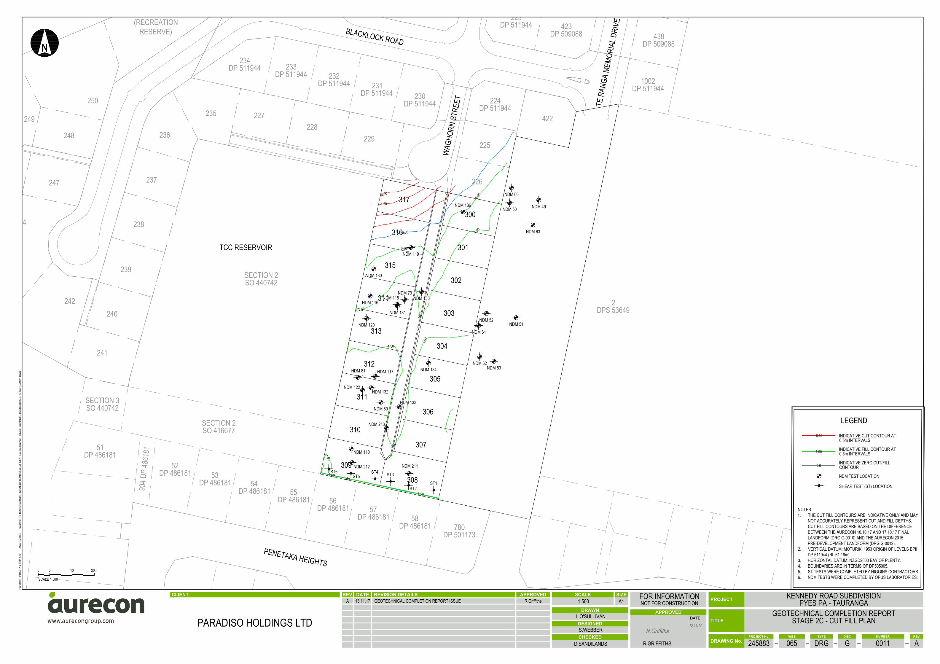
2 Site location and description The Kennedy Ridge subdivision is located on Kennedy Road, Pyes Pa, Tauranga. The site is located on an elevated ridge that originally comprised a kiwifruit orchard planted across undulating topographic landform. Moderate to steep slopes up to 45 m in height fall below the subdivision along its western and southwestern boundary. The lots covered by this report are located predominantly in the south-east corner of the subdivision immediately east of the TCC Kennedy Road Reservoir development. The eastern side of the TCC Reservoir comprises an approximately 7m high batter, with an indicative gradient of 3H:1V to 2.5H:1V. The toe of this batter lies directly adjacent to the western boundaries of Lots 310 to 317.
The landform across the subdivision development has been earthworked between 2015 and 2017 to modify the original landform for the purposes of residential building construction. Generally, the earthworks undertaken involved cuts to lower the original ridge profile to create level platforms for future building construction. Cuts of up to 6.0 m have been made elsewhere within the subdivision, however the lots within Stage 2C have undergone fill earthworks of up to approximately 1.5 m. In support of this G2 report, the following drawings are provided in Appendix B:
Project 245883-065 File 245883-065-2C-GCR-Rev1.docx 13 November 2017 Revision 1 Page 2
The pre-development landform - 245883-065-DRG-G-0010-A;
The cut to fill earthworks plan - 245883-065-DRG-G-0011-A; and
The as-built final landform plan - 245883-065-DRG-G-0012-A.
3 Proposed subdivision development The development comprises the subdivision of the original property to form residential lots with access roads and civil services infrastructure. Construction of the overall subdivision is being staged, and the area of the subdivision covered by this G2 report (Stage 2C) includes eighteen residential lots accessed from a single right of way.
Each of the dwellings proposed to be constructed within the residential lots are expected to be designed and constructed in accordance with NZS3604:2011 Timber Framed Buildings.8 All stormwater and effluent will be reticulated to council services.
4 Geotechnical considerations
4.1 Pre-development geotechnical assessment
The geotechnical requirements for development of the subdivision are outlined in the “Suitability for Subdivision” report (Aurecon, 2015a),1 and are summarised below:
4.1.1 Foundation bearing capacity
“Foundations for residential structures are anticipated to lie on either or a combination of Ash, Matua Subgroup, or engineered fill. Following completion of earthworks further inspection and testing of the foundation subgrade by a geotechnical engineer will be required within the final building platforms as part of the Geotechnical Completion Report to confirm foundation bearing capacity conditions and to provide geotechnical recommendations for building.
Based on the results of in-situ shear strength testing, the Younger Ash and Hamilton Ash beds which underlie the majority of the site generally meet the requirements for ‘good ground’ in accordance with NZS3604:2011.8 Based on our knowledge of local ground conditions, Rotoehu Ash is not considered suitable for bearing foundations due to its loose nature and tendency to be associated with groundwater flow following rainfall. It is therefore recommended that, where the proposed landform design exposes areas of Rotoehu Ash at the surface, these areas are undercut and replaced to design level with engineered fill compacted in accordance with NZS4431:1989.9
Matua Subgroup deposits are variable and comprise soils ranging from loose to medium dense sands and soft to stiff silts and clays. The evaluation of the suitability of these soils for supporting NZS3604:20118 type foundations will be assessed and reported in geotechnical completion report based on site specific testing of each lot following completion of the finished landform. Based on the preliminary results of our investigation however, the Matua Subgroup soils are expected to be variable and in some areas may not meet the requirements of NZS3604:2011.8 In such cases there may be a requirement for either ground improvement (drying, compaction, replacement) to allow conventional NZS3604:2011 foundations; or specific foundation design for those lots which are shown to not meet the requirements of NZS3604:2011.8
Engineered fill will be placed over several areas of the site. This fill will be compacted in accordance with the earthworks specification and will be supervised to ensure an appropriate level of compaction control and consistency. Following certification of the engineered filling by a TCC Category 1 Soils
Project 245883-065 File 245883-065-2C-GCR-Rev1.docx 13 November 2017 Revision 1 Page 3
Engineer, these soils are expected to meet the requirements of NZS3604:20118 and allow conventional foundations to be constructed.”
4.1.2 Earthworks
“Engineered fill shall be placed, monitored, tested and certified in accordance with the TCC Infrastructure Development Code (IDC)10 - Design Standard 10 (Natural Hazards and Earthworks). This recommends compaction in accordance with NZS4431:1989,9 under the supervision of a TCC Category 1 soils engineer. All fill compliance testing should be carried out by an IANZ-accredited laboratory as specified by the IDC.
Typical compaction requirements in cohesive ash soils are ≤10% air voids and undrained shear strength ≥150 kPa. Typical compaction requirements in sand soils are ≥95% Maximum Dry Density and ≥5 DCP blows per 100 mm. A TCC Category 1 soils engineer shall be engaged to provide specification and recommendations for testing and compaction control as part of the earthworks specification.”
4.1.3 Liquefaction
“The site is situated on an elevated ridge underlain by a thick mantle of cohesive and granular soils. Groundwater was not identified within any of the test locations, which were advanced to depths of up to 30 m below ground level. The nearest water Bay of Plenty Regional Council bores indicate that groundwater is likely to be at ~47 – 58 m bgl (7 – 11 m RL). Cohesive soils and soils above the groundwater table are not considered susceptible to liquefaction. However, although not encountered during Aurecon’s investigation, it is expected that perches water bodies will periodically form within the Rotoehu Ash following heavy rainfall events. Given the significant thickness of the non-liquefiable crust, it is not considered that the site will be susceptible to liquefaction induced settlement or lateral spread hazard.”
4.1.4 Retaining walls
“Retaining walls exceeding 1.5 m retained height will require building consent and shall be designed and certified by a Chartered Professional Engineer.
Retaining walls of any height that are deemed to be surcharged by a slope, building or driveway or any other structure requiring building consent, shall be designed and certified by a Chartered Professional Engineer.”
4.1.5 Minimum building platform levels
There are no minimum building platform levels required to mitigate flooding for the site.
4.1.6 Stormwater and effluent disposal
“It is understood that the preferred effluent disposal method for the site will be via reticulation to TCC systems. All stormwater falling on hard surfaces shall be collected and directed to council reticulation. The disposal of stormwater to ground is not recommended for this site.
4.2 Site earthworks and landform construction
The earthworks within the subject lots were completed during summer earthworks seasons between 2015 and 2017. Continued earthworks for future stages of the site development are still being undertaken further to the east as part of Stage 3. The appointed earthworks contractor for the subject lots was Waiotahi Contractors Limited.
The earthworks comprised stripping site topsoil, undercut and removal of unsuitable materials (any existing fill or weak soils), and completion of predominantly fill earthworks to re-contour the site to
Project 245883-065 File 245883-065-2C-GCR-Rev1.docx 13 November 2017 Revision 1 Page 4
achieve the design landform. Approximate cut depths of up to 2.0 m, and fills of up to 1.5 m were formed. Cuts to the soil were achieved using a combination of road scrapers, dozers and excavators.
Engineered fill was placed using earthmovers and compacted using a combination of trailer towed or self-driven sheepsfoot rollers. Lots were trimmed using smooth-bucket excavators. Site-won cohesive ash was re-used for engineered fill and no bulk fill material was imported from off-site during the duration of works. Site-won topsoil was re-spread over the finished landform.
Following completion of bulk earthworks, cantilevered timber pole retaining walls with timber laggings were constructed within Lots 308 and 309 by Landscape Developments Limited and NZ Structures Limited. The walls range in height from approximately 1.5 to 1.8 m. These retaining walls were designed and inspected by a Chartered Professional Engineer from Aurecon. Building consent was granted by TCC for the walls created as part of this stage of development. Aurecon’s inspection report and construction review producer statement for these walls will be provided separately as part of the building consent process.
The testing of road subgrades and service trench backfills was completed as part of the civil construction and reported in the Civil Asset Completion Report for this project. In summary, the following earthworks were completed:
Stripping of topsoil and unsuitable material to expose the natural subgrade. All subgrade was inspected and approved by an engineer from Aurecon prior to any filling commencing.
Bulk cutting and filling to create the current landform, with cuts of up to approximately 2.0 m depth and fill of up to 1.5 m placed near the top of slopes to modify the landform.
Engineered cantilevered timber pole retaining walls were constructed to retain Lots 308 and 309, with fill placed behind these walls to create the finished landform.
4.3 Ground conditions
The site geology is presented on the IGNS 1:250,000 scale map sheet 5 ‘Geology of the Rotorua Area’ and described in the accompanying memoir by Leonard et al. (2010).11 This regional mapping indicates that the site is underlain by the Chimp Formation, a Quaternary ignimbrite derived from the Taupo Volcanic Zone.
Site ground conditions were investigated during the original geotechnical investigation (Aurecon, 2015a),1 and were refined by Aurecon’s earthworks observations, contractor supplied compliance testing, and Aurecon’s subsequent lot by lot testing undertaken at the completion of earthworks and landform development.
The pre-development substrata originally comprised a typical ash sequence commonly encountered in Tauranga, which are (from youngest to oldest) the Younger Ash, Rotoehu Ash, and Hamilton Ash. The Younger Ash comprises very stiff silts, interspersed with pumiceous and sandy silt layers. The Rotoehu Ash generally comprises loose sand and overlies the Hamilton Ash, which typically comprises very stiff silt and clayey silt. The uppermost part of the Hamilton Ash often contains a distinctive paleosol (locally referred to as the ‘Chocolate Layer’).
This ash sequence is locally underlain by the Matua Subgroup, which includes pumiceous and rhyolitic silt, sand and gravel, estuarine mud, lignite and peat, intercalated with airfall tephras and thin distal ignimbrites (Briggs, 1996).12 Rhyolitic silts may be dominated by aluminosilicate clay minerals (e.g., halloysite), which contribute to high porosity and elevated moisture content, promoting sensitive soil behaviour (i.e. loss of shear strength upon remoulding).
Non-welded ignimbrite (Chimp Formation, also referred to as Te Ranga Ignimbrite)13, 14 is inferred to underlie the Matua Subgroup at varying depths below the site. The Chimp Formation is Pleistocene in
Project 245883-065 File 245883-065-2C-GCR-Rev1.docx 13 November 2017 Revision 1 Page 5
age, having been deposited between 0.1 - 1.0 Ma, and is a whitish grey, non-welded, crystal and pumice-poor ignimbrite containing small pinkish grey pumice and lithics of obsidian and rhyolite (Briggs, 1996).12 The Chimp Formation was typically encountered as a light grey, medium dense to dense, fine to medium grained pumiceous sand.
The final landform subgrades comprise either stiff orangish brown ash silts (i.e., Younger Ash or Hamilton Ash), stiff brown engineered fill (reworked ash silts) or some combination of these across each of the subject lots.
4.4 Earthworks compliance
4.4.1 Specification
All earthworks activities were carried out in accordance with the requirements of NZS4431:1989,9 and the Tauranga City Council Infrastructure Development Code (2017).10 The requirements for earth fill and frequency of compaction testing was undertaken in accordance with the project earthworks specification (Aurecon, 2015b),2 and is summarised as follows:
Any imported fill material shall be consistent and subject to approval from the Engineer;
The engineer must inspect and improve the stripped subgrade surface prior to fill placement; and
1 Nuclear Densometer (NDM) test per 350 m3 of fill placed, with shear vane or Scala Penetrometer Testing (SPT). Acceptance criteria defined as follows:
Cohesive soils: average undrained shear strength of 150 kPa, minimum of 140 kPa; maximum average of 8% air voids per ten tests with 10% maximum for any one test.
Non-cohesive soils – minimum of 5 blows per 100 mm with Scala Penetrometer.
4.4.2 Results
The earthworks compliance testing was commissioned by Waiotahi Contractors Limited and undertaken by Opus laboratory and is summarised in Table 1. Testing indicates that fill within all subject lots is suitable for construction as per NZS4431:1989.9 All test locations in Table 1 and Table 2 are provided on Drawing 245883-065-DRG-G-011, Appendix B, and a copy of the test reports are included in Appendix C. Based on these results, we consider that the filling has met the earthworks specification.
Table 1 Fill compliance testing results summary (undertaken by Opus Laboratory)
Test report Test No.
Results
Pass? Air voids (%)
Shear strength (kPa)
15-747
49 1.4 175 Y
50 0 UTP Y
51 3.2 UTP Y
52 0.4 160 Y
53 0.9 179 Y
15-760
60 0 UTP Y
62 0 UTP Y
63 0 UTP Y
15-849 79 2.1 161 Y
Project 245883-065 File 245883-065-2C-GCR-Rev1.docx 13 November 2017 Revision 1 Page 6
Test report Test No.
Results
Pass? Air voids (%)
Shear strength (kPa)
80 0 UTP Y
81 1.7 UTP Y
15/910
115 8.2 >161 Y
116 0 >186 Y
117 5.1 >190 Y
118 7.3 176 Y
16/009
119 2.1 UTP Y
120 6.3 >137 Y
122 0.4 >144 Y
16/065
130 3.2 UTP Y
131 4.4 UTP Y
132 6.3 UTP Y
133 4.5 167 Y
134 1.7 190 Y
135 2.5 UTP Y
136 2.1 198 Y
TG569
211 5.9 UTP Y
212 9.1 UTP Y
213 0.7 UTP Y
Following the above bulk engineered filling and testing, additional earthworks were completed by Higgins to backfill behind the retaining walls on the southern boundary of Lots 308 and 309. Six hand augered boreholes (ST1 to ST6) were undertaken approximately 2.0 m back from retaining walls constructed. This was done to assess the shear strength of the retaining wall backfill (cohesive ash). Shear vanes were taken at regular depth intervals within each borehole, the results of which are summarised in Table 2. These shear strengths are non-compliant with the earthworks specification and this has been accounted for by our foundation requirements (Section 5.4).
Table 2 Summary of hand augered borehole fill testing (undertaken by Higgins)
Shear strength
(kPa)
Test No.
1 2 3 4 5 6
Lot number
308 309
Minimum 94 129 94 105 113 91
Average 136 151 115 118 132 93
1. Test report reference: Retaining wall shears lot 308,309 (Appendix C).
Project 245883-065 File 245883-065-2C-GCR-Rev1.docx 13 November 2017 Revision 1 Page 7
5 Geotechnical requirements for building
5.1 General
Eighteen residential lots (Lots 300 to 317 inclusive) have been considered as part of this Geotechnical Completion Report. This section of the report deals with:
a) The suitability of the created lots for building complying with the requirements of NZS 3604:2011: Timber Framed Buildings;8
b) Specific requirements for residential construction on the lots; and
c) Advisory notes to owners and lot developers.
The specific requirements should be read in conjunction with the general recommendations for building and the advisory notes contained in this section of the report.
5.2 Lot by lot investigations
The ground conditions within each lot has been individually investigated by two hand augered boreholes typically drilled to depths ranging between 1.0 m and 2.0 m bgl (respectively), for the purpose of verifying earthworks and shallow foundation conditions. Shear vane testing was undertaken at regular depth intervals (every 300 mm) within cohesive soils. Test locations are presented on Drawing 245883-065-DRG-G-0012-A, Appendix B, and hand auger borehole logs are presented in Appendix D.
5.3 Suitability of lots for building
The subject lots are considered suitable on which to construct residential dwellings that comply with the characteristics defined by NZS3604:2011: Timber Framed Buildings.8 We consider that the information provided within this report is sufficient to support building consent for dwellings developed at the site, provided that the existing building platform landforms are not notably modified (i.e. cut and/or filled by more than 300 mm total depth).
There are specific requirements that relate to the lots as given in Section 5.4, and as summarised in the lot summary sheets included in Appendix A. The suitability of lots for building is contingent on the specific requirements for building being included into the planning, design and construction of new dwellings and any other structure requiring a building consent under the Building Act 2004.15
5.4 Specific requirements for building
5.4.1 Bearing capacity (Lots 300 to 307 inclusive; Lots 310 to 317 inclusive)
Our lot by lot testing indicates that the founding subgrade for these lots comprises stiff to very stiff in- cohesive ash or sandy ash (typical Tauranga sequence) or some combination of these, generally overlain by topsoil. These materials are natural in-situ materials, or placed as engineered fill. The foundation subgrade is considered to meet the requirements of good ground, as defined within NZS3604:2011.8
An ultimate bearing capacity of 300 kPa may be adopted for design of shallow foundations on these lots, designed in accordance with NZS3604:2011.8 This bearing capacity should be multiplied by the reduction factors below:
Project 245883-065 File 245883-065-2C-GCR-Rev1.docx 13 November 2017 Revision 1 Page 8
ULS: 0.5;
SLS: 0.33; and
Earthquake loading: 0.7.
5.4.2 Bearing capacity (Lots 308 and 309)
Our lot by lot testing indicates that the founding subgrade for these lots comprises stiff to very stiff cohesive ash or sandy ash (typical Tauranga sequence) or some combination of these, generally overlain by topsoil. However, some fill material placed behind the retaining wall on the southern boundary of these lots did not meet the requirements of the earthworks specification or NZS4431.9 Shear vane testing of this fill material indicates shear strengths of between ~90 and ~130 kPa. Due to the lower strength of fill within this area an ultimate bearing capacity of 150 kPa shall be adopted for design of shallow foundations on these lots, designed in accordance with NZS3604:2011.8 This bearing capacity should be multiplied by the reduction factors below:
ULS: 0.5;
SLS: 0.33; and
Earthquake loading: 0.7.
5.4.3 Settlement (all lots)
Buildings will need to be flexible to withstand up to 25 mm of differential settlement over a 6 m length, as indicated by Appendix B Section B1 of the NZ Building Code Handbook and Approved Documents.16 Provided that the foundation subgrades are suitably prepared (e.g. free of loose or softened soils and water) prior to pouring concrete, settlements are estimated to be less than 25 mm under the loads imposed by a dwelling constructed in accordance with NZS3604:2011.8
5.4.4 Foundation requirements and inspections (all lots)
Prior to foundation construction, the contractor should ensure that the subgrade surface is well compacted by rolling with a non-vibrating smooth drum roller. All foundation subgrades should be free of any loosened surficial soils and ponded water prior to concrete pour. All topsoil shall be removed from beneath building foundations and floor slabs prior to building. Any subgrade that has been loosened should be re-compacted or removed and replaced with either site concrete or granular fill compacted in accordance with NZS4431:1989.9
The foundation subgrade is to be inspected by a suitably qualified and/or experienced professional prior to pouring concrete or placement of any levelling fill (e.g. fill fines to level subgrade prior to rib-raft construction). Foundations may need to be deepened or broadened or both should unsuitable subgrade be encountered during excavation. If rectification is required due to unsuitable subgrade, a 300 mm undercut and replacement with compacted sand or a 200 mm undercut and replacement with compacted hard fill may be an appropriate solution.
5.4.5 Building Restriction Lines - Lots 308 and 309
Confirmed Building Restriction Lines (BRLs) are shown on Drawing 245883-065-DRG-G-0012, Appendix B. Lots 308 and 309 have BRLs behind the retaining walls located on their southern boundaries due to non-compliant wall backfill (see Section 4.4.2. Table 2). The areas contained by the site boundaries and the BRLs are defined as ‘building exclusion zones’. These zones have been confirmed to ensure sufficient set back of the building from the wall to mitigate inadvertent building surcharge of the retaining walls for which a surcharge has not been assumed in design.
Project 245883-065 File 245883-065-2C-GCR-Rev1.docx 13 November 2017 Revision 1 Page 9
Any structure requiring a building consent as defined by the Building Act 2004,15 any landscaping fills, retaining structures of any proportion and excavation to alter the topography are not to extend over the BRL into the ‘building exclusion zone’ without specific investigation, assessment and design by a Tauranga City Council Category 1 Geo-professional.
5.5 Retaining walls
Engineer designed timber pole retaining walls with timber laggings have been constructed as part of the subdivision development along the southern boundaries of Lots 308 and 309. Timber pole walls approximately 0.8 to 1.3 m high are also proposed to retain the eastern boundaries of Lots 300 to 308, which have not yet been constructed. The construction review reports and producer statements these retaining walls will be provided separately as part of the building consent process.
As specified in clause F4.3.1 of the Building Code, a barrier is required to be constructed to safeguard people from falling, where the height of the retaining wall exceeds 1.0 m and the area is associated with the use of a building. Permanent barriers shall be the responsibility of the future lot owners where applicable. Examples of areas associated with the use of a building in respect to retaining walls:
On the edge of driveways;
Near pedestrian access routes to and from buildings; and
Amenity areas used in conjunction with the use of a dwelling.
5.6 Stormwater and effluent disposal
All stormwater run-off and effluent shall be collected and reticulated to council systems located on Kennedy Road. The onsite disposal of stormwater or effluent is not permitted.
5.7 Advisory notes
5.7.1 Topsoil thickness
The presence of topsoil within completed lots is generally 0 to 200 mm thick, though may be of variable thickness locally. Topsoil was not observed at some locations based on the lot by lot hand augered borehole logs. To assess the thickness of topsoil identified during testing please refer to the hand auger borehole logs given in Appendix D, which include the relevant lot number. No guarantee is given or implied for the topsoil depth on any lot created within this subdivision.
5.7.2 Natural soil stratigraphy
Excavations for foundations may intersect weak soil layers. The quality, strength and density of the ground conditions varies across the site and where weak soil is encountered in excavations, foundation deepening, broadening or both may be necessary.
5.7.3 Shallow fill thickness
Within some of the lots, thin engineered fill may be present; excavations for building development may intersect the natural ground beneath this filling.

Project 245883-065 File 245883-065-2C-GCR-Rev1.docx 13 November 2017 Revision 1 Page 10
6 Natural hazards assessment A summary of natural hazards for the completed landform is presented in Table 3.
Table 3 Natural hazard table
Natural hazard Applicable to site
Mitigation (if required)
Flooding N All building platforms have been constructed above flood levels.
Specific design for stormwater disposal
Y Site stormwater will be managed through the site stormwater reticulation system.
Stormwater sensitive
N Overland flow will be managed through site stormwater reticulation system. In-ground soakage is not permitted for this site. All surface run off and overland flow should be diverted away from areas of sloping ground for this site. Overland flows Y
Slope instability N
Liquefaction N Soils above the groundwater table are not considered susceptible to liquefaction. Therefore, the site is not considered susceptible to liquefaction or lateral spread due to the significant depth to groundwater (>30 m).
Seismic shaking Y The effect to residential NZS36048 type buildings from seismic shaking can be influenced by sound construction methods and materials composition (lightweight and ductile roofing and cladding). Shaking hazards are enhanced by the use of construction products such as masonry cladding and concrete/tile roofing.
7 S72 statement Each designated safe building platform (i.e., that area of each lot outside of the building exclusion zone set by the building restriction lines) is considered suitable for building development without the need to issue building consents pursuant to S72 of the Building Act.15
8 Limitations All assessments made in this report are based on the ground conditions indicated from published sources, site inspection and hand auger boreholes. Variations in ground conditions may occur between the investigation locations. In addition, there may be special conditions pertaining to the site which have not been revealed by the investigation and which have not therefore been considered in the report. No warranty (either expressed or implied) that the actual conditions will conform exactly to the assessments contained in this report, is included.
This report does not remove the responsibility of the owner / builder / building certifier to satisfy themselves of foundation depth and suitability at the finalised dwelling locations and to ensure foundation conditions are not allowed to deteriorate due to saturation or other causes.
Where data supplied by the developer or other external sources, including previous site inspection data, has been used, it has been assumed that the information is correct unless otherwise stated. No responsibility can be accepted by Aurecon NZ Limited for inaccuracies within the data supplied by others.
Any comments on groundwater conditions are based on observations made at the time of investigation unless otherwise stated. It should be noted that groundwater levels vary due to seasonal or other effects.
Project 245883-065 File 245883-065-2C-GCR-Rev1.docx 13 November 2017 Revision 1 Page 11
This report is provided for sole use by the client. It shall not be used, reproduced or interpreted for any purpose other than is specifically set out in the text of this report.
9 References 1. Aurecon, 245883-003-01 - Kennedy Road Development Geotechnical suitability for subdivision
(G1) report. 2015a: Paradiso Holdings Ltd. 2. Aurecon, Kennedy Road Development Sierra Heights Stage 1A1 Geotechnical Completion
Report: Lots 1-6 and 35 to 50 (inclusive). 2015b: Paradiso Holdings Ltd. 3. Aurecon, Sierra Heights Stage 1A2 Residential Subdivision (Lots 7 to 34 inclusive) Geotechnical
Completion Report. 2016a: Paradiso Holdings Ltd. 4. Aurecon, Kennedy Ridge Residential Subdivision Stage 1B & 2A (Lots 100-102, 105, 107-116,
119-145, 208-217, 219, 220) Geotechnical Completion Report. 2017a: Paradiso Holdings Limited.
5. Aurecon, Kennedy Ridge Residential Subdivision Stage 2A (Lots 117, 118, 200-207, 221-224, 230-234, 252-254) Geotechnical Completion Report. 2017b: Paradiso Holdings Limited.
6. Aurecon, Kennedy Ridge Residential Subdivision Stage 2B (Lots 225-229, Lots 235-242, Lot 244, Lots 246-250, and Lot 422). 2017f: Paradiso Holdings Limited.
7. Aurecon, Kennedy Ridge Residential Subdivision Stage 3A (Lots 400-408, 411-413, 423-427, 429-438) G2 Geotechnical Completion Report. 2017c: Paradiso Holdings Limited.
8. Standards New Zealand, NZS 3604:2011 - New Zealand Standard, Timber-framed buildings. 2011. p. 447.
9. Standards New Zealand, NZS 4431:1989 - Code of practice for earth fill for residential development. 1989.
10. Tauranga City Council, Tauranga City Council Infrastructure Development Code. 2017. 11. Leonard et al., Geology of the Rotorua Area. 2011. 12. Briggs, R., et al., Geology of the Tauranga area, Sheet U14 1:50,000. Department of Earth
Sciences Occasional Report, 1996(22). 13. White, P., et al., Groundwater resource investigations of the Western Bay of Plenty area stage
1–conceptual geological and hydrological models and preliminary allocation assessment. GNS Science consultancy report, 2008. 240: p. 221.
14. Karhunen, R.A., The Pokai and Chimp Ignimbrites of NW Taupo Volcanic Zone. 1993. 15. Building Act. 2004. 16. Ministry of Business Innovation and Employment, Acceptable Solutions and Verification
Methods for NZ Building Code, Appendix B, Section B1, Structure 2014.

Appendices


Appendix AGeotechnical suitability
statement and lot summarysheets
Appendix A Geotechnical suitability statement and lot summary sheets

Aurecon New Zealand Limited Ground Level 247 Cameron Road Tauranga 3110
PO Box 2292 Tauranga 3140 New Zealand
T F E W
+64 7 578 6183 +64 7 578 6143 [email protected] aurecongroup.com
Project 245883 File G2 Statement.docx 13 November 2017 Revision 0 Page 1
Statement of professional opinion as to the geotechnical suitability of the land for building
Development: Kennedy Ridge Subdivision Stage 2C – Lots 300 to 317 Engineer responsible for investigation: Richard Griffiths Qualifications: TCC Category 1 Geo Professional I, Richard Griffiths, an employee of Aurecon NZ Limited: Hereby confirm that I am an accredited Category 1 Geo Professional appropriately qualified with experience in geotechnical engineering to ascertain the suitability of the land for building development and was retained as the soils engineer to the above development.
1. An appropriate level of site investigation and construction supervision has been carried out
under my direction and as described in our Geotechnical Completion Report reference 245883-065-2C-GCR dated 13 November 2017.
2. In my professional opinion, not to be construed as a guarantee of certainty or completeness, I
consider that;
a. All residential subject lots within this development are suitable on which to erect dwellings that comply with NZS 3604:2011 Timber Framed Buildings.
b. All of the subject lots are suitable for building development with respect to natural
hazards without the need to issue building consent pursuant to Section 72 of the Building Act.
This opinion is given on the condition that:
c. The content of the Geotechnical Completion Report reference 245883-065-2C-GCR dated 13 November 2017 is made available to each lot owner and that the specific requirements for building development set out in this report as they apply to each lot are followed.
3. This professional opinion is furnished to Tauranga City Council and Paradiso Holdings
Limited, the developer, for their purpose alone, on the express condition that it will not be relied upon by any other person and does not relieve lot owners, their advisers, or the Territorial Authority from their respective responsibilities and does not remove the necessity for normal inspection of foundation conditions at the time of erection for any dwelling.
Signed: for and on behalf of Aurecon NZ Limited
Richard Griffiths Date Tauranga City Council Category 1 Geo Professional 13 November 2017
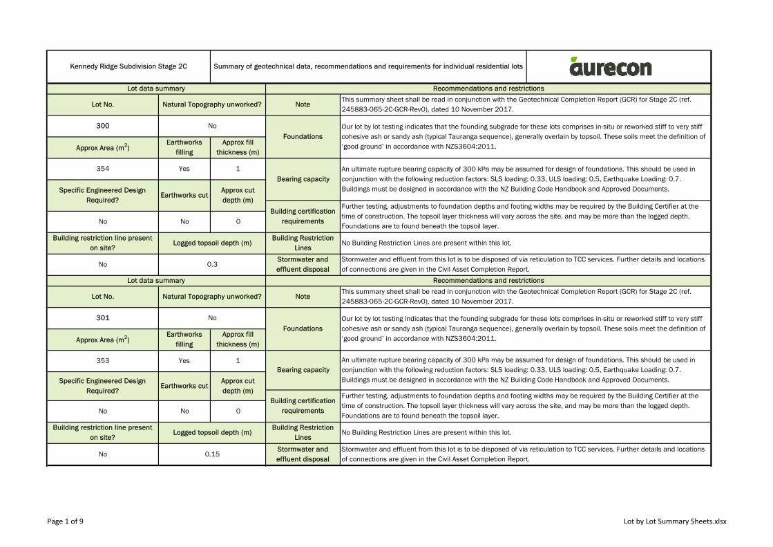
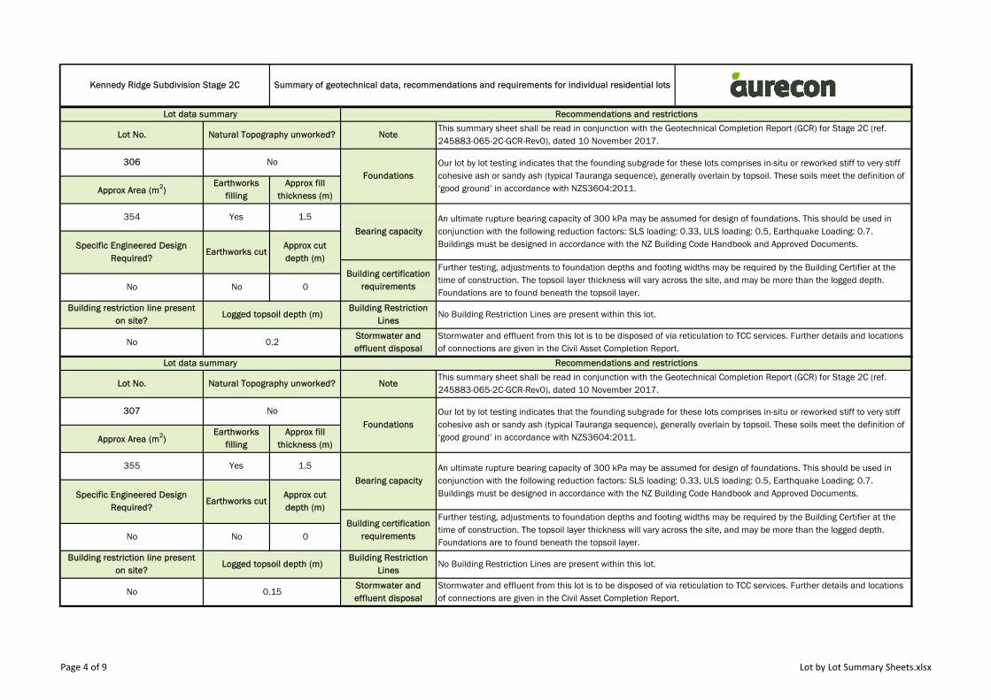
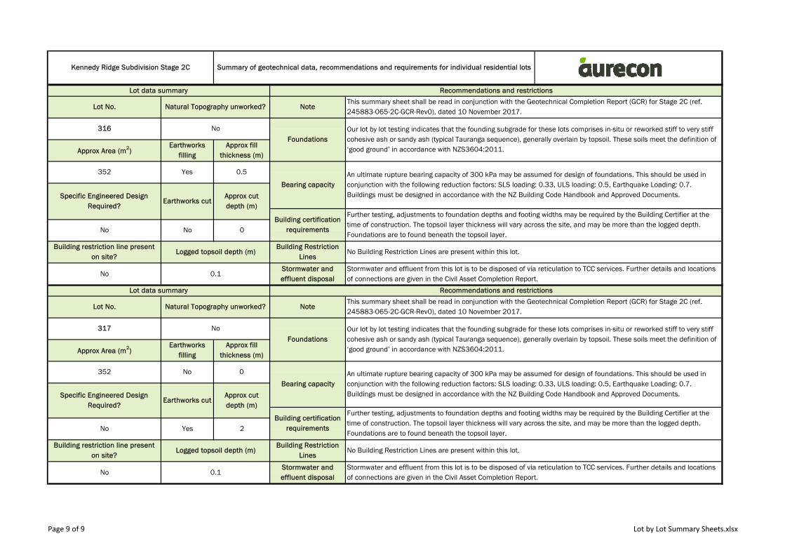
Lot data summary
0
Logged topsoil depth (m)
0.3
Recommendations and restrictions
Building Restriction Lines
Stormwater and effluent disposal
No
Earthworks filling
Earthworks cut
Approx fill thickness (m)
1
Approx cut depth (m)
Foundations
Building restriction line present on site?
No
Yes
No
354
300
Approx Area (m2)
Specific Engineered Design Required?
No
Kennedy Ridge Subdivision Stage 2C Summary of geotechnical data, recommendations and requirements for individual residential lots
Our lot by lot testing indicates that the founding subgrade for these lots comprises in-situ or reworked stiff to very stiff cohesive ash or sandy ash (typical Tauranga sequence), generally overlain by topsoil. These soils meet the definition of ‘good ground’ in accordance with NZS3604:2011. Approx Area (m2)
Earthworks filling
Approx fill thickness (m)
Our lot by lot testing indicates that the founding subgrade for these lots comprises in-situ or reworked stiff to very stiff cohesive ash or sandy ash (typical Tauranga sequence), generally overlain by topsoil. These soils meet the definition of ‘good ground’ in accordance with NZS3604:2011.
Lot data summary Recommendations and restrictions
Lot No. Natural Topography unworked?
No Building Restriction Lines are present within this lot.
Stormwater and effluent from this lot is to be disposed of via reticulation to TCC services. Further details and locations of connections are given in the Civil Asset Completion Report.
Building certification requirements
Further testing, adjustments to foundation depths and footing widths may be required by the Building Certifier at the time of construction. The topsoil layer thickness will vary across the site, and may be more than the logged depth. Foundations are to found beneath the topsoil layer.
Bearing capacityAn ultimate rupture bearing capacity of 300 kPa may be assumed for design of foundations. This should be used in conjunction with the following reduction factors: SLS loading: 0.33, ULS loading: 0.5, Earthquake Loading: 0.7. Buildings must be designed in accordance with the NZ Building Code Handbook and Approved Documents.
Lot No. Natural Topography unworked?
No Building Restriction Lines are present within this lot.
No 0.15Stormwater and effluent disposal
Stormwater and effluent from this lot is to be disposed of via reticulation to TCC services. Further details and locations of connections are given in the Civil Asset Completion Report.
This summary sheet shall be read in conjunction with the Geotechnical Completion Report (GCR) for Stage 2C (ref. 245883-065-2C-GCR-Rev0), dated 10 November 2017.
Note
NoteThis summary sheet shall be read in conjunction with the Geotechnical Completion Report (GCR) for Stage 2C (ref. 245883-065-2C-GCR-Rev0), dated 10 November 2017.
No No 0
Building restriction line present on site?
Logged topsoil depth (m)Building Restriction
Lines
353 Yes 1Bearing capacity
An ultimate rupture bearing capacity of 300 kPa may be assumed for design of foundations. This should be used in conjunction with the following reduction factors: SLS loading: 0.33, ULS loading: 0.5, Earthquake Loading: 0.7. Buildings must be designed in accordance with the NZ Building Code Handbook and Approved Documents.Specific Engineered Design
Required?Earthworks cut
Approx cut depth (m)
Building certification requirements
Further testing, adjustments to foundation depths and footing widths may be required by the Building Certifier at the time of construction. The topsoil layer thickness will vary across the site, and may be more than the logged depth. Foundations are to found beneath the topsoil layer.
301 No
Foundations
Page 1 of 9 Lot by Lot Summary Sheets.xlsx
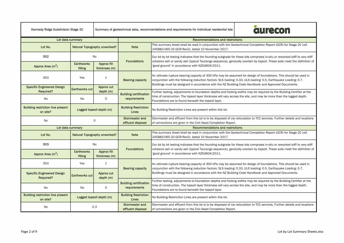
Kennedy Ridge Subdivision Stage 2C Summary of geotechnical data, recommendations and requirements for individual residential lots
Lot data summary Recommendations and restrictions
Lot No. Natural Topography unworked?
1Bearing capacity
An ultimate rupture bearing capacity of 300 kPa may be assumed for design of foundations. This should be used in conjunction with the following reduction factors: SLS loading: 0.33, ULS loading: 0.5, Earthquake Loading: 0.7. Buildings must be designed in accordance with the NZ Building Code Handbook and Approved Documents.
Specific Engineered Design Required?
Earthworks cutApprox cut depth (m)
Building certification requirements
Further testing, adjustments to foundation depths and footing widths may be required by the Building Certifier at the time of construction. The topsoil layer thickness will vary across the site, and may be more than the logged depth. Foundations are to found beneath the topsoil layer.
No No
NoteThis summary sheet shall be read in conjunction with the Geotechnical Completion Report (GCR) for Stage 2C (ref. 245883-065-2C-GCR-Rev0), dated 10 November 2017.
302
FoundationsOur lot by lot testing indicates that the founding subgrade for these lots comprises in-situ or reworked stiff to very stiff cohesive ash or sandy ash (typical Tauranga sequence), generally overlain by topsoil. These soils meet the definition of ‘good ground’ in accordance with NZS3604:2011. Approx Area (m2)
Earthworks filling
Approx fill thickness (m)
353 Yes
No
303 No
FoundationsOur lot by lot testing indicates that the founding subgrade for these lots comprises in-situ or reworked stiff to very stiff cohesive ash or sandy ash (typical Tauranga sequence), generally overlain by topsoil. These soils meet the definition of ‘good ground’ in accordance with NZS3604:2011. Approx Area (m2)
Earthworks filling
Approx fill thickness (m)
Lot data summary Recommendations and restrictions
Lot No. Natural Topography unworked? NoteThis summary sheet shall be read in conjunction with the Geotechnical Completion Report (GCR) for Stage 2C (ref. 245883-065-2C-GCR-Rev0), dated 10 November 2017.
0
Building restriction line present on site?
Logged topsoil depth (m)Building Restriction
LinesNo Building Restriction Lines are present within this lot.
No 0Stormwater and effluent disposal
Stormwater and effluent from this lot is to be disposed of via reticulation to TCC services. Further details and locations of connections are given in the Civil Asset Completion Report.
No Building Restriction Lines are present within this lot.
No 0.3Stormwater and effluent disposal
Stormwater and effluent from this lot is to be disposed of via reticulation to TCC services. Further details and locations of connections are given in the Civil Asset Completion Report.
No No 0
Building restriction line present on site?
Logged topsoil depth (m)Building Restriction
Lines
353 Yes 1
Bearing capacityAn ultimate rupture bearing capacity of 300 kPa may be assumed for design of foundations. This should be used in conjunction with the following reduction factors: SLS loading: 0.33, ULS loading: 0.5, Earthquake Loading: 0.7. Buildings must be designed in accordance with the NZ Building Code Handbook and Approved Documents.Specific Engineered Design
Required?Earthworks cut
Approx cut depth (m)
Building certification requirements
Further testing, adjustments to foundation depths and footing widths may be required by the Building Certifier at the time of construction. The topsoil layer thickness will vary across the site, and may be more than the logged depth. Foundations are to found beneath the topsoil layer.
Page 2 of 9 Lot by Lot Summary Sheets.xlsx
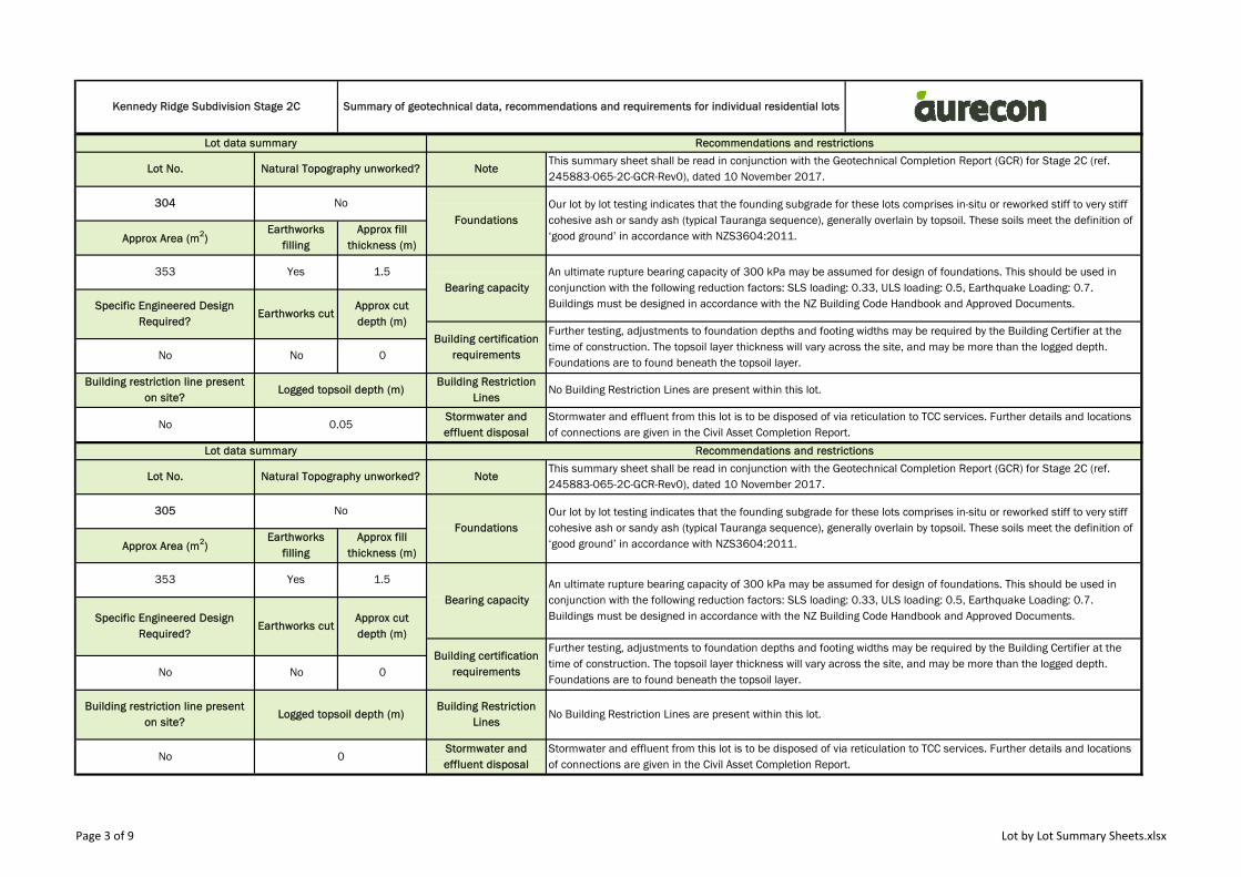
Kennedy Ridge Subdivision Stage 2C Summary of geotechnical data, recommendations and requirements for individual residential lots
Lot data summary Recommendations and restrictions
Approx fill thickness (m)
353 Yes 1.5Bearing capacity
An ultimate rupture bearing capacity of 300 kPa may be assumed for design of foundations. This should be used in conjunction with the following reduction factors: SLS loading: 0.33, ULS loading: 0.5, Earthquake Loading: 0.7. Buildings must be designed in accordance with the NZ Building Code Handbook and Approved Documents.Specific Engineered Design
Required?Earthworks cut
Approx cut depth (m)
Building certification requirements
Lot No. Natural Topography unworked? NoteThis summary sheet shall be read in conjunction with the Geotechnical Completion Report (GCR) for Stage 2C (ref. 245883-065-2C-GCR-Rev0), dated 10 November 2017.
304 No
FoundationsOur lot by lot testing indicates that the founding subgrade for these lots comprises in-situ or reworked stiff to very stiff cohesive ash or sandy ash (typical Tauranga sequence), generally overlain by topsoil. These soils meet the definition of ‘good ground’ in accordance with NZS3604:2011. Approx Area (m2)
Earthworks filling
Lot No. Natural Topography unworked? NoteThis summary sheet shall be read in conjunction with the Geotechnical Completion Report (GCR) for Stage 2C (ref. 245883-065-2C-GCR-Rev0), dated 10 November 2017.
305 No
FoundationsOur lot by lot testing indicates that the founding subgrade for these lots comprises in-situ or reworked stiff to very stiff cohesive ash or sandy ash (typical Tauranga sequence), generally overlain by topsoil. These soils meet the definition of ‘good ground’ in accordance with NZS3604:2011. Approx Area (m2)
Earthworks filling
No 0.05Stormwater and effluent disposal
Stormwater and effluent from this lot is to be disposed of via reticulation to TCC services. Further details and locations of connections are given in the Civil Asset Completion Report.
Lot data summary Recommendations and restrictions
Further testing, adjustments to foundation depths and footing widths may be required by the Building Certifier at the time of construction. The topsoil layer thickness will vary across the site, and may be more than the logged depth. Foundations are to found beneath the topsoil layer.
No No 0
Building restriction line present on site?
Logged topsoil depth (m)Building Restriction
LinesNo Building Restriction Lines are present within this lot.
No 0Stormwater and effluent disposal
Stormwater and effluent from this lot is to be disposed of via reticulation to TCC services. Further details and locations of connections are given in the Civil Asset Completion Report.
Further testing, adjustments to foundation depths and footing widths may be required by the Building Certifier at the time of construction. The topsoil layer thickness will vary across the site, and may be more than the logged depth. Foundations are to found beneath the topsoil layer.
No No 0
Building restriction line present on site?
Logged topsoil depth (m)Building Restriction
LinesNo Building Restriction Lines are present within this lot.
Approx fill thickness (m)
353 Yes 1.5
Bearing capacityAn ultimate rupture bearing capacity of 300 kPa may be assumed for design of foundations. This should be used in conjunction with the following reduction factors: SLS loading: 0.33, ULS loading: 0.5, Earthquake Loading: 0.7. Buildings must be designed in accordance with the NZ Building Code Handbook and Approved Documents.Specific Engineered Design
Required?Earthworks cut
Approx cut depth (m)
Building certification requirements
Page 3 of 9 Lot by Lot Summary Sheets.xlsx
Kennedy Ridge Subdivision Stage 2C Summary of geotechnical data, recommendations and requirements for individual residential lots
Lot data summary Recommendations and restrictions
Approx fill thickness (m)
354 Yes 1.5
Bearing capacityAn ultimate rupture bearing capacity of 300 kPa may be assumed for design of foundations. This should be used in conjunction with the following reduction factors: SLS loading: 0.33, ULS loading: 0.5, Earthquake Loading: 0.7. Buildings must be designed in accordance with the NZ Building Code Handbook and Approved Documents.Specific Engineered Design
Required?Earthworks cut
Approx cut depth (m)
Building certification requirements
Lot No. Natural Topography unworked? NoteThis summary sheet shall be read in conjunction with the Geotechnical Completion Report (GCR) for Stage 2C (ref. 245883-065-2C-GCR-Rev0), dated 10 November 2017.
306 No
FoundationsOur lot by lot testing indicates that the founding subgrade for these lots comprises in-situ or reworked stiff to very stiff cohesive ash or sandy ash (typical Tauranga sequence), generally overlain by topsoil. These soils meet the definition of ‘good ground’ in accordance with NZS3604:2011. Approx Area (m2)
Earthworks filling
Lot No. Natural Topography unworked? NoteThis summary sheet shall be read in conjunction with the Geotechnical Completion Report (GCR) for Stage 2C (ref. 245883-065-2C-GCR-Rev0), dated 10 November 2017.
307 No
FoundationsOur lot by lot testing indicates that the founding subgrade for these lots comprises in-situ or reworked stiff to very stiff cohesive ash or sandy ash (typical Tauranga sequence), generally overlain by topsoil. These soils meet the definition of ‘good ground’ in accordance with NZS3604:2011. Approx Area (m2)
Earthworks filling
No 0.2Stormwater and effluent disposal
Stormwater and effluent from this lot is to be disposed of via reticulation to TCC services. Further details and locations of connections are given in the Civil Asset Completion Report.
Lot data summary Recommendations and restrictions
Further testing, adjustments to foundation depths and footing widths may be required by the Building Certifier at the time of construction. The topsoil layer thickness will vary across the site, and may be more than the logged depth. Foundations are to found beneath the topsoil layer.
No No 0
Building restriction line present on site?
Logged topsoil depth (m)Building Restriction
LinesNo Building Restriction Lines are present within this lot.
No 0.15Stormwater and effluent disposal
Stormwater and effluent from this lot is to be disposed of via reticulation to TCC services. Further details and locations of connections are given in the Civil Asset Completion Report.
Further testing, adjustments to foundation depths and footing widths may be required by the Building Certifier at the time of construction. The topsoil layer thickness will vary across the site, and may be more than the logged depth. Foundations are to found beneath the topsoil layer.
No No 0
Building restriction line present on site?
Logged topsoil depth (m)Building Restriction
LinesNo Building Restriction Lines are present within this lot.
Approx fill thickness (m)
355 Yes 1.5
Bearing capacityAn ultimate rupture bearing capacity of 300 kPa may be assumed for design of foundations. This should be used in conjunction with the following reduction factors: SLS loading: 0.33, ULS loading: 0.5, Earthquake Loading: 0.7. Buildings must be designed in accordance with the NZ Building Code Handbook and Approved Documents.Specific Engineered Design
Required?Earthworks cut
Approx cut depth (m)
Building certification requirements
Page 4 of 9 Lot by Lot Summary Sheets.xlsx
Kennedy Ridge Subdivision Stage 2C Summary of geotechnical data, recommendations and requirements for individual residential lots
Lot data summary Recommendations and restrictions
Approx fill thickness (m)
450 Yes 1.5Bearing capacity
An ultimate rupture bearing capacity of 150 kPa may be assumed for design of foundations. This should be used in conjunction with the following reduction factors: SLS loading: 0.33, ULS loading: 0.5, Earthquake Loading: 0.7. Buildings must be designed in accordance with the NZ Building Code Handbook and Approved Documents.Specific Engineered Design
Required?Earthworks cut
Approx cut depth (m)
Building certification requirements
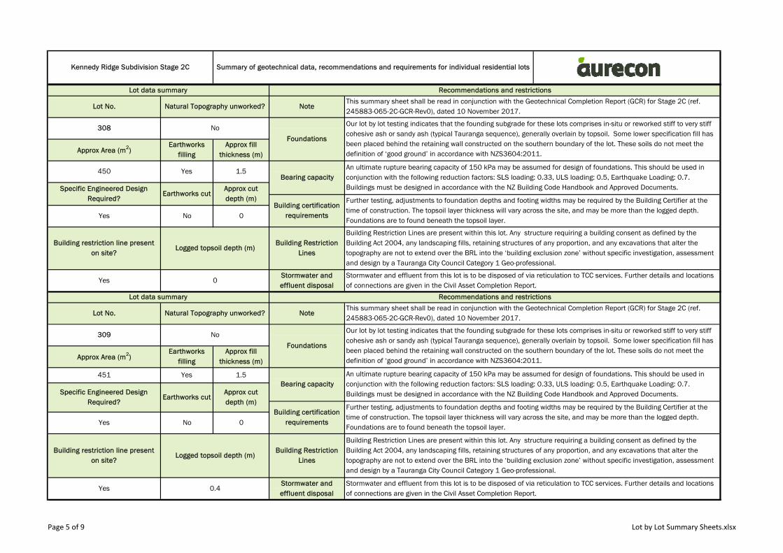
Lot No. Natural Topography unworked? NoteThis summary sheet shall be read in conjunction with the Geotechnical Completion Report (GCR) for Stage 2C (ref. 245883-065-2C-GCR-Rev0), dated 10 November 2017.
308 No
Foundations
Our lot by lot testing indicates that the founding subgrade for these lots comprises in-situ or reworked stiff to very stiff cohesive ash or sandy ash (typical Tauranga sequence), generally overlain by topsoil. Some lower specification fill has been placed behind the retaining wall constructed on the southern boundary of the lot. These soils do not meet the definition of ‘good ground’ in accordance with NZS3604:2011. Approx Area (m2)
Earthworks filling
Lot No. Natural Topography unworked? NoteThis summary sheet shall be read in conjunction with the Geotechnical Completion Report (GCR) for Stage 2C (ref. 245883-065-2C-GCR-Rev0), dated 10 November 2017.
309 No
Foundations
Our lot by lot testing indicates that the founding subgrade for these lots comprises in-situ or reworked stiff to very stiff cohesive ash or sandy ash (typical Tauranga sequence), generally overlain by topsoil. Some lower specification fill has been placed behind the retaining wall constructed on the southern boundary of the lot. These soils do not meet the definition of ‘good ground’ in accordance with NZS3604:2011. Approx Area (m2)
Earthworks filling
Yes 0Stormwater and effluent disposal
Stormwater and effluent from this lot is to be disposed of via reticulation to TCC services. Further details and locations of connections are given in the Civil Asset Completion Report.
Lot data summary Recommendations and restrictions
Further testing, adjustments to foundation depths and footing widths may be required by the Building Certifier at the time of construction. The topsoil layer thickness will vary across the site, and may be more than the logged depth. Foundations are to found beneath the topsoil layer.
Yes No 0
Building restriction line present on site?
Logged topsoil depth (m)Building Restriction
Lines
Building Restriction Lines are present within this lot. Any structure requiring a building consent as defined by the Building Act 2004, any landscaping fills, retaining structures of any proportion, and any excavations that alter the topography are not to extend over the BRL into the ‘building exclusion zone’ without specific investigation, assessment and design by a Tauranga City Council Category 1 Geo-professional.
Yes 0.4Stormwater and effluent disposal
Stormwater and effluent from this lot is to be disposed of via reticulation to TCC services. Further details and locations of connections are given in the Civil Asset Completion Report.
Further testing, adjustments to foundation depths and footing widths may be required by the Building Certifier at the time of construction. The topsoil layer thickness will vary across the site, and may be more than the logged depth. Foundations are to found beneath the topsoil layer.
Yes No 0
Building restriction line present on site?
Logged topsoil depth (m)Building Restriction
Lines
Building Restriction Lines are present within this lot. Any structure requiring a building consent as defined by the Building Act 2004, any landscaping fills, retaining structures of any proportion, and any excavations that alter the topography are not to extend over the BRL into the ‘building exclusion zone’ without specific investigation, assessment and design by a Tauranga City Council Category 1 Geo-professional.
Approx fill thickness (m)
451 Yes 1.5Bearing capacity
An ultimate rupture bearing capacity of 150 kPa may be assumed for design of foundations. This should be used in conjunction with the following reduction factors: SLS loading: 0.33, ULS loading: 0.5, Earthquake Loading: 0.7. Buildings must be designed in accordance with the NZ Building Code Handbook and Approved Documents.Specific Engineered Design
Required?Earthworks cut
Approx cut depth (m)
Building certification requirements
Page 5 of 9 Lot by Lot Summary Sheets.xlsx
Kennedy Ridge Subdivision Stage 2C Summary of geotechnical data, recommendations and requirements for individual residential lots
Lot data summary Recommendations and restrictions
Approx fill thickness (m)
357 Yes 1.5
Bearing capacityAn ultimate rupture bearing capacity of 300 kPa may be assumed for design of foundations. This should be used in conjunction with the following reduction factors: SLS loading: 0.33, ULS loading: 0.5, Earthquake Loading: 0.7. Buildings must be designed in accordance with the NZ Building Code Handbook and Approved Documents.Specific Engineered Design
Required?Earthworks cut
Approx cut depth (m)
Building certification requirements
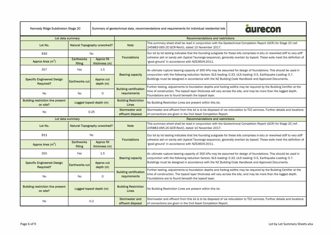
Lot No. Natural Topography unworked? NoteThis summary sheet shall be read in conjunction with the Geotechnical Completion Report (GCR) for Stage 2C (ref. 245883-065-2C-GCR-Rev0), dated 10 November 2017.
310 NoFoundations
Our lot by lot testing indicates that the founding subgrade for these lots comprises in-situ or reworked stiff to very stiff cohesive ash or sandy ash (typical Tauranga sequence), generally overlain by topsoil. These soils meet the definition of ‘good ground’ in accordance with NZS3604:2011. Approx Area (m2)
Earthworks filling
Lot No. Natural Topography unworked? NoteThis summary sheet shall be read in conjunction with the Geotechnical Completion Report (GCR) for Stage 2C (ref. 245883-065-2C-GCR-Rev0), dated 10 November 2017.
311 No
FoundationsOur lot by lot testing indicates that the founding subgrade for these lots comprises in-situ or reworked stiff to very stiff cohesive ash or sandy ash (typical Tauranga sequence), generally overlain by topsoil. These soils meet the definition of ‘good ground’ in accordance with NZS3604:2011. Approx Area (m2)
Earthworks filling
No 0.25Stormwater and effluent disposal
Stormwater and effluent from this lot is to be disposed of via reticulation to TCC services. Further details and locations of connections are given in the Civil Asset Completion Report.
Lot data summary Recommendations and restrictions
Further testing, adjustments to foundation depths and footing widths may be required by the Building Certifier at the time of construction. The topsoil layer thickness will vary across the site, and may be more than the logged depth. Foundations are to found beneath the topsoil layer.
No No 0
Building restriction line present on site?
Logged topsoil depth (m)Building Restriction
LinesNo Building Restriction Lines are present within this lot.
No 0.2Stormwater and effluent disposal
Stormwater and effluent from this lot is to be disposed of via reticulation to TCC services. Further details and locations of connections are given in the Civil Asset Completion Report.
Further testing, adjustments to foundation depths and footing widths may be required by the Building Certifier at the time of construction. The topsoil layer thickness will vary across the site, and may be more than the logged depth. Foundations are to found beneath the topsoil layer.
No No 0
Building restriction line present on site?
Logged topsoil depth (m)Building Restriction
LinesNo Building Restriction Lines are present within this lot.
Approx fill thickness (m)
355 Yes 1.5
Bearing capacityAn ultimate rupture bearing capacity of 300 kPa may be assumed for design of foundations. This should be used in conjunction with the following reduction factors: SLS loading: 0.33, ULS loading: 0.5, Earthquake Loading: 0.7. Buildings must be designed in accordance with the NZ Building Code Handbook and Approved Documents.Specific Engineered Design
Required?Earthworks cut
Approx cut depth (m)
Building certification requirements
Page 6 of 9 Lot by Lot Summary Sheets.xlsx

Kennedy Ridge Subdivision Stage 2C Summary of geotechnical data, recommendations and requirements for individual residential lots
Lot data summary Recommendations and restrictions
Approx fill thickness (m)
354 Yes 1.5
Bearing capacityAn ultimate rupture bearing capacity of 300 kPa may be assumed for design of foundations. This should be used in conjunction with the following reduction factors: SLS loading: 0.33, ULS loading: 0.5, Earthquake Loading: 0.7. Buildings must be designed in accordance with the NZ Building Code Handbook and Approved Documents.Specific Engineered Design
Required?Earthworks cut
Approx cut depth (m)
Building certification requirements
Lot No. Natural Topography unworked? NoteThis summary sheet shall be read in conjunction with the Geotechnical Completion Report (GCR) for Stage 2C (ref. 245883-065-2C-GCR-Rev0), dated 10 November 2017.
312 No
FoundationsOur lot by lot testing indicates that the founding subgrade for these lots comprises in-situ or reworked stiff to very stiff cohesive ash or sandy ash (typical Tauranga sequence), generally overlain by topsoil. These soils meet the definition of ‘good ground’ in accordance with NZS3604:2011. Approx Area (m2)
Earthworks filling
Lot No. Natural Topography unworked? NoteThis summary sheet shall be read in conjunction with the Geotechnical Completion Report (GCR) for Stage 2C (ref. 245883-065-2C-GCR-Rev0), dated 10 November 2017.
313 No
FoundationsOur lot by lot testing indicates that the founding subgrade for these lots comprises in-situ or reworked stiff to very stiff cohesive ash or sandy ash (typical Tauranga sequence), generally overlain by topsoil. These soils meet the definition of ‘good ground’ in accordance with NZS3604:2011. Approx Area (m2)
Earthworks filling
No 0.25Stormwater and effluent disposal
Stormwater and effluent from this lot is to be disposed of via reticulation to TCC services. Further details and locations of connections are given in the Civil Asset Completion Report.
Lot data summary Recommendations and restrictions
Further testing, adjustments to foundation depths and footing widths may be required by the Building Certifier at the time of construction. The topsoil layer thickness will vary across the site, and may be more than the logged depth. Foundations are to found beneath the topsoil layer.
No No 0
Building restriction line present on site?
Logged topsoil depth (m)Building Restriction
LinesNo Building Restriction Lines are present within this lot.
No 0.2Stormwater and effluent disposal
Stormwater and effluent from this lot is to be disposed of via reticulation to TCC services. Further details and locations of connections are given in the Civil Asset Completion Report.
Further testing, adjustments to foundation depths and footing widths may be required by the Building Certifier at the time of construction. The topsoil layer thickness will vary across the site, and may be more than the logged depth. Foundations are to found beneath the topsoil layer.
No No 0
Building restriction line present on site?
Logged topsoil depth (m)Building Restriction
LinesNo Building Restriction Lines are present within this lot.
Approx fill thickness (m)
353 Yes 1.5
Bearing capacityAn ultimate rupture bearing capacity of 300 kPa may be assumed for design of foundations. This should be used in conjunction with the following reduction factors: SLS loading: 0.33, ULS loading: 0.5, Earthquake Loading: 0.7. Buildings must be designed in accordance with the NZ Building Code Handbook and Approved Documents.Specific Engineered Design
Required?Earthworks cut
Approx cut depth (m)
Building certification requirements
Page 7 of 9 Lot by Lot Summary Sheets.xlsx
Kennedy Ridge Subdivision Stage 2C Summary of geotechnical data, recommendations and requirements for individual residential lots
Lot data summary Recommendations and restrictions
Approx fill thickness (m)
353 Yes 1Bearing capacity
An ultimate rupture bearing capacity of 300 kPa may be assumed for design of foundations. This should be used in conjunction with the following reduction factors: SLS loading: 0.33, ULS loading: 0.5, Earthquake Loading: 0.7. Buildings must be designed in accordance with the NZ Building Code Handbook and Approved Documents.Specific Engineered Design
Required?Earthworks cut
Approx cut depth (m)
Building certification requirements
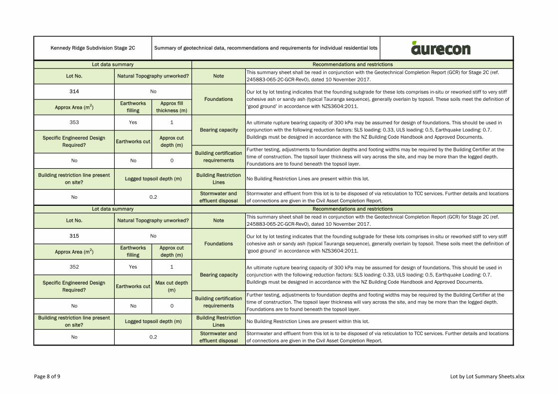
Lot No. Natural Topography unworked? NoteThis summary sheet shall be read in conjunction with the Geotechnical Completion Report (GCR) for Stage 2C (ref. 245883-065-2C-GCR-Rev0), dated 10 November 2017.
314 No
FoundationsOur lot by lot testing indicates that the founding subgrade for these lots comprises in-situ or reworked stiff to very stiff cohesive ash or sandy ash (typical Tauranga sequence), generally overlain by topsoil. These soils meet the definition of ‘good ground’ in accordance with NZS3604:2011. Approx Area (m2)
Earthworks filling
Lot No. Natural Topography unworked? NoteThis summary sheet shall be read in conjunction with the Geotechnical Completion Report (GCR) for Stage 2C (ref. 245883-065-2C-GCR-Rev0), dated 10 November 2017.
315 No
FoundationsOur lot by lot testing indicates that the founding subgrade for these lots comprises in-situ or reworked stiff to very stiff cohesive ash or sandy ash (typical Tauranga sequence), generally overlain by topsoil. These soils meet the definition of ‘good ground’ in accordance with NZS3604:2011. Approx Area (m2)
Earthworks filling
No 0.2Stormwater and effluent disposal
Stormwater and effluent from this lot is to be disposed of via reticulation to TCC services. Further details and locations of connections are given in the Civil Asset Completion Report.
Lot data summary Recommendations and restrictions
Further testing, adjustments to foundation depths and footing widths may be required by the Building Certifier at the time of construction. The topsoil layer thickness will vary across the site, and may be more than the logged depth. Foundations are to found beneath the topsoil layer.
No No 0
Building restriction line present on site?
Logged topsoil depth (m)Building Restriction
LinesNo Building Restriction Lines are present within this lot.
No 0.2Stormwater and effluent disposal
Stormwater and effluent from this lot is to be disposed of via reticulation to TCC services. Further details and locations of connections are given in the Civil Asset Completion Report.
Further testing, adjustments to foundation depths and footing widths may be required by the Building Certifier at the time of construction. The topsoil layer thickness will vary across the site, and may be more than the logged depth. Foundations are to found beneath the topsoil layer.
No No 0
Building restriction line present on site?
Logged topsoil depth (m)Building Restriction
LinesNo Building Restriction Lines are present within this lot.
Approx cut depth (m)
352 Yes 1
Bearing capacityAn ultimate rupture bearing capacity of 300 kPa may be assumed for design of foundations. This should be used in conjunction with the following reduction factors: SLS loading: 0.33, ULS loading: 0.5, Earthquake Loading: 0.7. Buildings must be designed in accordance with the NZ Building Code Handbook and Approved Documents.Specific Engineered Design
Required?Earthworks cut
Max cut depth (m)
Building certification requirements
Page 8 of 9 Lot by Lot Summary Sheets.xlsx
Kennedy Ridge Subdivision Stage 2C Summary of geotechnical data, recommendations and requirements for individual residential lots
Lot data summary Recommendations and restrictions
Approx fill thickness (m)
352 Yes 0.5
Bearing capacityAn ultimate rupture bearing capacity of 300 kPa may be assumed for design of foundations. This should be used in conjunction with the following reduction factors: SLS loading: 0.33, ULS loading: 0.5, Earthquake Loading: 0.7. Buildings must be designed in accordance with the NZ Building Code Handbook and Approved Documents.Specific Engineered Design
Required?Earthworks cut
Approx cut depth (m)
Building certification requirements
Lot No. Natural Topography unworked? NoteThis summary sheet shall be read in conjunction with the Geotechnical Completion Report (GCR) for Stage 2C (ref. 245883-065-2C-GCR-Rev0), dated 10 November 2017.
316 No
FoundationsOur lot by lot testing indicates that the founding subgrade for these lots comprises in-situ or reworked stiff to very stiff cohesive ash or sandy ash (typical Tauranga sequence), generally overlain by topsoil. These soils meet the definition of ‘good ground’ in accordance with NZS3604:2011. Approx Area (m2)
Earthworks filling
Lot No. Natural Topography unworked? NoteThis summary sheet shall be read in conjunction with the Geotechnical Completion Report (GCR) for Stage 2C (ref. 245883-065-2C-GCR-Rev0), dated 10 November 2017.
317 No
FoundationsOur lot by lot testing indicates that the founding subgrade for these lots comprises in-situ or reworked stiff to very stiff cohesive ash or sandy ash (typical Tauranga sequence), generally overlain by topsoil. These soils meet the definition of ‘good ground’ in accordance with NZS3604:2011. Approx Area (m2)
Earthworks filling
No 0.1Stormwater and effluent disposal
Stormwater and effluent from this lot is to be disposed of via reticulation to TCC services. Further details and locations of connections are given in the Civil Asset Completion Report.
Lot data summary Recommendations and restrictions
Further testing, adjustments to foundation depths and footing widths may be required by the Building Certifier at the time of construction. The topsoil layer thickness will vary across the site, and may be more than the logged depth. Foundations are to found beneath the topsoil layer.
No No 0
Building restriction line present on site?
Logged topsoil depth (m)Building Restriction
LinesNo Building Restriction Lines are present within this lot.
No 0.1Stormwater and effluent disposal
Stormwater and effluent from this lot is to be disposed of via reticulation to TCC services. Further details and locations of connections are given in the Civil Asset Completion Report.
Further testing, adjustments to foundation depths and footing widths may be required by the Building Certifier at the time of construction. The topsoil layer thickness will vary across the site, and may be more than the logged depth. Foundations are to found beneath the topsoil layer.
No Yes 2
Building restriction line present on site?
Logged topsoil depth (m)Building Restriction
LinesNo Building Restriction Lines are present within this lot.
Approx fill thickness (m)
352 No 0
Bearing capacityAn ultimate rupture bearing capacity of 300 kPa may be assumed for design of foundations. This should be used in conjunction with the following reduction factors: SLS loading: 0.33, ULS loading: 0.5, Earthquake Loading: 0.7. Buildings must be designed in accordance with the NZ Building Code Handbook and Approved Documents.Specific Engineered Design
Required?Earthworks cut
Approx cut depth (m)
Building certification requirements
Page 9 of 9 Lot by Lot Summary Sheets.xlsx

Appendix BSite plans

Appendix B Site plans

58.0
58.0
58.0
58.0
58.0
60.0
60.0
60.0
60.0
60.0
62.0
62.0
62.0
62.0
62.0
62.0
64.0
66.0
56.0
58.0
60.0
60.0
62.0
56.0
58.0
60.0
60.0
60.0
60.0
62.0
62.0
62.0
62.0
64.0
64.0
64.0
66.0
66.0
66.0
66.0
68.0
68.0
226
227
229
235
237
236
238
239
240
241
242
246
248
249
250
225
228
244
247
234DP 511944 233
DP 511944 232DP 511944 231
DP 511944 230DP 511944 224
DP 511944
223DP 511944 423
DP 509088 438DP 509088
1002DP 511944
780DP 501173
58DP 486181
57DP 486181
56DP 486181
55DP 486181
54DP 486181
53DP 486181
52DP 486181
934 D
P 48
618151
DP 486181
SECTION 3SO 440742
SECTION 2SO 416677
SECTION 2SO 440742
2DPS 53649
422
BLACKLOCK ROAD
PENETAKA HEIGHTS
TE R
ANGA
MEM
ORIA
L DRI
VE
WAG
HORN
STR
EET
5000(RECREATION
RESERVE)
TCC RESERVOIR
300
301
302
305
306
307
308
316
317
314
315
312
313
311
309
310
303
304
LEGENDPRE-DEVELOPMENT MAJORCONTOUR AT 2.0m INTERVALS
PRE-DEVELOPMENT MAJORCONTOUR AT 0.5m INTERVALS
49.0
CLIENT
DATE
TITLE
REVISION DETAILSDATEREV APPROVED
CHECKED
APPROVED
PROJECT
DRAWN
DESIGNED
PROJECT No. TYPE REVWBS DISC NUMBER
DRAWING No.
SCALE SIZE
A1
.PARADISO HOLDINGS LTD
KENNEDY ROAD SUBDIVISIONPYES PA - TAURANGA
GEOTECHNICAL COMPLETION REPORTSTAGE 2C - PRE-DEVELOPMENT LANDFORM PLAN
245883 065 DRG G 0010 A
1:500FOR INFORMATIONNOT FOR CONSTRUCTION
L.O'SULLIVAN
S.WEBBER
D.SANDILANDS R.GRIFFITHS
R.Griffiths13.11.17
A 13.11.17 GEOTECHNICAL COMPLETION REPORT ISSUE R.Griffiths
Filen
ame:
Plot
Date:
Offic
e:P:
\PRO
JECT
S\24
5883
- KE
NNED
Y RO
AD D
EVEL
OPME
NT\C
ADD\
DRGS
\GET
\STA
GE 2C
\2458
83-0
65-D
RG-(S
TAGE
2C G
CR)-G
-001
0.DW
G13
/11/20
17 3:
16:35
p.m.
NZTR
G
0
SCALE 1:500
5 10 20m
NOTES1. VERTICAL DATUM: MOTURIKI 1953 ORIGIN OF
LEVELS TCC BM1024 (RL 45.515m).2. HORIZONTAL DATUM: NZGD2000 BAY OF PLENTY.3. BOUNDARIES ARE IN TERMS OF DP505005.4. SURVEYED IN 2015 BY AURECON.5. CONTRACTOR WAIOTAHI CONTRACTORS LTD.
RELIC LANDSLIDE SCARP
226
227
229
235
237
236
238
239
240
241
242
248
249
250
225
228
244
247
234DP 511944 233
DP 511944 232DP 511944 231
DP 511944 230DP 511944 224
DP 511944
223DP 511944 423
DP 509088 438DP 509088
1002DP 511944
780DP 501173
58DP 486181
57DP 486181
56DP 486181
55DP 486181
54DP 486181
53DP 486181
52DP 486181
934 D
P 48
618151
DP 486181
SECTION 3SO 440742
SECTION 2SO 416677
SECTION 2SO 440742
2DPS 53649
422
BLACKLOCK ROAD
PENETAKA HEIGHTS
TE R
ANGA
MEM
ORIA
L DRI
VE
WAG
HORN
STR
EET
5000(RECREATION
RESERVE)
TCC RESERVOIR
300
301
302
305
306
307
308
316
317
314
315
312
313
311
309
310
303
304
-2.00
-1.50
0.00
0.50
0.50
0.501.00
1.00
1.00
1.00
1.50
1.50
1.50
1.50
1.50
NDM 211NDM 212
NDM 213
NDM 133NDM 80
NDM 122NDM 132
NDM 117NDM 81 NDM 134
NDM 120
NDM 116
NDM 131
NDM 115NDM 79
NDM 135
NDM 61
NDM 52
NDM 62NDM 53
NDM 51
NDM 130
NDM 119
NDM 136NDM 50
NDM 60
NDM 63
NDM 49
NDM 118
ST1ST2
ST3ST4ST5
ST6
INDICATIVE CUT CONTOUR AT0.5m INTERVALS
INDICATIVE FILL CONTOUR AT0.5m INTERVALS
INDICATIVE ZERO CUT/FILLCONTOUR
LEGEND
-0.50
0.0
1.00
CLIENT
DATE
TITLE
REVISION DETAILSDATEREV APPROVED
CHECKED
APPROVED
PROJECT
DRAWN
DESIGNED
PROJECT No. TYPE REVWBS DISC NUMBER
DRAWING No.
SCALE SIZE
A1
.PARADISO HOLDINGS LTD
KENNEDY ROAD SUBDIVISIONPYES PA - TAURANGA
GEOTECHNICAL COMPLETION REPORTSTAGE 2C - CUT FILL PLAN
245883 065 DRG G 0011 A
1:500FOR INFORMATIONNOT FOR CONSTRUCTION
L.O'SULLIVAN
S.WEBBER
D.SANDILANDS R.GRIFFITHS
R.Griffiths13.11.17
A 13.11.17 GEOTECHNICAL COMPLETION REPORT ISSUE R.Griffiths
Filen
ame:
Plot
Date:
Offic
e:P:
\PRO
JECT
S\24
5883
- KE
NNED
Y RO
AD D
EVEL
OPME
NT\C
ADD\
DRGS
\GET
\STA
GE 2C
\2458
83-0
65-D
RG-(S
TAGE
2C G
CR)-G
-001
1.DW
G13
/11/20
17 3:
16:41
p.m.
NZTR
G
0
SCALE 1:500
5 10 20m
NOTES1. THE CUT FILL CONTOURS ARE INDICATIVE ONLY AND MAY
NOT ACCURATELY REPRESENT CUT AND FILL DEPTHS.CUT FILL CONTOURS ARE BASED ON THE DIFFERENCEBETWEEN THE AURECON 10.10.17 AND 17.10.17 FINALLANDFORM (DRG G-0010) AND THE AURECON 2015PRE-DEVELOPMENT LANDFORM (DRG G-0012).
2. VERTICAL DATUM: MOTURIKI 1953 ORIGIN OF LEVELS BPIIDP 511944 (RL 61.16m).
3. HORIZONTAL DATUM: NZGD2000 BAY OF PLENTY.4. BOUNDARIES ARE IN TERMS OF DP505005.5. ST TESTS WERE COMPLETED BY HIGGINS CONTRACTORS.6. NDM TESTS WERE COMPLETED BY OPUS LABORATORIES.
NDM TEST LOCATION
SHEAR TEST (ST) LOCATION
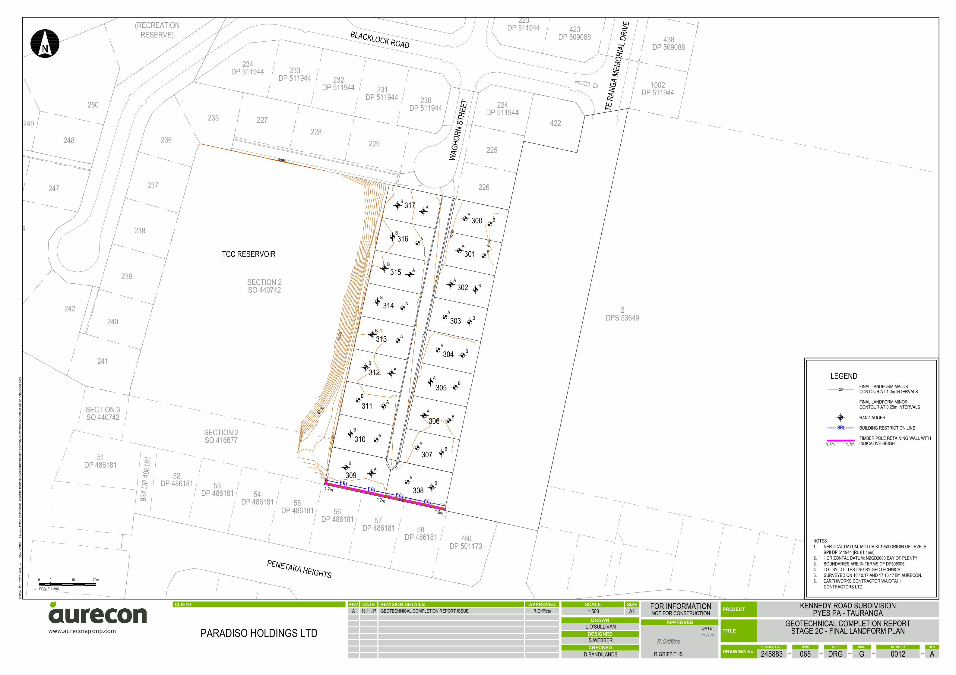
226
227
229
235
237
236
238
239
240
241
242
248
249
250
225
228
244
247
234DP 511944 233
DP 511944 232DP 511944 231
DP 511944 230DP 511944 224
DP 511944
223DP 511944 423
DP 509088 438DP 509088
1002DP 511944
780DP 501173
58DP 486181
57DP 486181
56DP 486181
55DP 486181
54DP 486181
53DP 486181
52DP 486181
934 D
P 48
618151
DP 486181
SECTION 3SO 440742
SECTION 2SO 416677
SECTION 2SO 440742
2DPS 53649
422
BLACKLOCK ROAD
PENETAKA HEIGHTS
TE R
ANGA
MEM
ORIA
L DRI
VE
WAG
HORN
STR
EET
5000(RECREATION
RESERVE)
TCC RESERVOIR
300
301
302
305
306
307
308
316
317
314
315
312
313
311
309
310
303
304
64
61.0061.00
61.00
62.00
62.00
64.00
64.00
AB
AB
AB
AB
AB
AB
AB
AB
AB
AB
AB
AB
AB
AB
AB
AB
AB
AB
1.7m
1.7m
1.8m
LEGENDFINAL LANDFORM MAJORCONTOUR AT 1.0m INTERVALS
FINAL LANDFORM MINORCONTOUR AT 0.25m INTERVALS
26
CLIENT
DATE
TITLE
REVISION DETAILSDATEREV APPROVED
CHECKED
APPROVED
PROJECT
DRAWN
DESIGNED
PROJECT No. TYPE REVWBS DISC NUMBER
DRAWING No.
SCALE SIZE
A1
.PARADISO HOLDINGS LTD
KENNEDY ROAD SUBDIVISIONPYES PA - TAURANGA
GEOTECHNICAL COMPLETION REPORTSTAGE 2C - FINAL LANDFORM PLAN
245883 065 DRG G 0012 A
1:500FOR INFORMATIONNOT FOR CONSTRUCTION
L.O'SULLIVAN
S.WEBBER
D.SANDILANDS R.GRIFFITHS
R.Griffiths13.11.17
A 13.11.17 GEOTECHNICAL COMPLETION REPORT ISSUE R.Griffiths
Filen
ame:
Plot
Date:
Offic
e:P:
\PRO
JECT
S\24
5883
- KE
NNED
Y RO
AD D
EVEL
OPME
NT\C
ADD\
DRGS
\GET
\STA
GE 2C
\2458
83-0
65-D
RG-(S
TAGE
2C G
CR)-G
-001
2.DW
G13
/11/20
17 3:
16:48
p.m.
NZTR
G
0
SCALE 1:500
5 10 20m
NOTES1. VERTICAL DATUM: MOTURIKI 1953 ORIGIN OF LEVELS
BPII DP 511944 (RL 61.16m).2. HORIZONTAL DATUM: NZGD2000 BAY OF PLENTY.3. BOUNDARIES ARE IN TERMS OF DP505005.4. LOT BY LOT TESTING BY GEOTECHNICS.5. SURVEYED ON 10.10.17 AND 17.10.17 BY AURECON.6. EARTHWORKS CONTRACTOR WAIOTAHI
CONTRACTORS LTD.
HAND AUGER
BUILDING RESTRICTION LINE
TIMBER POLE RETAINING WALL WITHINDICATIVE HEIGHT1.7m 1.7m


Appendix CEarthworks compliance
testing reports
Appendix C Earthworks compliance testing reports
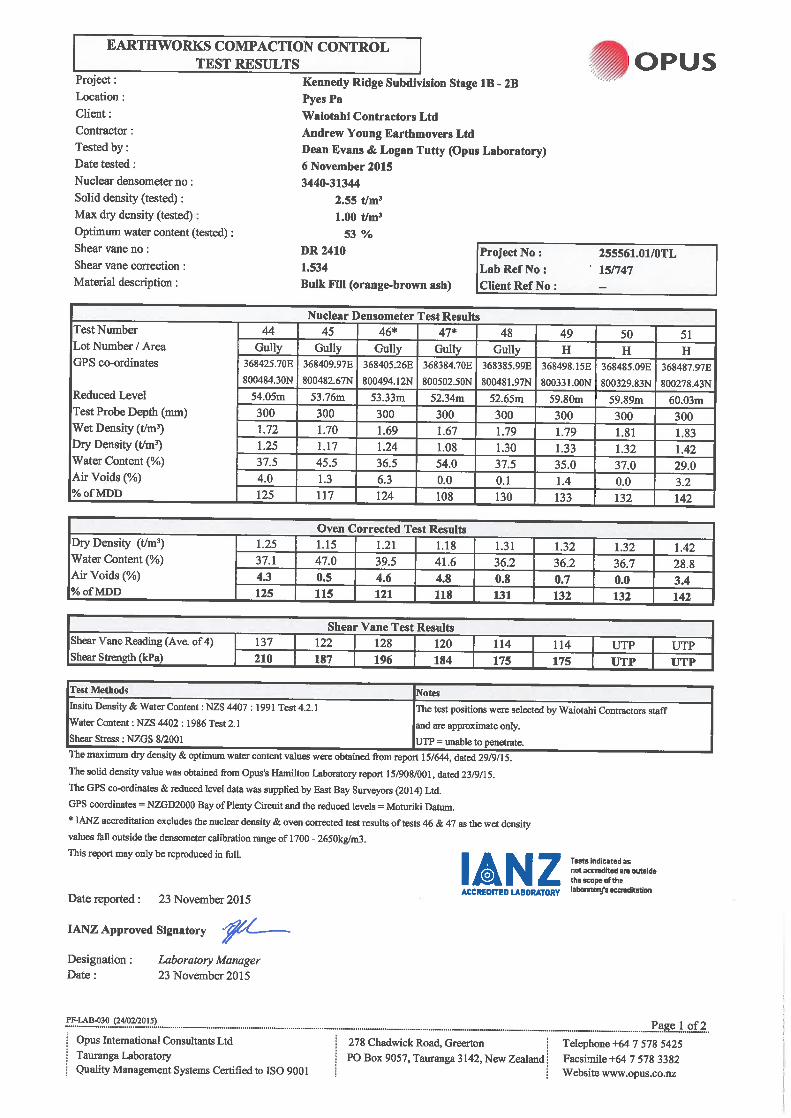
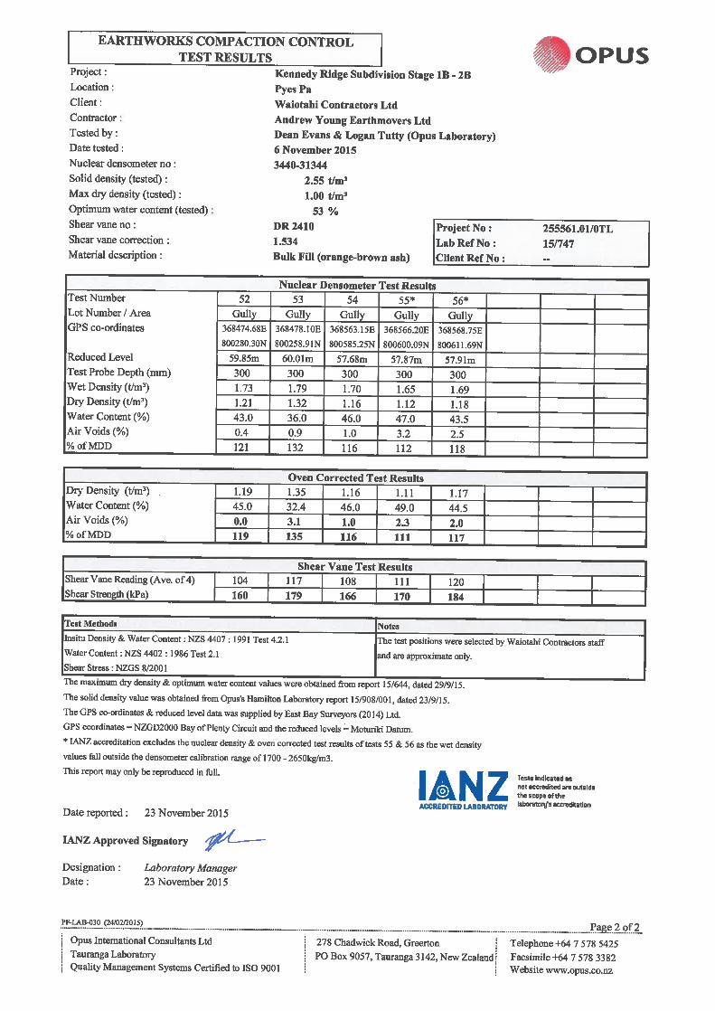
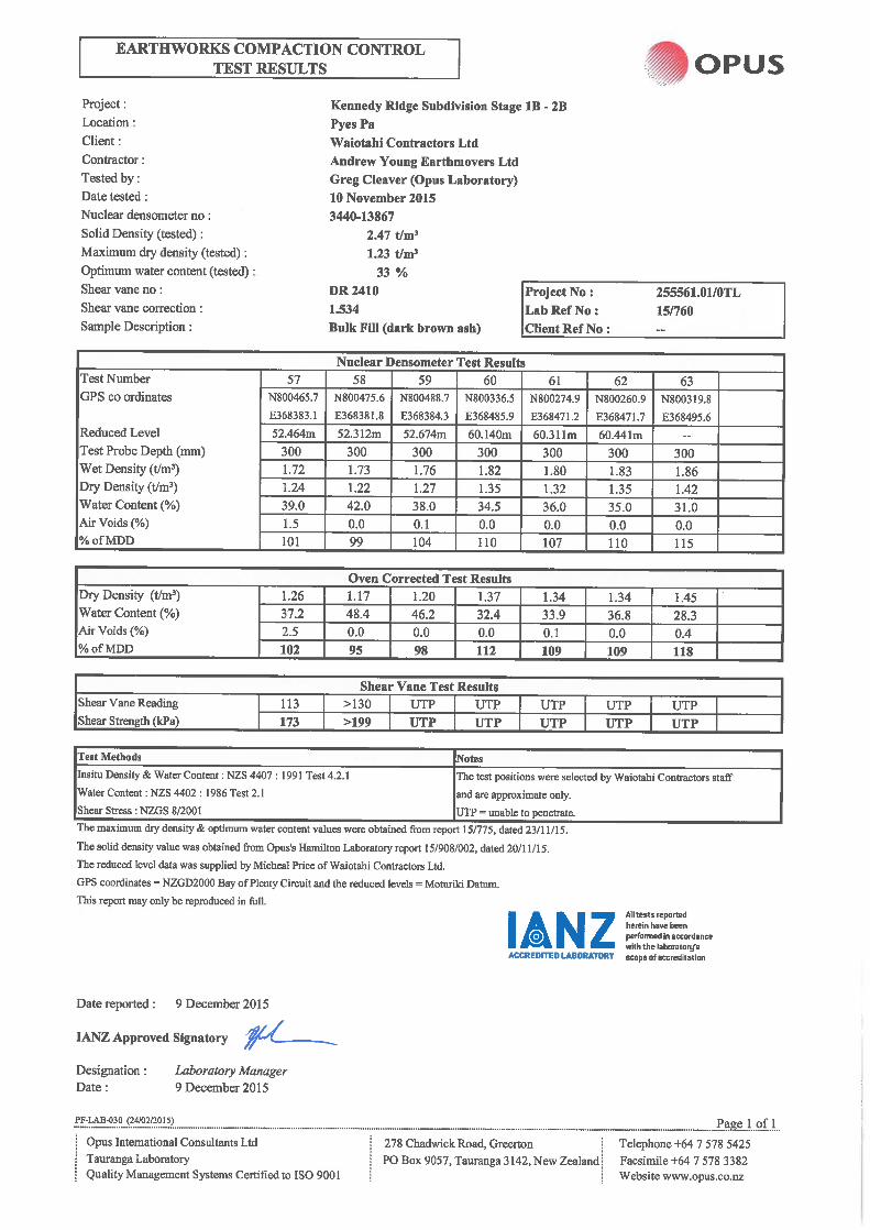

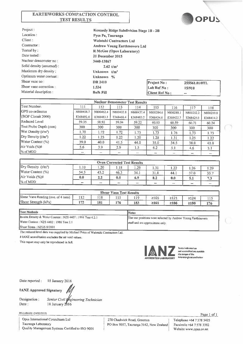
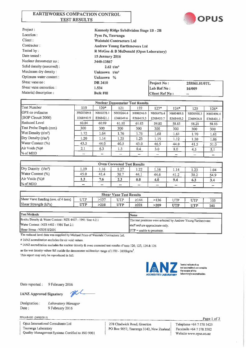
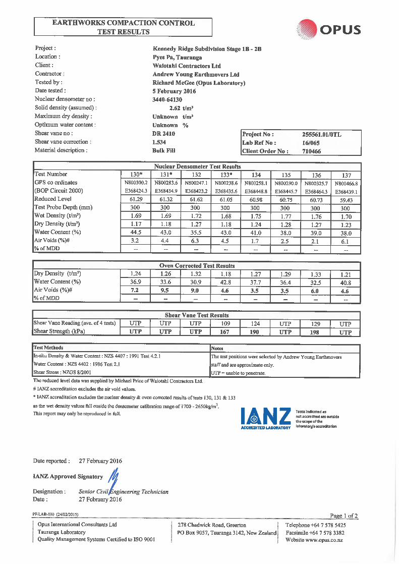

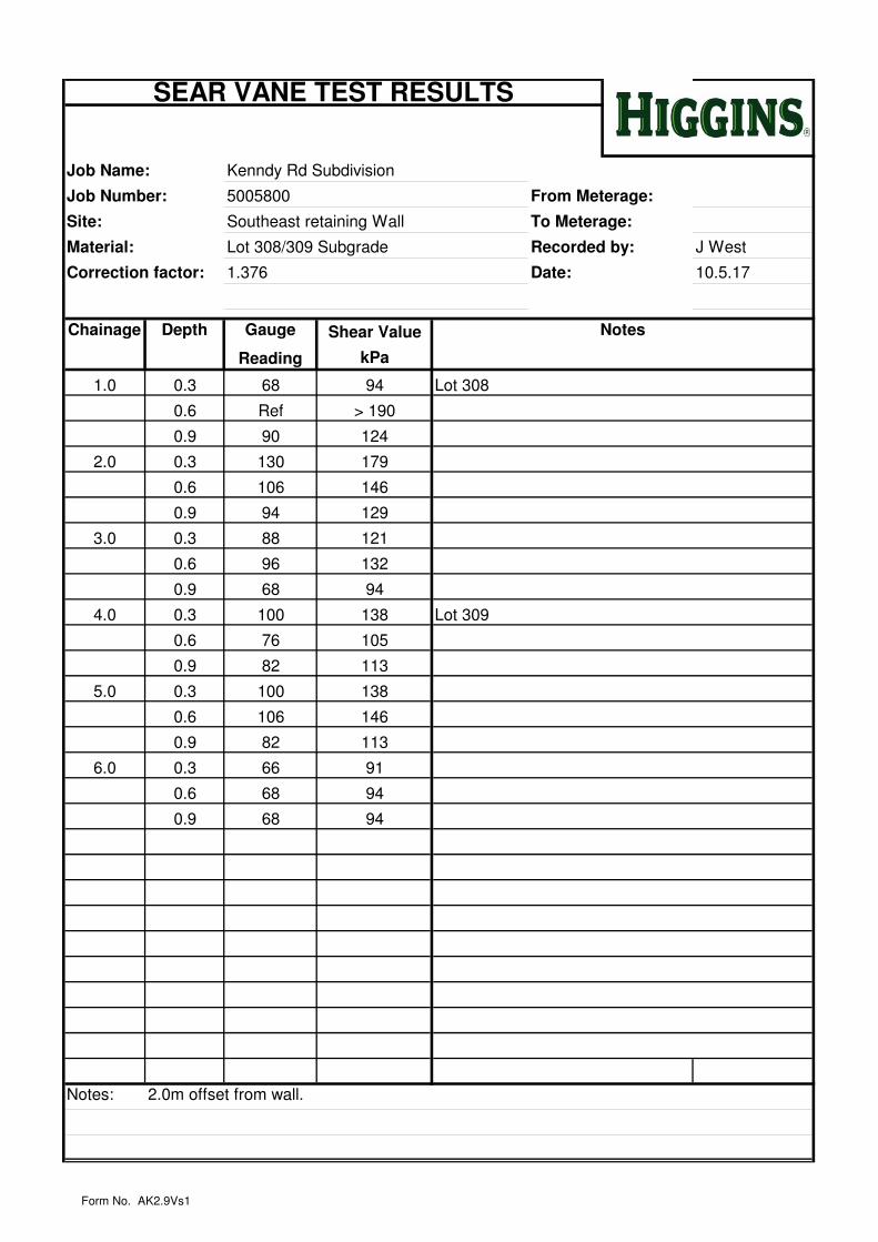
Job Name: Kenndy Rd Subdivision
Job Number: 5005800 From Meterage:
Site: Southeast retaining Wall To Meterage:
Material: Lot 308/309 Subgrade Recorded by: J West
Correction factor: 1.376 Date: 10.5.17
Chainage
(m)
Depth Shear Value
kPa
1.0 0.3 68 94 Lot 308
0.6 Ref > 190
0.9 90 124
2.0 0.3 130 179
0.6 106 146
0.9 94 129
3.0 0.3 88 121
0.6 96 132
0.9 68 94
4.0 0.3 100 138 Lot 309
0.6 76 105
0.9 82 113
5.0 0.3 100 138
0.6 106 146
0.9 82 113
6.0 0.3 66 91
0.6 68 94
0.9 68 94
Notes: 2.0m offset from wall.
Gauge
Reading
SEAR VANE TEST RESULTS
Notes
Form No. AK2.9Vs1


Appendix DLot by lot ground testing
Appendix D Lot by lot ground testing
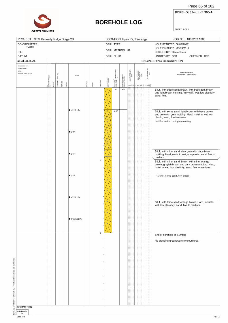
Bore
Log -
24/1
0/2
017 9
:03:2
8 A
M -
Pro
duce
d w
ith C
ore
-GS
by
GeR
oc
v3.1
e
SHEET: 1 OF 1
BOREHOLE No.: Lot 300-A
PROJECT: GTG Kennedy Ridge Stage 2B LOCATION: Pyes Pa, Tauranga JOB No.: 1003262.1000
GEOLOGICAL
WA
TE
R
DE
FE
CT
SP
AC
ING
(cm
)
BOREHOLE LOG
GEOLOGICAL UNIT,
GENERIC NAME,
ORIGIN,
MATERIAL COMPOSITION.
SA
MP
LE
S
ENGINEERING DESCRIPTION
20
60
200
600
2000F
LU
ID L
OS
S (
%)
25
50
75
DE
PT
H (
m)
GR
AP
HIC
LO
G
RL
(m
)
ME
TH
OD
CO
RE
RE
CO
VE
RY
(%
)
TESTS
CA
SIN
G
WE
AT
HE
RIN
GM
OIS
TU
RE
CO
ND
ITIO
N
ST
RE
NG
TH
/DE
NS
ITY
CL
AS
SIF
ICA
TIO
N
SH
EA
R S
TR
EN
GT
H(k
Pa
)
CO
MP
RE
SS
IVE
ST
RE
NG
TH
(MP
a)
1 5 20
50
100
250
10
25
50
100
200
CO-ORDINATES:(NZTM)
R.L.:
DATUM: DRILL FLUID:
DRILL METHOD: HA
DRILL TYPE:
DRILLED BY: Geotechnics
CHECKED: DFBLOGGED BY: DFB
HOLE FINISHED: 06/09/2017
HOLE STARTED: 06/09/2017
Description andAdditional Observations
1
2
>222 kPa
UTP
UTP
UTP
>222 kPa
210/38 kPa
SILT, with trace sand; brown, with trace dark brownand light brown mottling. Very stiff, wet, low plasticity;sand, fine.
SILT, with some sand; light brown with trace brownand brownish grey mottling. Hard, moist to wet, nonplastic; sand, fine to coarse.
SILT, with minor sand; dark grey with trace brownmottling. Hard, moist to wet, non plastic; sand, fine tomedium.
SILT, with minor sand; brown with minor orangebrown, greyish brown and dark brown mottling. Hard,moist to wet, low plasticity; sand, fine to medium.
SILT, with trace sand; orange brown. Hard, moist towet, low plasticity; sand, fine to medium.
End of borehole at 2.0mbgl.
No standing groundwater encountered.
0.55m: - minor dark grey mottling
1.30m: - some sand, non plastic
W
M-W
VSt
H
Hole Depth2m
COMMENTS:
Scale 1:15 Rev.: A
Page 65 of 102
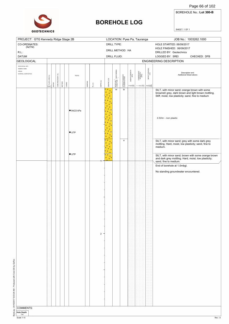
Bore
Log -
24/1
0/2
017 9
:03:2
8 A
M -
Pro
duce
d w
ith C
ore
-GS
by
GeR
oc
v3.1
e
SHEET: 1 OF 1
BOREHOLE No.: Lot 300-B
PROJECT: GTG Kennedy Ridge Stage 2B LOCATION: Pyes Pa, Tauranga JOB No.: 1003262.1000
GEOLOGICAL
WA
TE
R
DE
FE
CT
SP
AC
ING
(cm
)
BOREHOLE LOG
GEOLOGICAL UNIT,
GENERIC NAME,
ORIGIN,
MATERIAL COMPOSITION.
SA
MP
LE
S
ENGINEERING DESCRIPTION
20
60
200
600
2000F
LU
ID L
OS
S (
%)
25
50
75
DE
PT
H (
m)
GR
AP
HIC
LO
G
RL
(m
)
ME
TH
OD
CO
RE
RE
CO
VE
RY
(%
)
TESTS
CA
SIN
G
WE
AT
HE
RIN
GM
OIS
TU
RE
CO
ND
ITIO
N
ST
RE
NG
TH
/DE
NS
ITY
CL
AS
SIF
ICA
TIO
N
SH
EA
R S
TR
EN
GT
H(k
Pa
)
CO
MP
RE
SS
IVE
ST
RE
NG
TH
(MP
a)
1 5 20
50
100
250
10
25
50
100
200
CO-ORDINATES:(NZTM)
R.L.:
DATUM: DRILL FLUID:
DRILL METHOD: HA
DRILL TYPE:
DRILLED BY: Geotechnics
CHECKED: DFBLOGGED BY: SREI
HOLE FINISHED: 06/09/2017
HOLE STARTED: 06/09/2017
Description andAdditional Observations
1
2
94/23 kPa
UTP
UTP
SILT, with minor sand; orange brown with somebrownish grey, dark brown and light brown mottling.Stiff, moist, low plasticity; sand, fine to medium
SILT, with minor sand; grey with some dark greymottling. Hard, moist, low plasticity; sand, fine tomedium.
SILT, with minor sand; brown with some orange brownand dark grey mottling. Hard, moist, low plasticity;sand, fine to medium.
End of borehole at 1.0mbgl.
No standing groundwater encountered.
0.50m: - non plastic
M St
H
Hole Depth1m
COMMENTS:
Scale 1:15 Rev.: A
Page 66 of 102
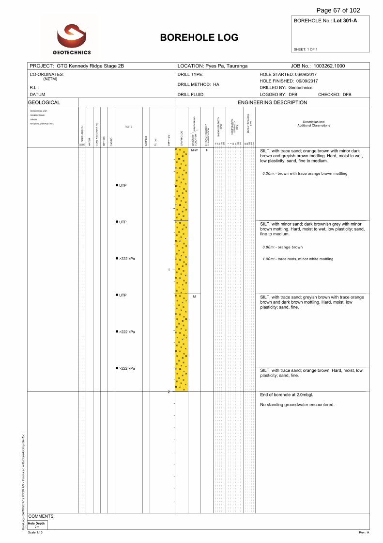
Bore
Log -
24/1
0/2
017 9
:03:2
8 A
M -
Pro
duce
d w
ith C
ore
-GS
by
GeR
oc
v3.1
e
SHEET: 1 OF 1
BOREHOLE No.: Lot 301-A
PROJECT: GTG Kennedy Ridge Stage 2B LOCATION: Pyes Pa, Tauranga JOB No.: 1003262.1000
GEOLOGICAL
WA
TE
R
DE
FE
CT
SP
AC
ING
(cm
)
BOREHOLE LOG
GEOLOGICAL UNIT,
GENERIC NAME,
ORIGIN,
MATERIAL COMPOSITION.
SA
MP
LE
S
ENGINEERING DESCRIPTION
20
60
200
600
2000F
LU
ID L
OS
S (
%)
25
50
75
DE
PT
H (
m)
GR
AP
HIC
LO
G
RL
(m
)
ME
TH
OD
CO
RE
RE
CO
VE
RY
(%
)
TESTS
CA
SIN
G
WE
AT
HE
RIN
GM
OIS
TU
RE
CO
ND
ITIO
N
ST
RE
NG
TH
/DE
NS
ITY
CL
AS
SIF
ICA
TIO
N
SH
EA
R S
TR
EN
GT
H(k
Pa
)
CO
MP
RE
SS
IVE
ST
RE
NG
TH
(MP
a)
1 5 20
50
100
250
10
25
50
100
200
CO-ORDINATES:(NZTM)
R.L.:
DATUM: DRILL FLUID:
DRILL METHOD: HA
DRILL TYPE:
DRILLED BY: Geotechnics
CHECKED: DFBLOGGED BY: DFB
HOLE FINISHED: 06/09/2017
HOLE STARTED: 06/09/2017
Description andAdditional Observations
1
2
UTP
UTP
>222 kPa
UTP
>222 kPa
>222 kPa
SILT, with trace sand; orange brown with minor darkbrown and greyish brown mottling. Hard, moist to wet,low plasticity; sand, fine to medium.
SILT, with minor sand; dark brownish grey with minorbrown mottling. Hard, moist to wet, low plasticity; sand,fine to medium.
SILT, with trace sand; greyish brown with trace orangebrown and dark brown mottling. Hard, moist, lowplasticity; sand, fine.
SILT, with trace sand; orange brown. Hard, moist, lowplasticity; sand, fine.
End of borehole at 2.0mbgl.
No standing groundwater encountered.
0.30m: - brown with trace orange brown mottling
0.80m: - orange brown
1.00m: - trace roots, minor white mottling
M-W
M
H
Hole Depth2m
COMMENTS:
Scale 1:15 Rev.: A
Page 67 of 102
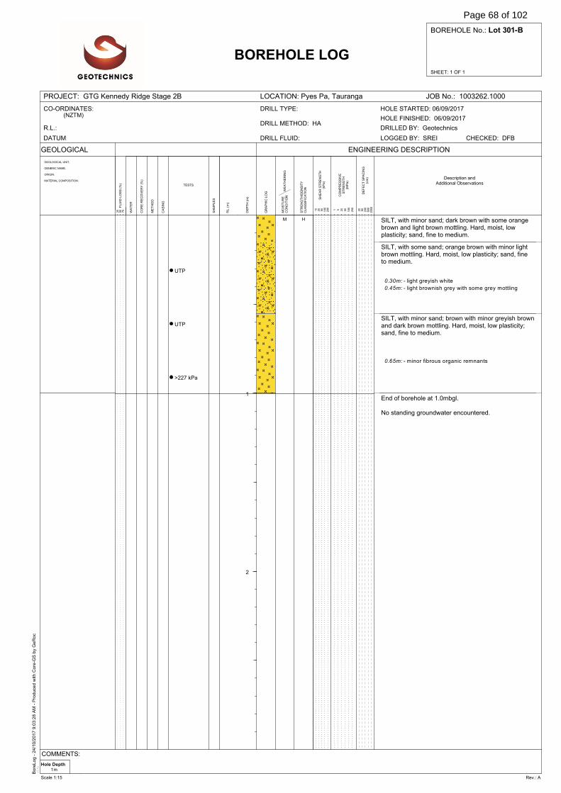
Bore
Log -
24/1
0/2
017 9
:03:2
8 A
M -
Pro
duce
d w
ith C
ore
-GS
by
GeR
oc
v3.1
e
SHEET: 1 OF 1
BOREHOLE No.: Lot 301-B
PROJECT: GTG Kennedy Ridge Stage 2B LOCATION: Pyes Pa, Tauranga JOB No.: 1003262.1000
GEOLOGICAL
WA
TE
R
DE
FE
CT
SP
AC
ING
(cm
)
BOREHOLE LOG
GEOLOGICAL UNIT,
GENERIC NAME,
ORIGIN,
MATERIAL COMPOSITION.
SA
MP
LE
S
ENGINEERING DESCRIPTION
20
60
200
600
2000F
LU
ID L
OS
S (
%)
25
50
75
DE
PT
H (
m)
GR
AP
HIC
LO
G
RL
(m
)
ME
TH
OD
CO
RE
RE
CO
VE
RY
(%
)
TESTS
CA
SIN
G
WE
AT
HE
RIN
GM
OIS
TU
RE
CO
ND
ITIO
N
ST
RE
NG
TH
/DE
NS
ITY
CL
AS
SIF
ICA
TIO
N
SH
EA
R S
TR
EN
GT
H(k
Pa
)
CO
MP
RE
SS
IVE
ST
RE
NG
TH
(MP
a)
1 5 20
50
100
250
10
25
50
100
200
CO-ORDINATES:(NZTM)
R.L.:
DATUM: DRILL FLUID:
DRILL METHOD: HA
DRILL TYPE:
DRILLED BY: Geotechnics
CHECKED: DFBLOGGED BY: SREI
HOLE FINISHED: 06/09/2017
HOLE STARTED: 06/09/2017
Description andAdditional Observations
1
2
UTP
UTP
>227 kPa
SILT, with minor sand; dark brown with some orangebrown and light brown mottling. Hard, moist, lowplasticity; sand, fine to medium.
SILT, with some sand; orange brown with minor lightbrown mottling. Hard, moist, low plasticity; sand, fineto medium.
SILT, with minor sand; brown with minor greyish brownand dark brown mottling. Hard, moist, low plasticity;sand, fine to medium.
End of borehole at 1.0mbgl.
No standing groundwater encountered.
0.30m: - light greyish white
0.45m: - light brownish grey with some grey mottling
0.65m: - minor fibrous organic remnants
M H
Hole Depth1m
COMMENTS:
Scale 1:15 Rev.: A
Page 68 of 102
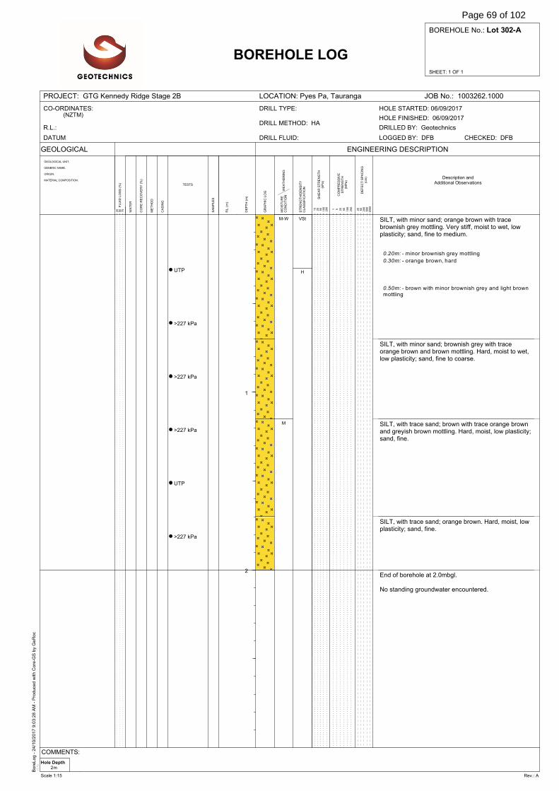
Bore
Log -
24/1
0/2
017 9
:03:2
8 A
M -
Pro
duce
d w
ith C
ore
-GS
by
GeR
oc
v3.1
e
SHEET: 1 OF 1
BOREHOLE No.: Lot 302-A
PROJECT: GTG Kennedy Ridge Stage 2B LOCATION: Pyes Pa, Tauranga JOB No.: 1003262.1000
GEOLOGICAL
WA
TE
R
DE
FE
CT
SP
AC
ING
(cm
)
BOREHOLE LOG
GEOLOGICAL UNIT,
GENERIC NAME,
ORIGIN,
MATERIAL COMPOSITION.
SA
MP
LE
S
ENGINEERING DESCRIPTION
20
60
200
600
2000F
LU
ID L
OS
S (
%)
25
50
75
DE
PT
H (
m)
GR
AP
HIC
LO
G
RL
(m
)
ME
TH
OD
CO
RE
RE
CO
VE
RY
(%
)
TESTS
CA
SIN
G
WE
AT
HE
RIN
GM
OIS
TU
RE
CO
ND
ITIO
N
ST
RE
NG
TH
/DE
NS
ITY
CL
AS
SIF
ICA
TIO
N
SH
EA
R S
TR
EN
GT
H(k
Pa
)
CO
MP
RE
SS
IVE
ST
RE
NG
TH
(MP
a)
1 5 20
50
100
250
10
25
50
100
200
CO-ORDINATES:(NZTM)
R.L.:
DATUM: DRILL FLUID:
DRILL METHOD: HA
DRILL TYPE:
DRILLED BY: Geotechnics
CHECKED: DFBLOGGED BY: DFB
HOLE FINISHED: 06/09/2017
HOLE STARTED: 06/09/2017
Description andAdditional Observations
1
2
UTP
>227 kPa
>227 kPa
>227 kPa
UTP
>227 kPa
SILT, with minor sand; orange brown with tracebrownish grey mottling. Very stiff, moist to wet, lowplasticity; sand, fine to medium.
SILT, with minor sand; brownish grey with traceorange brown and brown mottling. Hard, moist to wet,low plasticity; sand, fine to coarse.
SILT, with trace sand; brown with trace orange brownand greyish brown mottling. Hard, moist, low plasticity;sand, fine.
SILT, with trace sand; orange brown. Hard, moist, lowplasticity; sand, fine.
End of borehole at 2.0mbgl.
No standing groundwater encountered.
0.20m: - minor brownish grey mottling
0.30m: - orange brown, hard
0.50m: - brown with minor brownish grey and light brownmottling
M-W
M
VSt
H
Hole Depth2m
COMMENTS:
Scale 1:15 Rev.: A
Page 69 of 102
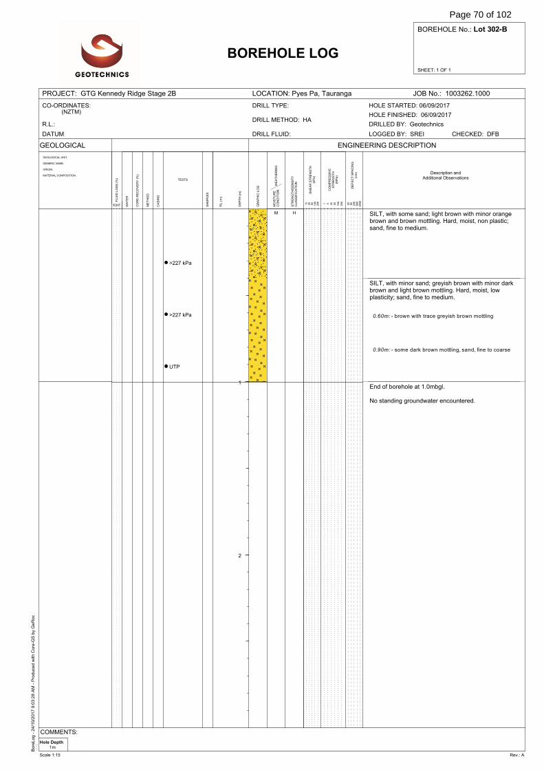
Bore
Log -
24/1
0/2
017 9
:03:2
8 A
M -
Pro
duce
d w
ith C
ore
-GS
by
GeR
oc
v3.1
e
SHEET: 1 OF 1
BOREHOLE No.: Lot 302-B
PROJECT: GTG Kennedy Ridge Stage 2B LOCATION: Pyes Pa, Tauranga JOB No.: 1003262.1000
GEOLOGICAL
WA
TE
R
DE
FE
CT
SP
AC
ING
(cm
)
BOREHOLE LOG
GEOLOGICAL UNIT,
GENERIC NAME,
ORIGIN,
MATERIAL COMPOSITION.
SA
MP
LE
S
ENGINEERING DESCRIPTION
20
60
200
600
2000F
LU
ID L
OS
S (
%)
25
50
75
DE
PT
H (
m)
GR
AP
HIC
LO
G
RL
(m
)
ME
TH
OD
CO
RE
RE
CO
VE
RY
(%
)
TESTS
CA
SIN
G
WE
AT
HE
RIN
GM
OIS
TU
RE
CO
ND
ITIO
N
ST
RE
NG
TH
/DE
NS
ITY
CL
AS
SIF
ICA
TIO
N
SH
EA
R S
TR
EN
GT
H(k
Pa
)
CO
MP
RE
SS
IVE
ST
RE
NG
TH
(MP
a)
1 5 20
50
100
250
10
25
50
100
200
CO-ORDINATES:(NZTM)
R.L.:
DATUM: DRILL FLUID:
DRILL METHOD: HA
DRILL TYPE:
DRILLED BY: Geotechnics
CHECKED: DFBLOGGED BY: SREI
HOLE FINISHED: 06/09/2017
HOLE STARTED: 06/09/2017
Description andAdditional Observations
1
2
>227 kPa
>227 kPa
UTP
SILT, with some sand; light brown with minor orangebrown and brown mottling. Hard, moist, non plastic;sand, fine to medium.
SILT, with minor sand; greyish brown with minor darkbrown and light brown mottling. Hard, moist, lowplasticity; sand, fine to medium.
End of borehole at 1.0mbgl.
No standing groundwater encountered.
0.60m: - brown with trace greyish brown mottling
0.90m: - some dark brown mottling, sand, fine to coarse
M H
Hole Depth1m
COMMENTS:
Scale 1:15 Rev.: A
Page 70 of 102
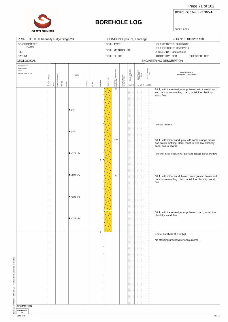
Bore
Log -
24/1
0/2
017 9
:03:2
8 A
M -
Pro
duce
d w
ith C
ore
-GS
by
GeR
oc
v3.1
e
SHEET: 1 OF 1
BOREHOLE No.: Lot 303-A
PROJECT: GTG Kennedy Ridge Stage 2B LOCATION: Pyes Pa, Tauranga JOB No.: 1003262.1000
GEOLOGICAL
WA
TE
R
DE
FE
CT
SP
AC
ING
(cm
)
BOREHOLE LOG
GEOLOGICAL UNIT,
GENERIC NAME,
ORIGIN,
MATERIAL COMPOSITION.
SA
MP
LE
S
ENGINEERING DESCRIPTION
20
60
200
600
2000F
LU
ID L
OS
S (
%)
25
50
75
DE
PT
H (
m)
GR
AP
HIC
LO
G
RL
(m
)
ME
TH
OD
CO
RE
RE
CO
VE
RY
(%
)
TESTS
CA
SIN
G
WE
AT
HE
RIN
GM
OIS
TU
RE
CO
ND
ITIO
N
ST
RE
NG
TH
/DE
NS
ITY
CL
AS
SIF
ICA
TIO
N
SH
EA
R S
TR
EN
GT
H(k
Pa
)
CO
MP
RE
SS
IVE
ST
RE
NG
TH
(MP
a)
1 5 20
50
100
250
10
25
50
100
200
CO-ORDINATES:(NZTM)
R.L.:
DATUM: DRILL FLUID:
DRILL METHOD: HA
DRILL TYPE:
DRILLED BY: Geotechnics
CHECKED: DFBLOGGED BY: DFB
HOLE FINISHED: 06/09/2017
HOLE STARTED: 06/09/2017
Description andAdditional Observations
1
2
UTP
UTP
>222 kPa
>222 kPa
>222 kPa
>222 kPa
SILT, with trace sand; orange brown with trace brownand dark brown mottling. Hard, moist, low plasticity;sand, fine.
SILT, with minor sand; grey with some orange brownand brown mottling. Hard, moist to wet, low plasticity;sand, fine to coarse.
SILT, with minor sand; brown, trace greyish brown anddark brown mottling. Hard, moist, low plasticity; sand,fine.
SILT, with trace sand; orange brown. Hard, moist, lowplasticity; sand, fine.
End of borehole at 2.0mbgl.
No standing groundwater encountered.
0.60m: - brown
0.90m: - brown with minor grey and orange brown mottling
M
M-W
M
H
Hole Depth2m
COMMENTS:
Scale 1:15 Rev.: A
Page 71 of 102
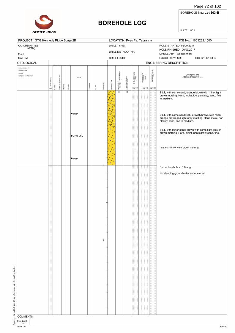
Bore
Log -
24/1
0/2
017 9
:03:2
8 A
M -
Pro
duce
d w
ith C
ore
-GS
by
GeR
oc
v3.1
e
SHEET: 1 OF 1
BOREHOLE No.: Lot 303-B
PROJECT: GTG Kennedy Ridge Stage 2B LOCATION: Pyes Pa, Tauranga JOB No.: 1003262.1000
GEOLOGICAL
WA
TE
R
DE
FE
CT
SP
AC
ING
(cm
)
BOREHOLE LOG
GEOLOGICAL UNIT,
GENERIC NAME,
ORIGIN,
MATERIAL COMPOSITION.
SA
MP
LE
S
ENGINEERING DESCRIPTION
20
60
200
600
2000F
LU
ID L
OS
S (
%)
25
50
75
DE
PT
H (
m)
GR
AP
HIC
LO
G
RL
(m
)
ME
TH
OD
CO
RE
RE
CO
VE
RY
(%
)
TESTS
CA
SIN
G
WE
AT
HE
RIN
GM
OIS
TU
RE
CO
ND
ITIO
N
ST
RE
NG
TH
/DE
NS
ITY
CL
AS
SIF
ICA
TIO
N
SH
EA
R S
TR
EN
GT
H(k
Pa
)
CO
MP
RE
SS
IVE
ST
RE
NG
TH
(MP
a)
1 5 20
50
100
250
10
25
50
100
200
CO-ORDINATES:(NZTM)
R.L.:
DATUM: DRILL FLUID:
DRILL METHOD: HA
DRILL TYPE:
DRILLED BY: Geotechnics
CHECKED: DFBLOGGED BY: SREI
HOLE FINISHED: 06/09/2017
HOLE STARTED: 06/09/2017
Description andAdditional Observations
1
2
UTP
>227 kPa
UTP
SILT, with some sand; orange brown with minor lightbrown mottling. Hard, moist, low plasticity; sand, fineto medium.
SILT, with some sand; light greyish brown with minororange brown and light grey mottling. Hard, moist, nonplastic; sand, fine to medium.
SILT, with minor sand; brown with some light greyishbrown mottling. Hard, moist, non plastic; sand, fine.
End of borehole at 1.0mbgl.
No standing groundwater encountered.
0.85m: - minor dark brown mottling
M H
Hole Depth1m
COMMENTS:
Scale 1:15 Rev.: A
Page 72 of 102
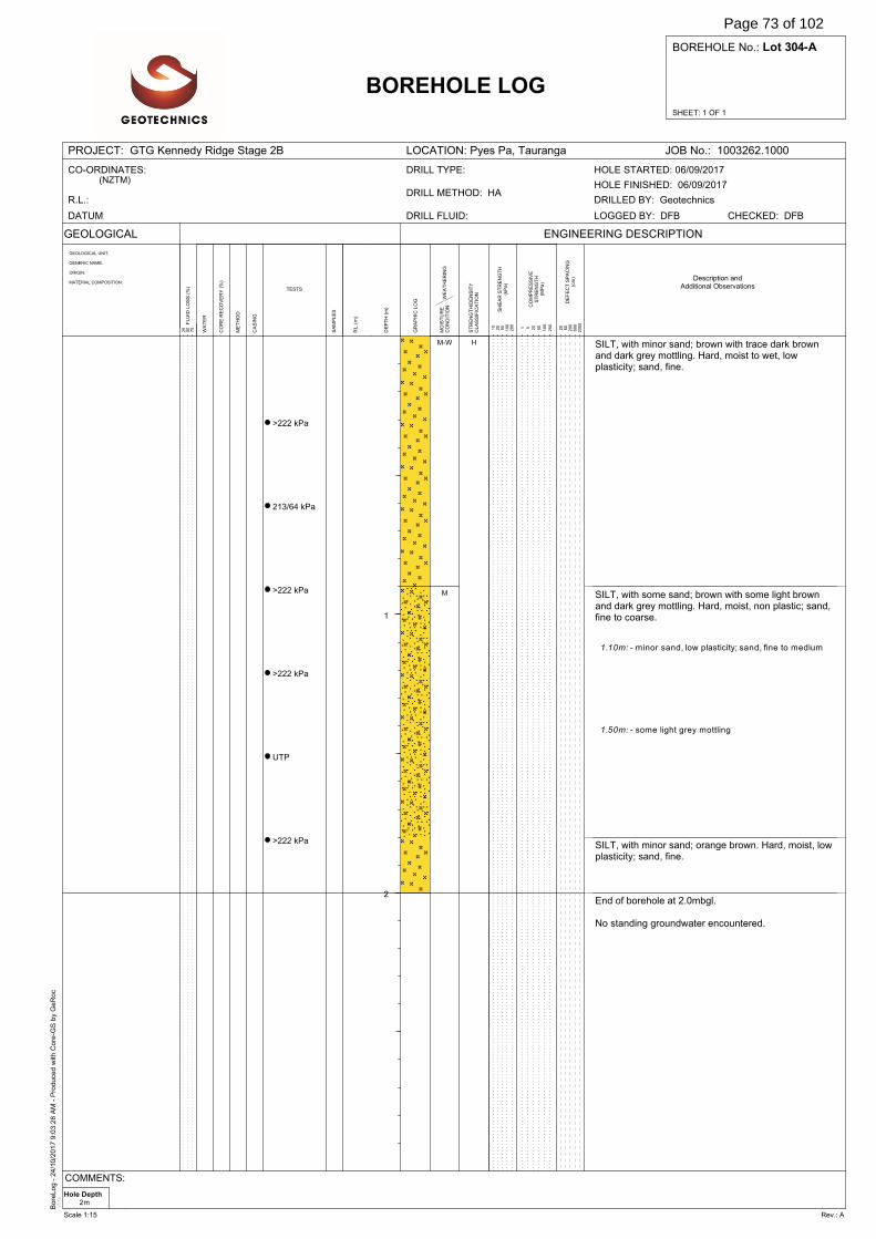
Bore
Log -
24/1
0/2
017 9
:03:2
8 A
M -
Pro
duce
d w
ith C
ore
-GS
by
GeR
oc
v3.1
e
SHEET: 1 OF 1
BOREHOLE No.: Lot 304-A
PROJECT: GTG Kennedy Ridge Stage 2B LOCATION: Pyes Pa, Tauranga JOB No.: 1003262.1000
GEOLOGICAL
WA
TE
R
DE
FE
CT
SP
AC
ING
(cm
)
BOREHOLE LOG
GEOLOGICAL UNIT,
GENERIC NAME,
ORIGIN,
MATERIAL COMPOSITION.
SA
MP
LE
S
ENGINEERING DESCRIPTION
20
60
200
600
2000F
LU
ID L
OS
S (
%)
25
50
75
DE
PT
H (
m)
GR
AP
HIC
LO
G
RL
(m
)
ME
TH
OD
CO
RE
RE
CO
VE
RY
(%
)
TESTS
CA
SIN
G
WE
AT
HE
RIN
GM
OIS
TU
RE
CO
ND
ITIO
N
ST
RE
NG
TH
/DE
NS
ITY
CL
AS
SIF
ICA
TIO
N
SH
EA
R S
TR
EN
GT
H(k
Pa
)
CO
MP
RE
SS
IVE
ST
RE
NG
TH
(MP
a)
1 5 20
50
100
250
10
25
50
100
200
CO-ORDINATES:(NZTM)
R.L.:
DATUM: DRILL FLUID:
DRILL METHOD: HA
DRILL TYPE:
DRILLED BY: Geotechnics
CHECKED: DFBLOGGED BY: DFB
HOLE FINISHED: 06/09/2017
HOLE STARTED: 06/09/2017
Description andAdditional Observations
1
2
>222 kPa
213/64 kPa
>222 kPa
>222 kPa
UTP
>222 kPa
SILT, with minor sand; brown with trace dark brownand dark grey mottling. Hard, moist to wet, lowplasticity; sand, fine.
SILT, with some sand; brown with some light brownand dark grey mottling. Hard, moist, non plastic; sand,fine to coarse.
SILT, with minor sand; orange brown. Hard, moist, lowplasticity; sand, fine.
End of borehole at 2.0mbgl.
No standing groundwater encountered.
1.10m: - minor sand, low plasticity; sand, fine to medium
1.50m: - some light grey mottling
M-W
M
H
Hole Depth2m
COMMENTS:
Scale 1:15 Rev.: A
Page 73 of 102

Bore
Log -
24/1
0/2
017 9
:03:2
8 A
M -
Pro
duce
d w
ith C
ore
-GS
by
GeR
oc
v3.1
e
SHEET: 1 OF 1
BOREHOLE No.: Lot 304-B
PROJECT: GTG Kennedy Ridge Stage 2B LOCATION: Pyes Pa, Tauranga JOB No.: 1003262.1000
GEOLOGICAL
WA
TE
R
DE
FE
CT
SP
AC
ING
(cm
)
BOREHOLE LOG
GEOLOGICAL UNIT,
GENERIC NAME,
ORIGIN,
MATERIAL COMPOSITION.
SA
MP
LE
S
ENGINEERING DESCRIPTION
20
60
200
600
2000F
LU
ID L
OS
S (
%)
25
50
75
DE
PT
H (
m)
GR
AP
HIC
LO
G
RL
(m
)
ME
TH
OD
CO
RE
RE
CO
VE
RY
(%
)
TESTS
CA
SIN
G
WE
AT
HE
RIN
GM
OIS
TU
RE
CO
ND
ITIO
N
ST
RE
NG
TH
/DE
NS
ITY
CL
AS
SIF
ICA
TIO
N
SH
EA
R S
TR
EN
GT
H(k
Pa
)
CO
MP
RE
SS
IVE
ST
RE
NG
TH
(MP
a)
1 5 20
50
100
250
10
25
50
100
200
CO-ORDINATES:(NZTM)
R.L.:
DATUM: DRILL FLUID:
DRILL METHOD: HA
DRILL TYPE:
DRILLED BY: Geotechnics
CHECKED: DFBLOGGED BY: SREI
HOLE FINISHED: 06/09/2017
HOLE STARTED: 06/09/2017
Description andAdditional Observations
1
2
>227 kPa
>227 kPa
UTP
SILT, with trace sand, trace rootlets; dark brownishblack. Stiff, moist, non plastic; sand, fine.
SILT, with some sand; brown with some orange brownand light brown mottling. Hard, moist, low plasticity;sand, fine to medium.
SILT, with minor sand; brown with some grey, lightbrown and dark grey mottling. Hard, moist, non plastic;sand, fine to medium.
End of borehole at 1.0mbgl.
No standing groundwater encountered.
0.30m: - non plastic
M St
H
Hole Depth1m
COMMENTS:
Scale 1:15 Rev.: A
Page 74 of 102

Bore
Log -
24/1
0/2
017 9
:03:2
8 A
M -
Pro
duce
d w
ith C
ore
-GS
by
GeR
oc
v3.1
e
SHEET: 1 OF 1
BOREHOLE No.: Lot 305-A
PROJECT: GTG Kennedy Ridge Stage 2B LOCATION: Pyes Pa, Tauranga JOB No.: 1003262.1000
GEOLOGICAL
WA
TE
R
DE
FE
CT
SP
AC
ING
(cm
)
BOREHOLE LOG
GEOLOGICAL UNIT,
GENERIC NAME,
ORIGIN,
MATERIAL COMPOSITION.
SA
MP
LE
S
ENGINEERING DESCRIPTION
20
60
200
600
2000F
LU
ID L
OS
S (
%)
25
50
75
DE
PT
H (
m)
GR
AP
HIC
LO
G
RL
(m
)
ME
TH
OD
CO
RE
RE
CO
VE
RY
(%
)
TESTS
CA
SIN
G
WE
AT
HE
RIN
GM
OIS
TU
RE
CO
ND
ITIO
N
ST
RE
NG
TH
/DE
NS
ITY
CL
AS
SIF
ICA
TIO
N
SH
EA
R S
TR
EN
GT
H(k
Pa
)
CO
MP
RE
SS
IVE
ST
RE
NG
TH
(MP
a)
1 5 20
50
100
250
10
25
50
100
200
CO-ORDINATES:(NZTM)
R.L.:
DATUM: DRILL FLUID:
DRILL METHOD: HA
DRILL TYPE:
DRILLED BY: Geotechnics
CHECKED: DFBLOGGED BY: DFB
HOLE FINISHED: 06/09/2017
HOLE STARTED: 06/09/2017
Description andAdditional Observations
1
2
UTP
>222 kPa
143/48 kPa
194/38 kPa
>222 kPa
UTP
SILT, with minor sand; orange brown with trace darkbrown mottling. Hard, moist, low plasticity; sand, fine.
SILT, with some clay, minor sand; brown with somedark brown mottling. Very stiff, moist to wet, lowplasticity; sand, fine to coarse.
SILT, with minor sand; dark grey with minor greymottling. Hard, moist to wet, low plasticity; sand, fine tomedium.
SILT, with trace sand; orange brown. Hard, moist, lowplasticity; sand, fine.
End of borehole at 2.0mbgl.
No standing groundwater encountered.
0.60m: - brown with minor dark brown and dark greymottling; sand, fine to medium
1.35 - 1.45m: - grey with trace brown mottling
M
M-W
M
H
VSt
H
Hole Depth2m
COMMENTS:
Scale 1:15 Rev.: A
Page 75 of 102
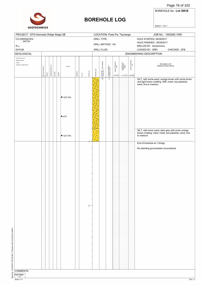
Bore
Log -
24/1
0/2
017 9
:03:2
8 A
M -
Pro
duce
d w
ith C
ore
-GS
by
GeR
oc
v3.1
e
SHEET: 1 OF 1
BOREHOLE No.: Lot 305-B
PROJECT: GTG Kennedy Ridge Stage 2B LOCATION: Pyes Pa, Tauranga JOB No.: 1003262.1000
GEOLOGICAL
WA
TE
R
DE
FE
CT
SP
AC
ING
(cm
)
BOREHOLE LOG
GEOLOGICAL UNIT,
GENERIC NAME,
ORIGIN,
MATERIAL COMPOSITION.
SA
MP
LE
S
ENGINEERING DESCRIPTION
20
60
200
600
2000F
LU
ID L
OS
S (
%)
25
50
75
DE
PT
H (
m)
GR
AP
HIC
LO
G
RL
(m
)
ME
TH
OD
CO
RE
RE
CO
VE
RY
(%
)
TESTS
CA
SIN
G
WE
AT
HE
RIN
GM
OIS
TU
RE
CO
ND
ITIO
N
ST
RE
NG
TH
/DE
NS
ITY
CL
AS
SIF
ICA
TIO
N
SH
EA
R S
TR
EN
GT
H(k
Pa
)
CO
MP
RE
SS
IVE
ST
RE
NG
TH
(MP
a)
1 5 20
50
100
250
10
25
50
100
200
CO-ORDINATES:(NZTM)
R.L.:
DATUM: DRILL FLUID:
DRILL METHOD: HA
DRILL TYPE:
DRILLED BY: Geotechnics
CHECKED: DFBLOGGED BY: SREI
HOLE FINISHED: 06/09/2017
HOLE STARTED: 06/09/2017
Description andAdditional Observations
1
2
>227 kPa
UTP
>227 kPa
SILT, with some sand; orange brown with some brownand light brown mottling. Stiff, moist, low plasticity;sand, fine to medium.
SILT, with minor sand; dark grey with some orangebrown mottling. Hard, moist, low plasticity; sand, fineto medium.
End of borehole at 1.0mbgl.
No standing groundwater encountered.
M H
Hole Depth1m
COMMENTS:
Scale 1:15 Rev.: A
Page 76 of 102
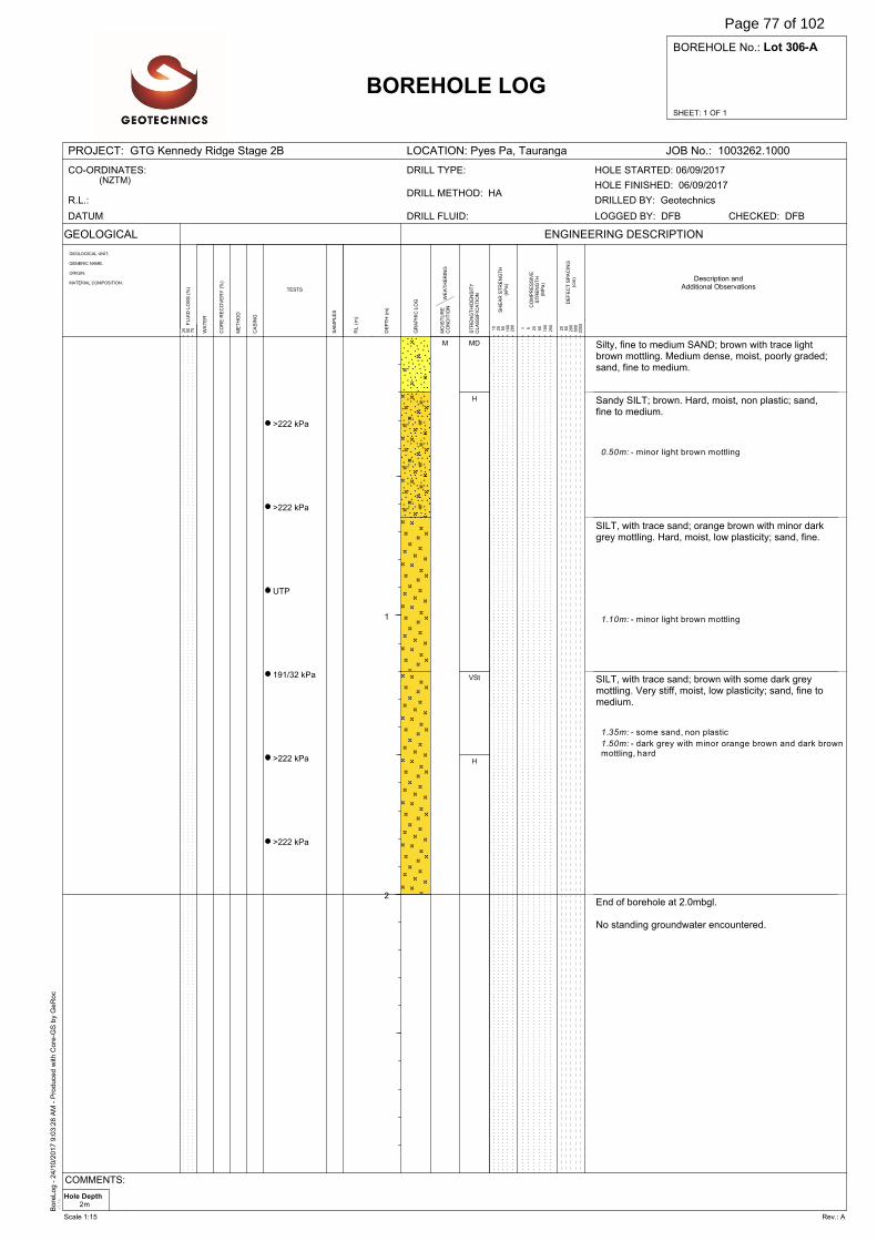
Bore
Log -
24/1
0/2
017 9
:03:2
8 A
M -
Pro
duce
d w
ith C
ore
-GS
by
GeR
oc
v3.1
e
SHEET: 1 OF 1
BOREHOLE No.: Lot 306-A
PROJECT: GTG Kennedy Ridge Stage 2B LOCATION: Pyes Pa, Tauranga JOB No.: 1003262.1000
GEOLOGICAL
WA
TE
R
DE
FE
CT
SP
AC
ING
(cm
)
BOREHOLE LOG
GEOLOGICAL UNIT,
GENERIC NAME,
ORIGIN,
MATERIAL COMPOSITION.
SA
MP
LE
S
ENGINEERING DESCRIPTION
20
60
200
600
2000F
LU
ID L
OS
S (
%)
25
50
75
DE
PT
H (
m)
GR
AP
HIC
LO
G
RL
(m
)
ME
TH
OD
CO
RE
RE
CO
VE
RY
(%
)
TESTS
CA
SIN
G
WE
AT
HE
RIN
GM
OIS
TU
RE
CO
ND
ITIO
N
ST
RE
NG
TH
/DE
NS
ITY
CL
AS
SIF
ICA
TIO
N
SH
EA
R S
TR
EN
GT
H(k
Pa
)
CO
MP
RE
SS
IVE
ST
RE
NG
TH
(MP
a)
1 5 20
50
100
250
10
25
50
100
200
CO-ORDINATES:(NZTM)
R.L.:
DATUM: DRILL FLUID:
DRILL METHOD: HA
DRILL TYPE:
DRILLED BY: Geotechnics
CHECKED: DFBLOGGED BY: DFB
HOLE FINISHED: 06/09/2017
HOLE STARTED: 06/09/2017
Description andAdditional Observations
1
2
>222 kPa
>222 kPa
UTP
191/32 kPa
>222 kPa
>222 kPa
Silty, fine to medium SAND; brown with trace lightbrown mottling. Medium dense, moist, poorly graded;sand, fine to medium.
Sandy SILT; brown. Hard, moist, non plastic; sand,fine to medium.
SILT, with trace sand; orange brown with minor darkgrey mottling. Hard, moist, low plasticity; sand, fine.
SILT, with trace sand; brown with some dark greymottling. Very stiff, moist, low plasticity; sand, fine tomedium.
End of borehole at 2.0mbgl.
No standing groundwater encountered.
0.50m: - minor light brown mottling
1.10m: - minor light brown mottling
1.35m: - some sand, non plastic
1.50m: - dark grey with minor orange brown and dark brownmottling, hard
M MD
H
VSt
H
Hole Depth2m
COMMENTS:
Scale 1:15 Rev.: A
Page 77 of 102
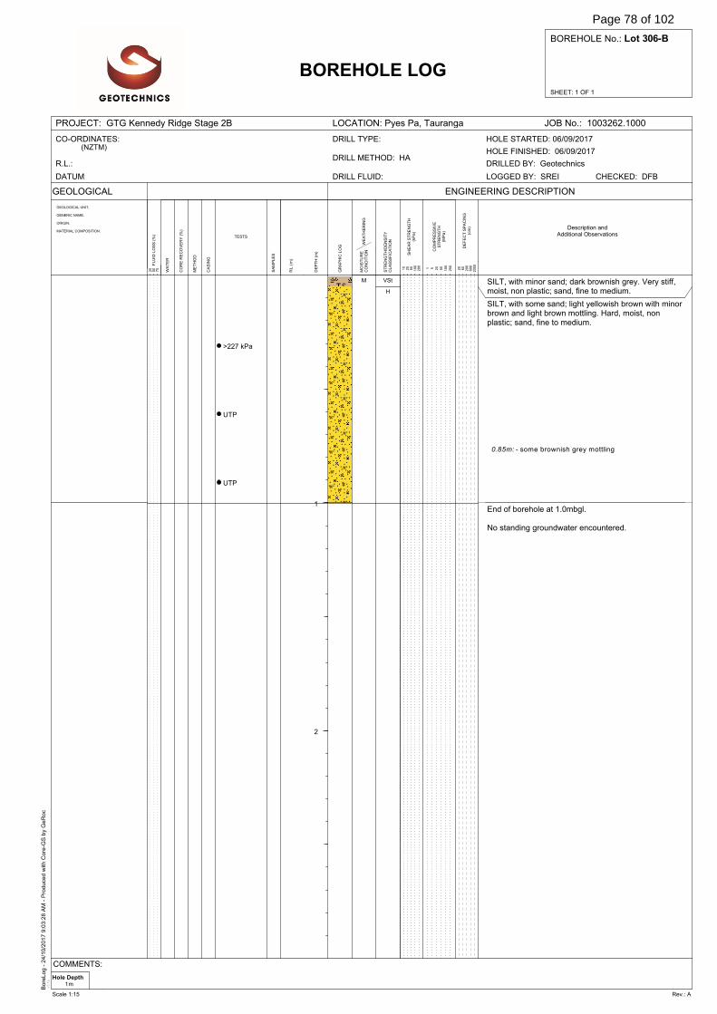
Bore
Log -
24/1
0/2
017 9
:03:2
8 A
M -
Pro
duce
d w
ith C
ore
-GS
by
GeR
oc
v3.1
e
SHEET: 1 OF 1
BOREHOLE No.: Lot 306-B
PROJECT: GTG Kennedy Ridge Stage 2B LOCATION: Pyes Pa, Tauranga JOB No.: 1003262.1000
GEOLOGICAL
WA
TE
R
DE
FE
CT
SP
AC
ING
(cm
)
BOREHOLE LOG
GEOLOGICAL UNIT,
GENERIC NAME,
ORIGIN,
MATERIAL COMPOSITION.
SA
MP
LE
S
ENGINEERING DESCRIPTION
20
60
200
600
2000F
LU
ID L
OS
S (
%)
25
50
75
DE
PT
H (
m)
GR
AP
HIC
LO
G
RL
(m
)
ME
TH
OD
CO
RE
RE
CO
VE
RY
(%
)
TESTS
CA
SIN
G
WE
AT
HE
RIN
GM
OIS
TU
RE
CO
ND
ITIO
N
ST
RE
NG
TH
/DE
NS
ITY
CL
AS
SIF
ICA
TIO
N
SH
EA
R S
TR
EN
GT
H(k
Pa
)
CO
MP
RE
SS
IVE
ST
RE
NG
TH
(MP
a)
1 5 20
50
100
250
10
25
50
100
200
CO-ORDINATES:(NZTM)
R.L.:
DATUM: DRILL FLUID:
DRILL METHOD: HA
DRILL TYPE:
DRILLED BY: Geotechnics
CHECKED: DFBLOGGED BY: SREI
HOLE FINISHED: 06/09/2017
HOLE STARTED: 06/09/2017
Description andAdditional Observations
1
2
>227 kPa
UTP
UTP
SILT, with minor sand; dark brownish grey. Very stiff,moist, non plastic; sand, fine to medium.
SILT, with some sand; light yellowish brown with minorbrown and light brown mottling. Hard, moist, nonplastic; sand, fine to medium.
End of borehole at 1.0mbgl.
No standing groundwater encountered.
0.85m: - some brownish grey mottling
M VSt
H
Hole Depth1m
COMMENTS:
Scale 1:15 Rev.: A
Page 78 of 102
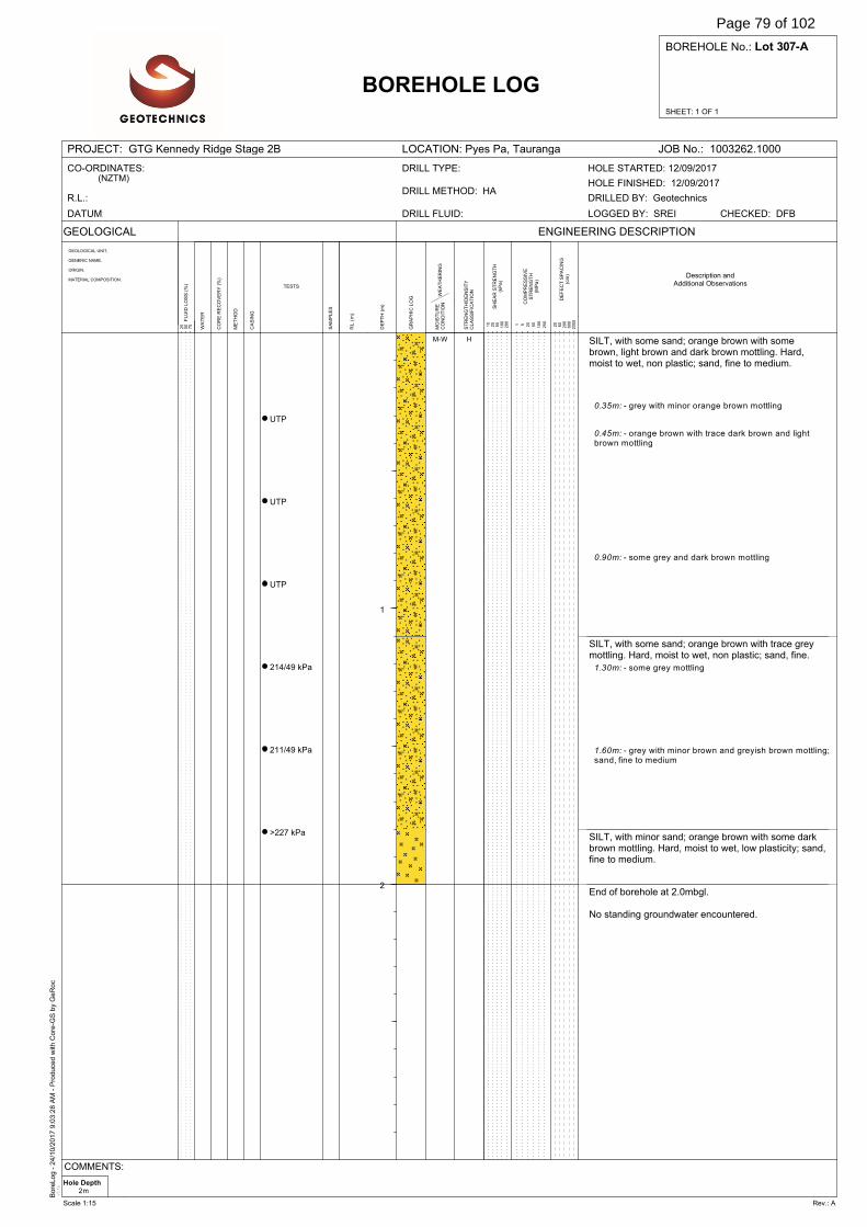
Bore
Log -
24/1
0/2
017 9
:03:2
8 A
M -
Pro
duce
d w
ith C
ore
-GS
by
GeR
oc
v3.1
e
SHEET: 1 OF 1
BOREHOLE No.: Lot 307-A
PROJECT: GTG Kennedy Ridge Stage 2B LOCATION: Pyes Pa, Tauranga JOB No.: 1003262.1000
GEOLOGICAL
WA
TE
R
DE
FE
CT
SP
AC
ING
(cm
)
BOREHOLE LOG
GEOLOGICAL UNIT,
GENERIC NAME,
ORIGIN,
MATERIAL COMPOSITION.
SA
MP
LE
S
ENGINEERING DESCRIPTION
20
60
200
600
2000F
LU
ID L
OS
S (
%)
25
50
75
DE
PT
H (
m)
GR
AP
HIC
LO
G
RL
(m
)
ME
TH
OD
CO
RE
RE
CO
VE
RY
(%
)
TESTS
CA
SIN
G
WE
AT
HE
RIN
GM
OIS
TU
RE
CO
ND
ITIO
N
ST
RE
NG
TH
/DE
NS
ITY
CL
AS
SIF
ICA
TIO
N
SH
EA
R S
TR
EN
GT
H(k
Pa
)
CO
MP
RE
SS
IVE
ST
RE
NG
TH
(MP
a)
1 5 20
50
100
250
10
25
50
100
200
CO-ORDINATES:(NZTM)
R.L.:
DATUM: DRILL FLUID:
DRILL METHOD: HA
DRILL TYPE:
DRILLED BY: Geotechnics
CHECKED: DFBLOGGED BY: SREI
HOLE FINISHED: 12/09/2017
HOLE STARTED: 12/09/2017
Description andAdditional Observations
1
2
UTP
UTP
UTP
214/49 kPa
211/49 kPa
>227 kPa
SILT, with some sand; orange brown with somebrown, light brown and dark brown mottling. Hard,moist to wet, non plastic; sand, fine to medium.
SILT, with some sand; orange brown with trace greymottling. Hard, moist to wet, non plastic; sand, fine.
SILT, with minor sand; orange brown with some darkbrown mottling. Hard, moist to wet, low plasticity; sand,fine to medium.
End of borehole at 2.0mbgl.
No standing groundwater encountered.
0.35m: - grey with minor orange brown mottling
0.45m: - orange brown with trace dark brown and lightbrown mottling
0.90m: - some grey and dark brown mottling
1.30m: - some grey mottling
1.60m: - grey with minor brown and greyish brown mottling;sand, fine to medium
M-W H
Hole Depth2m
COMMENTS:
Scale 1:15 Rev.: A
Page 79 of 102
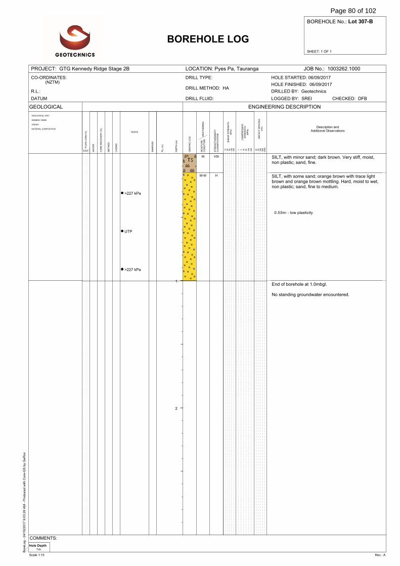
Bore
Log -
24/1
0/2
017 9
:03:2
8 A
M -
Pro
duce
d w
ith C
ore
-GS
by
GeR
oc
v3.1
e
SHEET: 1 OF 1
BOREHOLE No.: Lot 307-B
PROJECT: GTG Kennedy Ridge Stage 2B LOCATION: Pyes Pa, Tauranga JOB No.: 1003262.1000
GEOLOGICAL
WA
TE
R
DE
FE
CT
SP
AC
ING
(cm
)
BOREHOLE LOG
GEOLOGICAL UNIT,
GENERIC NAME,
ORIGIN,
MATERIAL COMPOSITION.
SA
MP
LE
S
ENGINEERING DESCRIPTION
20
60
200
600
2000F
LU
ID L
OS
S (
%)
25
50
75
DE
PT
H (
m)
GR
AP
HIC
LO
G
RL
(m
)
ME
TH
OD
CO
RE
RE
CO
VE
RY
(%
)
TESTS
CA
SIN
G
WE
AT
HE
RIN
GM
OIS
TU
RE
CO
ND
ITIO
N
ST
RE
NG
TH
/DE
NS
ITY
CL
AS
SIF
ICA
TIO
N
SH
EA
R S
TR
EN
GT
H(k
Pa
)
CO
MP
RE
SS
IVE
ST
RE
NG
TH
(MP
a)
1 5 20
50
100
250
10
25
50
100
200
CO-ORDINATES:(NZTM)
R.L.:
DATUM: DRILL FLUID:
DRILL METHOD: HA
DRILL TYPE:
DRILLED BY: Geotechnics
CHECKED: DFBLOGGED BY: SREI
HOLE FINISHED: 06/09/2017
HOLE STARTED: 06/09/2017
Description andAdditional Observations
1
2
>227 kPa
UTP
>227 kPa
SILT, with minor sand; dark brown. Very stiff, moist,non plastic; sand, fine.
SILT, with some sand; orange brown with trace lightbrown and orange brown mottling. Hard, moist to wet,non plastic; sand, fine to medium.
End of borehole at 1.0mbgl.
No standing groundwater encountered.
0.55m: - low plasticity
M
M-W
VSt
H
Hole Depth1m
COMMENTS:
Scale 1:15 Rev.: A
Page 80 of 102

Bore
Log -
24/1
0/2
017 9
:03:2
8 A
M -
Pro
duce
d w
ith C
ore
-GS
by
GeR
oc
v3.1
e
SHEET: 1 OF 1
BOREHOLE No.: Lot 308-A
PROJECT: GTG Kennedy Ridge Stage 2B LOCATION: Pyes Pa, Tauranga JOB No.: 1003262.1000
GEOLOGICAL
WA
TE
R
DE
FE
CT
SP
AC
ING
(cm
)
BOREHOLE LOG
GEOLOGICAL UNIT,
GENERIC NAME,
ORIGIN,
MATERIAL COMPOSITION.
SA
MP
LE
S
ENGINEERING DESCRIPTION
20
60
200
600
2000F
LU
ID L
OS
S (
%)
25
50
75
DE
PT
H (
m)
GR
AP
HIC
LO
G
RL
(m
)
ME
TH
OD
CO
RE
RE
CO
VE
RY
(%
)
TESTS
CA
SIN
G
WE
AT
HE
RIN
GM
OIS
TU
RE
CO
ND
ITIO
N
ST
RE
NG
TH
/DE
NS
ITY
CL
AS
SIF
ICA
TIO
N
SH
EA
R S
TR
EN
GT
H(k
Pa
)
CO
MP
RE
SS
IVE
ST
RE
NG
TH
(MP
a)
1 5 20
50
100
250
10
25
50
100
200
CO-ORDINATES:(NZTM)
R.L.:
DATUM: DRILL FLUID:
DRILL METHOD: HA
DRILL TYPE:
DRILLED BY: Geotechnics
CHECKED: DFBLOGGED BY: SREI
HOLE FINISHED: 12/09/2017
HOLE STARTED: 12/09/2017
Description andAdditional Observations
1
2
UTP
UTP
UTP
UTP
UTP
UTP
SILT, with some sand, trace gravel; orange brown withsome greyish brown mottling. Hard, moist to wet, nonplastic; gravel, fine, sub-rounded
SILT, with some sand, some clay; orange brown.Hard, moist to wet, low plasticity; sand, fine tomedium.
End of borehole at 2.0mbgl.
No standing groundwater encountered.
0.35m: - minor sand, low plasticity
M-W H
Hole Depth2m
COMMENTS:
Scale 1:15 Rev.: A
Page 81 of 102
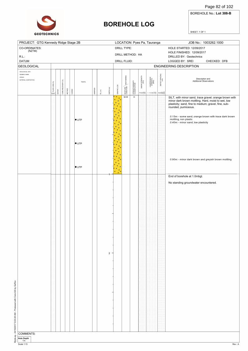
Bore
Log -
24/1
0/2
017 9
:03:2
8 A
M -
Pro
duce
d w
ith C
ore
-GS
by
GeR
oc
v3.1
e
SHEET: 1 OF 1
BOREHOLE No.: Lot 308-B
PROJECT: GTG Kennedy Ridge Stage 2B LOCATION: Pyes Pa, Tauranga JOB No.: 1003262.1000
GEOLOGICAL
WA
TE
R
DE
FE
CT
SP
AC
ING
(cm
)
BOREHOLE LOG
GEOLOGICAL UNIT,
GENERIC NAME,
ORIGIN,
MATERIAL COMPOSITION.
SA
MP
LE
S
ENGINEERING DESCRIPTION
20
60
200
600
2000F
LU
ID L
OS
S (
%)
25
50
75
DE
PT
H (
m)
GR
AP
HIC
LO
G
RL
(m
)
ME
TH
OD
CO
RE
RE
CO
VE
RY
(%
)
TESTS
CA
SIN
G
WE
AT
HE
RIN
GM
OIS
TU
RE
CO
ND
ITIO
N
ST
RE
NG
TH
/DE
NS
ITY
CL
AS
SIF
ICA
TIO
N
SH
EA
R S
TR
EN
GT
H(k
Pa
)
CO
MP
RE
SS
IVE
ST
RE
NG
TH
(MP
a)
1 5 20
50
100
250
10
25
50
100
200
CO-ORDINATES:(NZTM)
R.L.:
DATUM: DRILL FLUID:
DRILL METHOD: HA
DRILL TYPE:
DRILLED BY: Geotechnics
CHECKED: DFBLOGGED BY: SREI
HOLE FINISHED: 12/09/2017
HOLE STARTED: 12/09/2017
Description andAdditional Observations
1
2
UTP
UTP
UTP
SILT, with minor sand, trace gravel; orange brown withminor dark brown mottling. Hard, moist to wet, lowplasticity; sand, fine to medium; gravel, fine, sub-rounded, pumiceous.
End of borehole at 1.0mbgl.
No standing groundwater encountered.
0.15m: - some sand, orange brown with trace dark brownmottling, non plastic
0.40m: - minor sand, low plasticity
0.90m: - minor dark brown and greyish brown mottling
M-W H
Hole Depth1m
COMMENTS:
Scale 1:15 Rev.: A
Page 82 of 102
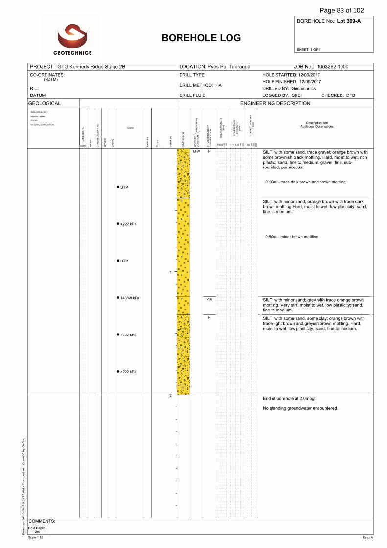
Bore
Log -
24/1
0/2
017 9
:03:2
8 A
M -
Pro
duce
d w
ith C
ore
-GS
by
GeR
oc
v3.1
e
SHEET: 1 OF 1
BOREHOLE No.: Lot 309-A
PROJECT: GTG Kennedy Ridge Stage 2B LOCATION: Pyes Pa, Tauranga JOB No.: 1003262.1000
GEOLOGICAL
WA
TE
R
DE
FE
CT
SP
AC
ING
(cm
)
BOREHOLE LOG
GEOLOGICAL UNIT,
GENERIC NAME,
ORIGIN,
MATERIAL COMPOSITION.
SA
MP
LE
S
ENGINEERING DESCRIPTION
20
60
200
600
2000F
LU
ID L
OS
S (
%)
25
50
75
DE
PT
H (
m)
GR
AP
HIC
LO
G
RL
(m
)
ME
TH
OD
CO
RE
RE
CO
VE
RY
(%
)
TESTS
CA
SIN
G
WE
AT
HE
RIN
GM
OIS
TU
RE
CO
ND
ITIO
N
ST
RE
NG
TH
/DE
NS
ITY
CL
AS
SIF
ICA
TIO
N
SH
EA
R S
TR
EN
GT
H(k
Pa
)
CO
MP
RE
SS
IVE
ST
RE
NG
TH
(MP
a)
1 5 20
50
100
250
10
25
50
100
200
CO-ORDINATES:(NZTM)
R.L.:
DATUM: DRILL FLUID:
DRILL METHOD: HA
DRILL TYPE:
DRILLED BY: Geotechnics
CHECKED: DFBLOGGED BY: SREI
HOLE FINISHED: 12/09/2017
HOLE STARTED: 12/09/2017
Description andAdditional Observations
1
2
UTP
>222 kPa
UTP
143/48 kPa
>222 kPa
>222 kPa
SILT, with some sand, trace gravel; orange brown withsome brownish black mottling. Hard, moist to wet, nonplastic; sand, fine to medium; gravel, fine, sub-rounded, pumiceous.
SILT, with minor sand; orange brown with trace darkbrown mottling.Hard, moist to wet, low plasticity; sand,fine to medium.
SILT, with minor sand; grey with trace orange brownmottling. Very stiff, moist to wet, low plasticity; sand,fine to medium.
SILT, with some sand, some clay; orange brown withtrace light brown and greyish brown mottling. Hard,moist to wet, low plasticity; sand, fine to medium.
End of borehole at 2.0mbgl.
No standing groundwater encountered.
0.10m: - trace dark brown and brown mottling
0.80m: - minor brown mottling
M-W H
VSt
H
Hole Depth2m
COMMENTS:
Scale 1:15 Rev.: A
Page 83 of 102
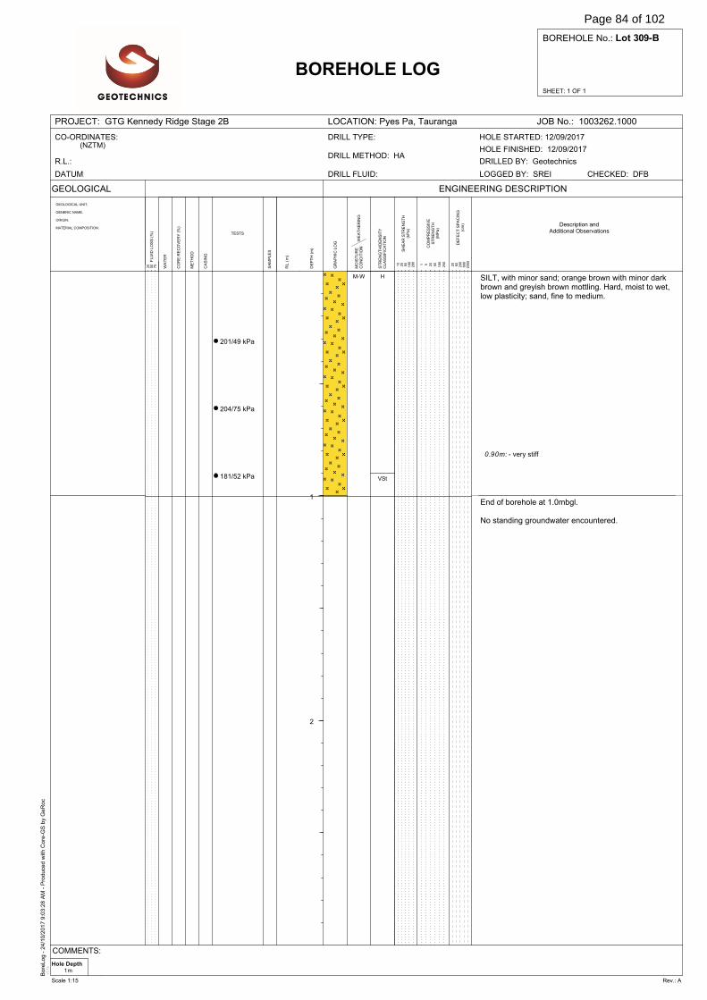
Bore
Log -
24/1
0/2
017 9
:03:2
8 A
M -
Pro
duce
d w
ith C
ore
-GS
by
GeR
oc
v3.1
e
SHEET: 1 OF 1
BOREHOLE No.: Lot 309-B
PROJECT: GTG Kennedy Ridge Stage 2B LOCATION: Pyes Pa, Tauranga JOB No.: 1003262.1000
GEOLOGICAL
WA
TE
R
DE
FE
CT
SP
AC
ING
(cm
)
BOREHOLE LOG
GEOLOGICAL UNIT,
GENERIC NAME,
ORIGIN,
MATERIAL COMPOSITION.
SA
MP
LE
S
ENGINEERING DESCRIPTION
20
60
200
600
2000F
LU
ID L
OS
S (
%)
25
50
75
DE
PT
H (
m)
GR
AP
HIC
LO
G
RL
(m
)
ME
TH
OD
CO
RE
RE
CO
VE
RY
(%
)
TESTS
CA
SIN
G
WE
AT
HE
RIN
GM
OIS
TU
RE
CO
ND
ITIO
N
ST
RE
NG
TH
/DE
NS
ITY
CL
AS
SIF
ICA
TIO
N
SH
EA
R S
TR
EN
GT
H(k
Pa
)
CO
MP
RE
SS
IVE
ST
RE
NG
TH
(MP
a)
1 5 20
50
100
250
10
25
50
100
200
CO-ORDINATES:(NZTM)
R.L.:
DATUM: DRILL FLUID:
DRILL METHOD: HA
DRILL TYPE:
DRILLED BY: Geotechnics
CHECKED: DFBLOGGED BY: SREI
HOLE FINISHED: 12/09/2017
HOLE STARTED: 12/09/2017
Description andAdditional Observations
1
2
201/49 kPa
204/75 kPa
181/52 kPa
SILT, with minor sand; orange brown with minor darkbrown and greyish brown mottling. Hard, moist to wet,low plasticity; sand, fine to medium.
End of borehole at 1.0mbgl.
No standing groundwater encountered.
0.90m: - very stiff
M-W H
VSt
Hole Depth1m
COMMENTS:
Scale 1:15 Rev.: A
Page 84 of 102
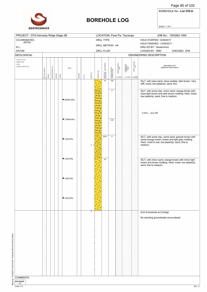
Bore
Log -
24/1
0/2
017 9
:03:2
8 A
M -
Pro
duce
d w
ith C
ore
-GS
by
GeR
oc
v3.1
e
SHEET: 1 OF 1
BOREHOLE No.: Lot 310-A
PROJECT: GTG Kennedy Ridge Stage 2B LOCATION: Pyes Pa, Tauranga JOB No.: 1003262.1000
GEOLOGICAL
WA
TE
R
DE
FE
CT
SP
AC
ING
(cm
)
BOREHOLE LOG
GEOLOGICAL UNIT,
GENERIC NAME,
ORIGIN,
MATERIAL COMPOSITION.
SA
MP
LE
S
ENGINEERING DESCRIPTION
20
60
200
600
2000F
LU
ID L
OS
S (
%)
25
50
75
DE
PT
H (
m)
GR
AP
HIC
LO
G
RL
(m
)
ME
TH
OD
CO
RE
RE
CO
VE
RY
(%
)
TESTS
CA
SIN
G
WE
AT
HE
RIN
GM
OIS
TU
RE
CO
ND
ITIO
N
ST
RE
NG
TH
/DE
NS
ITY
CL
AS
SIF
ICA
TIO
N
SH
EA
R S
TR
EN
GT
H(k
Pa
)
CO
MP
RE
SS
IVE
ST
RE
NG
TH
(MP
a)
1 5 20
50
100
250
10
25
50
100
200
CO-ORDINATES:(NZTM)
R.L.:
DATUM: DRILL FLUID:
DRILL METHOD: HA
DRILL TYPE:
DRILLED BY: Geotechnics
CHECKED: DFBLOGGED BY: SREI
HOLE FINISHED: 12/09/2017
HOLE STARTED: 12/09/2017
Description andAdditional Observations
1
2
203/64 kPa
178/48 kPa
>222 kPa
>222 kPa
>222 kPa
>222 kPa
SILT, with trace sand, trace rootlets; dark brown. Verystiff, moist, low plasticity; sand, fine.
SILT, with some clay, minor sand; orange brown withtrace light brown and dark brown mottling. Hard, moist,low plasticity; sand, fine to medium.
SILT, with some clay, some sand; greyish brown withsome orange brown, brown and light grey mottling.Hard, moist to wet, low plasticity; sand, fine tomedium.
SILT, with minor sand; orange brown with minor lightbrown and brown mottling. Hard, moist, low plasticity;sand, fine to medium.
End of borehole at 2.0mbgl.
No standing groundwater encountered.
0.60m: - very stiff
M
M-W
M
VSt
H
VSt
H
Hole Depth2m
COMMENTS:
Scale 1:15 Rev.: A
Page 85 of 102
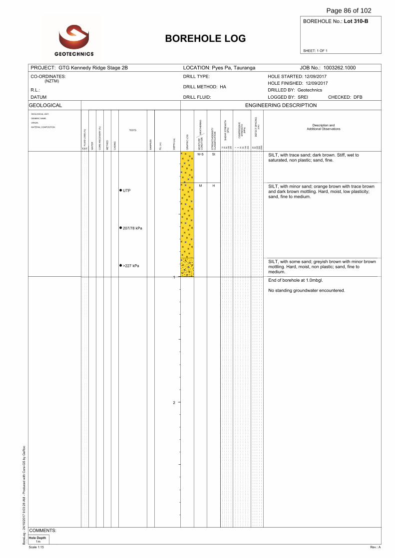
Bore
Log -
24/1
0/2
017 9
:03:2
8 A
M -
Pro
duce
d w
ith C
ore
-GS
by
GeR
oc
v3.1
e
SHEET: 1 OF 1
BOREHOLE No.: Lot 310-B
PROJECT: GTG Kennedy Ridge Stage 2B LOCATION: Pyes Pa, Tauranga JOB No.: 1003262.1000
GEOLOGICAL
WA
TE
R
DE
FE
CT
SP
AC
ING
(cm
)
BOREHOLE LOG
GEOLOGICAL UNIT,
GENERIC NAME,
ORIGIN,
MATERIAL COMPOSITION.
SA
MP
LE
S
ENGINEERING DESCRIPTION
20
60
200
600
2000F
LU
ID L
OS
S (
%)
25
50
75
DE
PT
H (
m)
GR
AP
HIC
LO
G
RL
(m
)
ME
TH
OD
CO
RE
RE
CO
VE
RY
(%
)
TESTS
CA
SIN
G
WE
AT
HE
RIN
GM
OIS
TU
RE
CO
ND
ITIO
N
ST
RE
NG
TH
/DE
NS
ITY
CL
AS
SIF
ICA
TIO
N
SH
EA
R S
TR
EN
GT
H(k
Pa
)
CO
MP
RE
SS
IVE
ST
RE
NG
TH
(MP
a)
1 5 20
50
100
250
10
25
50
100
200
CO-ORDINATES:(NZTM)
R.L.:
DATUM: DRILL FLUID:
DRILL METHOD: HA
DRILL TYPE:
DRILLED BY: Geotechnics
CHECKED: DFBLOGGED BY: SREI
HOLE FINISHED: 12/09/2017
HOLE STARTED: 12/09/2017
Description andAdditional Observations
1
2
UTP
207/78 kPa
>227 kPa
SILT, with trace sand; dark brown. Stiff, wet tosaturated, non plastic; sand, fine.
SILT, with minor sand; orange brown with trace brownand dark brown mottling. Hard, moist, low plasticity;sand, fine to medium.
SILT, with some sand; greyish brown with minor brownmottling. Hard, moist, non plastic; sand, fine tomedium.
End of borehole at 1.0mbgl.
No standing groundwater encountered.
W-S
M
St
H
Hole Depth1m
COMMENTS:
Scale 1:15 Rev.: A
Page 86 of 102
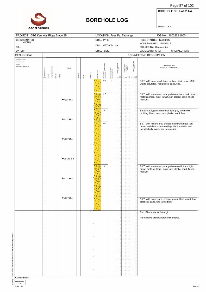
Bore
Log -
24/1
0/2
017 9
:03:2
8 A
M -
Pro
duce
d w
ith C
ore
-GS
by
GeR
oc
v3.1
e
SHEET: 1 OF 1
BOREHOLE No.: Lot 311-A
PROJECT: GTG Kennedy Ridge Stage 2B LOCATION: Pyes Pa, Tauranga JOB No.: 1003262.1000
GEOLOGICAL
WA
TE
R
DE
FE
CT
SP
AC
ING
(cm
)
BOREHOLE LOG
GEOLOGICAL UNIT,
GENERIC NAME,
ORIGIN,
MATERIAL COMPOSITION.
SA
MP
LE
S
ENGINEERING DESCRIPTION
20
60
200
600
2000F
LU
ID L
OS
S (
%)
25
50
75
DE
PT
H (
m)
GR
AP
HIC
LO
G
RL
(m
)
ME
TH
OD
CO
RE
RE
CO
VE
RY
(%
)
TESTS
CA
SIN
G
WE
AT
HE
RIN
GM
OIS
TU
RE
CO
ND
ITIO
N
ST
RE
NG
TH
/DE
NS
ITY
CL
AS
SIF
ICA
TIO
N
SH
EA
R S
TR
EN
GT
H(k
Pa
)
CO
MP
RE
SS
IVE
ST
RE
NG
TH
(MP
a)
1 5 20
50
100
250
10
25
50
100
200
CO-ORDINATES:(NZTM)
R.L.:
DATUM: DRILL FLUID:
DRILL METHOD: HA
DRILL TYPE:
DRILLED BY: Geotechnics
CHECKED: DFBLOGGED BY: SREI
HOLE FINISHED: 12/09/2017
HOLE STARTED: 12/09/2017
Description andAdditional Observations
1
2
>227 kPa
>227 kPa
>227 kPa
207/49 kPa
>227 kPa
>227 kPa
SILT, with trace sand, trace rootlets; dark brown. Stiff,wet to saturated, non plastic; sand, fine.
SILT, with some sand; orange brown, trace dark brownmottling. Hard, moist to wet, non plastic; sand, fine tomedium.
Sandy SILT; grey with minor light grey and brownmottling. Hard, moist, non plastic; sand, fine.
SILT, with minor sand; orange brown with trace lightbrown and dark brown mottling. Hard, moist to wet,low plasticity; sand, fine to medium.
SILT, with some sand; orange brown with trace lightbrown mottling. Hard, moist, non plastic; sand, fine tomedium
SILT, with minor sand; orange brown. Hard, moist, lowplasticity; sand, fine to medium.
End of borehole at 2.0mbgl.
No standing groundwater encountered.
W-S
M-W
M
M-W
M
St
H
Hole Depth2m
COMMENTS:
Scale 1:15 Rev.: A
Page 87 of 102

Bore
Log -
24/1
0/2
017 9
:03:2
8 A
M -
Pro
duce
d w
ith C
ore
-GS
by
GeR
oc
v3.1
e
SHEET: 1 OF 1
BOREHOLE No.: Lot 311-B
PROJECT: GTG Kennedy Ridge Stage 2B LOCATION: Pyes Pa, Tauranga JOB No.: 1003262.1000
GEOLOGICAL
WA
TE
R
DE
FE
CT
SP
AC
ING
(cm
)
BOREHOLE LOG
GEOLOGICAL UNIT,
GENERIC NAME,
ORIGIN,
MATERIAL COMPOSITION.
SA
MP
LE
S
ENGINEERING DESCRIPTION
20
60
200
600
2000F
LU
ID L
OS
S (
%)
25
50
75
DE
PT
H (
m)
GR
AP
HIC
LO
G
RL
(m
)
ME
TH
OD
CO
RE
RE
CO
VE
RY
(%
)
TESTS
CA
SIN
G
WE
AT
HE
RIN
GM
OIS
TU
RE
CO
ND
ITIO
N
ST
RE
NG
TH
/DE
NS
ITY
CL
AS
SIF
ICA
TIO
N
SH
EA
R S
TR
EN
GT
H(k
Pa
)
CO
MP
RE
SS
IVE
ST
RE
NG
TH
(MP
a)
1 5 20
50
100
250
10
25
50
100
200
CO-ORDINATES:(NZTM)
R.L.:
DATUM: DRILL FLUID:
DRILL METHOD: HA
DRILL TYPE:
DRILLED BY: Geotechnics
CHECKED: DFBLOGGED BY: SREI
HOLE FINISHED: 12/09/2017
HOLE STARTED: 12/09/2017
Description andAdditional Observations
1
2
UTP
UTP
UTP
SILT, with trace sand, trace rootlets; dark brownishblack. Stiff, moist to wet, non plastic; sand, fine.
SILT, with some sand; orange brown with minor lightbrown mottling. Hard, moist, non plastic; sand, fine tomedium
SILT, with some clay, minor sand; orange brown withsome light brown, brown and dark brown mottling.Hard, moist to wet, low plasticity; sand, fine tomedium.
End of borehole at 1.0mbgl.
No standing groundwater encountered.
M-W
M
M-W
St
H
Hole Depth1m
COMMENTS:
Scale 1:15 Rev.: A
Page 88 of 102
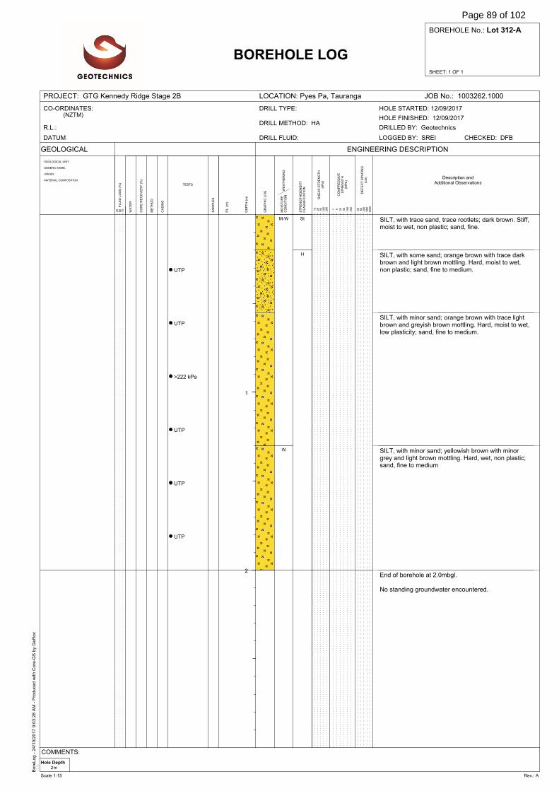
Bore
Log -
24/1
0/2
017 9
:03:2
8 A
M -
Pro
duce
d w
ith C
ore
-GS
by
GeR
oc
v3.1
e
SHEET: 1 OF 1
BOREHOLE No.: Lot 312-A
PROJECT: GTG Kennedy Ridge Stage 2B LOCATION: Pyes Pa, Tauranga JOB No.: 1003262.1000
GEOLOGICAL
WA
TE
R
DE
FE
CT
SP
AC
ING
(cm
)
BOREHOLE LOG
GEOLOGICAL UNIT,
GENERIC NAME,
ORIGIN,
MATERIAL COMPOSITION.
SA
MP
LE
S
ENGINEERING DESCRIPTION
20
60
200
600
2000F
LU
ID L
OS
S (
%)
25
50
75
DE
PT
H (
m)
GR
AP
HIC
LO
G
RL
(m
)
ME
TH
OD
CO
RE
RE
CO
VE
RY
(%
)
TESTS
CA
SIN
G
WE
AT
HE
RIN
GM
OIS
TU
RE
CO
ND
ITIO
N
ST
RE
NG
TH
/DE
NS
ITY
CL
AS
SIF
ICA
TIO
N
SH
EA
R S
TR
EN
GT
H(k
Pa
)
CO
MP
RE
SS
IVE
ST
RE
NG
TH
(MP
a)
1 5 20
50
100
250
10
25
50
100
200
CO-ORDINATES:(NZTM)
R.L.:
DATUM: DRILL FLUID:
DRILL METHOD: HA
DRILL TYPE:
DRILLED BY: Geotechnics
CHECKED: DFBLOGGED BY: SREI
HOLE FINISHED: 12/09/2017
HOLE STARTED: 12/09/2017
Description andAdditional Observations
1
2
UTP
UTP
>222 kPa
UTP
UTP
UTP
SILT, with trace sand, trace rootlets; dark brown. Stiff,moist to wet, non plastic; sand, fine.
SILT, with some sand; orange brown with trace darkbrown and light brown mottling. Hard, moist to wet,non plastic; sand, fine to medium.
SILT, with minor sand; orange brown with trace lightbrown and greyish brown mottling. Hard, moist to wet,low plasticity; sand, fine to medium.
SILT, with minor sand; yellowish brown with minorgrey and light brown mottling. Hard, wet, non plastic;sand, fine to medium
End of borehole at 2.0mbgl.
No standing groundwater encountered.
M-W
W
St
H
Hole Depth2m
COMMENTS:
Scale 1:15 Rev.: A
Page 89 of 102
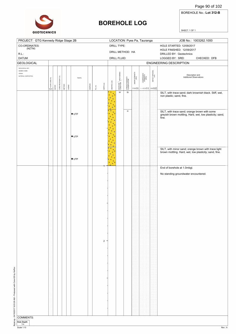
Bore
Log -
24/1
0/2
017 9
:03:2
8 A
M -
Pro
duce
d w
ith C
ore
-GS
by
GeR
oc
v3.1
e
SHEET: 1 OF 1
BOREHOLE No.: Lot 312-B
PROJECT: GTG Kennedy Ridge Stage 2B LOCATION: Pyes Pa, Tauranga JOB No.: 1003262.1000
GEOLOGICAL
WA
TE
R
DE
FE
CT
SP
AC
ING
(cm
)
BOREHOLE LOG
GEOLOGICAL UNIT,
GENERIC NAME,
ORIGIN,
MATERIAL COMPOSITION.
SA
MP
LE
S
ENGINEERING DESCRIPTION
20
60
200
600
2000F
LU
ID L
OS
S (
%)
25
50
75
DE
PT
H (
m)
GR
AP
HIC
LO
G
RL
(m
)
ME
TH
OD
CO
RE
RE
CO
VE
RY
(%
)
TESTS
CA
SIN
G
WE
AT
HE
RIN
GM
OIS
TU
RE
CO
ND
ITIO
N
ST
RE
NG
TH
/DE
NS
ITY
CL
AS
SIF
ICA
TIO
N
SH
EA
R S
TR
EN
GT
H(k
Pa
)
CO
MP
RE
SS
IVE
ST
RE
NG
TH
(MP
a)
1 5 20
50
100
250
10
25
50
100
200
CO-ORDINATES:(NZTM)
R.L.:
DATUM: DRILL FLUID:
DRILL METHOD: HA
DRILL TYPE:
DRILLED BY: Geotechnics
CHECKED: DFBLOGGED BY: SREI
HOLE FINISHED: 12/09/2017
HOLE STARTED: 12/09/2017
Description andAdditional Observations
1
2
UTP
UTP
UTP
SILT, with trace sand; dark brownish black. Stiff, wet,non plastic; sand, fine.
SILT, with trace sand; orange brown with somegreyish brown mottling. Hard, wet, low plasticity; sand,fine.
SILT, with minor sand; orange brown with trace lightbrown mottling. Hard, wet, low plasticity; sand, fine.
End of borehole at 1.0mbgl.
No standing groundwater encountered.
W St
H
Hole Depth1m
COMMENTS:
Scale 1:15 Rev.: A
Page 90 of 102
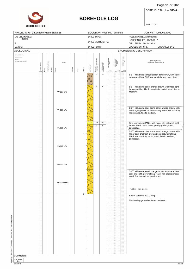
Bore
Log -
24/1
0/2
017 9
:03:2
8 A
M -
Pro
duce
d w
ith C
ore
-GS
by
GeR
oc
v3.1
e
SHEET: 1 OF 1
BOREHOLE No.: Lot 313-A
PROJECT: GTG Kennedy Ridge Stage 2B LOCATION: Pyes Pa, Tauranga JOB No.: 1003262.1000
GEOLOGICAL
WA
TE
R
DE
FE
CT
SP
AC
ING
(cm
)
BOREHOLE LOG
GEOLOGICAL UNIT,
GENERIC NAME,
ORIGIN,
MATERIAL COMPOSITION.
SA
MP
LE
S
ENGINEERING DESCRIPTION
20
60
200
600
2000F
LU
ID L
OS
S (
%)
25
50
75
DE
PT
H (
m)
GR
AP
HIC
LO
G
RL
(m
)
ME
TH
OD
CO
RE
RE
CO
VE
RY
(%
)
TESTS
CA
SIN
G
WE
AT
HE
RIN
GM
OIS
TU
RE
CO
ND
ITIO
N
ST
RE
NG
TH
/DE
NS
ITY
CL
AS
SIF
ICA
TIO
N
SH
EA
R S
TR
EN
GT
H(k
Pa
)
CO
MP
RE
SS
IVE
ST
RE
NG
TH
(MP
a)
1 5 20
50
100
250
10
25
50
100
200
CO-ORDINATES:(NZTM)
R.L.:
DATUM: DRILL FLUID:
DRILL METHOD: HA
DRILL TYPE:
DRILLED BY: Geotechnics
CHECKED: DFBLOGGED BY: SREI
HOLE FINISHED: 20/09/2017
HOLE STARTED: 20/09/2017
Description andAdditional Observations
1
2
>227 kPa
>227 kPa
>227 kPa
>227 kPa
>227 kPa
211/68 kPa
SILT, with trace sand; blackish dark brown, with traceorange mottling. Stiff; low plasticity; wet; sand, fine.
SILT, with some sand; orange brown, with trace lightbrown mottling. Hard; non-plastic; moist; sand, fine tomedium.
SILT, with some clay, some sand; orange brown, withminor light greyish brown mottling. Hard; low plasticity;moist; sand, fine to medium.
Fine to medium SAND, with minor silt; yellowish lightbrown. Hard; dry to moist; poorly graded; sand,pumiceous.
SILT, with some clay, some sand; orange brown, withminor dark greenish grey and light brown mottling.Hard; low plasticity; moist; sand, fine to medium,pumiceous.
SILT, with some sand; orange brown, with trace darkgrey and light grey mottling. Hard; non-plastic; moist;sand, fine to medium, pumiceous.
End of borehole at 2.0 mbgl.
No standing groundwater encountered.
1.60m: - non-plastic
W
M
D-M
M
St
H
MD
H
Hole Depth2m
COMMENTS:
Scale 1:15 Rev.: A
Page 91 of 102

Bore
Log -
24/1
0/2
017 9
:03:2
8 A
M -
Pro
duce
d w
ith C
ore
-GS
by
GeR
oc
v3.1
e
SHEET: 1 OF 1
BOREHOLE No.: Lot 313-B
PROJECT: GTG Kennedy Ridge Stage 2B LOCATION: Pyes Pa, Tauranga JOB No.: 1003262.1000
GEOLOGICAL
WA
TE
R
DE
FE
CT
SP
AC
ING
(cm
)
BOREHOLE LOG
GEOLOGICAL UNIT,
GENERIC NAME,
ORIGIN,
MATERIAL COMPOSITION.
SA
MP
LE
S
ENGINEERING DESCRIPTION
20
60
200
600
2000F
LU
ID L
OS
S (
%)
25
50
75
DE
PT
H (
m)
GR
AP
HIC
LO
G
RL
(m
)
ME
TH
OD
CO
RE
RE
CO
VE
RY
(%
)
TESTS
CA
SIN
G
WE
AT
HE
RIN
GM
OIS
TU
RE
CO
ND
ITIO
N
ST
RE
NG
TH
/DE
NS
ITY
CL
AS
SIF
ICA
TIO
N
SH
EA
R S
TR
EN
GT
H(k
Pa
)
CO
MP
RE
SS
IVE
ST
RE
NG
TH
(MP
a)
1 5 20
50
100
250
10
25
50
100
200
CO-ORDINATES:(NZTM)
R.L.:
DATUM: DRILL FLUID:
DRILL METHOD: HA
DRILL TYPE:
DRILLED BY: Geotechnics
CHECKED: DFBLOGGED BY: SREI
HOLE FINISHED: 20/09/2017
HOLE STARTED: 20/09/2017
Description andAdditional Observations
1
2
>227 kPa
UTP
>227 kPa
SILT, with trace sand, trace rootlets; dark brownishblack. Stiff; low plasticity; wet; sand, fine.
SILT, with minor sand; orange brown, with trace lightbrown mottling. Hard; non-plastic; moist; sand, fine tomedium.
SILT, with some sand, some clay; orange brown, withtrace light brown mottling. Hard; low plasticity; moist towet; sand, fine to medium.
SILT, with some sand; orange brown, with trace lightbrown mottling. Hard; non-plastic; moist; sand, fine tomedium.
SILT, with some sand, some clay; orange brown, withdark brown mottling. Hard; low plasticity; moist to wet;sand, fine to medium.
End of borehole at 1.0 mbgl.
No standing groundwater encountered.
0.60m: - some sand
W
M
M-W
M
M-W
St
H
Hole Depth1m
COMMENTS:
Scale 1:15 Rev.: A
Page 92 of 102
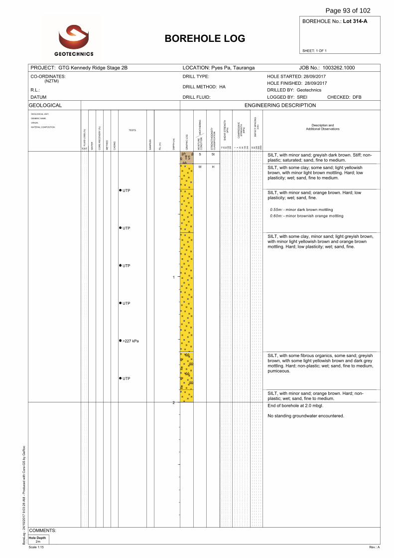
Bore
Log -
24/1
0/2
017 9
:03:2
8 A
M -
Pro
duce
d w
ith C
ore
-GS
by
GeR
oc
v3.1
e
SHEET: 1 OF 1
BOREHOLE No.: Lot 314-A
PROJECT: GTG Kennedy Ridge Stage 2B LOCATION: Pyes Pa, Tauranga JOB No.: 1003262.1000
GEOLOGICAL
WA
TE
R
DE
FE
CT
SP
AC
ING
(cm
)
BOREHOLE LOG
GEOLOGICAL UNIT,
GENERIC NAME,
ORIGIN,
MATERIAL COMPOSITION.
SA
MP
LE
S
ENGINEERING DESCRIPTION
20
60
200
600
2000F
LU
ID L
OS
S (
%)
25
50
75
DE
PT
H (
m)
GR
AP
HIC
LO
G
RL
(m
)
ME
TH
OD
CO
RE
RE
CO
VE
RY
(%
)
TESTS
CA
SIN
G
WE
AT
HE
RIN
GM
OIS
TU
RE
CO
ND
ITIO
N
ST
RE
NG
TH
/DE
NS
ITY
CL
AS
SIF
ICA
TIO
N
SH
EA
R S
TR
EN
GT
H(k
Pa
)
CO
MP
RE
SS
IVE
ST
RE
NG
TH
(MP
a)
1 5 20
50
100
250
10
25
50
100
200
CO-ORDINATES:(NZTM)
R.L.:
DATUM: DRILL FLUID:
DRILL METHOD: HA
DRILL TYPE:
DRILLED BY: Geotechnics
CHECKED: DFBLOGGED BY: SREI
HOLE FINISHED: 28/09/2017
HOLE STARTED: 28/09/2017
Description andAdditional Observations
1
2
UTP
UTP
UTP
UTP
>227 kPa
UTP
SILT, with minor sand; greyish dark brown. Stiff; non-plastic; saturated; sand, fine to medium.
SILT, with some clay; some sand; light yellowishbrown, with minor light brown mottling. Hard; lowplasticity; wet; sand, fine to medium.
SILT, with minor sand; orange brown. Hard; lowplasticity; wet; sand, fine.
SILT, with some clay, minor sand; light greyish brown,with minor light yellowish brown and orange brownmottling. Hard; low plasticity; wet; sand, fine.
SILT, with some fibrous organics, some sand; greyishbrown, with some light yellowish brown and dark greymottling. Hard; non-plastic; wet; sand, fine to medium,pumiceous.
SILT, with minor sand; orange brown. Hard; non-plastic; wet; sand, fine to medium.
End of borehole at 2.0 mbgl.
No standing groundwater encountered.
0.55m: - minor dark brown mottling
0.60m: - minor brownish orange mottling
S
W
St
H
Hole Depth2m
COMMENTS:
Scale 1:15 Rev.: A
Page 93 of 102
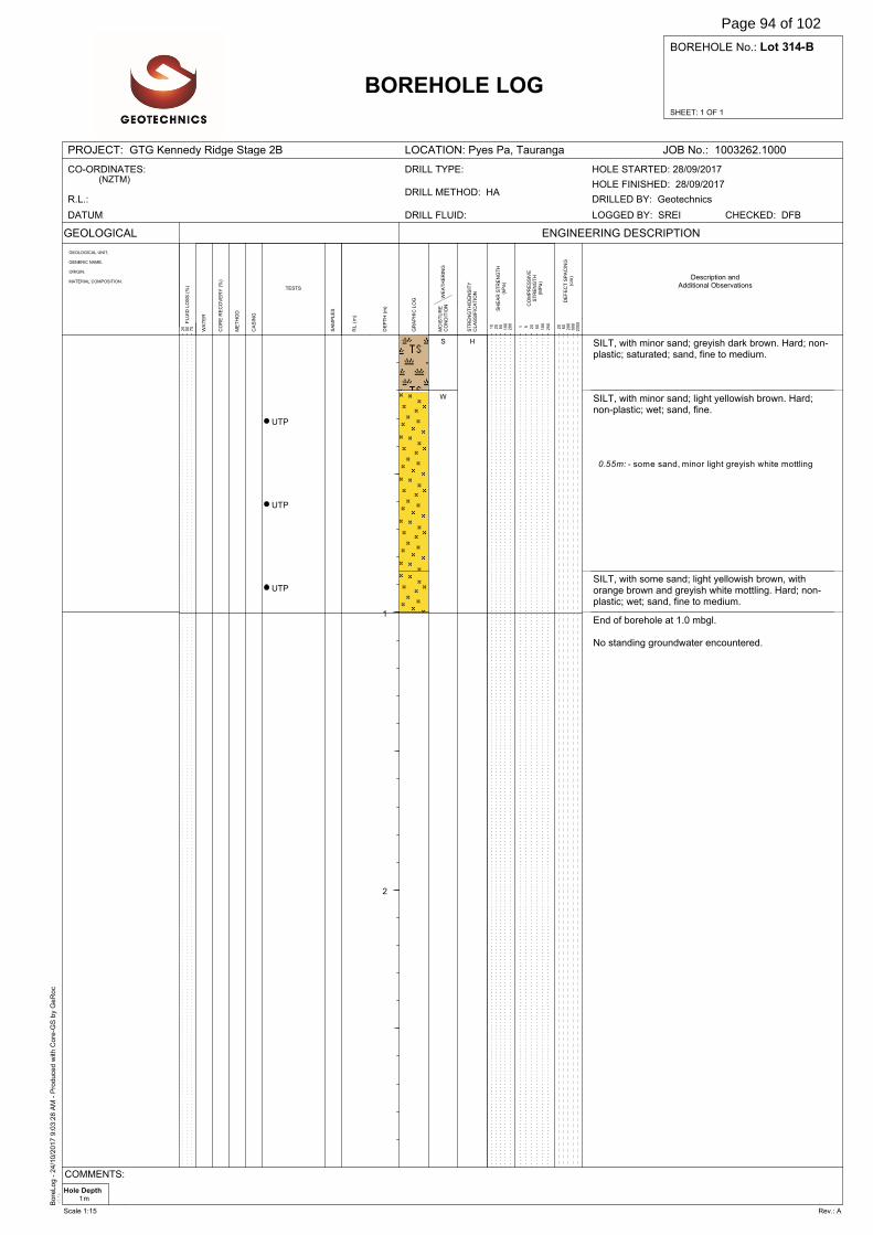
Bore
Log -
24/1
0/2
017 9
:03:2
8 A
M -
Pro
duce
d w
ith C
ore
-GS
by
GeR
oc
v3.1
e
SHEET: 1 OF 1
BOREHOLE No.: Lot 314-B
PROJECT: GTG Kennedy Ridge Stage 2B LOCATION: Pyes Pa, Tauranga JOB No.: 1003262.1000
GEOLOGICAL
WA
TE
R
DE
FE
CT
SP
AC
ING
(cm
)
BOREHOLE LOG
GEOLOGICAL UNIT,
GENERIC NAME,
ORIGIN,
MATERIAL COMPOSITION.
SA
MP
LE
S
ENGINEERING DESCRIPTION
20
60
200
600
2000F
LU
ID L
OS
S (
%)
25
50
75
DE
PT
H (
m)
GR
AP
HIC
LO
G
RL
(m
)
ME
TH
OD
CO
RE
RE
CO
VE
RY
(%
)
TESTS
CA
SIN
G
WE
AT
HE
RIN
GM
OIS
TU
RE
CO
ND
ITIO
N
ST
RE
NG
TH
/DE
NS
ITY
CL
AS
SIF
ICA
TIO
N
SH
EA
R S
TR
EN
GT
H(k
Pa
)
CO
MP
RE
SS
IVE
ST
RE
NG
TH
(MP
a)
1 5 20
50
100
250
10
25
50
100
200
CO-ORDINATES:(NZTM)
R.L.:
DATUM: DRILL FLUID:
DRILL METHOD: HA
DRILL TYPE:
DRILLED BY: Geotechnics
CHECKED: DFBLOGGED BY: SREI
HOLE FINISHED: 28/09/2017
HOLE STARTED: 28/09/2017
Description andAdditional Observations
1
2
UTP
UTP
UTP
SILT, with minor sand; greyish dark brown. Hard; non-plastic; saturated; sand, fine to medium.
SILT, with minor sand; light yellowish brown. Hard;non-plastic; wet; sand, fine.
SILT, with some sand; light yellowish brown, withorange brown and greyish white mottling. Hard; non-plastic; wet; sand, fine to medium.
End of borehole at 1.0 mbgl.
No standing groundwater encountered.
0.55m: - some sand, minor light greyish white mottling
S
W
H
Hole Depth1m
COMMENTS:
Scale 1:15 Rev.: A
Page 94 of 102
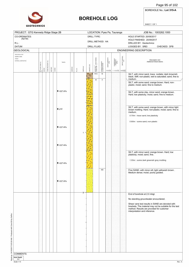
Bore
Log -
24/1
0/2
017 9
:03:2
8 A
M -
Pro
duce
d w
ith C
ore
-GS
by
GeR
oc
v3.1
e
SHEET: 1 OF 1
BOREHOLE No.: Lot 315-A
PROJECT: GTG Kennedy Ridge Stage 2B LOCATION: Pyes Pa, Tauranga JOB No.: 1003262.1000
GEOLOGICAL
WA
TE
R
DE
FE
CT
SP
AC
ING
(cm
)
BOREHOLE LOG
GEOLOGICAL UNIT,
GENERIC NAME,
ORIGIN,
MATERIAL COMPOSITION.
SA
MP
LE
S
ENGINEERING DESCRIPTION
20
60
200
600
2000F
LU
ID L
OS
S (
%)
25
50
75
DE
PT
H (
m)
GR
AP
HIC
LO
G
RL
(m
)
ME
TH
OD
CO
RE
RE
CO
VE
RY
(%
)
TESTS
CA
SIN
G
WE
AT
HE
RIN
GM
OIS
TU
RE
CO
ND
ITIO
N
ST
RE
NG
TH
/DE
NS
ITY
CL
AS
SIF
ICA
TIO
N
SH
EA
R S
TR
EN
GT
H(k
Pa
)
CO
MP
RE
SS
IVE
ST
RE
NG
TH
(MP
a)
1 5 20
50
100
250
10
25
50
100
200
CO-ORDINATES:(NZTM)
R.L.:
DATUM: DRILL FLUID:
DRILL METHOD: HA
DRILL TYPE:
DRILLED BY: Geotechnics
CHECKED: DFBLOGGED BY: SREI
HOLE FINISHED: 20/09/2017
HOLE STARTED: 20/09/2017
Description andAdditional Observations
1
2
>227 kPa
UTP
>227 kPa
>227 kPa
>227 kPa
>227 kPa
SILT, with minor sand, trace rootlets; dark brownishblack. Stiff; non-plastic; wet to saturated; sand, fine tomedium.
SILT, with some sand; orange brown. Hard; non-plastic; moist; sand, fine to medium.
SILT, with some clay, minor sand; orange brown.Hard; low plasticity; moist; sand, fine to medium.
SILT, with some sand; orange brown, with minor lightbrown mottling. Hard; non-plastic; moist; sand, fine tomedium.
SILT, with minor sand; orange brown. Hard; lowplasticity; moist; sand, fine.
Fine SAND, with minor silt; light yellowish brown.Medium dense; moist; poorly graded.
End of borehole at 2.0 mbgl.
No standing groundwater encountered.
Shear vane test results in SAND are denoted withbrackets. The material may not be suitable for the testmethod. Results are provided for customerinterpretation and inference.
0.70m: - trace sand, low plasticity
0.80m: - some sand, non-plastic
1.55m: - some dark greenish grey mottling
W-S
M
St
H
MD
Hole Depth2m
COMMENTS:
Scale 1:15 Rev.: A
Page 95 of 102
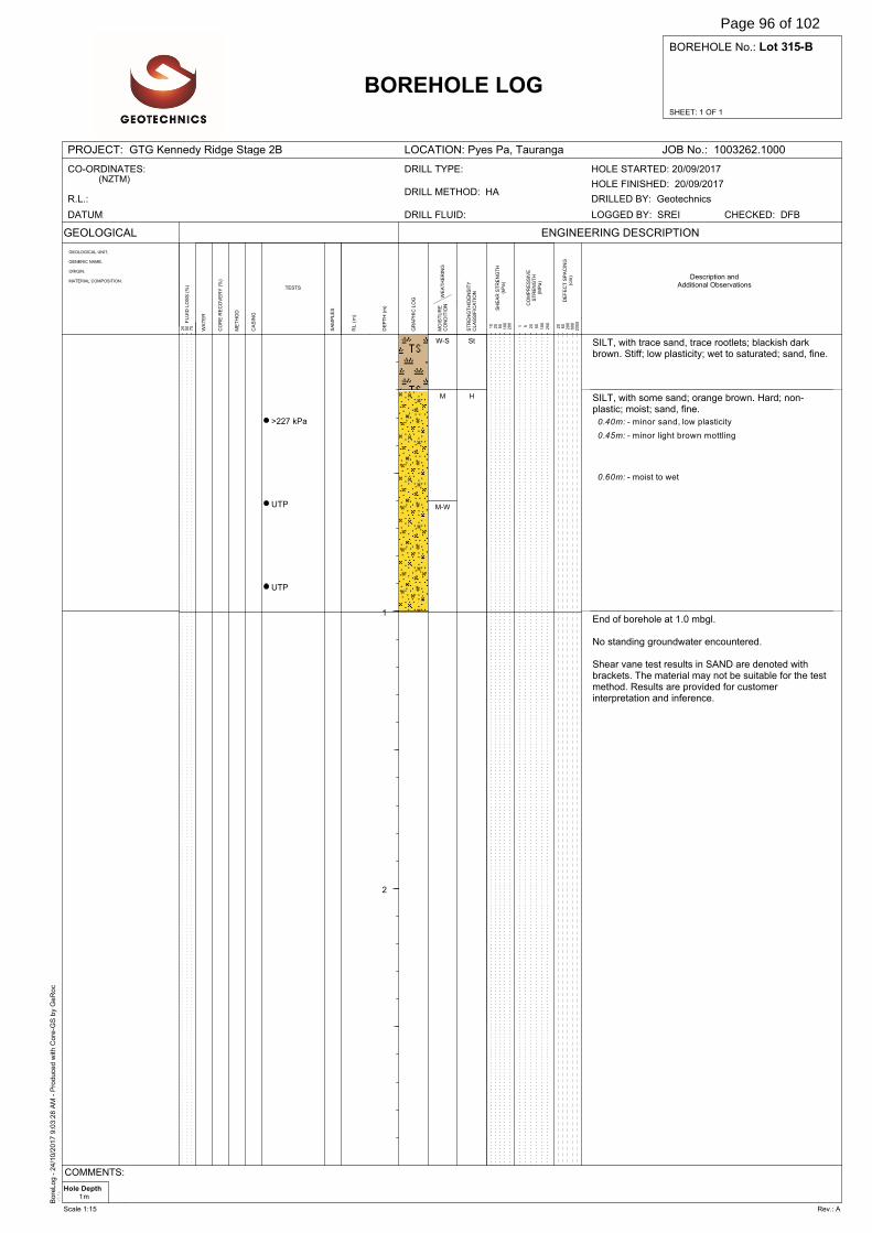
Bore
Log -
24/1
0/2
017 9
:03:2
8 A
M -
Pro
duce
d w
ith C
ore
-GS
by
GeR
oc
v3.1
e
SHEET: 1 OF 1
BOREHOLE No.: Lot 315-B
PROJECT: GTG Kennedy Ridge Stage 2B LOCATION: Pyes Pa, Tauranga JOB No.: 1003262.1000
GEOLOGICAL
WA
TE
R
DE
FE
CT
SP
AC
ING
(cm
)
BOREHOLE LOG
GEOLOGICAL UNIT,
GENERIC NAME,
ORIGIN,
MATERIAL COMPOSITION.
SA
MP
LE
S
ENGINEERING DESCRIPTION
20
60
200
600
2000F
LU
ID L
OS
S (
%)
25
50
75
DE
PT
H (
m)
GR
AP
HIC
LO
G
RL
(m
)
ME
TH
OD
CO
RE
RE
CO
VE
RY
(%
)
TESTS
CA
SIN
G
WE
AT
HE
RIN
GM
OIS
TU
RE
CO
ND
ITIO
N
ST
RE
NG
TH
/DE
NS
ITY
CL
AS
SIF
ICA
TIO
N
SH
EA
R S
TR
EN
GT
H(k
Pa
)
CO
MP
RE
SS
IVE
ST
RE
NG
TH
(MP
a)
1 5 20
50
100
250
10
25
50
100
200
CO-ORDINATES:(NZTM)
R.L.:
DATUM: DRILL FLUID:
DRILL METHOD: HA
DRILL TYPE:
DRILLED BY: Geotechnics
CHECKED: DFBLOGGED BY: SREI
HOLE FINISHED: 20/09/2017
HOLE STARTED: 20/09/2017
Description andAdditional Observations
1
2
>227 kPa
UTP
UTP
SILT, with trace sand, trace rootlets; blackish darkbrown. Stiff; low plasticity; wet to saturated; sand, fine.
SILT, with some sand; orange brown. Hard; non-plastic; moist; sand, fine.
End of borehole at 1.0 mbgl.
No standing groundwater encountered.
Shear vane test results in SAND are denoted withbrackets. The material may not be suitable for the testmethod. Results are provided for customerinterpretation and inference.
0.40m: - minor sand, low plasticity
0.45m: - minor light brown mottling
0.60m: - moist to wet
W-S
M
M-W
St
H
Hole Depth1m
COMMENTS:
Scale 1:15 Rev.: A
Page 96 of 102
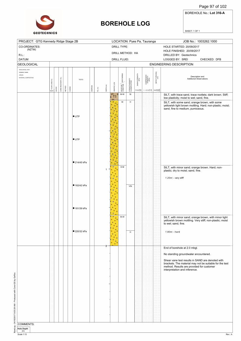
Bore
Log -
24/1
0/2
017 9
:03:2
8 A
M -
Pro
duce
d w
ith C
ore
-GS
by
GeR
oc
v3.1
e
SHEET: 1 OF 1
BOREHOLE No.: Lot 316-A
PROJECT: GTG Kennedy Ridge Stage 2B LOCATION: Pyes Pa, Tauranga JOB No.: 1003262.1000
GEOLOGICAL
WA
TE
R
DE
FE
CT
SP
AC
ING
(cm
)
BOREHOLE LOG
GEOLOGICAL UNIT,
GENERIC NAME,
ORIGIN,
MATERIAL COMPOSITION.
SA
MP
LE
S
ENGINEERING DESCRIPTION
20
60
200
600
2000F
LU
ID L
OS
S (
%)
25
50
75
DE
PT
H (
m)
GR
AP
HIC
LO
G
RL
(m
)
ME
TH
OD
CO
RE
RE
CO
VE
RY
(%
)
TESTS
CA
SIN
G
WE
AT
HE
RIN
GM
OIS
TU
RE
CO
ND
ITIO
N
ST
RE
NG
TH
/DE
NS
ITY
CL
AS
SIF
ICA
TIO
N
SH
EA
R S
TR
EN
GT
H(k
Pa
)
CO
MP
RE
SS
IVE
ST
RE
NG
TH
(MP
a)
1 5 20
50
100
250
10
25
50
100
200
CO-ORDINATES:(NZTM)
R.L.:
DATUM: DRILL FLUID:
DRILL METHOD: HA
DRILL TYPE:
DRILLED BY: Geotechnics
CHECKED: DFBLOGGED BY: SREI
HOLE FINISHED: 20/09/2017
HOLE STARTED: 20/09/2017
Description andAdditional Observations
1
2
UTP
UTP
214/45 kPa
162/42 kPa
181/39 kPa
220/32 kPa
SILT, with trace sand, trace rootlets; dark brown. Stiff;low plasticity; moist to wet; sand, fine.
SILT, with some sand; orange brown, with someyellowish light brown mottling. Hard; non-plastic; moist;sand, fine to medium, pumiceous.
SILT, with minor sand; orange brown. Hard; non-plastic; dry to moist; sand, fine.
SILT, with minor sand; orange brown, with minor lightyellowish brown mottling. Very stiff; non-plastic; moistto wet; sand, fine.
End of borehole at 2.0 mbgl.
No standing groundwater encountered.
Shear vane test results in SAND are denoted withbrackets. The material may not be suitable for the testmethod. Results are provided for customerinterpretation and inference.
1.20m: - very stiff
1.80m: - hard
M-W
M
D-M
M-W
St
H
VSt
H
Hole Depth2m
COMMENTS:
Scale 1:15 Rev.: A
Page 97 of 102
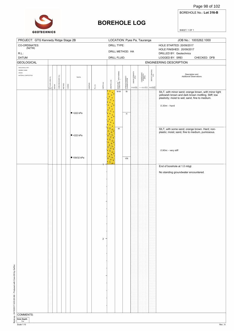
Bore
Log -
24/1
0/2
017 9
:03:2
8 A
M -
Pro
duce
d w
ith C
ore
-GS
by
GeR
oc
v3.1
e
SHEET: 1 OF 1
BOREHOLE No.: Lot 316-B
PROJECT: GTG Kennedy Ridge Stage 2B LOCATION: Pyes Pa, Tauranga JOB No.: 1003262.1000
GEOLOGICAL
WA
TE
R
DE
FE
CT
SP
AC
ING
(cm
)
BOREHOLE LOG
GEOLOGICAL UNIT,
GENERIC NAME,
ORIGIN,
MATERIAL COMPOSITION.
SA
MP
LE
S
ENGINEERING DESCRIPTION
20
60
200
600
2000F
LU
ID L
OS
S (
%)
25
50
75
DE
PT
H (
m)
GR
AP
HIC
LO
G
RL
(m
)
ME
TH
OD
CO
RE
RE
CO
VE
RY
(%
)
TESTS
CA
SIN
G
WE
AT
HE
RIN
GM
OIS
TU
RE
CO
ND
ITIO
N
ST
RE
NG
TH
/DE
NS
ITY
CL
AS
SIF
ICA
TIO
N
SH
EA
R S
TR
EN
GT
H(k
Pa
)
CO
MP
RE
SS
IVE
ST
RE
NG
TH
(MP
a)
1 5 20
50
100
250
10
25
50
100
200
CO-ORDINATES:(NZTM)
R.L.:
DATUM: DRILL FLUID:
DRILL METHOD: HA
DRILL TYPE:
DRILLED BY: Geotechnics
CHECKED: DFBLOGGED BY: SREI
HOLE FINISHED: 20/09/2017
HOLE STARTED: 20/09/2017
Description andAdditional Observations
1
2
>222 kPa
>222 kPa
159/32 kPa
SILT, with minor sand; orange brown, with minor lightyellowish brown and dark brown mottling. Stiff; lowplasticity; moist to wet; sand, fine to medium.
SILT, with some sand; orange brown. Hard; non-plastic; moist; sand, fine to medium, pumiceous.
End of borehole at 1.0 mbgl.
No standing groundwater encountered.
0.30m: - hard
0.90m: - very stiff
M-W
M
St
H
VSt
Hole Depth1m
COMMENTS:
Scale 1:15 Rev.: A
Page 98 of 102
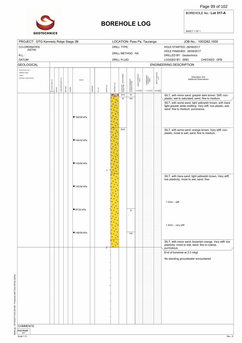
Bore
Log -
24/1
0/2
017 9
:03:2
8 A
M -
Pro
duce
d w
ith C
ore
-GS
by
GeR
oc
v3.1
e
SHEET: 1 OF 1
BOREHOLE No.: Lot 317-A
PROJECT: GTG Kennedy Ridge Stage 2B LOCATION: Pyes Pa, Tauranga JOB No.: 1003262.1000
GEOLOGICAL
WA
TE
R
DE
FE
CT
SP
AC
ING
(cm
)
BOREHOLE LOG
GEOLOGICAL UNIT,
GENERIC NAME,
ORIGIN,
MATERIAL COMPOSITION.
SA
MP
LE
S
ENGINEERING DESCRIPTION
20
60
200
600
2000F
LU
ID L
OS
S (
%)
25
50
75
DE
PT
H (
m)
GR
AP
HIC
LO
G
RL
(m
)
ME
TH
OD
CO
RE
RE
CO
VE
RY
(%
)
TESTS
CA
SIN
G
WE
AT
HE
RIN
GM
OIS
TU
RE
CO
ND
ITIO
N
ST
RE
NG
TH
/DE
NS
ITY
CL
AS
SIF
ICA
TIO
N
SH
EA
R S
TR
EN
GT
H(k
Pa
)
CO
MP
RE
SS
IVE
ST
RE
NG
TH
(MP
a)
1 5 20
50
100
250
10
25
50
100
200
CO-ORDINATES:(NZTM)
R.L.:
DATUM: DRILL FLUID:
DRILL METHOD: HA
DRILL TYPE:
DRILLED BY: Geotechnics
CHECKED: DFBLOGGED BY: SREI
HOLE FINISHED: 28/09/2017
HOLE STARTED: 28/09/2017
Description andAdditional Observations
1
2
162/26 kPa
194/32 kPa
143/26 kPa
143/36 kPa
97/32 kPa
146/36 kPa
SILT, with minor sand; greyish dark brown. Stiff; non-plastic; wet to saturated; sand, fine to medium.
SILT, with some sand; light yellowish brown, with tracelight greyish white mottling. Very stiff; non-plastic; wet;sand, fine to medium, pumiceous.
SILT, with some sand; orange brown. Very stiff; non-plastic; moist to wet; sand, fine to medium.
SILT, with trace sand; light yellowish brown. Very stiff;low plasticity; moist to wet; sand, fine.
SILT, with minor sand; brownish orange. Very stiff; lowplasticity; moist to wet; sand, fine to coarse,pumiceous.
End of borehole at 2.0 mbgl.
No standing groundwater encountered.
1.50m: - stiff
1.80m: - very stiff
W-S
W
M-W
St
VSt
St
VSt
Hole Depth2m
COMMENTS:
Scale 1:15 Rev.: A
Page 99 of 102

Bore
Log -
24/1
0/2
017 9
:03:2
8 A
M -
Pro
duce
d w
ith C
ore
-GS
by
GeR
oc
v3.1
e
SHEET: 1 OF 1
BOREHOLE No.: Lot 317-B
PROJECT: GTG Kennedy Ridge Stage 2B LOCATION: Pyes Pa, Tauranga JOB No.: 1003262.1000
GEOLOGICAL
WA
TE
R
DE
FE
CT
SP
AC
ING
(cm
)
BOREHOLE LOG
GEOLOGICAL UNIT,
GENERIC NAME,
ORIGIN,
MATERIAL COMPOSITION.
SA
MP
LE
S
ENGINEERING DESCRIPTION
20
60
200
600
2000F
LU
ID L
OS
S (
%)
25
50
75
DE
PT
H (
m)
GR
AP
HIC
LO
G
RL
(m
)
ME
TH
OD
CO
RE
RE
CO
VE
RY
(%
)
TESTS
CA
SIN
G
WE
AT
HE
RIN
GM
OIS
TU
RE
CO
ND
ITIO
N
ST
RE
NG
TH
/DE
NS
ITY
CL
AS
SIF
ICA
TIO
N
SH
EA
R S
TR
EN
GT
H(k
Pa
)
CO
MP
RE
SS
IVE
ST
RE
NG
TH
(MP
a)
1 5 20
50
100
250
10
25
50
100
200
CO-ORDINATES:(NZTM)
R.L.:
DATUM: DRILL FLUID:
DRILL METHOD: HA
DRILL TYPE:
DRILLED BY: Geotechnics
CHECKED: DFBLOGGED BY: SREI
HOLE FINISHED: 29/09/2017
HOLE STARTED: 29/09/2017
Description andAdditional Observations
1
2
114/19 kPa
83/19 kPa
79/16 kPa
SILT, with minor sand, trace fibrous organics; greyishdark brown. Stiff; non-plastic; moist; sand, fine tomedium.
SILT, with trace sand; yellowish brown. Very stiff; lowplasticity; moist; sand, fine.
SILT, with trace sand; yellowish brown. Stiff; lowplasticity; wet; sand, fine.
End of borehole at 1.0 mbgl.
No standing groundwater encountered.
0.60m: - stiff
M
W
St
VSt
St
Hole Depth1m
COMMENTS:
Scale 1:15 Rev.: A
Page 100 of 102


Aurecon New Zealand Limited
Ground Level 247 Cameron Road Tauranga 3110
PO Box 2292 Tauranga 3140 New Zealand
T F E W
+64 7 578 6183 +64 7 578 6143 [email protected] aurecongroup.com
Aurecon offices are located in: Angola, Australia, Botswana, China, Ghana, Hong Kong, Indonesia, Kenya, Lesotho, Macau, Mozambique, Namibia, New Zealand, Nigeria, Philippines, Qatar, Singapore, South Africa, Swaziland, Tanzania, Thailand, Uganda, United Arab Emirates, Vietnam.