michael alderman portfolio
TRANSCRIPT

LINKING NEIGHBOURHOODS
Public Building Axis
By connecting different housing areas and spaces through a strong path system, the design hopes to integrate a large student population with an old agricultural site, while retaining its existing industrial charm. The site’s close proximity to the city centre and nearby University facilities offers potential as a new student accommodation zone.In the city of Groningen approximately 50% of all trips within the city are made by bi-cycle, so easy access to bike lanes and bike parking are essential in the urban scene.
Barriers to pedestrian movement have isolated the site. Opportunities to repair these connections include a pedestrian bridge over the canal (which is currently planned), a path under the major highway on the east and a link crossing the railway which leads to a large recreational park (Stadpark) to the south. The site’s accessiblity to its surroundings is seen as a vital step in bringing the Sugar Fac-tory to life.
Reconnect Isolated Site Vision The ‘Flowing Path’ Neighbourhoods
The shape of the path has been infl uenced by the organic forms of the Rhine-Meuse-Scheldt Delta, which runs through Belgium and the Netherlands. The fl owing path turns and weaves, like a delta, changing spaces and landscape as it meanders over the site. Much like a delta carries and deposits sediment from upstream, the path carries pedestrian movement and provides stopping points and open squares besides its primary transitional function. This allows people to engage with the space beside the path, whether it is public buildings, recrea-tional areas or existing traces of the factory site. New designated open spaces will also allow for opportunities to explore beyond this main transitional path. Materiality is an important tool in establishing boundaries between the primary pedestrian path and these intermittent resting points.
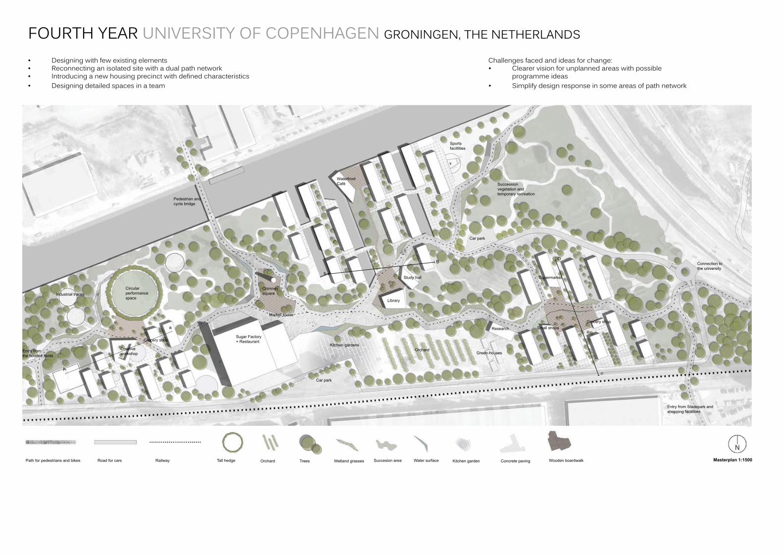
Three condensed neighbourhoods have been established in the design, each with a defi ning character related to its context. To the west, new built form hooks onto the existing industrial traces of the circular silo footprints. This form has been emphasized with the creation of a circular performance space lined by trees. Along the waterfront a new set of buildings and spaces have been set onto a series of canals. The changing heights of the paths, water level and bridg-ing paths provide an engaging experience with built form. The eastern neigh-bourhood, inspired by existing vegetation, is seen as a green environment where the built form is closely connected to dense vegetation and has an easy access to greenhouses, orchards and kitchen gardens.
Three Neighbourhoods
Remnantsdistrict
Water front neighborhood
Green living
Entry Points and Connections
Access to shopping and restaurants
Connection to Groningen city center
Connection to university
Connection to Stadpark
Connection to shopping
Connection to wetland fi elds
Succesionvegetation
Path for pedestrians and bikes Road for cars Railway Tall hedge Orchard Trees Wetland grasses Succesion area Water surface Kitchen garden Concrete paving Wooden boardwalk Masterplan 1:1500
C
B
b
cA
a
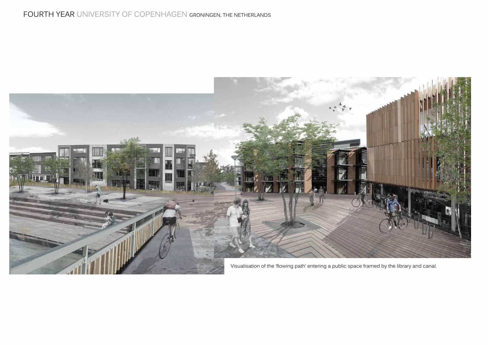
Visualisation of the ‘fl owing path’ entering a public space framed by the library and canal.
Group 10: By Michael Alderman, Amra Ljubijankic , Sif Peiter Lund , Signe Lilleskov Neilson
Library
Research
Green-houses
Entry from Stadspark and shopping facitlities
Connection to the university
Biking and pedestrian connection to the city centre
Car park
Car park
Supermarket
Grocery shopSmall shops
Orchard
Successionvegetation and temporary recreation
Sportsfacitlities
Kitchen gardens
Study hall
Waterfront Café
Chimneysquare
Sugar Factory + Restaurant
Market space
Creativeworkshop
Grocery shop
Circularperformancespace
Pedestrian and cycle bridge
Entry from the fl ooded fi elds
Industrial traces
FOURTH YEAR UNIVERSITY OF COPENHAGEN GRONINGEN, THE NETHERLANDS
• Designingwithfewexistingelements• Reconnectinganisolatedsitewithadualpathnetwork• Introducinganewhousingprecinctwithdefinedcharacteristics• Designingdetailedspacesinateam
Challengesfacedandideasforchange:• Clearervisionforunplannedareaswithpossible programmeideas• Simplifydesignresponseinsomeareasofpathnetwork
FOURTH YEAR UNIVERSITY OF COPENHAGEN GRONINGEN, THE NETHERLANDS
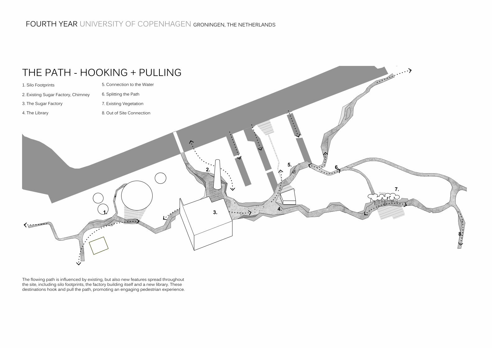
THE PATH - HOOKING + PULLING1.SiloFootprints
2.ExistingSugarFactory,Chimney
3.TheSugarFactory
4.TheLibrary
7.ExistingVegetation
8.OutofSiteConnection
5. Connection to the Water
6.SplittingthePath
Theflowingpathisinfluencedbyexisting,butalsonewfeaturesspreadthroughoutthesite,includingsilofootprints,thefactorybuildingitselfandanewlibrary.Thesedestinationshookandpullthepath,promotinganengagingpedestrianexperience.
1. 3. 4.
5. 6.
7.
8.
2.
FOURTH YEAR UNIVERSITY OF COPENHAGEN GRONINGEN, THE NETHERLANDS
Visualisationofthe‘flowingpath’enteringapublicspaceframedbythelibraryandcanal.
WATERFRONT NEIGHBOURHOOD
PHASING
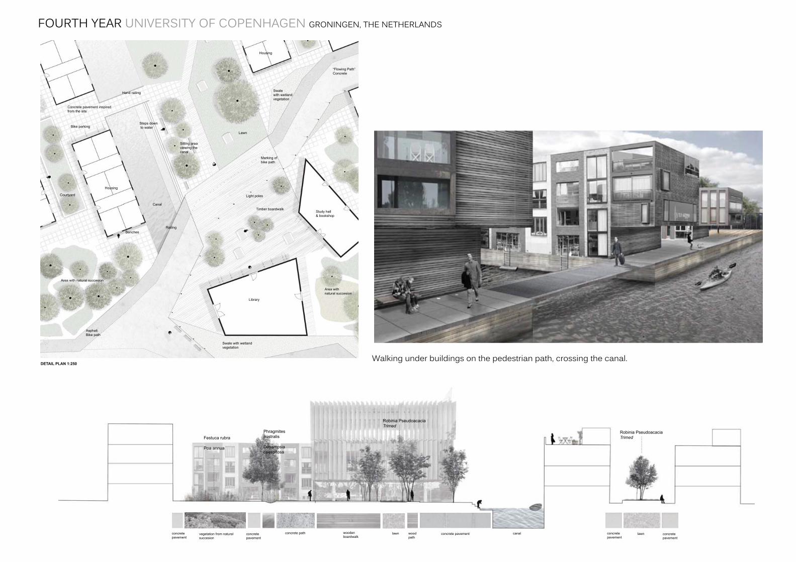
This neighborhood is intergrated into a series of new canals. By making smaller canals perpendicular to the existing canal, residents will have the water at their doorstep, having a strong connection with the recreational waterways. This area is inspired by Sluseholmen in Copenhagen, particularly by the buildings that having differing facades, but similar apartment sizes.
The concrete paving is inspired by the existing concrete landscape, which was the sugar factory production area. Up to the existing canal there is the same material where people can stay. In the small canals it is possible to walk down to the water, here we put in some stairs that reaches into the water. It is inspired of the fi elds with tides, where sometimes the water level is lower and you can use the last step to sit on. The neighbourhood has a public square which leads up to the existing canal. At the square there is a library and a reading hall, which fi ts well with the target group who are students.
Steps down to water
Sitting areaviewing the canal
Courtyard
The site will be gradually develope from small interventions, all the way to three new neighbourhoods, through a strategic evolution of the path, vegetation and built form.
Phase 1
It is important to note what qualities the site already has. The factory building serves as a restaurant and exhibition space, while the kitchen gardens serve as a catalyst for community involvement and greener living. It is hoped that through community engagement, the site will take on the identity of the residents that may one day inhabit the site.
The existing silo traces should be acknowledged with plantings and benches, while temporary way fi nding markers and lights hint at where future connections will be made along the fl owing path. Some trees are planted in the succession areas.
Phase 2
The ‘Remnants District’ neighbourhood is built, as there is existing road access over the railway. This development hopes to accentuate the existing character of the site. The western side of the fl owing path is built, including wetland vegetation and trees The pedestrian and cycle bridge over the canal is important in connecting the site, as it is currently isolated. The new market space and the creative workshop also encourage more community engagement.
Phase 3
The ‘Waterfront Neighbourhood’ is a larger scale addition to the site. The creation of three new canals creates a public space that closer engages with the water. A new limb to the fl owing path is necessary to connect the new neighbourhood to the factory plaza and Remnants District. A road and carpark fa-cilitate an increased population and also provides service vehicle access. A library is built an encour-ages students to live in the site. The orchard is an evolution to the kitchen gardens.
Phase 4
The fi nal stage of development includes the remaining sections of the fl owing path and the new ‘Green Living’ area. The succession areas will continue to evolve and change as a new population will leave their mark by how they use the undefi ned space.
DETAIL PLAN 1:250
SECTION B-b 1:200
SPATIAL TYPOLOGY
NEIGHBOURHOOD CHARACTER
PHASE 1
PHASE 2
PHASE 3
PHASE 4
Robinia Pseudoacacia Trimed
Robinia Pseudoacacia Trimed
Festuca rubra
Poa annua
Phragmitesaustralis
Desampsiacaespitosa
Housing
Housing
Library
Canal
Lawn
Area with natural succesion
Study hall& bookshop
“Flowing Path”Concrete
Swalewith wetland vegetation
AsphaltBike path
Concrete pavement inspired from the site
Bike parking
Benches
Swale with wetland vegetation
Timber boardwalk
Light poles
It is possible to walk under the apartment buildings at the canal’s edge. This visual representation shows the pedestrian path, crossing the canal, towards the public square within the waterfront neighbourhood.
Area with natural succesion
Marking of bike path
Railing
Hand railing
Raised Grass CourtyardDesignated resting area between the apartments along the canal. A small level change denotes a change in space from pedestrian path to sitting areas.
Canal StepsEngaging with the water which is characteristic to the neighbourhood. Offers a different recreational space as well as a public gathering point.
woodenboardwalk
concrete pathvegetation from natural succesion
lawn woodpath
lawncanalconcrete pavementconcretepavement
concretepavement
concretepavement
concretepavement
WATERFRONT NEIGHBOURHOOD
PHASING
This neighborhood is intergrated into a series of new canals. By making smaller canals perpendicular to the existing canal, residents will have the water at their doorstep, having a strong connection with the recreational waterways. This area is inspired by Sluseholmen in Copenhagen, particularly by the buildings that having differing facades, but similar apartment sizes.
The concrete paving is inspired by the existing concrete landscape, which was the sugar factory production area. Up to the existing canal there is the same material where people can stay. In the small canals it is possible to walk down to the water, here we put in some stairs that reaches into the water. It is inspired of the fi elds with tides, where sometimes the water level is lower and you can use the last step to sit on. The neighbourhood has a public square which leads up to the existing canal. At the square there is a library and a reading hall, which fi ts well with the target group who are students.
Steps down to water
Sitting areaviewing the canal
Courtyard
The site will be gradually develope from small interventions, all the way to three new neighbourhoods, through a strategic evolution of the path, vegetation and built form.
Phase 1
It is important to note what qualities the site already has. The factory building serves as a restaurant and exhibition space, while the kitchen gardens serve as a catalyst for community involvement and greener living. It is hoped that through community engagement, the site will take on the identity of the residents that may one day inhabit the site.
The existing silo traces should be acknowledged with plantings and benches, while temporary way fi nding markers and lights hint at where future connections will be made along the fl owing path. Some trees are planted in the succession areas.
Phase 2
The ‘Remnants District’ neighbourhood is built, as there is existing road access over the railway. This development hopes to accentuate the existing character of the site. The western side of the fl owing path is built, including wetland vegetation and trees The pedestrian and cycle bridge over the canal is important in connecting the site, as it is currently isolated. The new market space and the creative workshop also encourage more community engagement.
Phase 3
The ‘Waterfront Neighbourhood’ is a larger scale addition to the site. The creation of three new canals creates a public space that closer engages with the water. A new limb to the fl owing path is necessary to connect the new neighbourhood to the factory plaza and Remnants District. A road and carpark fa-cilitate an increased population and also provides service vehicle access. A library is built an encour-ages students to live in the site. The orchard is an evolution to the kitchen gardens.
Phase 4
The fi nal stage of development includes the remaining sections of the fl owing path and the new ‘Green Living’ area. The succession areas will continue to evolve and change as a new population will leave their mark by how they use the undefi ned space.
DETAIL PLAN 1:250
SECTION B-b 1:200
SPATIAL TYPOLOGY
NEIGHBOURHOOD CHARACTER
PHASE 1
PHASE 2
PHASE 3
PHASE 4
Robinia Pseudoacacia Trimed
Robinia Pseudoacacia Trimed
Festuca rubra
Poa annua
Phragmitesaustralis
Desampsiacaespitosa
Housing
Housing
Library
Canal
Lawn
Area with natural succesion
Study hall& bookshop
“Flowing Path”Concrete
Swalewith wetland vegetation
AsphaltBike path
Concrete pavement inspired from the site
Bike parking
Benches
Swale with wetland vegetation
Timber boardwalk
Light poles
It is possible to walk under the apartment buildings at the canal’s edge. This visual representation shows the pedestrian path, crossing the canal, towards the public square within the waterfront neighbourhood.
Area with natural succesion
Marking of bike path
Railing
Hand railing
Raised Grass CourtyardDesignated resting area between the apartments along the canal. A small level change denotes a change in space from pedestrian path to sitting areas.
Canal StepsEngaging with the water which is characteristic to the neighbourhood. Offers a different recreational space as well as a public gathering point.
woodenboardwalk
concrete pathvegetation from natural succesion
lawn woodpath
lawncanalconcrete pavementconcretepavement
concretepavement
concretepavement
concretepavement
FOURTH YEAR UNIVERSITY OF COPENHAGEN GRONINGEN, THE NETHERLANDS
Walkingunderbuildingsonthepedestrianpath,crossingthecanal.
THE PATH - EXPERIENCE
THE PATH - HOOKING + PULLING
EXPOSED WATER AND WETLAND VEGETATION SLOPING PATH AND SEATING
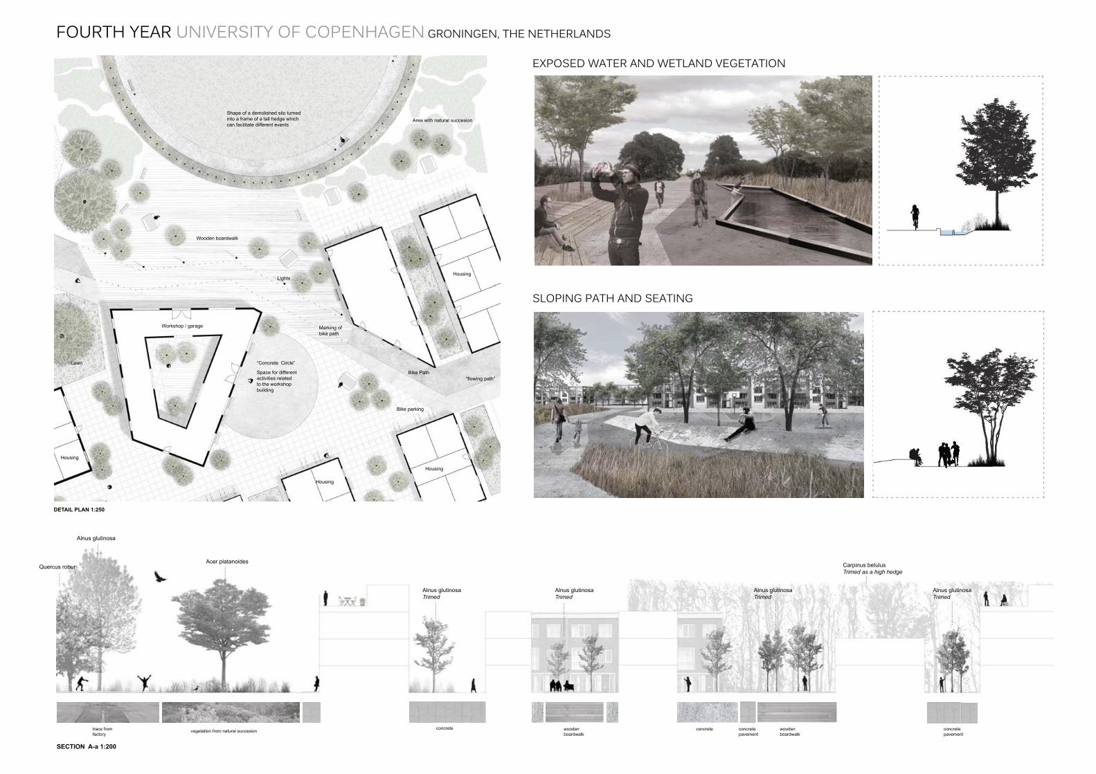
By making deeper areas beside the path and putting in some high grasses, some of the water will get into there. The path slopes up to provide an informal seating area besides public space.
REMNANTS DISTRICT
This neighborhood is dominated by existing traces from the old sugar factory. The circular traces will be the focal point here, and new circular forms have been created to emphasize the existing traces. They are visible through a shift in material, from pavers to in situ concrete. The event space is linked by a wooden deck, including benches and trees, to the worksop building. This public building is a place to be creative and produce art, possibly infl uenced by the industrial surrounds and unique forms of the sugar factory. The silo traces within the succession area act as a cleared space which contrasts to the dense vegetation, retaining the essense of the old factory.
The fl owing path is infl uenced by existing, but also new features spread throughout the site, including silo footprints, the factory building itself and a new library. These destina-tions hook and pull the path, promoting an engaging pedestrian experience.
The organic shape of the delta is sometimes challenged to accommodate a more geo-metric form. The scale of the site encourages varying path typologies, with smaller ‘ar-teries’ breaking up some of the larger spaces created by the primary path. The edges, where the interactions between open path space and its surroundings occur, will have differing and interesting forms that will encourage varying experiences such as intermit-tent water channels, sloping surfaces and vegetated retention beds.
1. Silo Footprints
Industrial traces pull pedestrian movement up from entry point over the railway. Silo footprints provide new spaces for events and a link to the site’s heritage.
2. Existing Sugar Factory, Chimney
Despite a linear visual axis from the pedestrian bridge to the factory building, the path winds around the monumental chimney, pushing the new market space to the east.
3. The Sugar Factory
From east to west, the path bends towards and ‘fl ows into’ the main entrance of the building so it becomes fully intergrated in the large site.
4. The Library
The library is located centrally within the site and is a new addition that the path hooks onto. Being at a major junction, the library will be busy with the large student population.
7. Existing Vegetation
The existing willow trees are an inspiration for a green environment where the built form is closely connected to dense vegetation and has an easy access to greenhouses.
8. Out of Site Connection
The path bends south towards a large recreational park, Stradpark. This entry point avoids the large nursery buildings and links onto existing footpaths.
1. 3.4.
5. 6.
7.
8.
2.
5. Connection to the Water
The northern artilary of the path provides access to the new canals in the water-front neighbourhood.
6. Splitting the Path
Responding to the change in width of the site as the path moves further east, the part divides itself like a delta and connects the new neighbourhoods.
Workshop / garage
“fl owing path”Bike Path
Bike parking
Shape of a demolished silo turned into a frame of a tall hedge which can facilitate different events
Marking of bike path
“Concrete Circle”
Space for different activities related to the workshop building
Wooden boardwalk
Lights
Housing
Acer platanoides
Alnus glutinosa
Alnus glutinosaTrimed
Alnus glutinosaTrimed
Alnus glutinosaTrimed
Alnus glutinosaTrimed
Carpinus betulusTrimed as a high hedge
Quercus robur
Housing
Area with natural succesion
The largest circle, in the scale of a demolished silo, will become a circular performance space lined by trees. It is meant to be used as an outdoor event square where theaters, concerts and outdoor cinema can be arranged. In the winter time these events can be held in the factory building.
Free-roaming PathRaw materiality of concrete referencing indus-trial past, marked by grass emerging through the edges.
SPATIAL TYPOLOGY
DETAIL PLAN 1:250
Preserving TracesUsing existing site elements to retain a ‘sense of place’. The old concrete will contrast to new built forms and provide a point of interest in the neighbourhood.
Housing
Housing
Lawn
SECTION A-a 1:200
NEIGHBOURHOOD CHARACTER
woodenboardwalk
woodenboardwalk
trace from factory
concrete concretepavement
concretepavement
concretevegetation from natural succesion
THE PATH - EXPERIENCE
THE PATH - HOOKING + PULLING
EXPOSED WATER AND WETLAND VEGETATION SLOPING PATH AND SEATING
By making deeper areas beside the path and putting in some high grasses, some of the water will get into there. The path slopes up to provide an informal seating area besides public space.
REMNANTS DISTRICT
This neighborhood is dominated by existing traces from the old sugar factory. The circular traces will be the focal point here, and new circular forms have been created to emphasize the existing traces. They are visible through a shift in material, from pavers to in situ concrete. The event space is linked by a wooden deck, including benches and trees, to the worksop building. This public building is a place to be creative and produce art, possibly infl uenced by the industrial surrounds and unique forms of the sugar factory. The silo traces within the succession area act as a cleared space which contrasts to the dense vegetation, retaining the essense of the old factory.
The fl owing path is infl uenced by existing, but also new features spread throughout the site, including silo footprints, the factory building itself and a new library. These destina-tions hook and pull the path, promoting an engaging pedestrian experience.
The organic shape of the delta is sometimes challenged to accommodate a more geo-metric form. The scale of the site encourages varying path typologies, with smaller ‘ar-teries’ breaking up some of the larger spaces created by the primary path. The edges, where the interactions between open path space and its surroundings occur, will have differing and interesting forms that will encourage varying experiences such as intermit-tent water channels, sloping surfaces and vegetated retention beds.
1. Silo Footprints
Industrial traces pull pedestrian movement up from entry point over the railway. Silo footprints provide new spaces for events and a link to the site’s heritage.
2. Existing Sugar Factory, Chimney
Despite a linear visual axis from the pedestrian bridge to the factory building, the path winds around the monumental chimney, pushing the new market space to the east.
3. The Sugar Factory
From east to west, the path bends towards and ‘fl ows into’ the main entrance of the building so it becomes fully intergrated in the large site.
4. The Library
The library is located centrally within the site and is a new addition that the path hooks onto. Being at a major junction, the library will be busy with the large student population.
7. Existing Vegetation
The existing willow trees are an inspiration for a green environment where the built form is closely connected to dense vegetation and has an easy access to greenhouses.
8. Out of Site Connection
The path bends south towards a large recreational park, Stradpark. This entry point avoids the large nursery buildings and links onto existing footpaths.
1. 3.4.
5. 6.
7.
8.
2.
5. Connection to the Water
The northern artilary of the path provides access to the new canals in the water-front neighbourhood.
6. Splitting the Path
Responding to the change in width of the site as the path moves further east, the part divides itself like a delta and connects the new neighbourhoods.
Workshop / garage
“fl owing path”Bike Path
Bike parking
Shape of a demolished silo turned into a frame of a tall hedge which can facilitate different events
Marking of bike path
“Concrete Circle”
Space for different activities related to the workshop building
Wooden boardwalk
Lights
Housing
Acer platanoides
Alnus glutinosa
Alnus glutinosaTrimed
Alnus glutinosaTrimed
Alnus glutinosaTrimed
Alnus glutinosaTrimed
Carpinus betulusTrimed as a high hedge
Quercus robur
Housing
Area with natural succesion
The largest circle, in the scale of a demolished silo, will become a circular performance space lined by trees. It is meant to be used as an outdoor event square where theaters, concerts and outdoor cinema can be arranged. In the winter time these events can be held in the factory building.
Free-roaming PathRaw materiality of concrete referencing indus-trial past, marked by grass emerging through the edges.
SPATIAL TYPOLOGY
DETAIL PLAN 1:250
Preserving TracesUsing existing site elements to retain a ‘sense of place’. The old concrete will contrast to new built forms and provide a point of interest in the neighbourhood.
Housing
Housing
Lawn
SECTION A-a 1:200
NEIGHBOURHOOD CHARACTER
woodenboardwalk
woodenboardwalk
trace from factory
concrete concretepavement
concretepavement
concretevegetation from natural succesion
FOURTH YEAR UNIVERSITY OF COPENHAGEN GRONINGEN, THE NETHERLANDS
EXPOSED WATER AND WETLAND VEGETATION
SLOPING PATH AND SEATING
GREEN LIVING
VEGETATION TYPOLOGY SUCCESSION - KITCHEN GARDEN - ORCHARD
Principles of the succession areas:The ‘design’ of the succession areas is inspired by Gilles Clemént’s “Third Landscape”. “The Third Landscape” can be considered as the genetic reservoir of the planet. These spaces are left over to evolution and natural succession, the nature alone has the power. Biodiversity is high and selfgrown plants are possible. In some way, you can say it is a biological bank.
The succession areas start to break down the asphalt and replace it with trees, both fast growing and slow growing. The fast growing trees will die early and then the slow growing trees will take over. Self established bushes, like blackberry, will be established and animals will be attracted to the area. After 10 years, paths will be installed to ensure people can experience the unkept nature.
A self productive community - a programme: The area already has some existing kitchen gardens where vegetables and herbs are grown for the restaurant. This idea is taken further,with more garden beds placed, so there is enough for the new residents living on the site. Small orchards of different kind of fruits, such as apples, will also be created. The fruit trees will be aligned in rows in the same direction as the of the buildings, to maintain the geometric contrast of the design.
Beside the orchard, new greenhouses are placed, where vegetables can grow in a controlled evnironment to improve production The size of the greenhouses is 10x5 metres. The vegetables should be made affordable, sold in the surrounding neighbourhoods. The money will go to put back into the production, employees and maintenance of the orchard.
The fi rst year: Slow growing Quercus robur, and fastgrowing Acer platanoides and Alnus glutinosa is planted. Grass is already growing. Different temporary activities will be established, e.g. playground.
After 10 years:The Alnus glutinosa is almost fully grown and the Acer platanoides has grown bigger. High grass and some bushes are established. Temporary acitivities replaced by path. Birdlife starts to inhabit vegetation.
After 50 years:The lifetime of Alnus glutinosas is over and the Acer platanoides and the Quercus robur dominate the land-scape. More bushes are established and wildlife lives in the area.
Quercusrobur
AlnusglutionsaAcer
platanoides
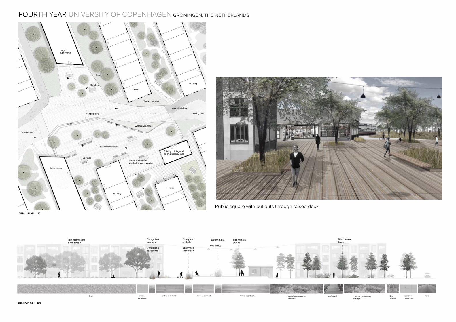
The eastern neighbourhood, inspired by existing vegetation, is seen as a ‘green living’ area where the built form is closely connected to dense vegetation and has easy access to the greenhouses, orchards and kitchen gardens close by. Here, the wetland vegetation beds divide the public space, making more intimate spaces which give a feeling of being closer to nature. The public square, a raised wooden deck, also facilitates high grasses growing up from rectangular cut outs. This variation in height makes the the square visually stand out.
In general, the density of vegetation in the Green Living area are higher than in the other neighborhoods. It also links to the Stadpark. The public buildings will include a large shopping centre and grocers where residents can buy, among others, vegetables, herbes and fruit produced locally at the site.
DETAIL PLAN 1:250
SECTION Cc 1:200
SPATIAL TYPOLOGY
NEIGHBOURHOOD CHARACTER
Festuca rubra
Poa annua
Tilia platyphyllosSemi trimed
Tilia cordataTrimed
Tilia cordataTrimed
Phragmitesaustralis
Desampsiacaespitosa
Phragmitesaustralis
Desampsiacaespitosa
Public square, cut outs through raised deck
Housing
Housing
Housing
Housing
Cutout of boardwalkwith high grass vegetation
Benches
Mixed shops
Largesupermarket
Benches
Lawn
Existing building used as small grocery shop
Wooden boardwalk
Steps
Steps
Hanging lights
Wetland vegetation
Wetland vegetation
“Flowing Path”
“Flowing Path”
Asphalt bikelane
Informal Defi ned PathAcknowledging the spatial form of vegetation by intro-ducing a winding path between trees.
Formal Defi ned PathThe path takes precedent over trees which border pe-destrian movement in a linear form.
SUCCESSION AREA
ORCHARDS AND KITCHEN GARDENS
timber boardwalk roadconcretepavement
bikeparking
winding pathcontrolled successionplantings
controlled successionplantings
timber boardwalktimber boardwalklawn concretepavement
GREEN LIVING
VEGETATION TYPOLOGY SUCCESSION - KITCHEN GARDEN - ORCHARD
Principles of the succession areas:The ‘design’ of the succession areas is inspired by Gilles Clemént’s “Third Landscape”. “The Third Landscape” can be considered as the genetic reservoir of the planet. These spaces are left over to evolution and natural succession, the nature alone has the power. Biodiversity is high and selfgrown plants are possible. In some way, you can say it is a biological bank.
The succession areas start to break down the asphalt and replace it with trees, both fast growing and slow growing. The fast growing trees will die early and then the slow growing trees will take over. Self established bushes, like blackberry, will be established and animals will be attracted to the area. After 10 years, paths will be installed to ensure people can experience the unkept nature.
A self productive community - a programme: The area already has some existing kitchen gardens where vegetables and herbs are grown for the restaurant. This idea is taken further,with more garden beds placed, so there is enough for the new residents living on the site. Small orchards of different kind of fruits, such as apples, will also be created. The fruit trees will be aligned in rows in the same direction as the of the buildings, to maintain the geometric contrast of the design.
Beside the orchard, new greenhouses are placed, where vegetables can grow in a controlled evnironment to improve production The size of the greenhouses is 10x5 metres. The vegetables should be made affordable, sold in the surrounding neighbourhoods. The money will go to put back into the production, employees and maintenance of the orchard.
The fi rst year: Slow growing Quercus robur, and fastgrowing Acer platanoides and Alnus glutinosa is planted. Grass is already growing. Different temporary activities will be established, e.g. playground.
After 10 years:The Alnus glutinosa is almost fully grown and the Acer platanoides has grown bigger. High grass and some bushes are established. Temporary acitivities replaced by path. Birdlife starts to inhabit vegetation.
After 50 years:The lifetime of Alnus glutinosas is over and the Acer platanoides and the Quercus robur dominate the land-scape. More bushes are established and wildlife lives in the area.
Quercusrobur
AlnusglutionsaAcer
platanoides
The eastern neighbourhood, inspired by existing vegetation, is seen as a ‘green living’ area where the built form is closely connected to dense vegetation and has easy access to the greenhouses, orchards and kitchen gardens close by. Here, the wetland vegetation beds divide the public space, making more intimate spaces which give a feeling of being closer to nature. The public square, a raised wooden deck, also facilitates high grasses growing up from rectangular cut outs. This variation in height makes the the square visually stand out.
In general, the density of vegetation in the Green Living area are higher than in the other neighborhoods. It also links to the Stadpark. The public buildings will include a large shopping centre and grocers where residents can buy, among others, vegetables, herbes and fruit produced locally at the site.
DETAIL PLAN 1:250
SECTION Cc 1:200
SPATIAL TYPOLOGY
NEIGHBOURHOOD CHARACTER
Festuca rubra
Poa annua
Tilia platyphyllosSemi trimed
Tilia cordataTrimed
Tilia cordataTrimed
Phragmitesaustralis
Desampsiacaespitosa
Phragmitesaustralis
Desampsiacaespitosa
Public square, cut outs through raised deck
Housing
Housing
Housing
Housing
Cutout of boardwalkwith high grass vegetation
Benches
Mixed shops
Largesupermarket
Benches
Lawn
Existing building used as small grocery shop
Wooden boardwalk
Steps
Steps
Hanging lights
Wetland vegetation
Wetland vegetation
“Flowing Path”
“Flowing Path”
Asphalt bikelane
Informal Defi ned PathAcknowledging the spatial form of vegetation by intro-ducing a winding path between trees.
Formal Defi ned PathThe path takes precedent over trees which border pe-destrian movement in a linear form.
SUCCESSION AREA
ORCHARDS AND KITCHEN GARDENS
timber boardwalk roadconcretepavement
bikeparking
winding pathcontrolled successionplantings
controlled successionplantings
timber boardwalktimber boardwalklawn concretepavement
FOURTH YEAR UNIVERSITY OF COPENHAGEN GRONINGEN, THE NETHERLANDS
Publicsquarewithcutoutsthroughraiseddeck.
A B
A
B
<
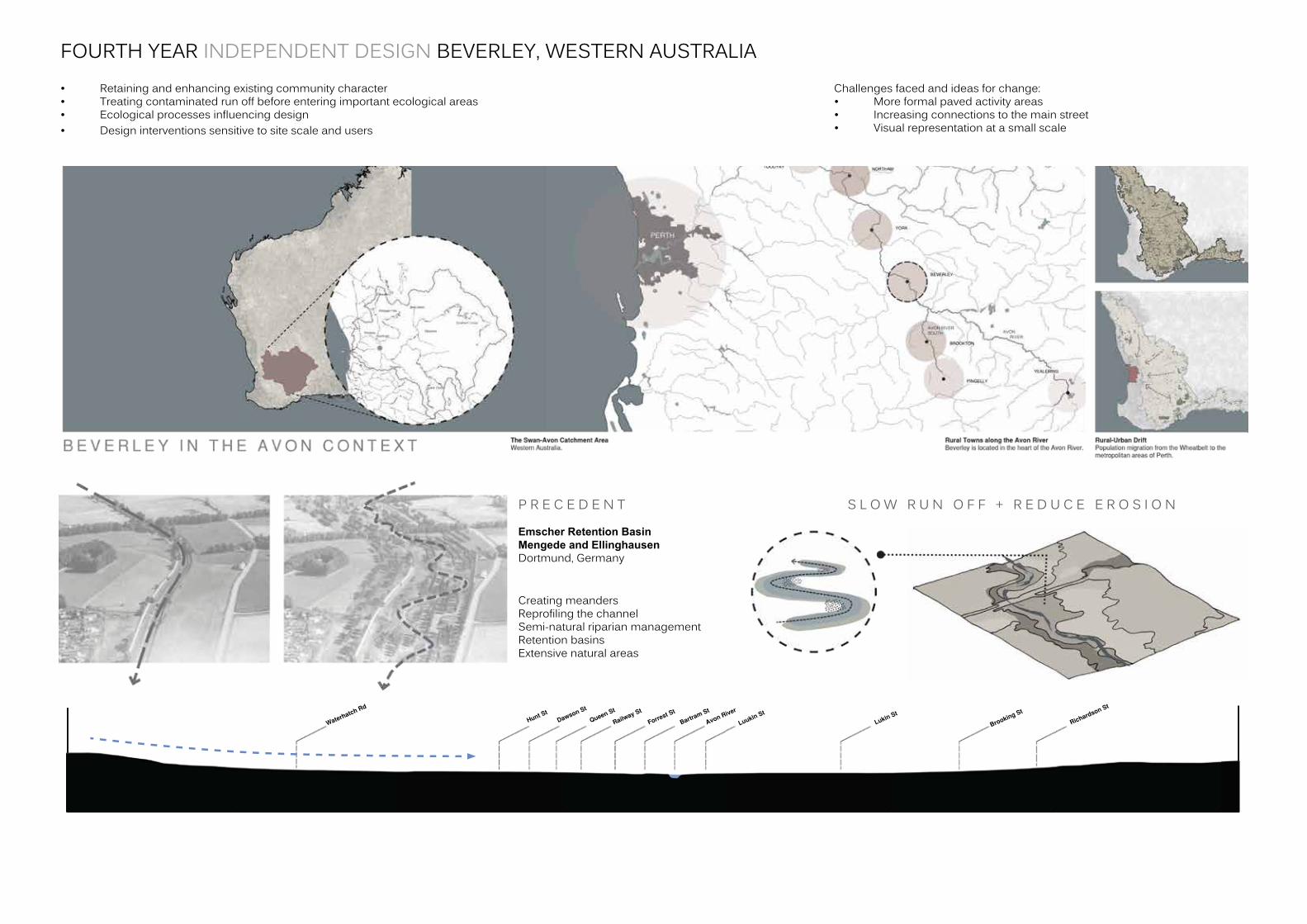
FOURTH YEAR INDEPENDENT DESIGN BEVERLEY, WESTERN AUSTRALIA• Retainingandenhancingexistingcommunitycharacter• Treatingcontaminatedrunoffbeforeenteringimportantecologicalareas• Ecologicalprocessesinfluencingdesign• Designinterventionssensitivetositescaleandusers
Challengesfacedandideasforchange:• Moreformalpavedactivityareas• Increasingconnectionstothemainstreet• Visualrepresentationatasmallscale
CreatingmeandersReprofilingthechannelSemi-naturalriparianmanagementRetentionbasinsExtensivenaturalareas
P R E C E D E N T
Emscher Retention Basin Mengede and EllinghausenDortmund,Germany
S L O W R U N O F F + R E D U C E E R O S I O N
FOURTH YEAR INDEPENDENT DESIGN BEVERLEY, WESTERN AUSTRALIA
FOURTH YEAR INDEPENDENT DESIGN BEVERLEY, WESTERN AUSTRALIA
FOURTH YEAR INDEPENDENT DESIGN BEVERLEY, WESTERN AUSTRALIA
1
4
5
6
2
3
ENTRY STATEMENT
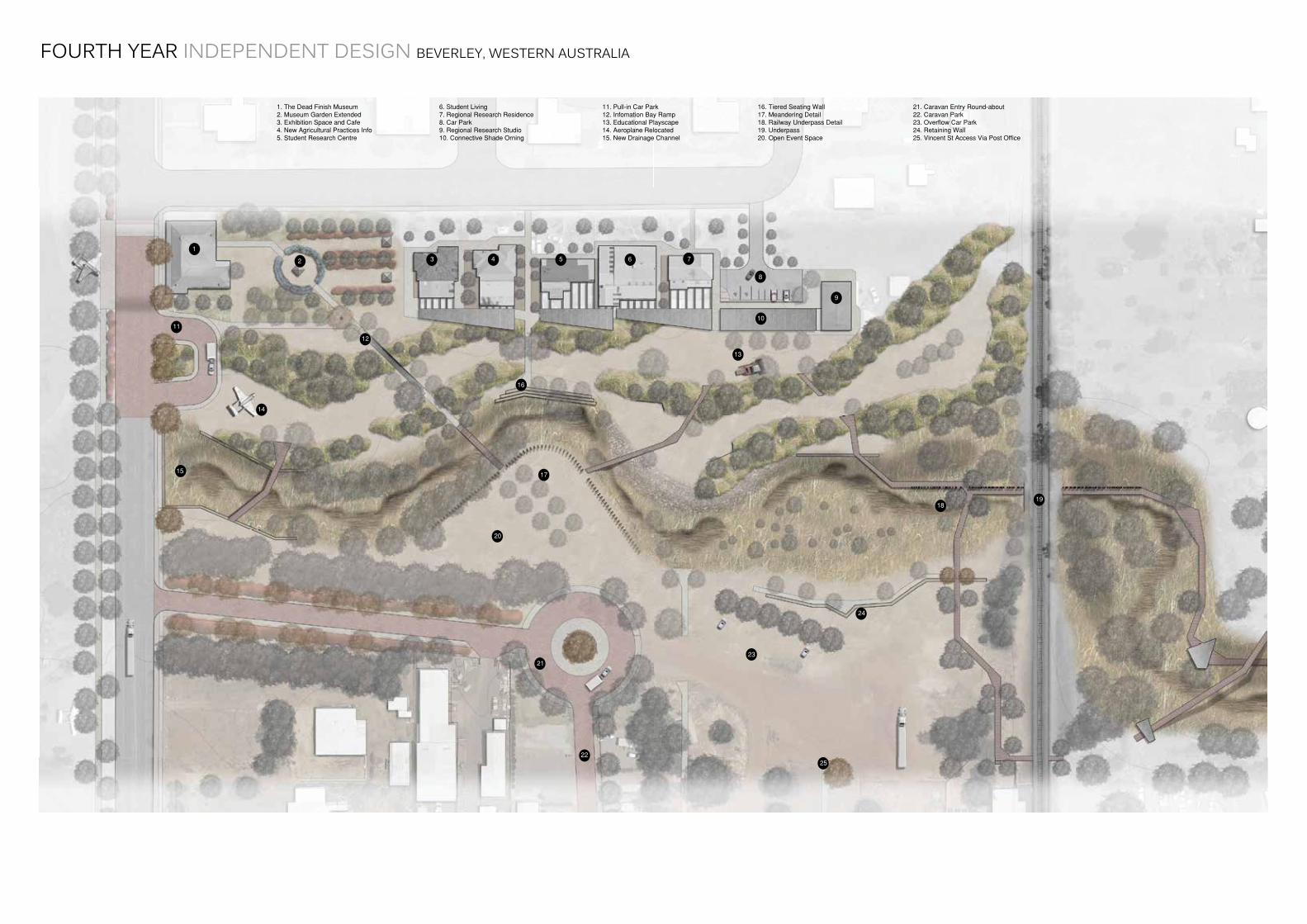
It makes sense that the petrol station lies at the gateway to the town centre on Vincent Street as many travellers along the Great Southern Highway would top up for petrol on their journey to and from other rural centres such as neighbouring Brookton, York and Northam.
While the building is iconic, this entrance statement requires attention.
AGRICULTURAL RUN-OFF
Drainage from farmland to the west of Hunt Rd and Great Southern Highway is all channelled into a condensed dam catchment.
While this may create a visual focal point having an exposed body of water, the run off water doesnit pass through bio-fi ltration swales before it reaches the Avon. This should be addressed.
EXISTING VEGETATION
The sculptural form of the Eucalypts and other native Australian fl ora on the site just to the north of Vincent Street gives it a recognisably Australian landscape character.
This site should be further explored and used as a catalyst to reintroduce endemic vegetation back to the town centre and its surrounds.
HERITAGE OPPORTUNITY
The Dead End Museum offers just a taste of Beverley’s rich cultural heritage.
Like many rural townships in the Western Australian wheatbelt, the town’s architecture offers a glimpse of the past.
The museum itself has been re-stored and is a major attraction of Beverley.
SHADE OVER-HANG
Extended eves along the North facing facade have all changed and added to the character of the main street. The differing styles of archi-tecture have all adapted to the site conditions of the fi ece sunlight and resulting heat experienced along pedestrian corridors.
Shade must be integrated integrated in any future designed response.
BEVERLEY ‘ON DISPLAY’
From the Art Gallery at the Train Station to the old glyders spoked up on sticks, it seems the residents of Beverley are keen to show off what makes the town unique with an eye on tourism.
The querky nature of the planes, the vivid red chairs and eclectic built form create a welcomingfeeling to passing guests.
1
3
5
6
2
4
Access via Vincent Street and along Hunt StreetThe existing path network is overshadowed by the heavy vehicle traffi c along Hunt Street coming from York and Northam. An extended avenue of trees with a foreground groundcover will allow for comfortable pedestrian access. The Hunt Street facade also needs to stand out further to engage passers by.
Pedestrian links should be made to Vincent Street via the Post offi ce building and museum.
1
4
5
6
2
3
ENTRY STATEMENT
It makes sense that the petrol station lies at the gateway to the town centre on Vincent Street as many travellers along the Great Southern Highway would top up for petrol on their journey to and from other rural centres such as neighbouring Brookton, York and Northam.
While the building is iconic, this entrance statement requires attention.
AGRICULTURAL RUN-OFF
Drainage from farmland to the west of Hunt Rd and Great Southern Highway is all channelled into a condensed dam catchment.
While this may create a visual focal point having an exposed body of water, the run off water doesnit pass through bio-fi ltration swales before it reaches the Avon. This should be addressed.
EXISTING VEGETATION
The sculptural form of the Eucalypts and other native Australian fl ora on the site just to the north of Vincent Street gives it a recognisably Australian landscape character.
This site should be further explored and used as a catalyst to reintroduce endemic vegetation back to the town centre and its surrounds.
HERITAGE OPPORTUNITY
The Dead End Museum offers just a taste of Beverley’s rich cultural heritage.
Like many rural townships in the Western Australian wheatbelt, the town’s architecture offers a glimpse of the past.
The museum itself has been re-stored and is a major attraction of Beverley.
SHADE OVER-HANG
Extended eves along the North facing facade have all changed and added to the character of the main street. The differing styles of archi-tecture have all adapted to the site conditions of the fi ece sunlight and resulting heat experienced along pedestrian corridors.
Shade must be integrated integrated in any future designed response.
BEVERLEY ‘ON DISPLAY’
From the Art Gallery at the Train Station to the old glyders spoked up on sticks, it seems the residents of Beverley are keen to show off what makes the town unique with an eye on tourism.
The querky nature of the planes, the vivid red chairs and eclectic built form create a welcomingfeeling to passing guests.
1
3
5
6
2
4
Access via Vincent Street and along Hunt StreetThe existing path network is overshadowed by the heavy vehicle traffi c along Hunt Street coming from York and Northam. An extended avenue of trees with a foreground groundcover will allow for comfortable pedestrian access. The Hunt Street facade also needs to stand out further to engage passers by.
Pedestrian links should be made to Vincent Street via the Post offi ce building and museum.
FOURTH YEAR INDEPENDENT DESIGN BEVERLEY, WESTERN AUSTRALIA
InvestigativecollagesketchesuncoveringthecharacterofBeverley.
THIRD YEAR GARDEN STUDIO FREMANTLE, WESTERN AUSTRALIA
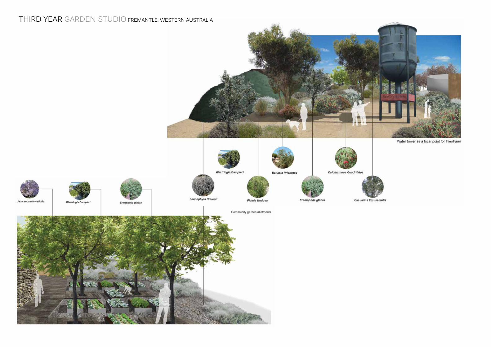
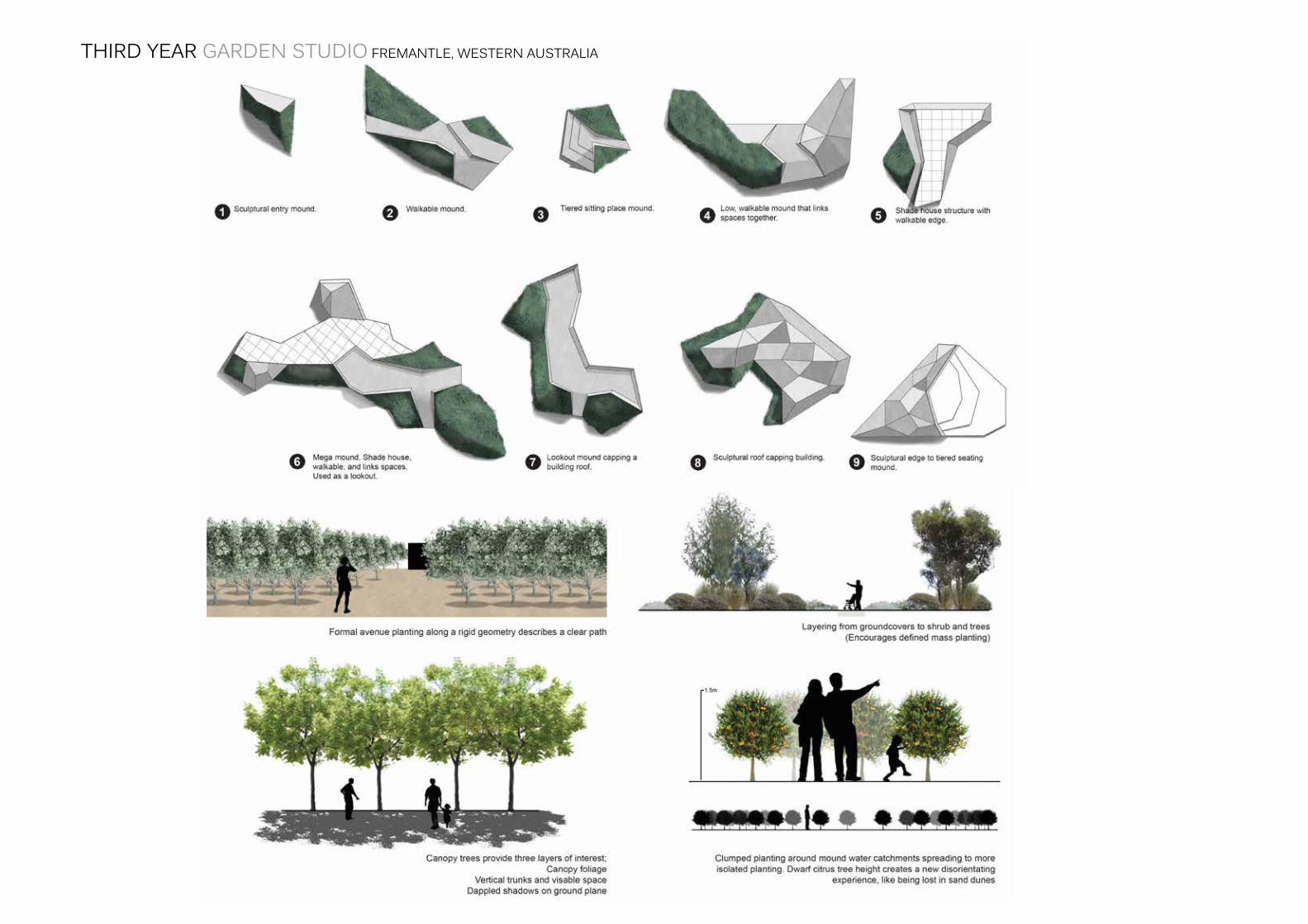
• Contaminatedsiteremediation• Designfromgridpatterninfluencedbyexistinglandformsandvegetation• Multiplefunctionsformoundelements• Diversepedestriananduserexperiencethroughplantingdesign• Activatingcommunityhotspots
Challengesfacedandideasforchange:• Furtherdetailinginsmallscale• Changingmoundformstoallowforsimplergroundinterventions• Moreappropriateplantingchoices
THIRD YEAR GARDEN STUDIO FREMANTLE, WESTERN AUSTRALIA
THIRD YEAR GARDEN STUDIO FREMANTLE, WESTERN AUSTRALIA
THIRD YEAR GARDEN STUDIO FREMANTLE, WESTERN AUSTRALIA
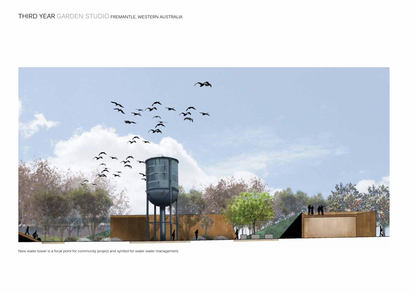
Newwatertowerisafocalpointforcommunityprojectandsymbolforwaterwatermanagement.
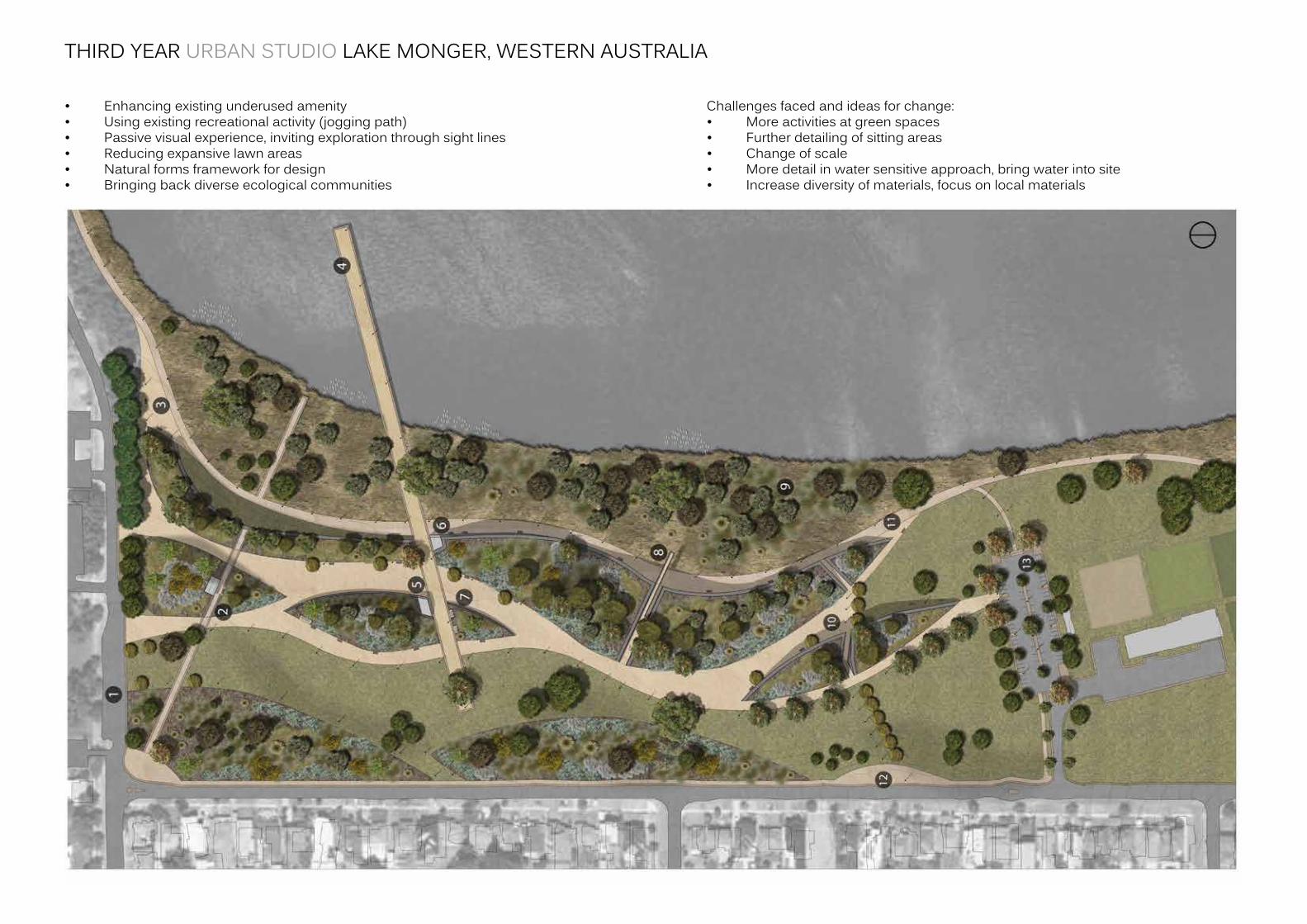
• Enhancingexistingunderusedamenity• Usingexistingrecreationalactivity(joggingpath)• Passivevisualexperience,invitingexplorationthroughsightlines• Reducingexpansivelawnareas• Naturalformsframeworkfordesign• Bringingbackdiverseecologicalcommunities
Challengesfacedandideasforchange:• Moreactivitiesatgreenspaces• Furtherdetailingofsittingareas• Changeofscale• Moredetailinwatersensitiveapproach,bringwaterintosite• Increasediversityofmaterials,focusonlocalmaterials
THIRD YEAR URBAN STUDIO LAKE MONGER, WESTERN AUSTRALIA
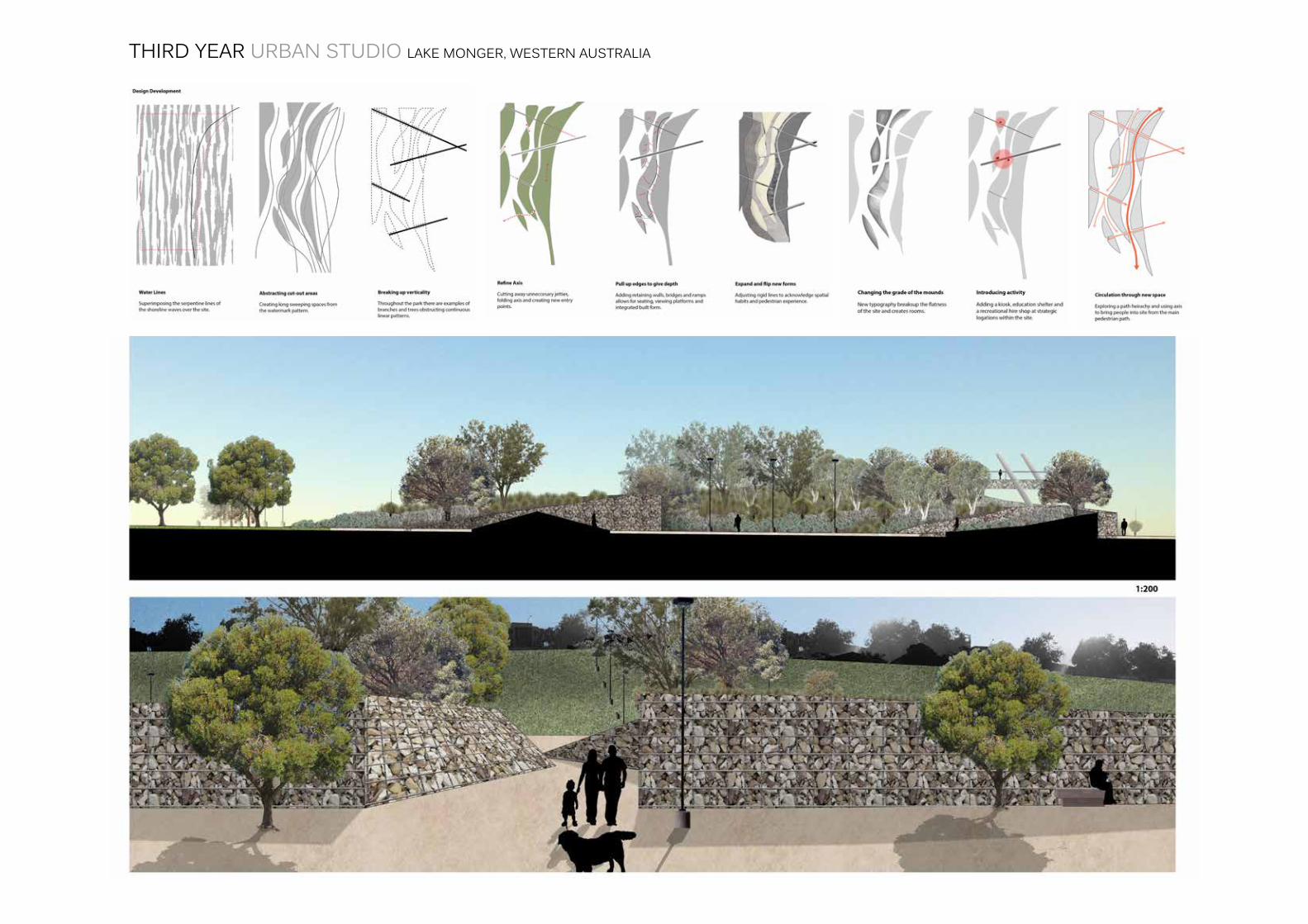
THIRD YEAR URBAN STUDIO LAKE MONGER, WESTERN AUSTRALIA
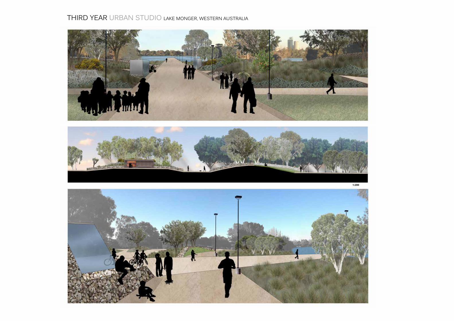
THIRD YEAR URBAN STUDIO LAKE MONGER, WESTERN AUSTRALIA
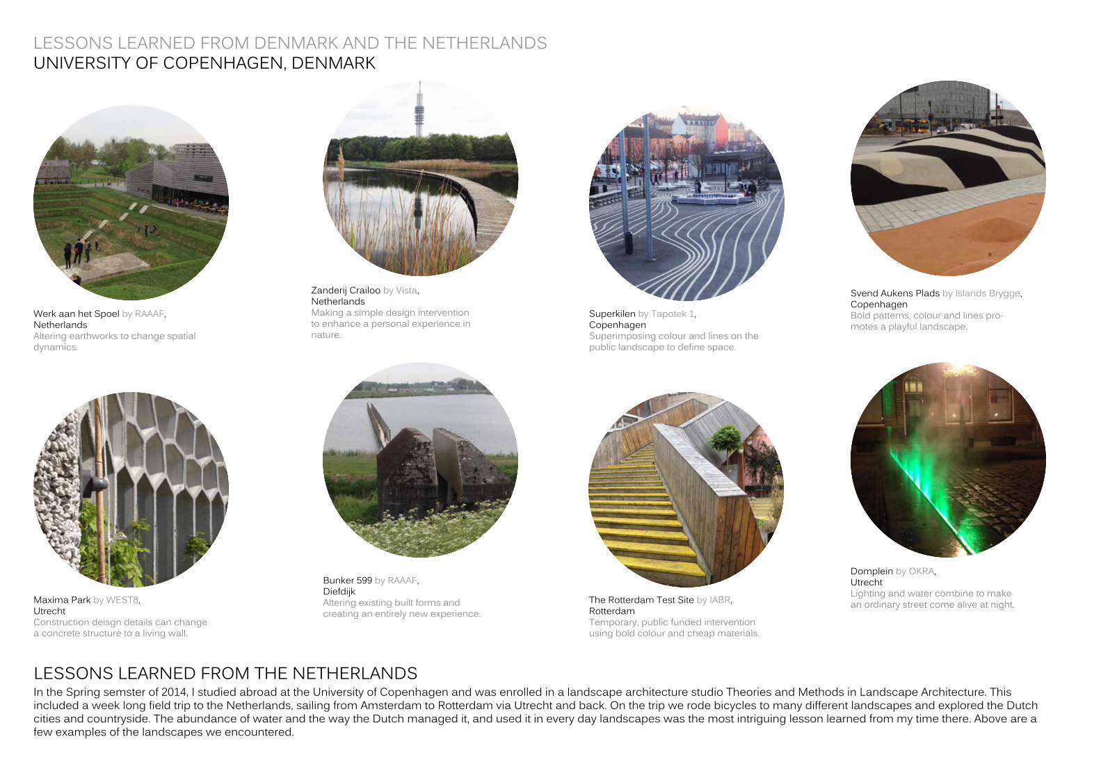
WerkaanhetSpoelbyRAAAF, NetherlandsAlteringearthworkstochangespatialdynamics.
MaximaParkbyWEST8,UtrechtConstructiondeisgndetailscanchangeaconcretestructuretoalivingwall.
Bunker599byRAAAF,DiefdijkAlteringexistingbuiltformsandcreatinganentirelynewexperience.
TheRotterdamTestSitebyIABR, RotterdamTemporary,publicfundedinterventionusingboldcolourandcheapmaterials.
DompleinbyOKRA, UtrechtLightingandwatercombinetomakeanordinarystreetcomealiveatnight.
ZanderijCrailoobyVista,NetherlandsMakingasimpledesigninterventiontoenhanceapersonalexperienceinnature.
SuperkilenbyTapotek1,CopenhagenSuperimposingcolourandlinesonthepubliclandscapetodefinespace.
SvendAukensPladsbyIslandsBrygge,CopenhagenBoldpatterns,colourandlinespro-motesaplayfullandscape.
LESSONS LEARNED FROM DENMARK AND THE NETHERLANDSUNIVERSITY OF COPENHAGEN, DENMARK
LESSONS LEARNED FROM THE NETHERLANDSIntheSpringsemsterof2014,IstudiedabroadattheUniversityofCopenhagenandwasenrolledinalandscapearchitecturestudioTheoriesandMethodsinLandscapeArchitecture.ThisincludedaweeklongfieldtriptotheNetherlands,sailingfromAmsterdamtoRotterdamviaUtrechtandback.OnthetripwerodebicyclestomanydifferentlandscapesandexploredtheDutchcitiesandcountryside.TheabundanceofwaterandthewaytheDutchmanagedit,anduseditineverydaylandscapeswasthemostintriguinglessonlearnedfrommytimethere.Aboveareafewexamplesofthelandscapesweencountered.
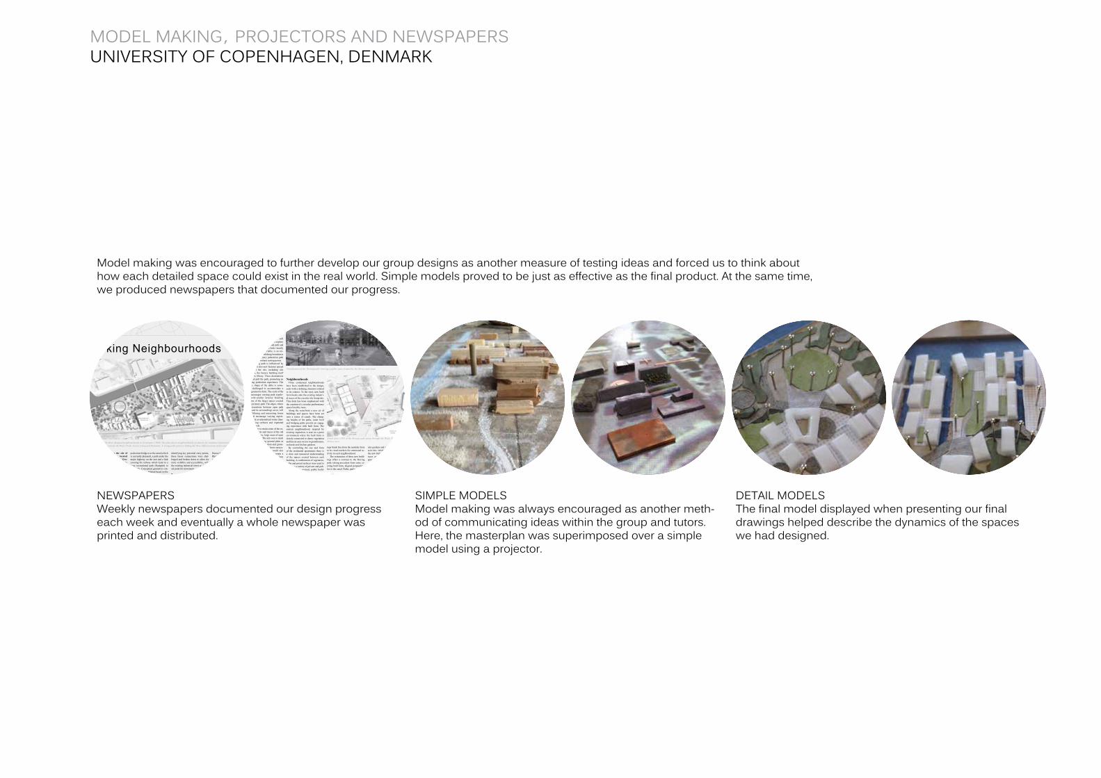
Modelmakingwasencouragedtofurtherdevelopourgroupdesignsasanothermeasureoftestingideasandforcedustothinkabouthoweachdetailedspacecouldexistintherealworld.Simplemodelsprovedtobejustaseffectiveasthefinalproduct.Atthesametime,weproducednewspapersthatdocumentedourprogress.
identifying key potential entry points, these linear connections were chal-lenged and broken down to allow for more visibility and accessibility, with the existing industrial tower as the fo-cal point for movement.
The ‘fl owing path’The shape of the path has been in-
Linking Neighbourhoods
Masterplan of the three designed neighbourhoods in Groningen 1:3000. The plan shows neighbourhoods (primarily for students) characterized by different exist-ing elements; respectively the Water Front, Green Living and Remnants. A strong path system is linking the three different areas and is making the walk variated.
This paper investigates the site of the Sugar Plant Territory located near the centre of the city of Gro-ningen in the Netherlands. By con-necting different housing areas and spaces through a strong path sys-tem, the design hopes to integrate a large student population with an old agricultural site, while retaining its existing industrial charm.
The city of Groningen has a popu-lation of almost 200,000 people, of which 25% are students. The Univer-sity of Groningen (Rijeksuniversiteit) and the Hanze University of Applied Science are the two higher educa-tional institutions in the city and are both located within 4 kilometres of the old sugar factory site. Housing is often unaffordable for the large stu-dent population, which includes 3750 international students. The site’s close proximity to the city centre and nearby University facilities offers potential as a new student accommodation zone.In the city of Groningen approximate-ly 50% of all trips within the city are made by bicycle, so easy access to bike lanes and bike parking are essential in the urban scene.
Reconnect Isolated Site Barriers to pedestrian movement
have isolated the site and connecting the former sugar factory area to its surroundings is seen as a vital step in bringing the site to life. Opportunities to repair these connections include a
pedestrian bridge over the canal (which is currently planned), a path under the major highway on the east and a link crossing the railway which leads to a large recreational park (Stadpark) to the south. Conceptual geometric con-nections were established based on the orientation of the existing buildings and paths that bordered the site. After
fl uenced by the organic forms of the Rhine-Meuse-Scheldt Delta, which runs through Belgium and the Neth-erlands. The fl owing path turns and weaves, like a delta, changing spaces and landscape as it meanders over the site. As the path turns, new view lines are created. Much like a delta carries and deposits sediment from upstream,
This diagram shows the concept with the three different neighbourhoods and a linking path between them.
The path is created by the criteria that the site links to areas that is sourroundingit and make the site more accesible.
Green living area: Defi ned path
Water Front area: Designated resting
Remnants area: Free roaming
Workshop
N
Remnants
Library and bookshop
Kitchengardens Orchards
Access to shopping and restaurants
Connection to Groningen city center
Connection to university
Connection to StadparkConnection to shopping
Connection to wetland fi elds
Event square for concerts
Market square
Pedestrian bridge
Green houses
Reading hall
A
a
Leftover spaces for vegetation and
natural selection
Car entry
Car park
Car park
Café
The water front
Green living
Wolkenfabriek Restaurant
Public square
L A N D S C A P E P L A N N I N G 2 0 1 4 • PA G E 1U N I V E R S I T Y O F C O P E N H A G E N
the path carries pedestrian movement and provides stopping points and open squares besides its primary transi-tional function. This allows people to engage with the space beside the path, whether it is public buildings, recrea-tional areas or existing traces of the factory site.
New designated open spaces will also allow for opportunities to explore beyond this main transitional path and connect the broader site both visually and physically. Materiality is an im-portant tool in establishing boundaries between the primary pedestrian path and these intermittent resting points.
The fl owing path is infl uenced by existing, but also new features spread throughout the site, including silo footprints, the factory building itself and a new library. These destinations hook and pull the path, promoting an engaging pedestrian experience. The organic shape of the delta is some-times challenged to accommodate a more geometric form. The scale of the site encourages varying path typolo-gies, with smaller ‘arteries’ breaking up some of the larger spaces created by the primary path. The edges, where the interactions between open path space and its surroundings occur, will have differing and interesting forms that will encourage varying experi-ences such as intermittent water chan-nels, sloping surfaces and vegetated retention beds.
In an effort to retain some of the ex-isting footprints and traces of the old factory landscape, large areas of open space were kept. The aim was to mesh some of the existing ground plain as ‘cut outs’, with vegetation and green-ways hinting at possible future spaces. These existing materials could also be used in future design to retain a sense of place, so that new built form belonged in this landscape. In this sense, the design is planning for the unplanned ways that people will use the site.
NeighbourhoodsThree condensed neighbourhoods
have been established in the design, each with a defi ning character related to its context. To the west, new built form hooks onto the existing industri-al traces of the circular silo footprints. This form has been emphasized with the creation of a circular performance space lined by trees.
Along the waterfront a new set of buildings and spaces have been set onto a series of canals. The chang-ing heights of the paths, water level and bridging paths provide an engag-ing experience with built form. The eastern neighbourhood, inspired by existing vegetation, is seen as a green environment where the built form is closely connected to dense vegetation and has an easy access to greenhouses, orchards and kitchen gardens.
By controlling the size and form of the residential apartments there is a clear and measured understanding of the spaces created between each building. A combination of vegetation, paths and paved surfaces were used to conceive a variety of private and pub-lic spaces. In contrast, public build-
ings break free from the modular form to be visual markers for communal ac-tivity in each neighbourhood.
The orientation of these new build-ings offers a contrast to the fl owing path, taking precedent from some ex-isting built form, aligned perpendicu-lar to the canal. Paths, parks, commu-
nity gardens and informal recreational activities inhabit the space between the new built form, while roof-top ter-races and balconies provide private spaces in the apartments.
Detail plan 1:500 of the fl owing path going through the Water Front and thelibrary area
Section 1:250 showing the Water Front area and the shift in materials in the public space
Visualisation of the ‘fl owing path’ entering a public space framed by the library and canal.
Alnus Glutinosa
Robinia pseudoacacia
Library and bookshop
Study hallStudent housing
Bikeparking
Benches
Benches
Courtyard
Grass lawn
Wetland vegetaion
Asphalt cycle path
Concrete pedestrian
path
Sitting area viewing the canal
Steps down to water
Library
Marking bike path
Wooden boardwalkWooden path
Submerged step
Concrete pathStudent housing
Roof top terasse
Canal
Shared space between buildings
Robinia pseudoacacia
Wetland vegetaion
L A N D S C A P E P L A N N I N G 2 0 1 4 • PA G E 2U N I V E R S I T Y O F C O P E N H A G E N
NEWSPAPERSWeeklynewspapersdocumentedourdesignprogresseachweekandeventuallyawholenewspaperwasprintedanddistributed.
SIMPLE MODELSModelmakingwasalwaysencouragedasanothermeth-odofcommunicatingideaswithinthegroupandtutors.Here,themasterplanwassuperimposedoverasimplemodelusingaprojector.
DETAIL MODELSThefinalmodeldisplayedwhenpresentingourfinaldrawingshelpeddescribethedynamicsofthespaceswehaddesigned.
MODEL MAKING, PROJECTORS AND NEWSPAPERS UNIVERSITY OF COPENHAGEN, DENMARK
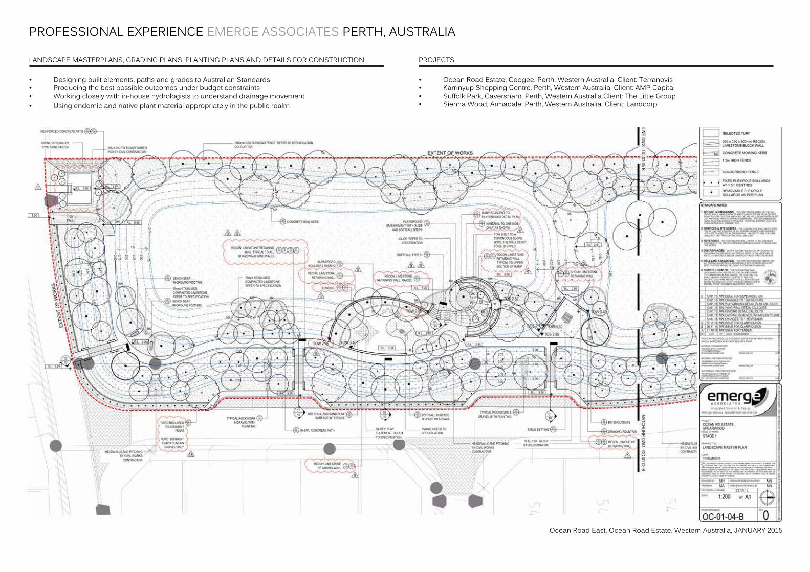
PROFESSIONAL EXPERIENCE EMERGE ASSOCIATES PERTH, AUSTRALIA
• Designingbuiltelements,pathsandgradestoAustralianStandards• Producingthebestpossibleoutcomesunderbudgetconstraints• Workingcloselywithin-househydrologiststounderstanddrainagemovement• Usingendemicandnativeplantmaterialappropriatelyinthepublicrealm
• OceanRoadEstate,Coogee.Perth,WesternAustralia.Client:Terranovis• KarrinyupShoppingCentre.Perth,WesternAustralia.Client:AMPCapital• SuffolkPark,Caversham.Perth,WesternAustralia.Client:TheLittleGroup• SiennaWood,Armadale.Perth,WesternAustralia.Client:Landcorp
LANDSCAPE MASTERPLANS, GRADING PLANS, PLANTING PLANS AND DETAILS FOR CONSTRUCTION PROJECTS
OceanRoadEast,OceanRoadEstate.WesternAustralia,JANUARY2015
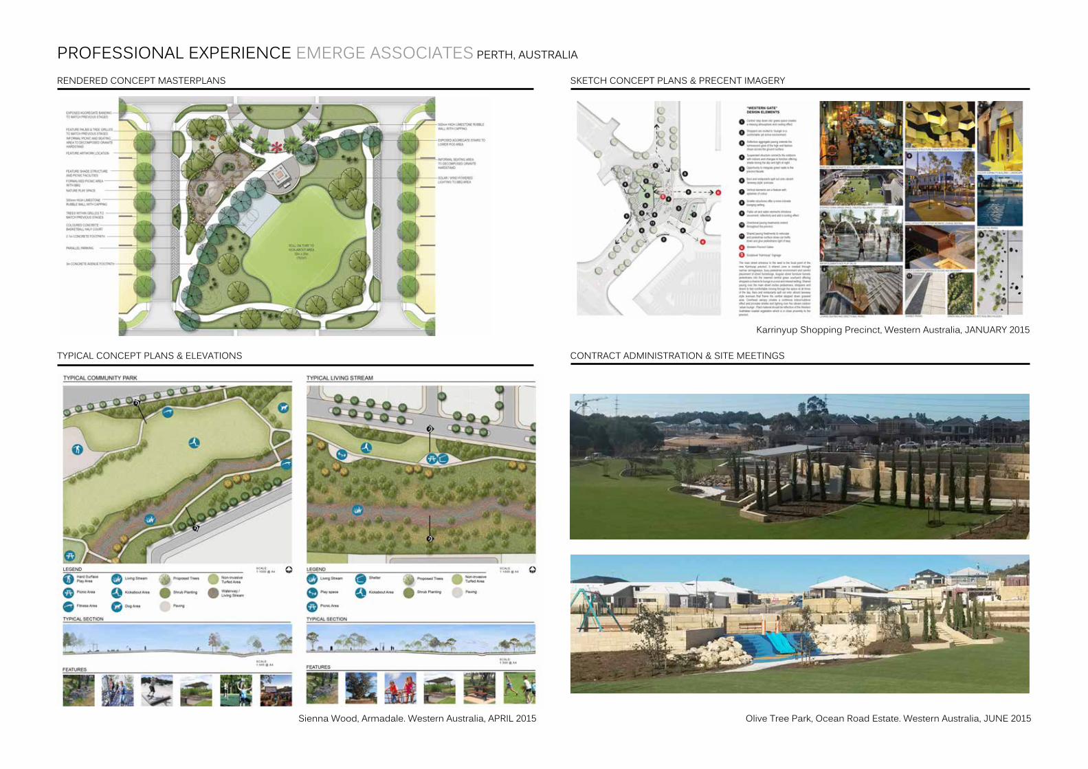
PROFESSIONAL EXPERIENCE EMERGE ASSOCIATES PERTH, AUSTRALIA
RENDERED CONCEPT MASTERPLANS SKETCH CONCEPT PLANS & PRECENT IMAGERY
CONTRACT ADMINISTRATION & SITE MEETINGSTYPICAL CONCEPT PLANS & ELEVATIONS
OliveTreePark,OceanRoadEstate.WesternAustralia,JUNE2015SiennaWood,Armadale.WesternAustralia,APRIL2015
KarrinyupShoppingPrecinct,WesternAustralia,JANUARY2015