oakland estates neighborhood plan update - san … in partnership with the oakland estates...
TRANSCRIPT

Prepared in partnership with the Oakland Estates Neighborhood Association/ Planning Team, City of San Antonio Development Services Department and the
City of San Antonio Planning & Community Development Department

April 2007 Land Use Plan Update
Oakland Estates Neighborhood Plan
111
Land Use Classification Description
TABLE OF CONTENTSTABLE OF CONTENTSTABLE OF CONTENTS OAKLAND ESTATES NEIGHBORHOOD PLAN UPDATE ACKNOWLEDGEMENTS…………………………………………………………………………………….……2 PUBLIC OUTREACH…………………………………………………………………………………………...…..3 LAND USE CATEGORIES & DESCRIPTIONS…………………………...………………………………………4 LAND USE CONCEPTS………………………………………………………….……………………………..…10 EXISTING LAND USE MAP……………………………………………………………………………………...12 LAND USE PLAN…………………………………………………………………...……………………………..13 COMMUNITY DEMOGRAPHICS……………………………………………..………………………...……….14 PLANNING COMMISSION RESOLUTION…………………………………………………...…………………16 CITY COUNCIL ORDINANCE………………………………………………………………………….………..18 OAKLAND ESTATES NEIGHBORHOOD PLAN (adopted August 31, 2000) I. INTRODUCTION TO OAKLAND ESTATES A. NEIGHBORHOOD DESCRIPTION B. HISTORY II. PURPOSE OF NEIGHBORHOOD PLAN III. ZONING AND LAND USE A. ZONING B. CODE COMPLIANCE IV. TRAFFIC AND CRIME V. STREETS AND DRAINAGE VI. SERVICES AND UTILITIES VII. APPENDIX A. PLANNING TEAM B. NEIGHBORHOOD SURVEY AND RESULTS C. ANALYSIS OF RESPONSES (see survey graphs - separate) D. SUMMARY OF SURVEY RESULTS E. MAPS F. SUPPLEMENTAL DATA

April 2007 Land Use Plan Update
Oakland Estates Neighborhood Plan
222
Land Use Classification Description CITY OFFICIALSCITY OFFICIALSCITY OFFICIALS Mayor Phil Hardberger City Council Roger O. Flores, District 1 Sheila D. McNeil, District 2 Roland Gutierrez, District 3 Richard Perez, District 4 Patti Radle, District 5 Delicia Herrera, District 6 Elena Guajardo, District 7 Art A. Hall, District 8 Kevin Wolff, District 9 Christopher “Chip” Haass, District 10 PLANNING COMMISSIONPLANNING COMMISSIONPLANNING COMMISSION Murray H. Van Eman, Chairperson Cecilia G. Garcia, Vice Chair Robert G. Hanley, Chair Pro Tem Dr. Sherry Chao John Friesenhahn Amy Hartman Jose R. Limon Dr. Francine S. Romero Ivy R. Taylor
PLANNING TEAMPLANNING TEAMPLANNING TEAM Joe Conrad Rob Grimes Ruth Heskew Kim Hoskins James Galloway-Edgar Ross Laughead Val Lawrence Roy Menchaca Sandy Miller Cliff Morton Estate Billy Pitts
Edwin Ray Anthony Salvagno Karen Shimotsu Jim Sims Sue Snyder John Solis Padmasiri Somawardana Scott Southwell Ernestine Studer Barney Tearney Russ Tracy
PLANNING STAFFPLANNING STAFFPLANNING STAFF Emil Moncivais, FAICP, AIA, CNU, Director Nina Nixon-Mendez, AICP, Manager Zenon F. Solis, Project Manager Christopher Garcia Andrea Gilles Gustavo Gutierrez Elizabeth Johnson Joe Mendoza James “Doug” Overton Steve Pease Sonia Rios Agdel Rivera Evangelina Rodriguez Patricia Wallace, AICP Christine Zuniga
TECHNICAL ADVISORSTECHNICAL ADVISORSTECHNICAL ADVISORS Santa G. Rivas SAWS, Infrastructure Planning William Thorpe Public Works Dept, Traffic Engineering Andrew Winters, PE Development Services Dept, Development Engineering Section
Robert J. Browning, PE, CFM COSA Public Works Dept,. Storm Water Engineering Rudy Niño COSA Development Services Dept., Zoning Division Richard Ramirez COSA Development Services Dept., Zoning Division

April 2007 Land Use Plan Update
Oakland Estates Neighborhood Plan
333
Land Use Classification Description PUBLIC OUTREACHPUBLIC OUTREACHPUBLIC OUTREACH
PUBLIC MEETING: • JANUARY 5, 2006 – Held by Councilman Hall, Planning & Community Development , and Devel-
opment Services explaining the plan update and zoning process PLANNING TEAM MEETINGS: • JUNE 27, 2006 (18+ in attendance) • JULY 11, 2006 (29+ in attendance) • JULY 27, 2006 (70+ in attendance) • FEBRUARY 12, 2007 (24+ in attendance) OPEN HOUSE MEETINGS: • JULY 13 , 2006 (36+ in attendance)
◊ Documents available for comment: JULY 13 through JULY 21 (72 different comment cards/emails received)
• FEBRUARY 21, 2007 (40+ in attendance)
◊ Documents available for comment: FEBRUARY 21 through FEBRUARY 26 (33 different comment cards/emails received)
PLANNING TEAM INTERVIEWS: • SEPTEMBER 6, 2007 TO SEPTEMBER 25, 2007
PLANNING COMMISSION PUBLIC HEARING: • MARCH 14, 2007 CITY COUNCIL PUBLIC HEARING: • APRIL 19, 2007

April 2007 Land Use Plan Update
Oakland Estates Neighborhood Plan
444
Land Use Classification Description LAND USE PLAN LAND USE PLAN LAND USE PLAN
The Land Use Plan builds on the goals and objectives of the Oakland Estates Neighborhood Plan and identifies the preferred land development pattern. The plan reflects, in general terms, compatible land uses and serves as a policy guide for future development. Two primary tools for implementation of the land use plan are the Unified Development Code (zoning and subdivision ordinances) and the Capital Improvements Program (CIP), the city’s six-year financial plan for capital projects. After adoption by City Council, the Planning Department will consult the Land Use Plan as a guide for developing staff recommendations on individual zoning cases.
The Plan emphasizes preserving existing single-family developments, while locating most commercial uses at nodes, or along highly traversed corridors. Commercial uses are also segregated by intensity of use, with Community Commercial uses being located primarily at the intersection of arterials, and Neighborhood Commercial uses where collectors and arterials meet, or where collectors and residential streets meet.
The Plan does not constitute zoning regulations or establish zoning district boundaries. The Related Zoning Districts in each Land Use category is meant to serve as a comparative guide to utilize when evaluating for “consistency” between development / rezoning proposals and the goals of the plan. More intense land uses may be allowed in less intense land use categories subject to conditional zoning or a specific use authorization that would facilitate context-sensitive design in accordance with the plan’s goals and objectives.
The following Land Use Plan categories and examples further explain the proposed future land uses. The cross references of Land Use Plan categories with comparable uses permitted in certain Zoning Districts as defined in the Unified Development Code is a guide for future rezonings. A Land Use Plan does not constitute zoning regulations or establish zoning district boundaries. Rather, it is a plan for the long-range development of a municipality used to coordinate and guide the establishment of development regulations (Local Government Code, Chapter 213).
The adoption of this Land Use Plan supersedes Section A. “Zoning” found in chapter III entitled “Zoning and Land Use” in the Oakland Estates Neighborhood Pan adopted on August 31, 2000.

April 2007 Land Use Plan Update
Oakland Estates Neighborhood Plan
555
Land Use Classification Description
Low Density Residential Low Density Residential Development includes Single Family Residential Development on individual lots. This form of development should be located away from major arterials, and can include certain non-residential uses such as schools, places of worship, and parks that are centrally located for convenient neighborhood access.
Light Yellow
Related Zoning Districts: R-6, NP-8, NP-10, NP-15, R-20, & * RE * Preferred for Interior Lots
Low Density Residential Estate
Residential Estate Development includes large lot Single Family Residen-tial Development which would allow an individual lot no less than 15,000 square feet. This form of development should be located away from major arterials, and can include certain non-residential uses such as schools, places of worship, and parks that are centrally located for convenient neighborhood access.
Light Yellow
Related Zoning Districts: NP-15, R-20,* RE, & RP * Preferred for Interior Lots

April 2007 Land Use Plan Update
Oakland Estates Neighborhood Plan
666
Land Use Classification Description
High Density Residential
High Density Residential Development includes multi-family developments with more than four units, such as apartment complexes, but can also in-clude low density and medium density residential uses. This form of development should be located along collectors, arterials, or highways, and can serve as a buffer between low or medium density residential land uses and commercial uses. This classification can include certain non-residential uses such as schools, places of worship, and parks that are centrally located for convenient neighborhood access.
Purple
Related Zoning Districts: R-6, NP-8, NP-10, NP-15, R-20, * RE, RM-4, RM-5, RM-6, MF-25, & MF-33 * Preferred for Interior Lots
Medium Density Residential includes Single Family Residential Develop-ment on one lot including townhomes and zero lot line configurations, du-plexes, triplexes, and fourplexes. This form of development should be located along collectors, or residential roads, and can serve as a buffer between low density residential and more intense land uses like commercial. This classification includes certain non-residential uses such as schools, places of worship, and parks that are centrally located for convenient neighborhood access.
Medium Density Residential
Pink
Related Zoning Districts: R-6, NP-8, NP-10, NP-15, R-20, * RE, RM-4, RM-5, & RM-6 * Preferred for Interior Lots

April 2007 Land Use Plan Update
Oakland Estates Neighborhood Plan
777
Land Use Classification Description
Neighborhood Commercial
Neighborhood Commercial includes less intense commercial uses with low-impact convenience, retail, or service functions. Example of uses in-clude convenience store, small insurance or doctors office, bakery, small restaurant, bookstore, antique shop, copy service, veterinarians office, or small, neighborhood sized grocery stores. Locations for Neighborhood Commercial include arterials, and collectors where they meet arterials. Neighborhood Commercial can serve as an appropriate buffer between low, medium, and high density residential uses, or between an arterial and low density residential.
Orange
Related Zoning Districts: NC, O-1, & C-1
Medium Density Mixed Use
Medium Density Mixed Use allows for a concentrated, well structured, and integrated blend of medium density residential, light retail, professional services, office, entertainment, and other land uses. The integration of uses should occur within structures, as well as across the site, with commercial uses situated primarily along the higher order roadways, and on the ground floor level of individual structures. Medium Density Mixed Use is preferred along arterials, or in a nodal pat-tern with proximity to a major transit stop or node. When placed along a higher order roadway, the mixed use development should decrease in den-sity with distance from the roadway.
Light Brown
Related Zoning Districts: R-6, NP-8, NP-10, NP-15, R-20, RE, RM-4, RM-5, RM-6, NC, O-1, & C-1 (except C-2, C-3 & MF Zoning Districts)

April 2007 Land Use Plan Update
Oakland Estates Neighborhood Plan
888
Land Use Classification Description
Community Commercial
Community Commercial provides for offices, professional services, and retail uses of moderate intensity and impact. Example of uses include a grocery store, a medical office, music store, shoe store, nursery, or mailing services store. Locations for Community Commercial include along arterials. Community Commercial can serve as an appropriate buffer between low, medium, and high density residential uses, or between an arterial and low density residential.
Bright Red
Related Zoning Districts: NC, O-1, C-1, & C-2 (except C-3 & O-2)
Regional Commercial Regional Commercial provides for offices, professional services, and retail uses that draw on the customer base of a region. Example of uses in-clude “big box” retail and retail “power centers”, shopping malls, movie theaters, and medical or office complexes that are mid to high rise. Regional Commercial uses are typically located at nodes formed by high-ways and major arterials, or two major arterials, and are usually 20 acres or greater in size. Regional Commercial uses can serve as an appropriate buffer between an arterial or highway, and lower intensity commercial or residential uses.
Maroon
Related Zoning Districts: NC, O-1, O-2, C-1, C-2, & C-3

April 2007 Land Use Plan Update
Oakland Estates Neighborhood Plan
999
Land Use Classification Description
Public Institutional Public Institutional uses include public, quasi-public, and institutional uses that facilitate the containment or delivery of local, state, or national govern-mental or non-profit services. Examples include post offices, libraries, schools, fire stations, churches, community gathering facilities, etc. The location for these services include where they currently reside, as well as where they meet the future needs of the community.
Light Blue
Parks / Open Space Parks / Open Space includes large, or linear, unimproved land where con-servation is promoted and development is not encouraged due to presence of topographic constraints or institutional uses on the site. Parks /Open Space include flood plains, utility corridors, public and private land uses that encourage outdoor passive or active recreation. Examples include City pocket, regional, or linear parks, as well as private parks associated with subdivisions and neighborhood associations.
Green

April 2007 Land Use Plan Update
Oakland Estates Neighborhood Plan
101010
Land Use Classification Description LAND USE CONCEPTSLAND USE CONCEPTSLAND USE CONCEPTS
Oakland Estates, which has historically been a single family estate subdivision with a rural ambience, is a neighborhood that has been impacted by adjacent urban development as the city has grown the last 30 years. Bounded by major arterials, this neighborhood is unlike other recent residential neighborhoods. The residential subdivisions adjacent to Oakland Estates exhibit a suburban development pattern and are oriented to the interior of the residential development, front local residential roads, and often have pe-rimeter walls along the arterial roadway as a buffer. However, with the historic 1926 development pat-tern of Oakland Estates, the exterior lots along the major arterials (Babcock, Huebner and Prue Roads) are oriented to the exterior of the neighborhood and face the arterial roadway. The orientation of the lots to heavily traveled arterial roads and the lack of a local residential street to serve the residential develop-ment of these lots limit the residential use of the property. The intent of the land use plan is to provide an objective land use approach that respects the historic neighborhood patterns, while responding to the ad-jacent urban growth patterns.
Babcock and Prue Road Land Use Patterns Low Density Residential Estate Land uses consisting of single family residences are preferred for the in-terior lots and Babcock Road properties. Low Density Residential land uses are preferred for the proper-ties along Prue Road. Gated communities are discouraged.
Huebner Road Land Uses Community Commercial land uses are recommended along Huebner Road spanning from Babcock to Southwell Roads. Community Commercial uses, that draw their customer base from the larger commu-nity, are developed as nodes on arterials at major intersections, or in established commercial areas along arterials. Community Commercial uses should incorporate well-defined and accessible trees in parking lots, and landscaping on planter strips between the parking lot and the street. To discourage large areas devoted to parking lots, shared parking facilities and pervious pavement are encouraged. Ingress and egress on interior streets should be prohibited through covenants to protect the single-family estate resi-dential character. Land Uses for triangular area bound by Prue Road, Prue Road Extension, Huebner Road and Southwell Road Southwell Road is a local street of the Oakland Estates neighborhood. The proposed land use allows a more intense residential and commercial development based on the establishment of an agreement to pro-hibit access to Southwell Road, and supporting shared internal access to the Prue Road Extension. If non-access to Southwell Road is not established, land uses between Southwell Road and the eastern 1926 Plat boundary should be low density residential. This pattern would encourage a wall along Southwell Road. Medium Density Mixed Use would occur until the 1926 Plat boundary, and a more intense Com-munity Commercial land use would be permitted from the Plat boundary to the Prue Rd. Extension. Me-dium Density Mixed Use would incorporate medium density residential uses such as townhomes, zero lot line configurations, duplexes, triplexes and fourplexes, in addition to Single Family residential. Commu-nity Commercial use would continue to extend from the Prue Rd. Extension to Fredericksburg Road.

April 2007 Land Use Plan Update
Oakland Estates Neighborhood Plan
111111
Land Use Classification Description LAND USE CONCEPTS LAND USE CONCEPTS LAND USE CONCEPTS
Medium Density Mixed Use includes:
· Single Family Residential not to exceed 7 du/acre (R-6 would be smallest zoning category) · Single Family Residential Estates (NP-8, NP-10, NP-15, R-20, RE) · Residential Mixed Districts (RM-4, RM-5, RM-6) · Neighborhood Commercial District (NC), Office District (O-1) · Light Commercial District (C-1)
Institutional Uses Several religious institutions are located throughout the neighborhood. These are currently designated as Public/Institutional land use; however, it is preferred that if these uses become vacated, that the use revert back to Low Density Residential
Disclaimer for maps: This Geographic Information System Product, received from The City of San Antonio is provided "as is" without warranty of any kind, and the City of San Antonio expressly disclaims all expressed and implied warranties, in-cluding but not limited to the implied warranties of merchantability and fitness for a particular purpose. The City of San Antonio does not warrant, guarantee, or make any representations regarding the use, or the results of the use, of the information provided to you by the City of San Antonio in terms of correctness, accuracy, reliability, timeliness or otherwise. The entire risk as to the results and performance of any information obtained from the City of San Antonio is en-tirely assumed by the recipient.
April 2007 Land Use Plan Update
Oakland Estates Neighborhood Plan
121212
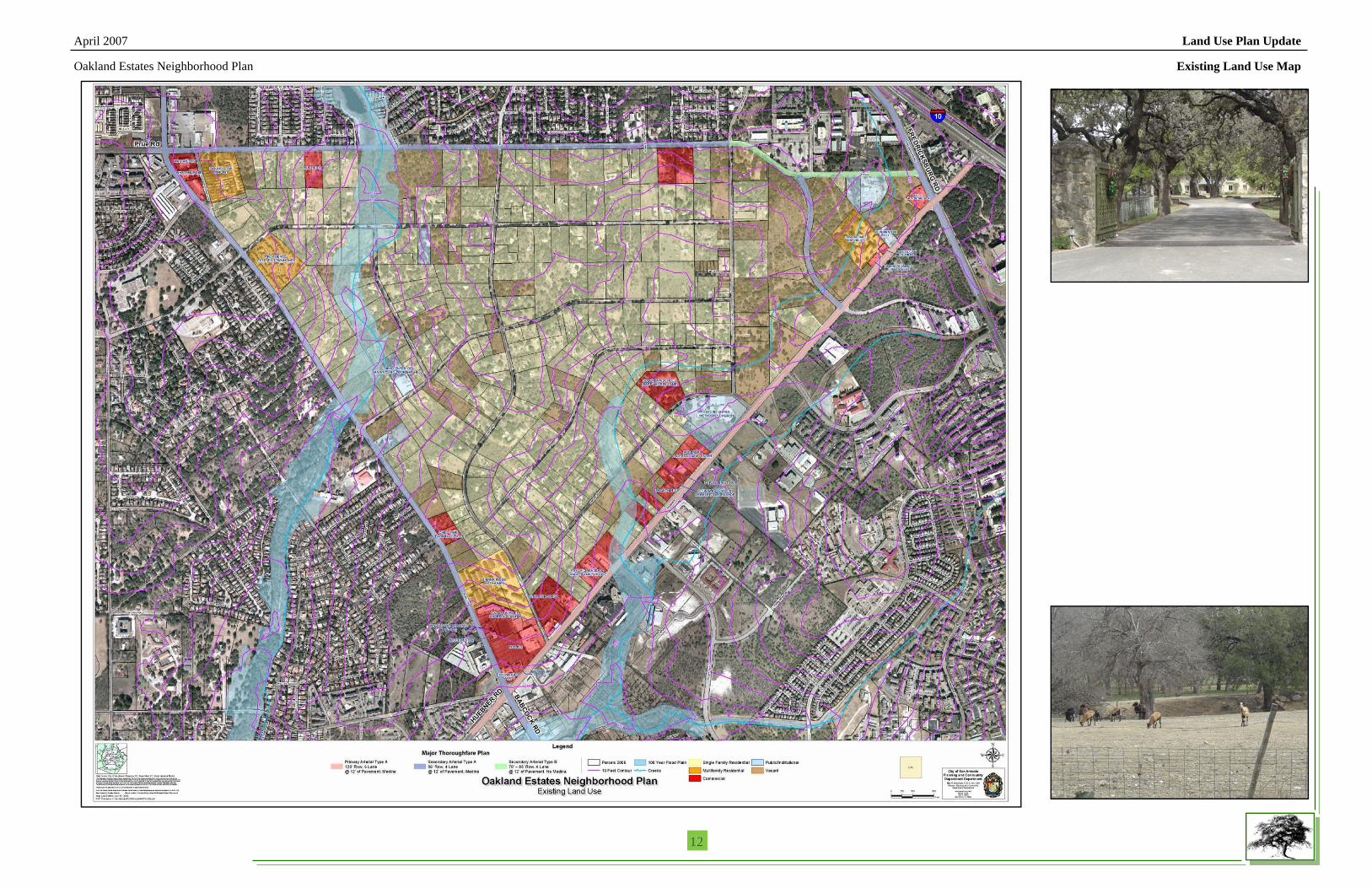
Existing Land Use Map

April 2007 Land Use Plan Update
Oakland Estates Neighborhood Plan
131313
Land Use Plan

April 2007 Land Use Plan Update
Oakland Estates Neighborhood Plan
141414
Land Use Classification Description Community Demographics The following tables provide population and housing demographics for the Oakland Estates Neighbor-hood Plan and the City as a whole. The Community was defined by following census tract block groups: 1980, 1990, & 2000 Census for population and housing, data based on SF-1 & SF-3 data files. The geo-graphic area includes 1818.021 for 1980 & 1990 and 1818.081 for 2000. This information was presented during the planning process to update the land use plan.
Oakland Estates Neighborhood Plan Demographics

April 2007 Land Use Plan Update
Oakland Estates Neighborhood Plan
151515
Land Use Classification Description Oakland Estates Neighborhood Plan Demographics

April 2007 Land Use Plan Update
Oakland Estates Neighborhood Plan
161616
Land Use Classification Description

Please see the Future Land Use Plan Map on page 13.
For a copy of the Future Land Use Plan Map recommended by the Planning Commission, contact the Department of Planning and Community Development.

SG 4-19-07 Master Plan Amendment Item No. P-1 AMENDED CO Oakland Estates Neighborhood Plan
ip8 - AN ORDINANCE
ADOPTING THE OAKLAND ESTATES NEIGHBORHOOD PLAN UPDATE AS A COMPONENT OF THE MASTER PLAN OF THE CITY FOR AN AREA COVERING APPROXIMATELY 937 ACRES OF LAND BOUND BY PRUE ROAD TO THE NORTH, FREDERICKSBURG ROAD TO THE EAST, HUEBNER ROAD TO THE SOUTH, AND BABCOCK ROAD TO THE WEST; SUPERSEDING THE LAND USE ELEMENT IN THE OAKLAND ESTATES NEIGHBORHOOD PLAN ADOPTED AUGUST 31,2000.
* * * * *
WHEREAS, the Oakland Estates Neighborhood Plan was adopted by the City Council on August 3 1,2000, and
WHEREAS, according to 535-420 of the UnlJied Development Code, the Neighborhood Plan shall be reviewed by Planning Commission at least once every five years, and
WHEREAS, the Oakland Estates Neighborhood includes approximately 937 acres and per the 2000 census, has a population of approximately 1,073 people and is bound by Prue Road to the north, Fredericksburg to the east, Huebner Road to the south, and Babcock Road to the west; and
WHEREAS, the San Antonio Planning Commission reviewed the Oakland Estates Neighborhood Plan Update on March 14, 2007 and found the plan to be consistent with City policies, plans and regulations and in conformance with the Unzfied Development Code, 535-420, therefore meeting all requirements; NOW THEREFORE:
BE IT ORDAINED BY THE CITY COUNCIL OF THE CITY OF SAN ANTONIO:
SECTION 1. The Oakland Estates Neighborhood Plan Update is hereby amended to update the land use element as a component of the City’s Master Plan as it conforms to the approval criteria set forth in the Unzfied Development Code, 535-420, pertaining to “comprehensive, neighborhood, community, and perimeter plans” and superseding the land use element of the Oakland Estates Neighborhood Plan Update adopted August 3 1, 2000 (Ord. No. 92440). A copy of the plan is attached hereto and incorporated by reference as Attachment I.
SECTION 2. No funds will be expended by this ordinance.

SG 4-19-07 Item No. P-1 AMENDED CORRECTED
Master Plan Amendment Oakland Estates Neighborhood Plan
SECTION 3. This ordinance shall take effect April 29,2007.
PASSED AND APPROVED on this 19'h da
ATTEST:
h
APPROVED AS TO FORM: , City Attorney
62/
2