p5.1 new science for the wsr-88d: …p5.1 new science for the wsr-88d: staggered prt implementation...
TRANSCRIPT
P5.1 NEW SCIENCE FOR THE WSR-88D: STAGGERED PRT IMPLEMENTATION ON THE VAISALA/SIGMET RVP8.
Darcy Saxion
NOAA/NEXRAD Radar Operations Center, Norman, OK
David Zittel, Olen Boydstun NOAA/NEXRAD Radar Operations Center, Norman, OK
Rick Rhoton, Rich Ice, Jane Krause
Wyle Information Systems, Norman, OK
Sebastián Torres, David Warde
Cooperative Institute for Mesoscale Meteorological Studies, The University of Oklahoma and NOAA/OAR National Severe Storms Laboratory, Norman, OK
1. INTRODUCTION
One of the responsibilities of the Radar Operations Center (ROC) is to provide the best data quality of the base moments (reflectivity, velocity, and spectrum width) given the current technology of the WSR-88D. Improving the data quality includes reducing velocity aliasing, recovering range folded signals, removing contamination from normally and anomalously propagated ground clutter, and increasing resolution. These improvements can be performed in one of two parts of the WSR-88D system; early in the system in the Open Radar Data Acquisition where signal processing can be applied to the Level I data (time series), or later in the system in the Radar Product Generator (RPG) where algorithms can be applied to the Level II data (base moments). The ROC is able to implement new signal processing algorithms as ‘major modes’ on the Vaisala/SIGMET RVP8 as part of the Open Radar Data Acquisition (ORDA) subsystem of the WSR-88D (Saxion 2007). The ROC has successfully deployed a new major mode that executes the Sachidananda/Zrnić Phase Coding algorithm (SZ-2) which mitigates range folding. Now the ROC is implementing as a major mode the Staggered Pulse Repetition Time (SPRT) algorithm developed at the National Severe Storms Laboratory (NSSL) to mitigate velocity aliasing.
Instead of transmitting pulses at a uniform pulse repetition time (PRT), the SPRT technique transmits pulses using alternating PRTs at a known PRT ratio. It calculates a velocity from each PRT using lag-1 autocorrelations. Then it uses a velocity difference transfer function to recover velocities beyond the unambiguous velocity for either of the original PRTs. (Sirmans 1976). The NSSL improved the algorithm by defining generalized dealiasing rules that work with any PRT ratio (Torres 2004). The NSSL also adapted the
Corresponding author address: Darcy Saxion, NWS/ROC, 1313 Halley Circle, Norman OK, 73069; email: [email protected] The views expressed are those of the authors and do not necessarily represent those of NOAA’s National Weather Service.
algorithm to mesh well with the existing RVP8 architecture (Torres 2009b)
Ground clutter is one of the bigger contaminants of weather data. Effective ground clutter filtering is a must for the operational environment. Until recently, effective ground clutter filters worked only with time series data from uniform PRTs. The only clutter filter that worked with SPRT’s non-uniform PRTs was a simple and less effective DC removal filter. In response to the lack of a clutter filter for the non-uniform transmission scheme, the NSSL developed the Spectral Algorithm for Clutter Harmonics Identification (SACHI) filter. Because clutter filtering is intrinsic to providing good data quality, the SACHI filter makes SPRT a viable velocity dealiasing method for the WSR-88D (Torres 2009b).
2. THE THREE PHASED APPROACH TO SPRT
The ROC is implementing SPRT in three phases. The first phase was completed in August 2007. Several things were accomplished during Phase I. First, after the approval of the NEXRAD tri-agencies, the ROC decided to implement the SPRT algorithm provided by the NSSL. Second, the ROC enabled the ability to transmit using an SPRT scheme. And finally, the ROC collected SPRT time series data to use for testing during implementation. Most of the Phase II was completed in February 2009. It consisted of implementing SPRT with the DC removal clutter filter for continued engineering testing, culminating in a bin-by-bin comparison of the ROC’s RVP8 implementation with the NSSL’s MATLAB implementation. During Phase II, the NSSL formalized the SACHI filter and delivered it to the ROC. Also, the ROC Applications Branch adjusted the RPG’s Velocity Dealiasing Algorithm to mitigate SPRT ‘catastrophic’ dealiasing errors (Torres, 2009a). The portion of Phase II SPRT yet to be completed is an engineering analysis of the base moments. Phase III of the SPRT development is comprised of implementing the SACHI clutter filter, analyzing SACHI filtered base moments, providing operational functionality and demonstrating data quality. Providing operational functionality includes defining an operational Volume Coverage Pattern (VCP) with PRT selections that optimize the performance of SPRT and the SACHI filter.

At the beginning of Phase III, the ROC was faced with two tasks: define an operational VCP and determine how to approach the engineering analysis. To do this, the ROC formed the SPRT working group (SWG) that is comprised of ROC Software software engineers, ROC systems engineers, ROC Applications Branch meteorologists, and NSSL scientists. The mission of the SWG is to provide guidance and recommendations to the ROC and NEXRAD tri-agencies regarding SPRT implementation. The SWG decided to make a first attempt at an operational VCP then modify it to aid with the engineering analysis. We ended up with engineering VCP 223.
3. VCP OVERVIEW
Before continuing to discuss the development of the SPRT VCP, it is helpful to review how the VCP definition affects the operation of the radar and the signal processing environment. When providing new signal processing algorithms via a major mode, the method by which the algorithm is executed is the VCP definition. Each cut, or elevation scan, has an associated signal processing technique. Take VCP 221, for example (see Figure 1). The lowest two elevations, 0.5º and 1.45º, have split-cut processing using SZ-2 mode processing. Scans at elevation angles 2.4, 3.4, 4.3 and 6.0 degrees use batch mode processing. And, finally, scans at elevations 9.9, 14.6, and 19.5 degrees use contiguous Doppler mode processing.
Another important parameter that the VCP definition specifies is the rotation rate for each elevation scan. This defines the speed of rotation of the antenna and determines how many seconds each scan takes to complete. The sum of the time for each scan for all the scans (plus a small amount of additional time for retracing) gives the total time needed for the VCP to update. For VCP 221, the update time is 5.75 minutes.
The final parameter that needs to be considered is the PRT which is the time between the transmitted pulses. Since PRT affects range folding, velocity aliasing, and the number of samples per range bin, it plays a critical role in the quality of the estimates of the base moments. Again, let’s look at VCP 221. On the first scan at 0.5º of elevation, the PRT is long, allowing for sampling the atmosphere at long ranges, but the maximum unambiguous velocity is very small, thus the velocities tend to alias. The second scan at 0.5º of elevation uses a short PRT. This provides a high maximum unambiguous velocity, but a short maximum range. At this low elevation angle, the short PRT will very often have range folded echoes, or signals from beyond the maximum range overlaid onto the signal within the maximum range. Clearly, range folding and velocity aliasing degrades data quality. One method to mitigate these problems is to introduce new signal processing techniques that correct them. In VCP 221, on the elevation scan at 0.5º, the VCP uses the SZ-2 major mode to greatly reduce the amount of range folding seen on the second scan with the short PRT. This allows for the use of shorter PRTs which provide higher unambiguous velocities.
4. ENGINEERING VCP 223
When creating an operational VCP, the SWG had a number of constraints to consider. First, the SWG needed to determine if it would add a new VCP to the operational suite of VCPs or modify an existing VCP. The final decision for this is still outstanding, however, since the number of VCPs has grown in recent years (in part because of the addition of the range-velocity mitigation VCPs). The SWG took the approach of modifying an existing VCP. We began by looking at other range-velocity VCPs. First, we looked VCP 121, the range-velocity mitigation VCP using Multi-PRF Dealiasing Algorithm (MPDA) (Zittel 2005) because SPRT could reduce the number of scans MPDA needed. However, since SPRT is a range-velocity mitigation technique best suited for upper tilts of a VCP (because of higher wind speeds and smaller coverage in range resulting in faster update times and less range folding), we decided to combine it with the SZ-2 range folding mitigation technique that is suited for lower tilts. We chose to work with VCP 221 since its rotation rates matched SPRT needs. The first task was to determine which of the batch and contiguous Doppler scans we could replace with SPRT.
Distance from Radar (nm)
Hei
ght
Abo
ve R
ada
r L
eve
l (kf
t)
Range vs. Height from WSR-88D Beam Height Equation VCP 221
0.5º
1.45º
2.4º
3.4º4.3º6.0º9.9º14.6º19.5º
Distance from Radar (nm)
Hei
ght
Abo
ve R
ada
r L
eve
l (kf
t)
Range vs. Height from WSR-88D Beam Height Equation VCP 221
0.5º
1.45º
2.4º
3.4º4.3º6.0º9.9º14.6º19.5º
Fig. 1. VCP 221. Blue: SZ-2 processing,
Red: Batch mode processing, Green: Contiguous Doppler processing.
Two other constraints that the SWG considered
when defining an operational VCP were the update time and the impact on data quality. The meteorological community needs update times as fast as possible to be able to closely track storm development. However, methods to improve data quality perform best with higher numbers of samples and slower rotation rates (thus, slower update times). When determining which elevation angles would benefit by using SPRT processing, the SWG needed to carefully weigh the improvement in recovered velocities, the range covered by the scan, and the effects of different PRTs on the update time of the scan.
The NSSL had provided recommendations of PRTs yielding optimal performance for SPRT with the SACHI
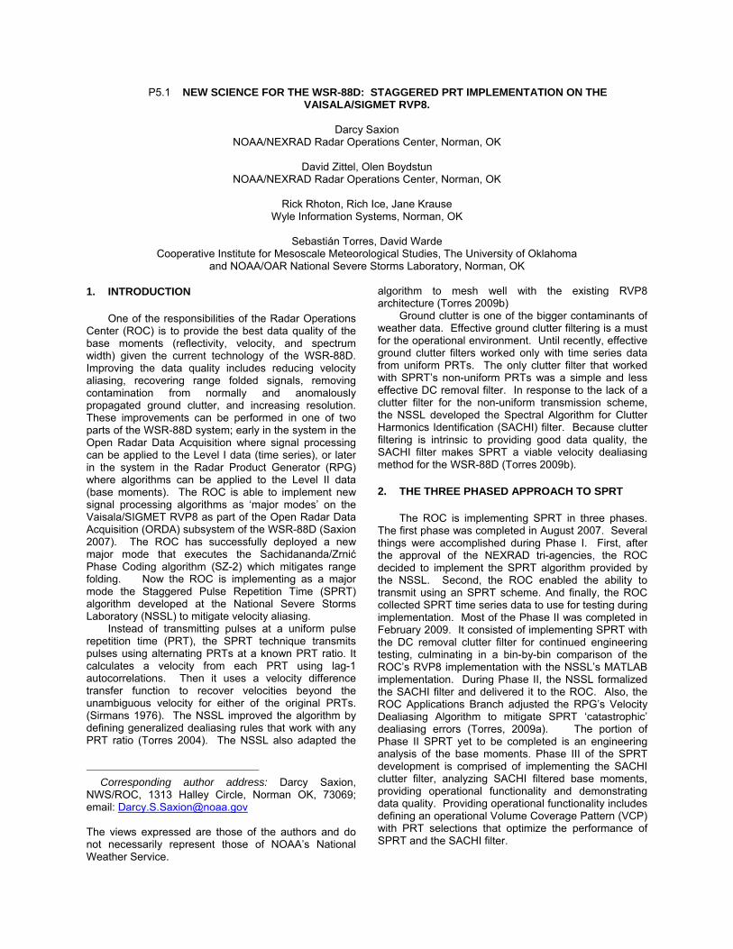
filter at different elevation angles. Using this knowledge, the SWG carefully looked at VCP 221. The upper tilts are limited in range because they quickly reach the 70kft storm top limit. At elevations at and above 4.3º, it was straightforward to get the range coverage needed along with the significant improvement in maximum unambiguous velocity. The difficulty in determining optimal performance vs. minimal update time was at the lower elevations, 2.4º and 3.4º, which are scans that required a larger coverage in range and more clutter filtering. We chose the shortest possible PRT giving the best coverage coupled with a rotation rate that provided an adequate number of samples and kept the update time of the VCP the same as the update time of VCP 221. It is these middle tilts that especially benefit from engineering analysis. After making these modifications to VCP 221, the SWG had a draft of a possible operational VCP. For the sake of clarity during the engineering process, we named it VCP 222, (Figure 2). The next step is to determine if this draft VCP could be acceptable as an operational VCP.
Distance from Radar (nm)
He
igh
t A
bove
Rad
ar
Lev
el (
kft)
Range vs. Height from WSR-88D Beam Height Equation VCP 222
0.5º
1.45º
2.4º
3.4º4.3º6.0º9.9º14.6º19.5º
Distance from Radar (nm)
He
igh
t A
bove
Rad
ar
Lev
el (
kft)
Range vs. Height from WSR-88D Beam Height Equation VCP 222
0.5º
1.45º
2.4º
3.4º4.3º6.0º9.9º14.6º19.5º
Fig. 2 VCP 222 Blue: SZ-2 processing,
Black: SPRT processing.
To determine if VCP 222 would be a viable operational VCP, the SWG needed a way to compare it with the current operational VCP, VCP 221. Running VCP 221, then running VCP 222 would create too much of a time difference between scans at the same elevation angle, making the comparison between the two different types of processing inaccurate. The SWG decided to create an engineering test VCP by combining VCP 222 and VCP 221. The engineering VCP, referred to as VCP 223, provides multiple scans using different signal processing techniques at the same elevation angles to allow for an accurate comparison.
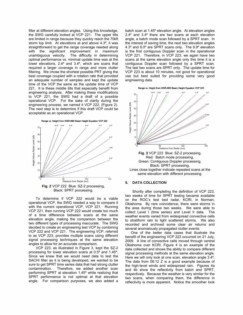
VCP 223, as illustrated in Figure 3, kept the SZ-2 processing for lower elevation scans at 0.5º and 1.45º. Since we knew that we would need data to test the SACHI filter as it is being developed, we wanted to be sure to get SPRT time series data that had strong clutter contamination. Therefore, we added another scan performing SPRT at elevation 1.45º while realizing that SPRT performance is not optimal at that elevation angle. For comparison purposes, we also added a
batch scan at 1.45º elevation angle. At elevation angles 2.4º and 3.4º there are two scans at each elevation angle, a batch mode scan followed by a SPRT scan. In the interest of saving time, the next two elevation angles 4.3º and 6.0º are SPRT scans only. The 9.9º elevation is the first contiguous Doppler scan in the operational VCP 221. Therefore, in VCP 223, we again have two scans at the same elevation angle only this time it is a contiguous Doppler scan followed by a SPRT scan. The last two scans are SPRT only. The update time for VCP 223 is about 10 minutes, not good for operational use but best suited for providing some very good engineering data.
Distance from Radar (nm)
Hei
ght
Abo
ve R
adar
Lev
el (
kft)
Range vs. Height from WSR-88D Beam Height Equation VCP 223
0.5º
1.45º
2.4º
3.4º4.3º6.0º9.9º14.6º19.5º
Distance from Radar (nm)
Hei
ght
Abo
ve R
adar
Lev
el (
kft)
Range vs. Height from WSR-88D Beam Height Equation VCP 223
0.5º
1.45º
2.4º
3.4º4.3º6.0º9.9º14.6º19.5º
Fig. 3 VCP 223 Blue: SZ-2 processing,
Red: Batch mode processing, Green: Contiguous Doppler processing,
Black: SPRT processing. Lines close together indicate repeated scans at the
same elevation with different processing.
5. DATA COLLECTION
Shortly after completing the definition of VCP 223, two weeks of time for SPRT testing became available on the ROC’s test bed radar, KCRI, in Norman, Oklahoma. By rare coincidence, there were storms in the area during those two weeks. We were able to collect Level I (time series) and Level II data. The weather events varied from widespread convective cells to stratiform rain to light scattered storms. We also recorded and archived some clear air returns and several anomalously propagated clutter events.
One of the better data cases that illustrate the benefit of the engineering VCP 223 occurred on 21 July, 2009. A line of convective cells moved through central Oklahoma over KCRI. Figure 4 is an example of the data collected and shows the ability to compare different signal processing methods at the same elevation angle. Here we will only look at one scan, elevation angle 3.4º. The data from 06:12 Z is a good example because of the high-level winds and widespread rain. Figures 4a and 4b show the reflectivity from batch and SPRT, respectively. Because the weather is very similar for the two scans, when comparing them, the difference in reflectivity is more apparent. Notice the smoother look

to the SPRT data. This is because of lower errors of estimates since SPRT has more samples than the fewer number of long PRT samples used to generate the batch cut reflectivity. Figures 4c and 4d shows the velocity from batch and SPRT, respectively. Notice the reduction in obscured data due to range folding (flagged by purple). The SPRT processed cut has almost no obscured data (very little purple). In figure 4c, there is an area of outgoing (red) velocities in the field of incoming (green) velocities in the northwest quadrant of the batch mode scan. Since SPRT provides a higher unambiguous velocity, the velocities are not aliased on the SPRT scan, as seen in figure 4d. None of the velocity images have had the RPG’s Velocity Dealiasing Algorithm (VDA) applied to clearly show SPRT’s performance. The VDA will still be needed to dealias the occasion when SPRT dealiasing fails and aliasing that will occur when the velocity of the upper level winds exceed the SPRT unambiguous velocity.
6. CONCLUSIONS
The ROC is proceeding through the three phases of implementing SPRT with the goal of having SPRT operational in 2012. At the junction of Phase II and Phase III, the need for Level I and Level II data for playback and analysis became apparent. The SWG built upon a proposed operational VCP, VCP 222, to develop a valuable engineering VCP, VCP 223. We had the good fortune to collect and archive a significant amount of precipitation data using VCP 223. This data will be use for future work including both engineering and meteorological analysis. The meteorological analysis examines the coverage, structure, and texture of the base moments while the engineering analysis verifies that the SPRT data meets requirements and provides an improvement in data quality over existing signal processing methods. This data provides a means to compare the operational performance of batch mode processing to the proposed improvements of SPRT processing. The analysis to be performed on this data will ensure that the data quality that the WSR-88D provides to the meteorological community is the best possible.
REFERENCES
Saxion, D., R. Rhoton, R. Ice, G. McGehee, D. Warde, O. Boydstun, W. Zittel, S. Torres, G. Meymaris, 2007: New Science for the WSR-88D. Implementing a Major Mode on the SIGMET RVP8. Preprints, 23rd International Conf. on IIPS, San Antonio, TX, Amer. Meteor. Soc., Paper P2.9.
Sirmans, D., D. Zrnić, and B. Bumgarner, 1976: Extension of maximum unambiguous Doppler velocity by use of two sampling rates. Preprints, 17th Conf. on Radar Meteorology, Seattle, WA, Amer. Meteor. Soc., 23-28.
Torres, S., D. Zittel, D. Saxion, 2009a: Update on Deployment of Staggered PRT for the NEXRAD Network. Preprints, 25th International Conf. on
IIPS, Phoenix, AZ, Amer. Meteor. Soc., Paper 11B.2.
——, and D. Warde, and D. Zrnić, 2009b: Signeal design and processing techniques for the WSR-88D ambiguity resolution―SPRT updates and generalized phase codes. National Severe Storms Laboratory Rep. Part 12, May 2009, pp. 155.
Torres, S. M., Y. F. Dubel, and D. S. Zrnić, 2004: Design, implementation, and demonstration of a staggered PRT algorithm for the WSR-88D, J. Atmos. Oceanic Technol., 21, 1389-1399.
Zittel, W.D., and T. Wiegman, 2005: VCP 121 and the multi-PRF dealiasing algorithm. NEXRAD Now, 14, 9-15.
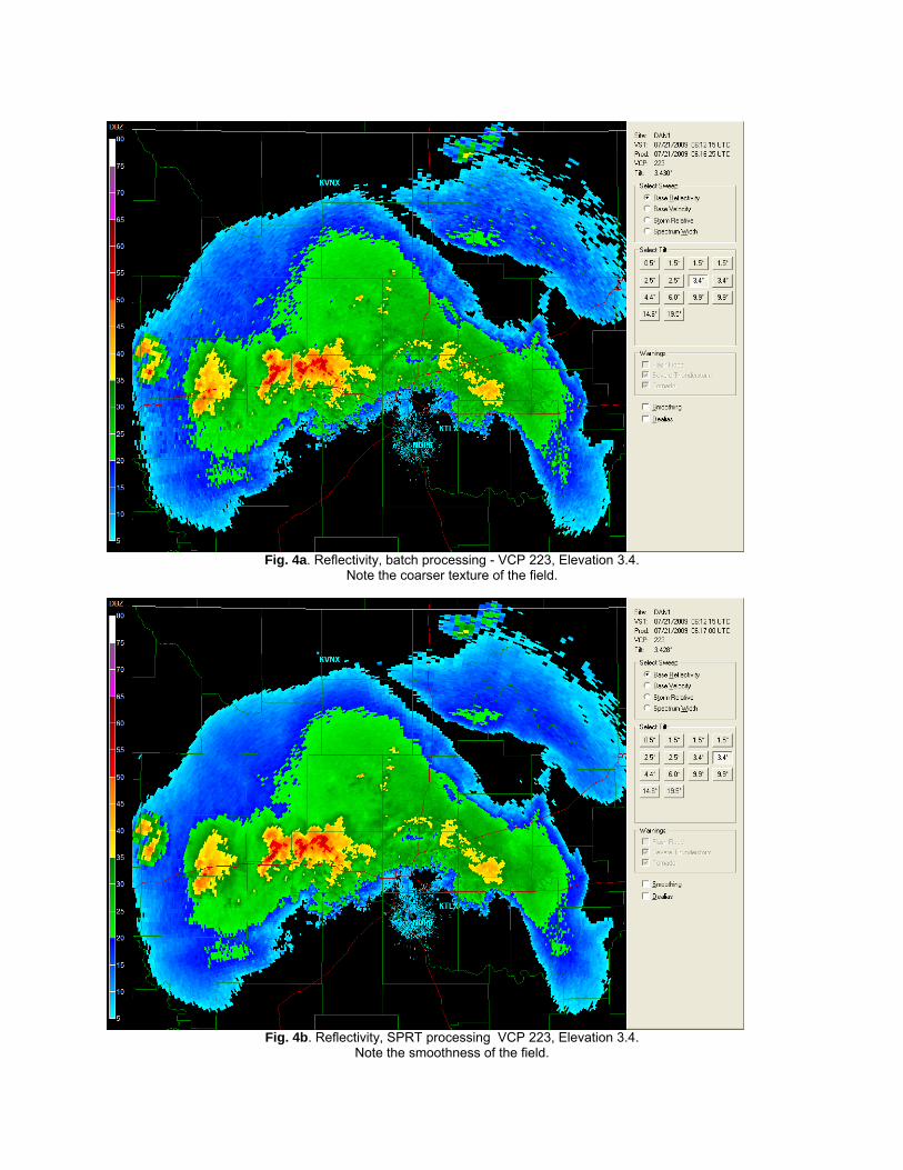
Fig. 4a. Reflectivity, batch processing - VCP 223, Elevation 3.4.
Note the coarser texture of the field.
Fig. 4b. Reflectivity, SPRT processing VCP 223, Elevation 3.4.
Note the smoothness of the field.
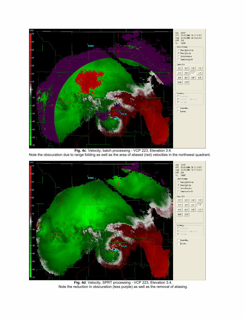
Fig. 4c. Velocity, batch processing - VCP 223, Elevation 3.4.
Note the obscuration due to range folding as well as the area of aliased (red) velocities in the northwest quadrant.
Fig. 4d. Velocity, SPRT processing - VCP 223, Elevation 3.4.
Note the reduction in obscuration (less purple) as well as the removal of aliasing.