tec c victoria, british 1988 - british...
TRANSCRIPT

I I I I I
r PROVINCE OF BRITISH COLUMBIA MI N I STRY OF E N V I RONMENT WATER MANAGEMENT BRANCH
I I I
'h.
I
I I I
i
Y
CONSTRUCTION AND TESTING OF OBSERVATION WELL NO. 296
MERRITT, BRITISH COLUMBIA
CONTRACT NO. 84
D. Kalyn Tec h n i c i an
Groundwater Sect ion
Victoria, British Columbia December 1988

II ‘ I
I I I 1 I 1 1 1 I I I I I I I I I
TABLE OF CONTENTS
1. INTRODUCTION
2. WELL CONSTRUCTION
3. WELL TESTING
4. WATER QUALITY
5. HYDROGEOLOGY
6. CONCLUSIONS AND RECOMMENDATIONS
7. REFERENCES
LIST OF FIGURES
F igu re 1 Locat ion Map
F i g u r e 2 & 3 S i t e P l a n
F i g u r e 4 We1 1 Construct ion D e t a i l s
F igu re 5 & 6 S u r f i c i a l Geology
PAGE
1
-
2
3
4
6
8
9
10
11,12
13
14,15
LIST OF APPENDICES
Appendix A Well Log, Contract Cost, Sieve Analysis 16
Appendix B Pump Test Data 22
Appendix C Water Qual i t y Lab Analyses 29
Appendix D Water Level Recorder I n s t a l 1 a t i o n S p e c i f i c a t i o n s 40
Appendix E Photographs 43
I 1 I I E I I E I I I I I I 0 I II
- 1 -
INTRODUCTION
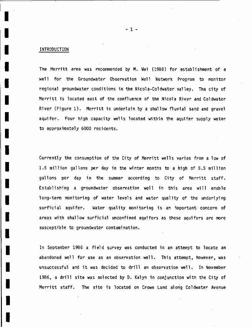
The Merritt area was recommended by M. Wei (1986) f o r establishment of a
well f o r the Groundwater Observation Well Network Program to monitor
regional groundwater conditions i n the Nicol a-Col dwater Val ley. The c i t y of
Merritt i s located e a s t of the confluence of the Nicola River and Coldwater
River (Figure 1). Merritt i s underlain by a shallow fluvial sand and gravel
aquifer. Four h i g h capacity wells located w i t h i n the aquifer supply water
t o approximately 6000 residents.
Currently the consumption of the City of Merritt wells varies from a low of
1.5 mill ion gallons per day i n the winter months to a high of 5.5 mill ion
gallons per day i n the summer according to City of Merritt s t a f f .
Establishing a groundwater observation well i n this area will enable
long-term monitoring of water levels and water quali ty of the underlying
surfici a1 aqui fer. Water qual i t y monitoring is an important.. concern of
areas w i t h shallow surf ic ia l unconfined aquifers a s these aquifers are more
susceptible to groundwater contamination.
In September 1986 a f ie ld survey was conducted i n an attempt to locate an
abandoned well f o r use as an observation well. T h i s attempt, however, was
unsuccessful and i t was decided t o d r i l l an observation well. In November
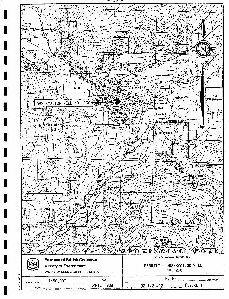
1986, a d r i l l s i t e was selected by D. Kalyn i n conjunction w i t h the City of
Merritt s t a f f . The s i te is located on Crown Land along Coldwater Avenue

I I I I I I I I I 1 I I I I E I I 1 n
- 2 -
(F igu res 2 and 3 ) and i s c u r r e n t l y used as a recrea t ion l o t by the Minis t ry
o f Fores t s and Lands. An agreement w i t h B.C. Building Corporat ion was
obtained i n o rder to allow the d r i l l i n g of an observat ion well on this l o t
and t o allow monitoring of the well f o r a m i n i m u m 10 year period.
WELL CONSTRUCTION
D r i l l i n g and t e s t i n g was c a r r i e d out by M. Schib l i Water Wells of Lumby,
British Columbia, under Government Contract No. 84. Construct ion of the
well took place on March 2 t o 5 , 1987, and t o t a l c o n t r a c t c o s t s were
$4,462.82. These c o s t s a r e itemized and shown i n Appendix A. The 152mm
diameter well was d r i l l e d by the a i r ro ta ry method t o a depth of 17 metres
Well cons t ruc t ion d e t a i l s a r e i l l u s t r a t e d i n Figure 4. Due to boulders near
ground level, no s u r f a c e casing was i n s t a l l e d i n this well. D r i l l i n g
encountered the f o l l owi ng mater i a1 s: 7-
0 - 0.3m Top Soil
0.3m - 2.7m Sand and Gravel Wi th Boul de r s
2.7m - 4.6m Fi ne-Medi um Gravel
4.6m - 15.2111 Sand and Gravel
15.2~1 - 1 7 . h Fine Si1 ty Sand
A 1.2-metre length o f 50-s lo t s t a i n l e s s steel well screen was i n s t a l l e d
between 13.0 and 14.2 metres. The screen assembly also cons i s t ed of a l . l m
l e n g t h o f riser pipe w i t h a neoprene packer. The 152mm diameter cas ing was
pu l l ed back t o 13.0 metres to expose the well screen. The well was

I I I I I I E I I 1 I 1 I I I I. I I I
- 3 -
developed for 3 hours using compressed a i r w i t h the water conta in ing much
sand a t the start and clearing up considerably near the end of development.
Sieve analyses were performed from 3 separate samples taken a t depths
between 11.0 metres and 14.9 metres (Appendix A ) . Results of the sieve
analysis indicate t h a t a 50-slot screen would theoret ical ly retain 60
percent of the material. T h i s screen selection may be conservative for
production purposes, however, i t i s satisfactory for the wells intended use
of water level monitoring.
WELL TESTING
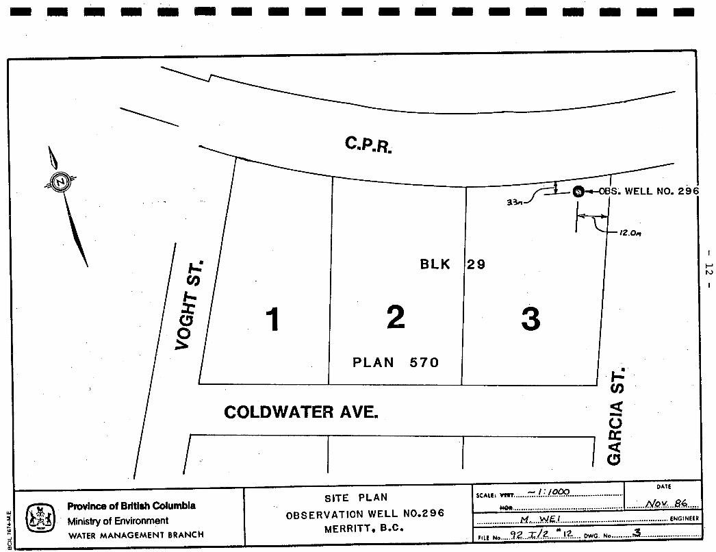
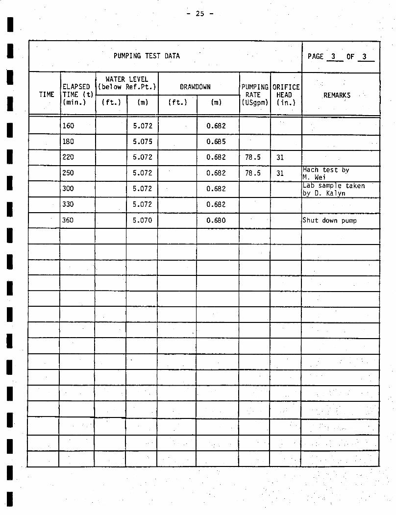
On March 4 , 1987, a constant ra te pumping t e s t was conducted us ing a
Berkeley 5 horse power submersible pump. The pump was s e t a t 11.7 metres
and the well was pumped for 6 hours a t a ra te o f 4.95 l i tres/second (78.5
USgpm). An o r i f i ce was se t up a t the end of the discharge l i ne
approximately 140 metres from the well i n order to measure the rate of
discharge. The i n i t i a l s t a t i c water level was 4.390 metres below the t o p of
the 152mm diameter casing and water levels stabil ized almost immediately
a f t e r pumping began (Appendix B ) . After 6 hours of pumping, the final water
level reading was 5.070 metres representing a drawdown of 0.680 metres or 8
percent of the total available drawdown to the t o p of the well screen.
Recovery was rap id w i t h the water level recovering t o w i t h i n 0.011 metres o f
the original s t a t i c water level only 4 minutes a f t e r pumping had stopped.
From the pumping t e s t resu l t s , a f t e r 360 minutes of pumping a specific

1 I I I i I I 1 I I 1 I 1 I I I 1 I
- 4 -
c a p a c i t y o f 7.28 1 i t res/second/metre (35.2 USgpm/ft) o f drawdown can be
ca l cu la ted . A t r a n s m i s s i v i t y value was ca l cu la ted (Appendix B) us ing
recovery data, and i s shown t o be i n the range o f 1.65 x 10'2m2/sec.
T r a n s m i s s i v i t i e s o f t h i s magnitude i n d i c a t e t h a t w e l l s i n t h i s type o f
a q u i f e r genera l l y make good i r r i g a t i o n we l ls . Using the above data and
u t i l i z i n g 70 pe rcen t o f the a v a i l a b l e drawdown, a t h e o r e t i c a l sa fe w e l l
y i e l d o f 45.5 l / s was ca lcu la ted . The w e l l capac i ty however i s l i m i t e d by
t h e screen design. The 50 -s lo t screen i n s t a l l e d has a t r a n s m i t t i n g capac i t y
o f approximately 6.3 1 / s (100 USgpm). I n o rde r to more accu ra te l y assess
t h e a q u i f e r s p o t e n t i a l i t would be necessary t o design a l a r g e r diameter
w e l l capable o f y i e l d i n g a much g rea te r volume of water.
WATER QUALITY
Two separate f i e l d water q u a l i t y t e s t s were conducted du r ing the pumping
t e s t us ing a Hach chemical ana lys i s k i t and c o n d u c t i v i t y meter. Resu l ts o f
these f i e l d analyses are as fo l l ows :

- 5 -
~~
OBSERVATION WELL NO 296 - MERRITT
MINUTES OF PUMPING F' PARAMETERS
Temperature
Spec i f i c Conductance
I H
41 k a l i n i ty
Hardness
Ch lor ide
I r o n
I 8.5 "C
158 umhos/cm
7.5
a5 mg/l
103 mg/l
~ 1 2 . 5 mg/l
250
~
8.5 "C
150 umhos/cm
7.0
85 mg/l
85 mg/l
4 2 . 5 mg/l
0.3 mg/l
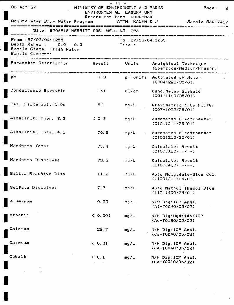
Water samples were a lso c o l l e c t e d a t 100 and 300 minutes i n t o the pump t e s t
and submit ted t o the Environmental Laboratory f o r a d e t a i l e d chemical
ana lys i s . Resul ts o f the two analyses were near ly i d e n t i c a l and are
a t tached i n Appendix C. Laboratory r e s u l t s i n d i c a t e the groundwater i s a
moderately minera l i z e d ca lc ium and magnesium-bicarbonate type which i s a1 so
f a i r l y s o f t . A l l water chemist ry parameters tes ted are w i t h i n the maximum
acceptable concent ra t ions set out i n "Guide1 ines f o r Canadian D r i n k i n g Water
Qual i t y 1978".
I n o rder t o determine the i n c r u s t i v e o r cor ros ive na ture o f the water,
c a l c u l a t i o n s using the Ryznar S t a b i l i t y Index were performed. Water with a

- 6 -
Ryznar S tab i l i ty Index value of greater than 7 i s said to be corrosive while
a value of l ess t h a n 7 i s considered to be incrustive. Using f i e l d and
laboratory resu l t s , an RSI value of 9.44 was calculated indicating the
groundwater has a potential to corrode. I t should be mentioned tha t this
well has been sampled i n l a t e 1987 for PCP contamination due to suspected
contamination from local mil 1 s using wood-preservatives. One sample taken
December 14, 1987 showed 25)~g/L PCP (Pentachlorophenol ) , (Wei, M. 1988).
HYDROGEOLOGY
A t present Groundwater Section has 2 1 well records i n Merritt. Some of the
wells were unsuccessful testholes and have been abandoned. Most of the
wells are l e s s than 100 f e e t deep and are completed i n t o a shallow gravel
and sand deposit which forms the principal aquifer i n the region. The
aquifer i s unconfined and is generally between 20 f e e t and 50 f e e t thick and
supplies several hundreds of gallons per minute to wells. The City of - -- -- .-
Merrit t and Co l l e t tv i l l e Improvement D i s t r i c t production wells are completed
i n the same deposit b u t i n a deeper gravel-fi l led channel. These production
wells have a capacity of about 1000 gpm to 1500gpm. T h i s channel, located
a t the northwest end of town i s apparently very narrow, up to a depth of 100
f e e t or more and may extend i n an east-northeast direction. Observation
Well No. 296 i s completed i n the aquifer b u t d id not encounter this channel
of coarse grained sediments by the Nicola and Coldwater Rivers.

- 7 -
I I 1 I I I E E I E I I I I I I
1 i
i
The aquifer transmissivity, ranges between 5x10⁴ and 10x104 gpd/ft , typical
of moderately transmi ssive aquifers. Regional fl ow appears to be downs1 ope
towards the west. Recharge to the aquifer may come from r ive r flow and
d i r e c t precipitation. The f ac t tha t the aquifer is permeable, unconfined
and located a t a shallow depth makes i t susceptible to pollution, regular
sampling of Observation Well No. 296 t o monitor water quali ty is recommended
and shou ld a lso include the tes t ing fo r PC contamination. q? The aquifer i s underlain by f i n d sand, s i l t and clay. T h i s depos i t outcrops
on the h i l l s ide beside the aquifer and forms an aquitard of about 200 feet
t o 250 f e e t thickness below the valley floor. The s i l t and clay deposit was
formed by depos i t ion of fine-gained sediments i n a prehistoric glacial lake
covering Merritt. The River Ranch wells just northeast of the c i t y are
completed i n t o sand and gravel layers i n or beneath this deposit. These
sand and gravel layers form flowing ar tes ian aquifers which reportedly
supply up t o 7000 gpm to wells b u t which are not well defined i n location.
Alluvial and glaciofluvial deposits associated w i t h the glaciolacustrine
deposit occur southeast and northwest of Merritt respectively (Figures 5 and
6 ) . Groundwater potential i n these depos i t s is unknown.
01 der unconsolidated deposits may l i e beneath the glaciolacustrine depos i t
and above bedrock. Presence of these unconsolidated deposits are inferred
from d r i l l log data only. Groundwater development i n these deeper deposits
have not been explored as most of the exploration, development and
exploitation of the groundwater resource has taken place i n the shallow,

- 8 -
productive sand and gravel aquifer i n which Observation well No. 296 i s
compl eted.
CONCLUSIONS AND RECOMMENDATIONS
1 1 1 1 I I 1 I I I I I I I I ,I
One 152mm diameter observation well was dr i l led for the Ministry of
Environment w i t h a t o t a l contract cost of $4462.82. The surf ic ia l
well was completed w i t h i n a unconfined aquifer t o a depth of 14.3
metres.
A1 1 water chemistry parameters tested are w i t h i n the maximum
acceptable concentration set o u t i n "Guide1 ines for Canadian Dr inking
Water Qual i t y 1978".
The observation well shou ld be sampled for complete water chemistry
analysis a t l ea s t once per year, and shou ld include tes t ing fo r PCP
contamination. The sampling shou ld be carried out i n l a t e summer - early Fa l l when groundwater levels are a t o r near their lowest.
The water level recorder ins ta l la t ion shou ld remain i n place for a
m i n i m u m period of 10 years. Water level and water qua l i t y data should
be reviewed periodically to monitor the groundwater conditions of the
aquifer.

REFERENCES
Driscoll , F1 t h
- 9 -
r G. 1986. Groundwat
Johnson Divis ion , St. Paul , Minnesota.
and Wells - S
1089 p.
!I Edi t ion .
Health and GIelfare Canada. 1979. Guidel ines for Canadian Drinking
Water Qual i t y 1978. Canadian Government Pub1 i shi ng Centre, H u l l , Quebec, Canada. 79 p .
Wei , M. 1986. Groundwater Observation Well Network Expansion Program
Proposal 1986/87 F i sca l Year, Minis t ry o f Environment, Victoria, B.C.,
Unpubl i shed memo. F i l e: 0183613-8
I I I I I I I I I I I I I I I I I I I
Wei, M. 1988. Chlorophenols i n Groundwater - Merritt.
Minis t ry of E & P , GWS, V i c t o r i a , B.C., Unpublished Memo.
File:92I/2.
I I I I I I I I I I I I I I
~I I ‘I I
II
Province of British Columbia Ministry of Environment WATER M A N A b t M k N T BRANCH
1 :50,000 DATE
MOR. ................................................................................. SCALE : VERT. ................................................. 1 APRIL 1988 ’
TO ACCOMPANY REPORT ON
MERRITT - OBSERVATION WELL No, 296
M. WE1 ........................................................................................ ENGINEER ~
FIGURE 1 fIlE No.. ................................. 92 I/2 #12 DWG. ho ...........................................

I I I
~1 I
I I I I I I I I
I I
'I I I
i
i
>
I S
D.L. ! !
I72 D Province of British Columbia Ministry of Environment WATER M A N A G E M E N T BRANCH
DATE b SCALE: Urn 1 __... r .... 8.m.: ... _..____.______..._
-. _.___._...__ ____..._________.____ _ _ _ _ _ _ _ _ _ _._.___ ... A~.K ..... ~Z........
. _ . * ., . : .&,.,'., 1 . . . . . .. . . .
LOCATION O F O B S . WELL NO. 296 . . . .
c
MERRITT. B.C.
._ ..______...._ M.I __.. W.E.! .___.____.____._ ~ _.__..__.__.__.______..__.._._..____ ENGINEER
. . , t FILE No ....?. 2..3[.1.2 .... .%. DWG. No. ..._.. 2. _.._.-......._._._._____ ______. 1
\
SCALEi Wlt ................................................. - I : /om SITE PLAN
w P r o v i k of Bhtlsh Columbia .........................................................
BLK
DAIE
NQV*.-.Sd..
2
' Ministry of Environment OBSERVATlON WELL N0.29 6 MERRITT, B.C.
WATER MANAGEMENT BRANCH
PLAN 5 7 0
......................... w ~ l ................................................ ENGINE
rllt N, ............ /2 ...~. !.2. ... DWG. No ......... d .......................
12.0- 17
COLDWATER AVE.

I I I I I I I I I I I I I I. I I I I
- 13 -
OBS. W€LL NU. 29b - MERRITT. B.C.
* 0 .
. * ' 0 . * *
a. e . * *
- 0 . '
* . * 0 . .
e e . e
* * e '
.
t
UOR. EXAG. 12 X
Province of British Columbia Ministry of Environment WATER MANAGEMENT BRANCH
7 0 ACCOMPANY REPORT ON -

- 14 -
I . I - - - ’ -
I I I I I I I I .I I I I I I i i I
SLJRFlCtAt G€OLOGY ME RRITT
Pmvinc6 of British Columbia Mnstry of Environment WATER MANAGEMENT BRANCH
SCALE: VERT ..... ............................... WOI ...
?O ACCOMPANY REPORT ON
...................... ~ € c ................................................. ENGINEER
r i i c Na...9Z.Xfz ......... m G , ,.FX.ME ..... 5 ......

I I I I I I I I I I I I I I I I I 'I I
- 1'5 - SCHEMATIC X-SECTION / MERRITT
5 \
2 -1900'
LEGEND
. [q 7 r u
NERRITT X
x
% X
x 8 X
VERT EXAG. 2JX . . . . . . . . . . . . .
. . . . . . . . . . . . . . . . . . . . . . . . . . < .. . .
. . . . . . . . . . . . .
. ' TO ACCOMCANY Rovince of Brctidr C d u m . . . . . . . :.' . . .
. . . . . . . Minstry of Environment .WATER M A N A G E M E N T BRANCH , \ . .
. . . . . . . . . .
-5 . . .
. . ~. . .
. . . . . . . . . . . . . . .
. . . .
. . : . . . . . .
. . . . I
. .
. . . _.. DATE ...................... kl€. .......................................,....~ .... ENGINEER
SCALE: VERT
7 2 1 2 n/
............. ..... WW. ...t.= ..a.cxx? ........ ....... I .... !!.BL!!.L86.-\.'' FILE NO ................. 1 DWG. N , , . . . ~ ~ G . ~ ~ :6.1

- 16 -
Appendix A
Well Log, Contract Cost, Sieve Analysis

&&ST I M A T E O 0 SURVEYED
ELEVAT I 0 N I D E P T H 4 7 1 OF-
I
II I C A S I N G OIAM. L E N G T H 45
CASING OIAM LENGTH e
TYPE 2 5 . METHOD OF C o N s ~ ~ u c T i o N AIR -, ROL SCREEN LOCATION 4 . 7 ' - 4 6 . 8 SCREEN 0 S I Z E -LENGTH 4 S A N I T A R Y SEAL Y E S 0 N O 0 S C R E E N 0 S I Z E L E N G T H T Y P E PERFORATED CASING 0 LENGTH PERFORATIONS FROM TO
GRAVEL PACK 0 L E N G T H , DlAM SIZE GRAVEL.ETC.
DISTANCE TO WATER 13.3 0 ESTIMATE0 WATER LEVEL FROM- OMEASUREO ELEVATION ARTESIAN PRESSURE ___
DATE OF WATER L E V E L M E A S ~ R E M ~ N T A U X S ~ Z WATER USE A S E W ~ E . L L
CHEMISTRY
D A T E
TOTAL DISSOLVED. SOLIDS -md TEMPERATURE-~C pn S I L I C A ( S I 0 2 1 m e / I
CONDUCTANCE AT 25.C TOTAL IRON (Fa1 mg/l TOTAL HARDNESS (COC0,I mg/l Amhos/cm
TOTAL A L K A L I N I T Y (COCO,) mg/I PHEN. A L K A L I N I T Y (Ca COS) mg/I MANGANESE(Mn1 mg/l
COLOUR- ODOUR TURBIDITY
ANIONS mol1 p m CATIONS mg/l * p m
CALCIUM (CO)
MAGNESIUM (Ma)
SODIUM ( N a ) P O T A S S I U M (K) 33 I RON (DISSOLVE 0) 33 C A R B O N A T E (COS)
BICARBONATE (KO,)
SULPHATE (SO,) CHLORIDE ( C I )
NO8 t NO, (NITROGEN)
TKN. (NITROGEN)
P n o s P t i o R u s (PI
I
T K N T O T A L KJELDAHL NITROGEE( CHEMISTRY S I T E NO m&q/a NOc N I T R I T E NOS 9 NITRATE
CHEMISTRY F I E L D T E S T S TEST ey a. KA LY A) DATEP/AR.~~L~L EQUIPMENT u s E o MACH f i r
C o r r l a W ~ lS&/ - v ,
S U P 84' C m l f 8 - C~mnroc csoC,qq &.+MSS 8S ikht - O&U
CONTENTS OF FOLDER
0 D R I L L LOG O P U M P TEST DATA 0 ChEMICAL ANALYSIS
OSIEVE ANALYSIS 0 GEOPHYSICAL LOGS 0 REPORT
OTHER
SOURCES OF INFORMATION
I KilnLooPs S H c + v 6s PROOUCTION TEST SUMMARY
)ATE A & k L ! . h l rEST BY -&j.-kLL l B L L k S L \ T I P & 5 BAIL TESTO PUMP TEST^ DURATION OF T E S T - - ~ ~ ~ S
PVAILABLE DRAWDOWN SPECIFIC C A P A C I T Y ~ ~ X S
RATE -8.g L6 DRAWDOWN NATER L E V E L AT CO
'ERMEABILITY STORAGE COEFE r R A N S M I SS I V 1 T Y A ! v d ./KT
RECOMMENDED PUMPING RATE RECOMMENDED PUMP SETTING

I I I I I I I I 1 I 1 1 I I I I I I 1
- i a -
M. Schibli Water Wells R.R. *2. LUMBY, B.C. VOE 2GO * (604) 547.- 694 5
March 12, 1987
- PROGRESS INVOICE
Ministry of Environment S Parks, Water Management Branch, Parliament Buildings, Victoria, B.C. V8V 1x5
Re: Observation Well in Merritt, B.C. Ccntract No. 84
1.
4. 5. 6. 7. 8.
13.
1 4 . 15. 16.
Item Qvant ity - Mobilization, set up & demobilization 6" drilled, cased & sampled 6" drive shoe Screen assembly Assemble & install screen Hourly rate to do authorized
56 Feet
4 Hptr~s .R 5 Hours work
Mobilization &.demobilization of pumping equipment Install E, remove test pump Constant rat e pump ing.'t es t Standby for pumping equipment and crew 1 Hour Generator rental
6 Hours
TOTAL
Amount Bid Price -- Lump Sum $ 350.00 $ 22lft $ 1,232.00 Lump Sum 4 85.00 Lump Sum -f $ 387.72 $ lzo !W4 'J &p- $ 480.00
jird- $ 85/hr
Lump Sum Lump Sum $ 60/hr
$ 40/hr Lump Sum *
* See Attached Invoices
Yours truly
Max Schibli
$ 425.00
$ 500.00 $ 250.00 $ 360.00
4G. 00 $ 353.10
4 4,462.82

E I E
I I
I I 1 E E I I
- 19 -
SIEVE ANA L Y S 1 S
I.WT. SAMPLE I/2" rite and over
LWT. ENTIRE SAMPLE t 1.0 3. + 4.1 11331.8 I size and over I 1 5 . 2 % I %
i . PERCENT SAMPLE 1/2'
DEPTH INTERVAL SCREEN OPENING ( F E E T )
I 28 1168 I ,
SIEVE
m: The following sieve analysis doe8 the 112' sire and over.
include
INTERVAL - - SI E V E CWIM. WT. RET C9M. % CUYY. WT. R E I CUYY. X
NO. IN grams RET. IN qrams RET.
4 530.0 4b. 1 Q 744.2 65.9
?n 50
1020.0 1070.4 94.8
REM ARK S :
-~ ~
NUMBER M 20 16 IO a 6 4
I : I ! . I I I1 I I I I I 1 I I I I 1 I I ' I I f I I I 1 I I . 1 I 1 1 I
I GRAIN SIZE - SIEVE OPENING, IN THOUSANDTHS OF AN INCH

I I I I I I I I I I I I I I I I I I I
- 20 -
SIEVE ANA L Y S 1 S ~
Cont rac t No. 84 'RO J E CT : Merri t t .OCATlON: 296 HELL NO.:
D. Kalyn iNALYSIS BY:
jAMPLE WEIGHT 8 INTERVAL IN grams -
. WT. CONTAINER + SAMPLE
!. WT. CONTAINER
L W T . SAMPLE less than 1/2* sire 1400.5
1. WT. S A M P L E 112" size 284.0 and over
1684.5 I 5.WT. ENTIRE SAMPLE
[ I . . 3. + 4.1
t i. PERCENT SAMPLE 1/2- rite ond over Yo
DEPTH INTERVAL SCREEN OPENING (FEET) 90% 5ovo 40% 30%
39 152 - 1 I I
SI E V E
w: The following sieve analysis doer & includr the m u rite and over.
NUMBER
I . , : I I ; r . I I I r I I I I I
10 20 30 *o 50 60 70 80 90 too IlO I20 1 3 0 I40 UO S O 170 Ibo
I I 1 : ; I I I 1 I I I I I I I I 4 i t ! . I I 1 I I * ! I I I 1 I I I I I
I . I
I . I I I ! , I . i I I 11 I 1 I I I 1 1 I I I I 1
GRAIN SIZE - SIEVE OPENING, IN THOUSANDTHS OF AN INCH

I I I I E I I I I I I I I I 1 I I
3.WT. SAMPLE less than 16 472.1 61.0
;. WT. SAMPLE I/Z" size 50 604.6 78.1 and over 780.4 100 621.4 8n.?
200 721.8 93.2
112" size 774.0 30 555.9 71.8
5.WT. ENTlRE SAMPLE I
DEPTH INTERVAL
I I
- 21 -
SIEVE A N A L Y S I S -
'RO J E CT: Contract No. 84 I u: The fdlowing sieve analysis do88 includr
! me Vt" size and over. Merri tt -0CATlON:
I 296 NELL NO.: I INTERVAL
?. WT. CONTAINER 8 I 368.7 I 47.6 II
1 I I f
REM ARK S ; - 4 85 140 ---- SIEVE NUMBER
GRAIN SIZE - SIEVE OPENING, IN THOUSANOTHS o f AN INCH

- 22 -
Appendix B
Pump Test Data
m I

1 ,
' I I I B B I I I B I E E I I I I I I I
0 - 23 -
PUMPING TEST DATA PAGE 1 OF 3 - -
PROJECT: Observation We1 1 Network Program WELL NO: 296
LOCATION: Merri tt TEST: Constant Rate
START OF TEST: 11:17 March 4 , 1987 END: 17:17 March 4, 1987
REFERENCE POINT: ( f t ) 0.340 (m) above 10" 0 Surface Casing
PUMP I NG SETTING : m) below Ref. P t . (Top of 6" OI Casing)
STATIC WATER LEVEL: ( f t ) 4.390 m) bel ow Ref. P t . (Top of 6" 0 Casing)
( f t ) 12.0
By: D. Kalyn and M. Wei
I
- 24 -
60 5.070 0.680
70 5.072 0.682
12:37 80 5.072 0.682 78.5 31
90 5.073 0.683
100 5.073 0.683
120 5.071 0.681
140 5.072 0.682 -
I I
I
1 I
i I
Lab sample take by D. Kalyn
Hach t e s t by 1 vn
I I I
I I I I I I I I I I I I I I I I I 1 I
- 2 5 -
PUMPING TEST DATA PAGE - 3 OF - 3
~~
RE MARKS
lath t e s t by I. Wei a b sample taken lv D. Kalvn
’
hu t down pump

' I I
1 1 I I I 1 I 6 I I I I I 1 1 I 1 I
- 26 -
~ ~~~~
RECOVERY DATA PAGE 1 OF 2 --
PROJECT: Observation Well Network Program WELL NO: 296
LOCATION: Merri tt TEST: Constant Rate
REFERENCE POINT: ( f t ) 0.340 (m) above 10" 0 Surface Casing
STATIC WATER LEVEL: ( f t ) 4.390 ( m ) below Ref. P t . (Top of 6" 0 Casing)
by: D. Kalyn and M. Wei
RESIDUAL DRAWDOWN WATER LEVEL
I I I I I I I I

i 11 ~
' I 11 1 I I 1 I I I I I I I 1 I I I I
415 55 7.5 4.398 0.008
420 60 I 4.398 0.008
08:OO 1243 883 1.4 4.392 0.002
7
-
. . .. . ..
- 27 -
RECOVERY DATA
RESIDUAL DRAWDOWN WATER LEVEL
'AGE 2 OF 2 --
. . . .
REMARKS
V i r t u a l l y fully recovered

w k ~ SEMI-LOGARITHMIC 46 6012 - --. \ 4 CYCLES X 70 DIVISIONS Y i Y L I N U 5 A. 1
KEUFFEL L ESSER CO.
i
h, cn I

I I I I I I I I I I I I I I I I I I I
- 29 -
Appendix C
Water Qua l i ty Lab Analyses

Phone No.
I Audit Sample 387-1 11 5
0 Client study reference code ( ) Sampling agency code (14)
Site (E2C6918) MERRITT ODs. WELL NO. 296 I I Sample Adjective (
I This f o r m was processed to the computer on 5-i-1AH-1987 as REGULAR
Satnp le State (FWj Fresh Waker Sample Descriptor (GE) General
The C o s t for analgring samples f o r t h i s f o r m is
Routine analysis: $ 238.130
I T o t a l 8 239. 80
Sp o c ial analysis: .$; 0. 00 ----.-------- --
I
Conductance Specific ~I
Alkalinity Phen. 8. 3
I1 , Alkalinitq Total 4.5
I Hardness Dissolved I Silica Reactive Diss I Sulfate Dissolved
Aluminum I1 A r s e n i c I I I
Cobalt
7. 0
161
94
.< 0. 5
70. 9
75. 4
73. 5
11.2
7. 7
0. 03
< 0.001
22. 7
< 0.01
c 0. 1
pH units Automated pH Meter
uS/cm
"9 / L
m g /L
mg /L
mg /L
m g / L
mg / I ,
mg /I,
rng /L
mg /L
mg /L
m g / L
mg /L
Cond. Meter Siebold (C0111160/35/01)
GTavimetric 1. Ou FiltBr (007H1032/35/01)
Automated Electrometer (010112?1/35/01)
Automated Electrometer (01021210/35/01~
Calculated Result 1C107CALC/--/--)
Calculated Result (1107CALC/--/--)
Auto Molybdate-Blue Col. (11201381/35/01)
Auto Methyl Thqmol Blue (11211400/35/01)
N/H Dig: ICP Ana?. (Al-TC040/05/02)
N/H Dig: Hydride/ICP (As-T0180/05/02~
N / H Dig:ICP Anal. (Ca-T0040/05/02)
N/H Dig:ICP Anal. (Cd-T0040/05/02)
N/H Dig:ICP Anal. (Co-T0040/05/02)

I r o n I E a g n e s ium
Manganese I
M o i y b d enum
Nickel I I Lead E Vanadium I Zinc
Aluminum Dissolved I
< 0.01 mg /L N/H Dig:ICP Anal. (C~-T0040/05/02)
0. 02 mg /L N/'H Dig: IC2 A n a l . (Fe-T0040/05/02)
4. 54 mg /L N / H Dig: IC? Anal.' (Mg-T0040/05 iGZ! i
.:: 0.01 m3 /L N/H Dig:ICP Anal. (Mn-T0040/05/02)
-C 0. 01 m g / I , N/H g i g : IC? Anal. ( M c - T G @ 4 0 / 0 5 i 0 2 )
.< 0. 05 mg /L N/H Dig: ICP Anal. ( N i - T 0 0 4 0 / 0 5 / 0 2 )
< 0. 1 mg /L N/H Dig: IC? Anal. ( P b - T 0 0 4 0 / 0 5 / 0 2 )
< O . Q 1 mg /L N/H Dig: ICP Anal. ( V - - T O G 4 0 / 0 5 / 0 2 )
.< 0. 01 mg /L N/H Dig: IC? Anal. (Zn-T0040/05/02)
< 0.02 m g / L ICP Analysis (Ai-DC030/05/13)
6t.r s en ic D i s so 1 ved < 0.001 mg /L Hg dr i d e/ IC? Ana 1. (As-D0170/05/13)
Goron Dissolved
I < 0.01 mg /L ICP Analysis (B--D0030/05/13)
0. 03 m g / L ICP Analysis (Ba-D0030/05/13)

Cadmium Dissolved I Cobalt Dissolved I Chromium Dissolved
I Copper Dissolved
Iron Dissolved I I Potassium Dissolved I Magnesium Dissolved I Manganes'e Dissolved
< 0.01 mg /L ICP Analysis (Cd-D0030/05/13)
< 0. 1 mg /L ICP Analysis (Co-D0030/05/13)
< 0.01 mg /L ICP Analysis (Cr-D0030/05/13)
.c 0.01 mg /L ICP Analysis (C~-D0030/05/13)
0. 02 mg /L ICP Analysis (Fe-D0030/05/13)
0. 6 mg /L Auto. Flame Emmission (H--D1331/35/01)
4. 40 mg /L ICP Analysis (Mg-D0030/05/13)
< 0.01 mg/L ICP Analysis (Mn-D0030/05/13)
I ,Molybdenum Dissolved < 0". 01 mg/L ICP Analysis (Mo-D0030/05/13)
Nickel Dissolved I *C 0. 05 mg /L ICP Ana 1 q s i 5
(Ni-D0030/05/13)
I Lead Dissolved c 0. 1 mg /L
Vanadium Dissolved
I Zinc Dissolved
ICP Analysis (Pb-D0030/05/13)
c 0.01 mg /L ICP Analysis (V--D0030/05/13)
< 0.01 mg /L ICP Analysis (Zn-D0030/05/13)
I 1

I ' I I I I I I I I I I I
From : 87/03/04: 1255 T o : 87/03/04: 1255 Depth Range : o.'o 0. 0 Tide : Sample State: Fresh Water Sample Comment:
Parameter Description Result Units Analytical Technique ------------------------------.--------------------------------------------------
(Sparcode/Medium/Pres 'n 1 ................................................................................ Nitrogen Organic-Tot < 0.02 mg /L Calculated Result
(0112CALC/--/--)
Nitrogen Kjel. T o t ( N )
Nitrogen T o t a l
Nitrogen Amm. Diss(N)
Nitrogen NOZ+N02 I ) i s
Nitrogen NO3 Diss(N)
0. 02 mg /L Block Dig. Auto. Color (#1131360/35/01)
0. 20 mg/L Calculatsd Result (0114CALC/--/--)
< 0.005 mg /L Automated Bertholot rnsth (11081351/35/01)
0. 18 mg /L A u t o . Cadmium Reduction (11091350/35/01)
0. 10 m g / L Calculated Result (iIlOCALC/--/--)
Nitrogen NO2 Diss(N) < 0.005 mg/L Auto. Diazotization (11111354/35/01)
Phosphorus ar t . Dis-P
I Phosphorus Total (Sodium Dissolved
(Chloride Dissolved
I I I I
< 0.003 mg/L Auto. Ascorbic Acid (11181380/35/01)
< 0. 003 mg/L Dig. Auto. Ascorbic Acid . (P--T1390/35/01)
3. 7 mg /L Auto. Flame Emmission (Na-D1331/35/01)
1. & mg /L Auto. mercuric thiocyan. (11041330/35/01)
I
- 35 - MINISTHY O F ENVIRONMENT AND PARKS Page- 1
APR 10 1987 ENVIRONMENTAL LABG3ATORY R e p o r t f o r f o r m 00008865
ATTN: KALYN D J I 08-.Apr-87 Groundwater Br.- Water Program . . . . . . . . . . . . . . . . . . . . . . . . . . . . . . . . . . . . . . . . . . . . . . . . . . . . . . . . . . . . . . . . . . . . . . . . . . . . . . .
Site: E206918 MERRITT OBS. WELL NO. 296 ----------------_-_,-----~--------------------------------------------------------
Submitted b y (44954) KALYN D J I (Address (16) Water Management Branch
I Victoria, BC V8V 1x5
Groundwater Section 4 t h Floor, 765 Broughton Street
387-1 115
0
Phone No.
Aud it Samp 1 e Client study reference code ( 1 Sampling agency code (14)
Sits (E205919) MERRITT OBS. WELL NO. 296
I I (%mple Adjective ( 1
'This f o r m was processed to the computer on 5-MAR-19E7 as REGULAR
Sample State (FW) Fresh Water Sample Descriptor (GE) General
T h e cost for analyzing samples f a r t h i s f o r m is
R o u t i n e analysis: 9 239. 80
I T o t a l 3 238. 80
S p e c i a l analqsi;: . B 0. 00 -------------- I
I I I I I I I I

- 36 - ENVIRONPIENTAL LABORATCRY Report for form OQOOS365
Groundwater B r . - Water Program ATTN: KALYN D J Sample 86017468
MINISTRY OF ENVIRONMENT AND PARXS Page- 2
-------------------------------------------------------------------------------- ................................................................................ Site: E206918 MERRITT OBS. WELL NO. 296 ................................................................................
From : 87/03/04: 1600 To : 87/03/04: 1600 Depth Range : o.,a 0. 0 Tide :
Sample Comment:
Parameter Description Result Units Analytical Technique
'Sample State: Fresh Water
................................................................................ (Sparcode/Medium/Pr~s 'n 1 ................................................................................
7. 0 p H units Automated pH Meter
1 Conductance Specific 161 uS/cm Cond. Meter Siebold
(00041220/35/01)
(00111160/35/01)
Res. Filterable 1. Ou I Alkalinity Phen. 8.3 I Alkalinity Total 4. 5
I Hardness T o t a l
Hardness Dissolved I I S i l i c a Reactive Diss
(Sulfate Dissolved
< 0.5 mg /L Automated Electrometer (01#11211/35/01)
I Aluminum Arsenic I Icalcium
92 mg /L Gravimetric 1 . 0 ~ Filter . (C07H1032/35/01)
71. 8 mg /L Automated Electrometer (01051210/35/01)
70. 2 mg /L Calculated Result (0?07CALC/- - / - - )
73.3 my /L Calculated Result (liOiCALC/--/--)
11.3 m g / L Auto molybdate-Blue Col. (11201331/35/#1)
7. 4 mg /L Au.to Methyl Thymol Blue
< 0.02 mg /L N/H Dig:ICP Anal. (41-T0040/05/02 1
c 0.001 m g / L N / i i Dig: Hydride/ICP ( A s - T 0 1 8 0 / O S / 0 2 )
23. 7 mg /L N/H Dig:ICF Anal. (Ca-T0040/05/02)
< 0.01 mg /L N/H Dig:ICP Anal. ( C d - T 0 0 4 0 / 0 5 / C 2 )
c a. 1 mg /L W H Dig:ICP Anal. (C*-T0040/05/02)
I '

I ' I I I I I -I I
Chromium
C o p p e r
Iron
Magnosium
Maog an e 9 e
Moly b denurn
I V i c k e l I L.3 a d
Zinc I Aluminum Dissolved I Ar s en i c D i s s o 1 v e d I
,Boron Dissolved
Darium Dissolved
0. 0 1
-< 0. 01
.< 0. c31
4. 63
mg /L
mg /L
mg /L
mg /L
rng I'L
mg /L
m3 r'L
mg /L
rng / I -
rng /L
mg /L
m g / L
mg /L
mg /L
N/H Dig: ICP Ana?. (C~-T0040/05/G2)
NiH Dig: I C P Anal. (2~-T0040/05/02)
N/H D i g : ICP Anal. ' (Fe-T0040/(55/C2)
N/:i Dig: ICP Anal. (Mg-T0040 /G5 /02 )
N/H D i g : ICP Anal. (Mn-T0040/05/02>
td/s E f g : I C P A n a l . (Mo-TCG40/C5/02i
N/H Dig: ICP A v a l . ~Ni-TCC40/05/02)
N i ' H Dig: IC? Anal. ( f b - T C W G / G 5 / 0 2 ?
N!!i Elg: I C ? Anal. .( V--T004WQ5/C2 j
wx Dig: ICF Anal. ( Z ~ - T O W O / O ~ ; G ~ ~
I C ? Analysis ( Ai -D0030/05/ 13 1
Hy 4 7 i d e/ I C B Ana 1. (As-D0170/05/13)
ICP Analysis (B--D0030/05/13)
ICP Analysis (3a-D0030/05/13)
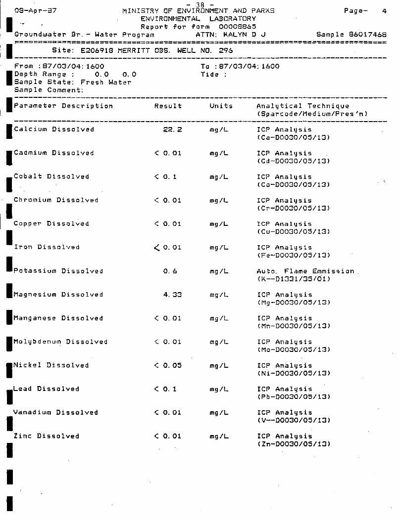
- 38 - 09-Apr-ai MINISTP,Y OF E N V I R O N M E N T AND PARKS Page- 4
ENVIRONMENTAL LABCRATORY Report for form OOOC8i355
ATTN: K A L Y N D J Sample 06017466 I .-
I I I
Groundwater Br.- Water Program -----------------------------.-------------------------------------------------- ------------------------------.--------------------------------------------------
Site: E206918 f l E R R I T T QBS. WELL NO. 296 ................................................................................ F r o m : 87/03/04: 1600 To : 87/03/04: 1600 Depth Range : 0.0 0.0 Tide : Sample State: F r e s h Water Sample Comment:
Parameter Description Result Units Analytical Technique --------------------------------------------------------------------------------
(Sparcode/Medium/Pres 'n) -------------------------------------------------------------------------------- (Calcium Dissolved
Cadmium Dissolved I Cobalt Dissolved I . .
Chromium Dissolved
Copprr Dissolved
Iron Dissolved I IPotassium Dissolved
I Magnesium Dissolved
22. 2
c 0.01
<: 0. 1
c 0.01
< 0.01
< 0.01
0. 6
4. 33
(Manganese Dissolved
(Molybdenum Dissolved
Nickel Dissolved I ,Lead Dissolved
Vanadium Dissolved
I -
Zinc Dissolved
< 0.01
.i: 0. 0 1
< 0.05
<: 0. 1
c 0.01
< 0.01
mg /L
mg /L
mg /L
mg /L
m g / L
mg /L
mg /L
mg /L
mg /L
mg /L
mg /L
mg /L
mg /L
mg /L
ICP Analysis (Ca-D0030/05/13)
IC? Analysis (Cd-~0030/05/13)
IC? Analysis (Co-D0030/05/13)
IC? Analysis (Cr-D0030/05/13)
I C P AnalcJsis (C~-DOO30/05/13)
IC? Analysis (Fe-D0030/05/13)
Auto. Flame Enmission (K--D1331/35/41)
ICP Analysis (Mg-D0030/05/13)
IC? Analysis (Mn-D0030/05/13)
ICP Analysis (Mo-DC030/05/13)
ICP Analysis (Ni-D0030/05/13)
ICP Analysis (Pb-D0030/05/13)
ICP Analysis (V--D0030/05/13)
ICP Analysis (Zn-D0030/05/13)

I
MINISTRY OF E$I???I&ENT AND PARKS Page- 5
1 Groundwater B r . - Water Program ATTN: KALYN D J Sample 86017468
: . 08-Apr-87 ENVIRONMENTAL LADORATORY Report for f o r m 00008865 ‘I .:.. -.
‘I 38==========================----================---------==============---------
Site: E206918 MERRITT OBS. WELL NO. 296 ................................................................................ F r o m : 87/03/04: 1600 To : 87/03/04: 1600
‘(Depth Range : 0:o 0. 0 Tide : I Sample State: Fresh Mater f sample Comment: ................................................................................ I Parameter Description Result Units Analytical Technique
(Sparcode/Medium/Pres‘n) ................................................................................ I Nitrogen Organic-Tot c 0.01 mg /L Calculated Result (C112CAlC/--/--)
I (01131360/35/01)
I Nitrogen Total 0. 16 mg /L .Calculated Result
Nitrogen Kjel. Tot(N) 0. 01 mg/L Block Dig. Auto. Color
(Gil4CALC/--/--)
Nitrogen Amrn. Diss(N1 c 0.005 mg /L Automated Bertholot meth (11031351/35/01)
Nitrogen N03+iU02 D i s 0. 15 mg /L Auto. Cadmium Reduction I I I
(110913S0/35/01)
Nitrogen NOS Diss(N) 0. 15 mg /L Calculated Result (1110CALC/--/--)
Nitrogen NO2 Diss(N) < 0.003 mg /L Auto. Diazotization (11111354/35/@1)
I Phosphorus O r t . Dis-P .< 0. 003 mg /L Auto. Ascorbic Acid
I Phosphorus Total < 0.003 mg/L Dig. Auto. Ascorbic Acid (P--T1370/35/01)
Sodium Dissolved 3. 7 mg /L Auto. Flame Enmission 1 (Na-D1331/35/01)
I (11041330/35/01)
(11181380/35/01)
Chloride Dissolved 1. 6 mg/L Auto. mercuric thiocyan.
I I I I I

I I I I I I I I I I I I I I I I I I I
- 40 -
Appendix D
Water Level Recorder I n s t a l l a t i o n Spec i f i ca t i ons

- 41 -
Ministry of Environment and p a r k q \ n E 0 RAN D U M Province of
British Columbia WATER MANAGEMENT
BRANCH ' I I I I 1 I I I I I 1 I I I I I I
TO: W . S . Hodge
Groundwater Section Water Man a gene n t Branch
- Senior Technician -Date: A p r i l 7, 1987
Our File: 0183613-B-296
Re: Establishment of Observation Well No. 296 - Merrit t , B.C.
Introduction
On March 5 , 1987, a Stevens water level recorder was installeG on the recently dr i l led observation well i n Merritt. T h i s well was dr i l led under government Contract No. 84 - "Drilling, Construction and Testing of One Groundwater Observation Well i n Merritt, B.C." The well i s located along Coldwater Avenue on Lot 3, Block 29, P l a n 570, KDYD ( see Figures 1 and 2 ) . T h i s property i s owned by the Crown and permission to d r i l l was granted by the British Columbia B u i l d i n g s Corporation.
The purpose of establishing this observation well i s t o monitor groundwater conditions i n the Merritt aquifer. The City of Merr i t t ' s residents rely exclusively upon groundwater for the i r domestic water supply. The potential e x i s t s f o r the City of Merr i t t ' s population to increase w i t h the new Coquihalla Highway now open and Merritt being on a major transportation route.
Well Construction
Date Drilled - March 2-3, 1987 Well Depth - 17.07 m (56 f ee t ) We1 1 Diameter - 152 mn (6 inch) Aquifer Description - Sand and gravel S t a t i c Water Level - 4.05 m (13.3 f ee t ) below ground level Dri 11 i ng Contractor - M. Schibli Water Wells
Recorder I n s t a l l a t i o n Specifications
1 A1 urninurn housing 1 1 1 127 mm di ameter f l oat 1 1 Viro lock
Wood recorder stand w i t h pul1e.y Stevens water level recorder w i t h quartz mu1 ti speed timer
10 m length of graduated f loa t tape
0 0 0 2

.- ... . . i . __. . . ... . .. ..
- 4 2 -
- 2 -
W.S. Hodge- Apr i l 7, 1987
Ground Level Datum Measurements (March 5, 1987)
Sta t i c Water Level t o Pointer - 5.475 m Ground Level t o Pointer - 1.430 m Tape Reading - 4.061 m
The correction factor t o be applied t o the tape reading i s therefore -0.016 metres.
Observer: 'Mr. Tom B a k a l u k Ministry of Forests and Lands Box 609 Merri tt, B.C. VbK 280 Telephone: 378-9315 (Warehouse)
or 378-9311
I I I I I I I I I I I I I I I I I I
D. Kalyn Technician Groundwater Section Water Management Branch 387-9458
DK/dma
cc: Mr. L. Hundal Water Management, Kamloops

- 43 -
Appendix E
Photographs
I I I I I I I I I I I I I I I I I I I

~ - 4 4 -
!?

I I I I I I I I I I I I I I I I I
- 45 -

I I I I
I
I
I I
I I I I I
- 4 6 -
r